Mountain ranges in India reflect diverse geological processes, from continental collision and folding in the Himalayas to ancient erosion, faulting, uplift and volcanic activity across the Peninsular region. India has a highly varied mountain system extending from the Karakoram and Himalayas in the north to the Western and Eastern Ghats in the south, with several old residual and structural ranges spread across central, western and northeastern India.
Mountain Ranges in India influence climate, monsoon rainfall, river systems, biodiversity, agriculture, mineral resources, settlements and national security. The Himalayas are geologically young and tectonically active, whereas many peninsular ranges are much older and have undergone prolonged erosion and denudation. The classification places the Himalayas and other peninsular mountains within India's major geological framework.
Mountain Ranges in India Overview
Mountain ranges in India are interconnected or associated groups of elevated landforms created by tectonic movements, folding, faulting, volcanic activity, uplift, erosion and other geological processes over different periods.
- They differ considerably in age, origin, elevation, geological structure, orientation and ecological characteristics.
- The Himalayan system represents relatively young tectonic mountains, while the Aravallis, Vindhyas, Satpuras and several Peninsular hills represent older and extensively denuded landscapes.
- The Himalayas are part of a young, tectonically active mountain system, whereas the Peninsular mountains are associated with the ancient and relatively stable Peninsular Block and have been extensively modified by erosion and denudation.
Mountain Ranges in India Formation
The formation of mountain ranges in India is linked to plate movements, continental collision, folding, faulting, volcanic activity, uplift and prolonged erosion that produced contrasting mountain landscapes.
- Himalayan formation: The Himalayas developed through the northward movement of the Indian Plate and its collision with the Eurasian Plate. Compression caused folding, thrusting and uplift of sediments and rocks, creating the young fold-mountain system.
- The Indian Plate continues to move northward, making the Himalayan region tectonically active and prone to earthquakes, landslides and other geomorphic processes.
- Formation of Peninsular mountains: The Peninsular region is based on an ancient and relatively stable geological block consisting largely of old crystalline rocks. However, vertical movements, block faulting, fractures, uplift and erosion have produced ranges, scarps, residual hills and rift valleys.
- The Aravallis, Nallamala, Javadi, Velikonda, Palkonda and Mahendragiri hills are examples of relict or residual mountains.
- Volcanic and erosional influence: Volcanic activity contributed to the geological foundation of parts of the Deccan region, while prolonged weathering and erosion modified older mountain systems. Consequently, several peninsular ranges today have relatively moderate elevations and dissected or residual forms.


Mountain Ranges in India Important Ranges
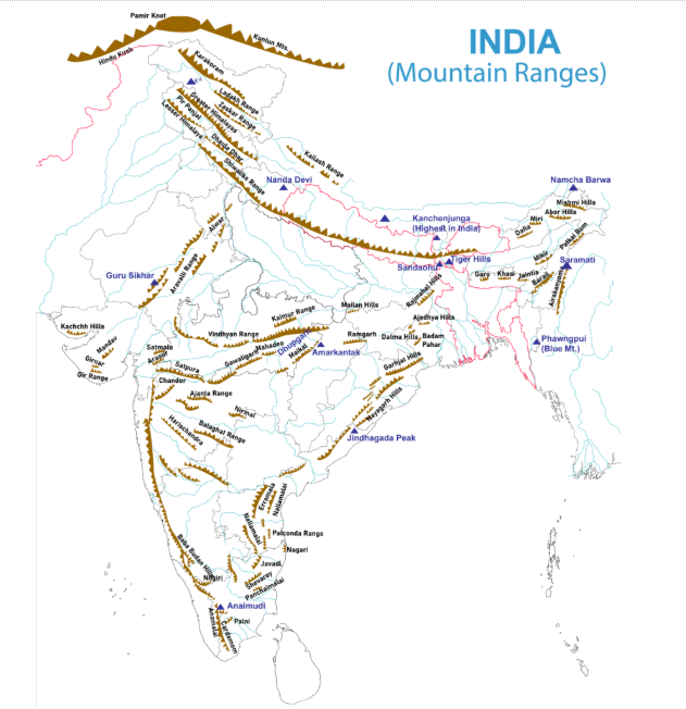
The major mountain ranges in India can be broadly studied region-wise as Northern and Trans-Himalayan ranges, Northeastern or Purvanchal ranges, Central and Western Indian ranges, and Southern Peninsular ranges.
- The following classification combines the regional coverage of the supplied mountain-range source with the physiographic framework and named ranges.
Mountain Ranges of Northern India
The northern mountain ranges comprise the Himalayas and Trans-Himalayan ranges, forming India's highest and most extensive mountain system and influencing climate, drainage, ecology and national security.
Northern Mountains – Himalayas and Trans-Himalayas
| Broad Region | Mountain Range / Hill System | Important Sub-Ranges / Hills | Major States / Regions | Important Peak / Feature |
|
Trans - Himalaya |
Karakoram Range |
Siachen region, Saltoro Range |
Ladakh |
K2/Godwin Austin; Siachen Glacier |
|
Trans - Himalaya |
Ladakh Range |
Ladakh mountains |
Ladakh |
Important high-altitude cold-desert range |
|
Trans - Himalaya |
Zanskar Range |
Zanskar Mountains |
Ladakh, Himachal Pradesh |
High-altitude valleys and passes |
|
Trans - Himalaya |
Kailash Range |
Mount Kailash region |
Tibet, beyond Indian territory |
Source region of major Asian rivers |
|
Himalaya |
Greater Himalaya / Himadri |
Main Himalayan Range |
Jammu & Kashmir/Ladakh, Himachal Pradesh, Uttarakhand, Sikkim, Arunachal Pradesh |
Kanchenjunga, Nanda Devi and other high peaks |
|
Himalaya |
Lesser Himalaya / Himachal |
Pir Panjal, Dhauladhar, Mussoorie Range, Nag Tibba Range |
Jammu & Kashmir, Himachal Pradesh, Uttarakhand |
Major valleys and hill stations |
|
Himalaya |
Shiwalik / Outer Himalaya |
Jammu Hills, Churia-type foothills |
Jammu & Kashmir, Himachal Pradesh, Punjab, Haryana, Uttarakhand and Sikkim |
Southernmost Himalayan range |
|
Himalaya |
Pir Panjal Range |
Pir Panjal Mountains |
Jammu & Kashmir, Himachal Pradesh |
Important range of the Lesser Himalaya |
|
Himalaya |
Dhauladhar Range |
Dhauladhar Mountains |
Himachal Pradesh |
Dharamshala–Kangra region |
|
Himalaya |
Mussoorie Range |
Mussoorie hills |
Uttarakhand |
Mussoorie hill region |
|
Himalaya |
Nag Tibba Range |
Nag Tibba hills |
Uttarakhand |
Important Lesser Himalayan hill system |
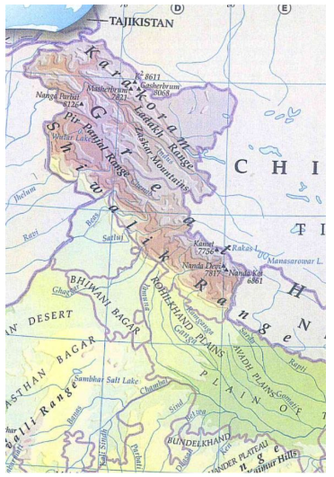
- Himalayan Range: The Himalayas form a series of approximately parallel ranges extending across the northern part of the Indian subcontinent. The Great Himalayan range is about 2,500 km long, while its width varies approximately between 160 and 400 km. Its three divisions are explained in the points below.
- Greater Himalayas or Himadri: The Greater Himalayas, also called the Himadri, constitute the highest and northernmost major Himalayan range.
- The average elevation is around 6,000 m (about 20,000 feet).
- It contains numerous permanently snow-covered peaks and glaciers.
- Important passes include Zoji La, Shipki La, Nathu La, Niti Pass and Burzil Pass.
- Important glaciers include Gangotri and Yamunotri.
- The range extends across parts of Ladakh, Jammu and Kashmir, Himachal Pradesh, Uttarakhand, Sikkim, West Bengal and Arunachal Pradesh.
- Lesser Himalayas or Himachal: The Lesser Himalayas, also called the Himachal, lie between the Greater Himalayas and the Shiwaliks. Important ranges of the Lesser Himalayas are
- Pir Panjal Range: A major range of the western Lesser Himalayas, extending mainly across Jammu and Kashmir and Himachal Pradesh.
- Dhauladhar Range: A prominent mountain range of Himachal Pradesh, rising sharply above the Kangra Valley.
- Kumaon Hills: Located in Uttarakhand, these hills contain important peaks and valleys and form a significant part of the central Lesser Himalayas.
- Nag Tibba Range: A lower Himalayan range in Uttarakhand, known for its forested hills and trekking landscapes.
- Mussoorie Range: A Himalayan hill range in Uttarakhand associated with the Mussoorie hill region.
- Mahabharat Range: A major range of the Lesser Himalayas extending across Nepal and forming an important middle Himalayan landscape.
- The region contains important valleys and hill stations, including Kashmir, Kangra, Kullu, Shimla, Mussoorie, Nainital and Darjeeling. The supplied source identifies Pir Panjal and Dhauladhar as major components of this Himalayan division.
- Shiwalik or Outer Himalayas: The Shiwalik Range forms the outermost and southernmost Himalayan belt.
- It generally has lower elevations than the Greater and Lesser Himalayas and consists substantially of unconsolidated sediments and conglomerates.
- The range is associated with valleys known as Duns, including the Dehradun valley.
- It passes through several Indian states of Jammu and Kashmir, Himachal Pradesh, Punjab, Haryana (pockets along the border), Uttarakhand (Southeastern extension), Uttar Pradesh (northern fringe areas), West Bengal (sub-Himalayan northern parts, like the Darjeeling foothills) and Sikkim.
Trans-Himalayan Mountain Ranges
The Trans-Himalayan ranges lie mainly north of the Great Himalayas and include some of the world's highest, coldest and most glaciated mountain landscapes.
- Karakoram Range: The Karakoram Range lies to the north of the Ladakh region and contains some of the highest peaks and largest glaciers of the greater Himalayan region. Important features include:
- K2
- Siachen Glacier
- Biafo Glacier
- Karakoram Pass
- The range forms an important high-altitude geographical and strategic region
- Ladakh Range: The Ladakh Range runs broadly through the Ladakh region and forms part of the Trans-Himalayan mountain system. It is characterised by:
- high-altitude terrain;
- cold desert conditions;
- sparse vegetation;
- deep valleys;
- high mountain passes; and
- landscapes drained principally by the Indus system.
- Khardung La and Digar La are important passes associated with the range.
- Zanskar Range: The Zanskar Range lies south of the Ladakh Range and is associated with the high-altitude landscape of Ladakh and adjoining regions.
- It contains important peaks such as Nun and Kun and remains heavily snow-covered in winter.
- Kailash Range: The Kailash Range lies mainly in the Tibetan region and is geographically associated with the Trans-Himalayan system. Mount Kailash is an important religious and cultural landmark for several Asian religious traditions.
Northeastern Mountain Ranges: Purvanchal
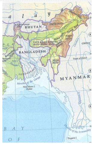
The Purvanchal ranges form the northeastern continuation of the Himalayan system, bending southward beyond the Dihang Gorge and forming important geographical features along India's northeastern frontier.
| Region | Mountain Range / Hills | Major State / Area | Important Feature |
|
Purvanchal |
Patkai Hills / Patkai Bum |
Arunachal Pradesh, Nagaland and adjoining Northeast |
Eastern extension of the Himalayan mountain system |
|
Purvanchal |
Naga Hills |
Nagaland |
Saramati is an important peak. |
|
Purvanchal |
Manipur Hills |
Manipur |
Hilly terrain surrounding the Manipur valley |
|
Purvanchal |
Mizo Hills / Lushai Hills |
Mizoram |
Phawngpui/Blue Mountain is a prominent peak |
|
Northeast |
Mishmi Hills |
Arunachal Pradesh |
Eastern Himalayan hill system |
|
Northeast |
Dafla Hills |
Arunachal Pradesh |
Part of the northeastern hill system |
|
Northeast |
Abor Hills |
Arunachal Pradesh |
Located around the Siang region |
|
Northeast |
Khasi Hills |
Meghalaya |
Part of the Meghalaya Plateau |
|
Northeast |
Jaintia Hills |
Meghalaya |
Eastern part of the Meghalaya Plateau |
|
Northeast |
Garo Hills |
Meghalaya |
Western part of the Meghalaya Plateau |
|
Northeast |
North Cachar Hills / Dima Hasao Hills |
Assam |
Northeastern extension of the Peninsular Plateau |
- Patkai Hills: The Patkai Hills extend along parts of the India–Myanmar frontier and form an important northeastern mountain system. They are associated with sandstone formations and dense forest landscapes.
- Naga Hills: The Naga Hills extend through Nagaland and adjoining areas. Mount Saramati is the highest peak of Nagaland.
- The Naga and Patkai systems together form an important watershed along the India–Myanmar region.
- Garo, Khasi and Jaintia Hills: The Meghalaya Plateau contains three prominent hill systems:
- Garo Hills
- Khasi Hills
- Jaintia Hills
- The Meghalaya Plateau is an extension of the Peninsular Plateau separated from the main block through geological processes.
Mountain Ranges of India in the Western and Central Regions
The western and central regions of India contain some of the country's oldest mountain systems, including the Aravallis, Vindhyas and Satpuras, which have been extensively modified by erosion and geological movements.
| Region | Mountain Range / Hills | Major States / Regions | Important Peak / Feature |
|
Northwestern India |
Aravalli Range |
Rajasthan, Haryana, Delhi, Gujarat |
Guru Shikhar – highest point of Aravallis |
|
Central India |
Vindhya Range |
Madhya Pradesh, Uttar Pradesh and adjoining areas |
Important escarpment and watershed system |
|
Central India |
Satpura Range |
Madhya Pradesh, Maharashtra |
Dhupgarh – highest point of Satpura |
|
Central India |
Mahadeo Hills |
Madhya Pradesh |
Important Satpura subdivision |
|
Central India |
Maikal Range |
Madhya Pradesh, Chhattisgarh |
Associated with the Amarkantak region |
|
Central India |
Kaimur Range |
Madhya Pradesh, Uttar Pradesh, Bihar |
Eastern extension of the Vindhyan system |
|
Central India |
Rajmahal Hills |
Jharkhand |
Eastern margin of the Peninsular Plateau |
|
Central India |
Gawilgarh Hills |
Maharashtra |
Part of the Satpura system |
|
Central India |
Ajanta Range |
Maharashtra |
Hills of northern Maharashtra |
|
Central India |
Balaghat Range |
Maharashtra |
Hilly belt of Maharashtra |
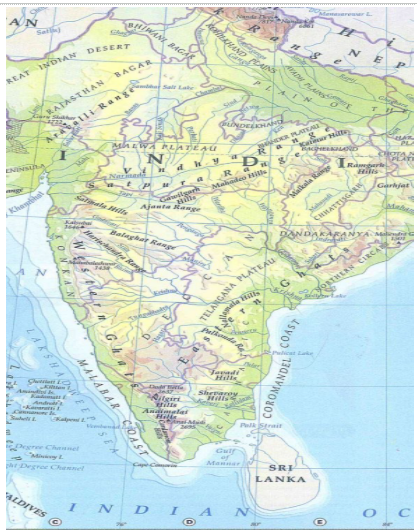
- Aravalli Range: The Aravalli Range is one of India's oldest mountain systems and extends broadly from Rajasthan towards Haryana, Delhi and Gujarat. Important features include:
- highly eroded and discontinuous relief;
- ancient geological formations;
- influence on regional drainage;
- mineral-rich areas;
- important forest ecosystems; and
- Guru Shikhar as its highest peak.
- Vindhya Range: The Vindhya Range is a major central Indian highland system lying broadly north of the Narmada Valley. It is characterised by:
- sandstone formations;
- plateau-like relief;
- Escarpments;
- extensive erosion; and
- connections with the Central Highlands.
- The Vindhyan region forms an important watershed influencing the drainage of central India, including tributaries of the Yamuna.
- Satpura Range: The Satpura Range lies south of the Narmada River and extends across parts of Madhya Pradesh, Maharashtra and adjoining regions. Important components include
- Mahadeo Hills
- Maikal Range
- Gawilgarh Hills
- Rajpipla Hills
- Dhupgarh, near Pachmarhi, is the highest point of the Satpura Range.
- The Satpura system consists of dissected uplands and ranges and forms an important part of the Central Indian highlands.
- Maikal Range: The Maikal Range forms the eastern part of the Satpura system and extends into Madhya Pradesh and Chhattisgarh. It is significant for
- forest ecosystems;
- tribal livelihoods;
- river sources;
- biodiversity; and
- its connection with Chhattisgarh and the eastern highlands.
Mountain Ranges of India in Southern and Peninsular India
The southern Peninsular mountain system consists primarily of the Western Ghats, Eastern Ghats and their associated hill ranges, many of which are ancient, discontinuous and highly eroded.
| Region | Range / Hills | Major States | Important Peak / Feature |
|
Western Ghats |
Sahyadri / Western Ghats |
Maharashtra, Goa, Karnataka, Kerala, Tamil Nadu |
Continuous mountain chain along western India |
|
Western Ghats |
Sahyadri Range |
Maharashtra |
Kalsubai Peak – the highest peak of the Sahyadri at 1,646m |
|
Western Ghats |
Nilgiri Hills |
Tamil Nadu, Kerala, Karnataka |
Meeting point of the Western and Eastern Ghats |
|
Western Ghats |
Anamalai Hills |
Kerala, Tamil Nadu |
Anamudi – 2,695 m |
|
Western Ghats |
Cardamom Hills |
Kerala, Tamil Nadu |
Southern Western Ghats |
|
Western Ghats |
Palani Hills |
Tamil Nadu |
Kodaikanal region |
|
Western Ghats |
Baba Budan Hills |
Karnataka |
Coffee-growing region |
|
Western Ghats |
Biligiriranga Hills (BR Hills) |
Karnataka |
Important ecological corridor |
|
Western Ghats |
Agasthyamalai Hills |
Kerala, Tamil Nadu |
Important biodiversity region |
|
Western Ghats |
Mahabaleshwar Hills |
Maharashtra |
Important hill region and source area of rivers |
Western Ghats
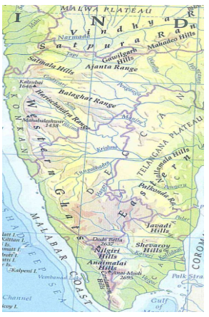
- The Western Ghats run parallel to India's western coast for about 1,600 km, crossing Gujarat, Maharashtra, Goa, Karnataka, Kerala and Tamil Nadu. UNESCO recognises the region for its exceptional biodiversity, endemism and geomorphological importance.
- The Western Ghats are interrupted by the Palghat Gap and contain important peaks, forests, rivers and biodiversity-rich landscapes. UNESCO describes them as one of the world's major biodiversity hotspots and notes the presence of at least 325 globally threatened species. The Western Ghats are also called:
- Sahyadri in Maharashtra;
- Sahya Parvatam in parts of southern India.
- They are higher and more continuous than the Eastern Ghats, with elevations generally ranging between about 900 and 1,600 m. Important Ranges and Hills of the Western Ghats
- Sahyadri: The northern section of the Western Ghats, running mainly through Maharashtra and Goa and forming a prominent mountain barrier along the west coast.
- Nilgiri Hills: Located at the meeting point of the Western and Eastern Ghats, these hills include Doddabetta, the highest peak of the Nilgiris.
- Anaimalai Hills: A high mountain range in Kerala and Tamil Nadu, containing Anamudi, the highest peak in South India and the highest peak of the Western Ghats.
- Cardamom Hills: Situated in southern Kerala and Tamil Nadu, these hills are known for their high rainfall, forests and spice cultivation. The hills are named after the extensive cultivation and natural growth of cardamom (Elettaria cardamomum) in the region.
- Agasthyamalai Hills: Located in the southern Western Ghats along Kerala–Tamil Nadu, they are recognised for rich biodiversity and endemic species.
- Kudremukh Hills: Located in Karnataka, these forested highlands are known for their distinctive horse-face-shaped landscape, biodiversity and iron-ore-bearing formations.
Eastern Ghats
The Eastern Ghats form a discontinuous mountain system along India's eastern side
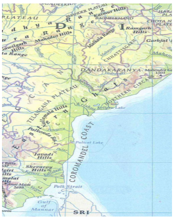
| Region | Range / Hills | Major States | Important Peak / Feature |
|
Eastern Ghats |
Eastern Ghats |
Odisha, Andhra Pradesh, Telangana, Tamil Nadu, Karnataka |
|
|
Eastern Ghats |
Mahendragiri Hills |
Odisha |
Mahendragiri, Jindhagada, etc. |
|
Eastern Ghats |
Nallamala Hills |
Andhra Pradesh, Telangana |
Major hill system |
|
Eastern Ghats |
Palkonda Hills/Range |
Andhra Pradesh |
Southern Eastern Ghats |
|
Eastern Ghats |
Javadi Hills |
Tamil Nadu |
Eastern Tamil Nadu |
|
Eastern Ghats |
Shevaroy Hills |
Tamil Nadu |
Yercaud region |
|
Eastern Ghats |
Pachamalai Hills |
Tamil Nadu |
Eastern Tamil Nadu |
|
Eastern Ghats |
Kolli Hills |
Tamil Nadu |
Namakkal region |
|
Eastern Ghats |
Seshachalam Hills |
Andhra Pradesh |
Tirumala–Tirupati region |
|
Eastern Ghats |
Velikonda Range |
Andhra Pradesh |
Eastern Andhra Pradesh |
|
Eastern Ghats |
Palkonda Hills/Range |
Andhra Pradesh |
Part of the Southern Eastern Ghats |
Major Ranges and Hills of the Eastern Ghats
- Nallamala Hills: A prominent range in Andhra Pradesh and Telangana, known for dense forests and rugged terrain.
- Palkonda Hills/Range: A discontinuous hill range in Andhra Pradesh, forming part of the southern Eastern Ghats.
- Velikonda Range: A north–south trending range in Andhra Pradesh, separating the coastal plains from the interior plateau.
- Javadi Hills: Low, forested hills located mainly in northern Tamil Nadu, forming part of the southern Eastern Ghats.
- Mahendragiri Hills: A prominent hill system in southern Odisha, forming one of the important highlands of the Eastern Ghats.
- Simhachalam Hills: A hill range near Visakhapatnam in Andhra Pradesh, forming part of the Eastern Ghats landscape.
Mountain Ranges of India in the Eastern and Northeastern Peninsulas
The eastern extension of the Peninsular highlands includes the Rajmahal Hills, Meghalaya Hills and Karbi Anglong, which have distinctive geological and ecological characteristics.
Meghalaya and Northeastern Plateau Hills
| Region | Hill / Range | State | Significance |
|
Meghalaya Plateau |
Garo Hills |
Meghalaya |
Western part of Meghalaya |
|
Meghalaya Plateau |
Khasi Hills |
Meghalaya |
Central Meghalaya |
|
Meghalaya Plateau |
Jaintia Hills |
Meghalaya |
Eastern Meghalaya |
|
Meghalaya Plateau |
Tura Hills |
Meghalaya |
Associated with Garo Hills |
|
Northeast Plateau |
Karbi Anglong Hills / Plateau |
Assam |
Northeastern extension of the Peninsular Plateau |
|
Northeast Plateau |
North Cachar Hills |
Assam |
Hilly plateau region |
- Rajmahal Hills: The Rajmahal Hills occur in Jharkhand and represent the eastern extension of the Central Highlands. They are associated with:
-
- plateau landscapes;
- basaltic geological formations in parts;
- forest ecosystems; and
- the transition towards the Ganga plains.
- The region is mineral-rich and receives heavy monsoon rainfall, which has contributed to extensive erosion.
Mountain Ranges of India and Island Mountains & Hill Systems
India features distinct island and hill systems, which are described below.
| Region | Mountain/Hill System | Location | Important Peak / Feature |
|
Andaman Islands |
Andaman Hills |
Andaman Islands |
Hilly island terrain |
|
Andaman Islands |
Saddle Peak Hills |
North Andaman |
Saddle Peak – highest point of Andaman & Nicobar Islands |
|
Nicobar Islands |
Great Nicobar Hills |
Great Nicobar |
Mountainous island terrain |
|
Nicobar Islands |
Mount Thullier Hills |
Great Nicobar |
Important highland of Nicobar |
Mountain Ranges of India and Highest Mountain Peaks
From the snow-capped young fold mountains in the far north to ancient relict blocks in the peninsula, the mountain ranges of India host some of the highest summits on the planet.
- K2 (Mount Godwin-Austen) – 8,611 m: The second-highest mountain in the world, located in the Karakoram; it lies in the part of the Kashmir region.
- Kangchenjunga – 8,586 m: The highest peak after K2 and located on the India–Nepal international boundary, with its Indian side in Sikkim.
- Anamudi – 2,695 m: The highest peak in South India and the highest peak of the Western Ghats.
- Doddabetta – 2,637 m: The highest peak of the Nilgiri Hills in Tamil Nadu.
- Guru Shikhar – 1,722 m: The highest peak of the Aravalli Range, located in Rajasthan.
- Dhupgarh – about 1,350 m: The highest point of the Satpura Range, located near Pachmarhi in Madhya Pradesh.
- Saramati – about 3,840 m: The highest peak of Nagaland, situated near the India–Myanmar border.
- Phawngpui (Blue Mountain) – about 2,157 m: The highest peak of Mizoram, located in the southeastern part of the state.
Mountain Ranges in India Importance
The importance of mountain ranges in India extends from climate regulation and water security to biodiversity conservation, agriculture, energy, tourism, livelihoods and national security.
- Climate and monsoon: The Himalayas act as a major climatic barrier, while the Western Ghats intercept moisture-bearing southwest monsoon winds and strongly influence rainfall distribution.
- River systems and water security: The mountains are important sources of major rivers and their tributaries. Western Ghats rivers include important peninsular river systems, while the Himalayas sustain major perennial river basins.
- Biodiversity: Mountain ecosystems provide altitudinal habitats ranging from tropical forests to alpine environments. The Western Ghats are especially important for endemic biodiversity.
- Agriculture: Mountain slopes, valleys and adjoining plains support diverse crops, horticulture, plantations and pastoral activities.
- Mineral resources: Several Peninsular mountain systems contain economically important deposits of iron ore, manganese, limestone, coal and other minerals.
- Tourism: Mountain landscapes support trekking, pilgrimage, hill stations, adventure tourism, wildlife tourism and cultural tourism.
- National security: The Himalayan and northeastern mountain systems form strategically important frontier regions along India's international boundaries.
- Cultural significance: Mountain ranges are associated with pilgrimage centres, indigenous communities, traditional livelihoods, sacred landscapes and historical routes.
Mountain Ranges in India Major Challenges and Threats
Major threats to India's mountain ranges arise from climate change, deforestation, mining, infrastructure expansion, natural hazards, tourism pressure and unsustainable resource use.
- Climate change: Rising temperatures can alter snow cover, glaciers, water availability, ecosystems and species distribution, particularly in the Himalayas.
- Landslides and erosion: Steep slopes, intense rainfall, earthquakes, road construction and vegetation loss increase slope instability in vulnerable mountain regions.
- Unplanned infrastructure: Roads, tunnels, hydropower projects, settlements and other construction can disturb fragile slopes and natural drainage when geological and ecological constraints are inadequately considered.
- Mining and quarrying: Mining and quarrying can fragment habitats, remove vegetation, destabilise slopes and alter drainage.
- Deforestation: Loss of forests reduces soil stability, biodiversity and water-retention capacity.
- Unsustainable tourism: Rapid tourism growth can generate waste, increase water demand, intensify construction and place pressure on fragile ecosystems.
- Biodiversity loss: Habitat fragmentation, invasive species, forest degradation and changing climatic conditions threaten mountain biodiversity.
- Seismic hazards: The Himalayas are highly seismically active, while parts of the Peninsular region also experience intraplate earthquakes associated with ancient faults and lineaments.
- Water stress: Changes in precipitation, glacier and snow dynamics, groundwater extraction and increasing demand can create water-security challenges.
Mountain Ranges in India Way Forward
The way forward for India's mountain ranges requires region-specific planning that combines ecological conservation, disaster resilience, sustainable livelihoods and scientifically informed infrastructure development.
- Adopt mountain-specific planning: Development strategies should reflect the carrying capacity and geological characteristics of individual mountain regions.
- Strengthen hazard mapping: Landslide, earthquake, avalanche, flood and erosion-prone zones should be scientifically mapped before major infrastructure projects.
- Promote sustainable infrastructure: Roads, tunnels, hydropower and urban expansion should incorporate slope stability, drainage and cumulative environmental assessments.
- Protect forests: Native forests, wetlands, alpine meadows, shola ecosystems and other sensitive habitats should receive stronger protection.
- Regulate mining and quarrying: Extraction should be restricted in ecologically and geologically fragile zones, with effective restoration of degraded areas.
- Promote responsible tourism: Carrying capacity, waste management, water availability and local participation should guide tourism development.
- Strengthen watershed management: Springs, catchments, wetlands and traditional water systems should be restored to improve mountain water security.
- Build climate resilience: Glacier monitoring, early-warning systems, climate-resilient agriculture and disaster preparedness should be strengthened.
- Support mountain communities: Local and indigenous communities should receive livelihood opportunities linked to sustainable agriculture, forestry, handicrafts and responsible tourism.
- Improve scientific monitoring: Remote sensing, GIS, geological surveys and long-term ecological monitoring should guide mountain management.
- Conserve biodiversity corridors: Fragmented habitats should be connected through ecological corridors and landscape-level conservation.
- Integrate local knowledge: Traditional knowledge of mountain communities should complement modern geological, ecological and disaster-management approaches.
Mountain Ranges in India UPSC PYQs
Q1. Consider the following statements: (UPSC Prelims 2023)
- Amarkantak Hills are at the confluence of Vindhya and Sahyadri Ranges
- Biligirirangan Hills constitute the easternmost part of Satpura Range
- Seshachalam Hills constitute the southernmost part of Western Ghats
How many of the above statements are correct?
a) Only one
b) Only two
c) All three
d) None
Ans: (d)
Q2. Consider the following pairs: (UPSC Prelims 2022)
| Peak | Mountains |
|
1. Namcha Barwa |
Garhwal Himalaya |
|
2. Nanda Devi |
Kumaon Himalaya |
|
3. Nokrek |
Sikkim Himalaya |
Which of the pairs given above is/are correctly matched?
a) 1 and 2
b) 2 only
c) 1 and 3
d) 3 only
Ans: (b)
Q3. Consider the following pairs: Hills Region: (UPSC Prelims 2014)
- Cardamom Hills: Coromandel Coast
- Kaimur Hills: Konkan Coast
- Mahadeo Hills: Central India
- Mikir Hills: North-East India
Which of the above pairs are correctly matched?
a) 1 and 2
b) 2 and 3
c) 3 and 4
d) 2 and 4
Ans: (c)

 Last updated on Sep, 2026
→ UPSC 2027 Notification will be released on 13 January 2027 at upsconline.nic.in.
→ Asian Games 2026 are being held in Aichi-Nagoya, Japan, from 19 September to 4 October.
→ Check out the latest UPSC Syllabus here.
→ Download UPSC Model Answers for Mains 2026
→ UPSC Mains Question Paper 2026 is out now for Essay & GS Paper 1, 2, 3 & 4.
→ UPSC Calendar 2027 has been released.
→ Enroll in Vajiram & Ravi’s UPSC Mains Test Series 2027 for structured answer writing practice, expert evaluation, and exam-oriented feedback.
→ Join Vajiram & Ravi’s UPSC Mentorship Program 2027 for personalized guidance, strategy planning, and one-to-one support from experienced mentors.
→ Go through the UPSC Mains Previous Year Papers to enhance your preparation.
→ UPSC has released UPSC Toppers List 2025 with the Civil Services final result on its official website.
→ Also check Best UPSC Coaching in India
Mountain Ranges in India FAQs
Q1. What is the height of K2?+
Q2. Which is the highest peak of India?+
Q3. Which is the highest peak of the Peninsular Plateau?+
Q4. Which is the highest peak of the Satpura Range?+
Q5. Which mountain peak is called the Blue Mountain of Mizoram?+
Tags: mountain ranges in india quest UPSC Geography Notes