Red-Shanked Douc Monkey

Red-Shanked Douc Monkey

Red-Shanked Douc Monkey Latest News

Recently, customs officials at the Kempegowda International Airport (KIA) arrested a passenger who was smuggling two red-shanked douc monkeys.

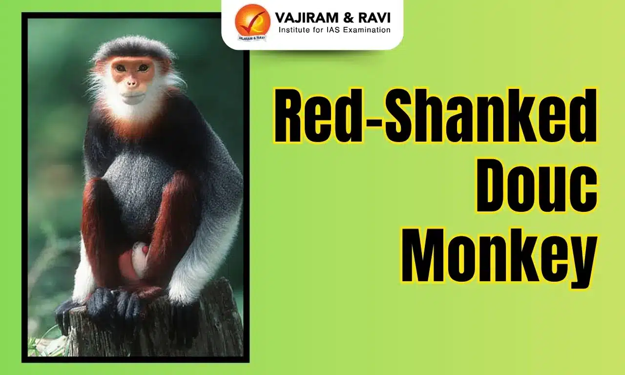
About Red-Shanked Douc Monkey

  • The Red-shanked douc (Pygathrix nemaeus) is an Old World monkey which is considered as a “Queen of primates”.
  • Habitat: They occur in subtropical and tropical broadleaf evergreen or semi-deciduous forests and to a lesser extent in secondary evergreen and mixed bamboo forests.
  • Distribution: Red-shanked doucs are found in Southeast Asia mainly in Vietnam, Southern Laos and Cambodia.

Characteristics of Red-Shanked Douc Monkey

  • Appearance: It is referred to as “the costumed ape,” the red-shanked douc langur is among the most colorful of primates. 
  • These are arboreal, herbivores and diurnal monkeys that eat and sleep in the trees of the forest.
  • Communication: They communicate with each other using various facial expressions.
  • Conservation Status: IUCN: Critically Endangered 
  • Threats: Hunting is the main threat – for subsistence use and traditional medicine – they are also hunted for the international pet trade. 

Source: TH

Red-Shanked Douc Monkey FAQs

Q1: What is the scientific name of the Red-Shanked Douc Monkey?

Ans: Pygathrix nemaeus

Q2: What is distinctive about the Red-Shanked Douc Monkey's appearance?

Ans: Red legs and hands

Dandami Madia Tribe

Dandami Madia Tribe

Dandami Madia Tribe Latest News

Recently, members of the Dandami Madia tribe perform the traditional Bison Horn Maria dance during a village festival at Judiya Para in Jagdalpur.

About Dandami Madia Tribe

  • Dandami Maria, also known by other names like Bison Horn Maria and Khalpati Maria.
  • It is a tribal community which lives in Chhattisgarh.
  • They have derived their name from their unique custom of wearing a distinctive head-gear, which resembles the horns of a wild bison.
  • They generally wear that head-gear during ceremonies.
  • They identify themselves as part of the larger Gond tradition.
  • Language: The main distinct language spoken by this tribe is Dandami Maria. Some of them speak Gondi dialects, which is an oral language of Dravidian origins.

Society and Customs of Dandami Madia Tribe

  • Economy: They live by agriculture, supplemented by hunting and fishing.
  • Belief: Their belief is a combination of Hinduism with Animistic beliefs.
  • Their ghotul (youth dormitory for unmarried boys and girls) is an important social institution.
  • They permit divorce and widow remarriage.
  • They perform the traditional Bison Horn Maria dance during a village festival. It is performed by both men and women.

Source: TH

Dandami Madia Tribe FAQs

Q1: In which state is the Dandami Madia Tribe primarily found?

Ans: Chhattisgarh

Q2: What is the primary language spoken by the Dandami Madia Tribe?

Ans: Gondi

Perumbidugu Mutharaiyar

Perumbidugu Mutharaiyar

Perumbidugu Mutharaiyar Latest News

Recently, a commemorative postage stamp in honour of the king Perumbidugu Mutharaiyar II (Suvaran Maran) was released by the Vice President of India. 

About Perumbidugu Mutharaiyar

  • Perumbidugu Mutharaiyar (705 AD-745 AD), also known as Suvaran Maran, was a ruler of the Mutharaiyar lineage.
  • Suvaran Maran was also known as Shatrubhayankar.
  • Perumbidugu Mutharaiyar is believed to have fought bravely in several battles alongside the Pallava king Nandivarman, and is remembered as a great administrator.
  • He seems to have patronised Shaivya and other scholars, as a Jain monk Vimalachandra is mentioned as visiting his court to debate them.

Who are Mutharaiyars?

  • They were the feudatories of the Pallavas.
  • As the Pallavas’ rule weakened, many such chiefs earned more power and prominence and were treated as rulers in their own right.
  • The Mutharaiyars held sway over areas including Thanjavur, Pudukkottai, Perambalur, Tiruchirappalli, and others near the Cauvery river.
  • As the feudatories of the Pallavas, the Mutharaiyars were great temple builders.
  • Muttarayars were engaged in cave temple enterprises up to the opening decades of the ninth century.

Source: IE

Perumbidugu Mutharaiyar FAQs

Q1: Who was Perumbidugu Mutharaiyar?

Ans: A Mutharaiyar king

Q2: What was Perumbidugu Mutharaiyar's other name?

Ans: Suvaran Maran

Moei River

Moei River

Moei River Latest News

Promises of data-entry jobs drew young men from the State of Gujarat across the Moei River into Myanmar’s alleged cyber-fraud compounds.

About Moei River

  • The Moei River, known in Myanmar as the Tonge Yin River, is an important river in northern Thailand.
  • It is a tributary of the Salween River.
  • SourceOriginates in the Tenasserim Hills (Myanmar–Thailand border region)
  • Unlike most rivers in Thailand, the Moei River flows north in a northwest direction.
  • It stretches approximately 327 kilometers, flowing from the south to the north of Thailand before joining the Salween River in Myanmar. 
  • This river serves as a natural border between Thailand and Myanmar.
  • Key Towns Along the River:
    • Mae Sot (Thailand)
    • Myawaddy (Myanmar)
  • Historically, the Moei River was a key waterway for communication and transporting goods between Thai and Burmese communities.

Source: TH

Moei River FAQs

Q1: Which two countries does the Moei River form a natural boundary between?

Ans: Thailand and Myanmar

Q2: The Moei River is a tributary of which major river?

Ans: Salween River

Q3: Where does the Moei River originate from?

Ans: Tenasserim Hills (Myanmar–Thailand border region)

Q4: Approximately how long is the Moei River?

Ans: 327 kilometers

Chakrashila Wildlife Sanctuary

Chakrashila Wildlife Sanctuary

Chakrashila Wildlife Sanctuary Latest News

Community-led conservation efforts at the Chakrashila Wildlife Sanctuary have successfully restored wild honey bee colonies and revitalized associated wildlife.

About Chakrashila Wildlife Sanctuary

  • It is locatеd in thе Kokrajhar and Dhubri districts of Assam.
  • The sanctuary is well-known as the second protected habitat for the endangered golden langur, hosting over 600 individuals.
  • It spans over 45.5 sq.km. of hilly tеrrain and dеnsе forеsts.
  • There are two lakes (Dheer Beel and Diplai Beel) on either side, which are integral to the ecosystem of the sanctuary. 
  • Flora
    • The vegetation of the sanctuary is predominantly tropical moist deciduous forests, mixed deciduous forests, and semi-evergreen forests.
    • Sal tree is a dominant tree in this forest.
  • Fauna:
    • It is home to various species, including elephants, tigers, leopards, clouded leopards, sambar deer, barking deer, and gaur. 
    • The sanctuary is also home to several species of birds, including the endangered Bengal Florican, Great Hornbill, and White-winged Wood Duck.

Source: SENT

Chakrashila Wildlife Sanctuary FAQs

Q1: Chakrashila Wildlife Sanctuary is located in state?

Ans: Assam

Q2: Chakrashila Wildlife Sanctuary is especially known for being the protected habitat of which endangered species?

Ans: Golden Langur

Q3: What is the approximate area of Chakrashila Wildlife Sanctuary?

Ans: It spans over 45.5 sq.km. of hilly tеrrain and dеnsе forеsts.

Q4: What is the dominant vegetation type of Chakrashila Wildlife Sanctuary?

Ans: Tropical moist deciduous and mixed deciduous forests

Man-Portable Air Defence Systems (MANPADS)

Man-Portable Air Defence Systems (MANPADS)

Man-Portable Air Defence Systems (MANPADS) Latest News

The Indian Army is undertaking a major strategic shift in its air defence operations, repurposing its Man-Portable Air Defence Systems (MANPADS) to specifically counter the rising threat of sub-sonic cruise missiles.

About Man-Portable Air Defence Systems (MANPADS)

  • MANPADS are surface-to-air missiles that can be fired by an individual or a small team of people against aircraft.
  • These weapon systems often are described as shoulder-fired anti-aircraft missiles. 
  • MANPADS are generally less than 2 metres in length and weigh around 20 kg. 
  • The United States and the Soviet Union first deployed MANPADS—the Redeye and Strela systems, respectively—in the 1960s to provide their infantries with portable anti-aircraft weapons. 
  • The militaries of about 105 countries across the world operate MANPADS, although only 12 countries, including India, produce them. 
  • The most famous MANPADS are the US-made ‘Stinger’ and the Soviet 9K32 Strela-2, or simply ‘SA-7' with the China-made ‘FN-16’ being the latest entrant. 
  • Three general types of MANPADS exist: command line of sight, laser guided, and infrared seekers.
    • Command line-of-sight MANPADS are guided to their targets through the use of a remote control. 
    • Laser-guided or laser beam rider MANPADS follow a laser projected onto the target. 
    • The most common MANPADS, frequently called heat seeking missiles, however, are infrared seekers that acquire their target by detecting the heat of an aircraft’s engine.
  • Most MANPADS consist of: 
    • a missile packaged in a tube; 
    • a launching mechanism (commonly known as a “gripstock”); and 
    • a battery

Source: DEF

Man-Portable Air Defence Systems (MANPADS) FAQs

Q1: What are MANPADS?

Ans: Surface-to-air missile systems that can be fired by an individual or a small team against aircraft.

Q2: What is the typical length of a Man-Portable Air Defence Systems (MANPADS) missile?

Ans: Generally less than 2 metres.

Q3: Which two countries first deployed Man-Portable Air Defence Systems (MANPADS) in the 1960s?

Ans: The United States and the Soviet Union.

Q4: How many countries worldwide operate Man-Portable Air Defence Systems (MANPADS)?

Ans: The militaries of about 105 countries across the world operate MANPADS.

Q5: What are the three general types of Man-Portable Air Defence Systems (MANPADS) based on guidance?

Ans: Command line-of-sight, laser-guided, and infrared seeker MANPADS.

Bluebird 6 Satellite

Bluebird Satellite

Bluebird 6 Satellite Latest News

The Indian Space Research Organisation (ISRO) is scheduled to launch the US-based commercial BlueBird-6 satellite developed by US-based AST Spacemobile on 21st December 2025 using ISRO’s LVM-3 rocket.

About Bluebird 6 Satellite

  • Purpose: Designed to provide direct-to-device internet connectivity, enabling mobile phones to access broadband without relying on traditional cell towers.
  • Origin: Developed by the US-based commercial company AST SpaceMobile for global mobile coverage.
  • Weight and Size: Weighs around 6.5 tonnes, making it one of the heaviest satellites launched by ISRO.
  • Orbit Type: Will operate in low-Earth orbit (LEO) to cover large regions of the Earth efficiently.
  • Technology: Features one of the largest phased array antennas ever flown, which covers nearly 2,400 square feet, allowing it to communicate directly with standard mobile phones.
  • Significance: It enhances global mobile broadband connectivity, especially in remote and rural areas.
  • Collaboration: Represents a significant step in Indo-US space cooperation and commercial space ventures.
  • Future Impact: Expected to help bridge the digital divide, providing internet access to regions without cellular infrastructure.

About LVM-3

  • LVM-3, also known as GSLV Mk III or “Bahubali”, is a heavy-lift launch vehicle developed by ISRO.
  • It is designed to carry large satellites into space and support human spaceflight missions.
  • The rocket is approximately 43.43 meters tall and has a lift-off mass of around 640 tonnes, making it India’s heaviest launch vehicle.
  • It can carry up to 4 tonnes to Geostationary Transfer Orbit (GTO) and 10 tonnes to Low Earth Orbit (LEO).
  • It is a three-stage rocket: two solid rocket boosters (S200), a liquid core stage (L110), and a cryogenic upper stage (C25).
  • It has been used for heavier communication satellites, interplanetary missions, and India’s Gaganyaan human spaceflight project.
  • Its first successful experimental flight was in December 2014, and it is known for its reliability and heavy payload capability.

Source: ToI

Bluebird Satellite FAQs

Q1: Who developed the Bluebird satellite?

Ans: It was developed by the U.S.-based AST SpaceMobile.

Q2: What is the primary purpose of the Bluebird satellite?

Ans: Direct smartphone communication from space.

Q3: What is the approximate weight of the Bluebird satellite?

Ans: 6,000 kg

Q4: In which type of Earth orbit will the Bluebird satellite operate?

Ans: Low Earth Orbit (LEO)

Key Facts About Jordan

Key Facts about Jordan

Jordan Latest News

Recently, the Prime Minister of India has embarked on a three-nation visit to Jordan, Ethiopia and Oman.

About Jordan

  • Location: It is a landlocked country located in the rocky desert of the northern Arabian Peninsula.
  • Bordering Countries: It is bordered by 5 Nations: Syria in the north, Iraq in the east, Saudi Arabia in the south and southeast and Israel and Palestine in the west.
  • Water bodies: Dead Sea, the Gulf of Aqaba and the Sea of Galilee.
    • The Dead Sea is located along the western borders of the country.
  • Ports: Al-Aqabah, the only port of Jordan is located in the south-western part of the country along the coasts of the Gulf of Aqaba.
  • Capital City: Amman

Geographical Features of Jordan

  • Terrain: It has arid desert plateau; a great north-south geological rift along the west of the country is the dominant topographical feature.
  • Highest Point: Jabal Umm ad Dami is the highest point of Jordan.
  • Rivers: The Jordan River which drains into the Dead Sea.
  • Natural Resources: It mainly consists of phosphates, potash and shale oil.

Source: DD News

Jordan FAQs

Q1: Which river forms part of Jordan's western border?

Ans: Jordan River

Q2: Which ancient city is a UNESCO World Heritage Site in Jordan?

Ans: Petra

Gulf of Oman

Gulf of Oman

Gulf of Oman Latest News

Iran recently seized an oil tanker in the Gulf of Oman, Iranian media said recently, adding that 18 crew members from India, Sri Lanka, and Bangladesh were on board.

About Gulf of Oman

  • The Gulf of Oman, also known as the Gulf of Makran, is the northwest arm of the Arabian Sea.
  • It forms the only entrance to the Persian Gulf from the Indian Ocean.
  • It covers an area spanning 115,000 sq.km. 
  • It connects the Arabian Sea with the Strait of Hormuz, which then empties into the Persian Gulf.
  • Bordering Countries: It is bordered by Pakistan and Iran in the north, by the United Arab Emirates in the west, and by Oman in the south.
  • The gulf is about 320 km wide at its widest point between Cape al-Hadd in Oman and Gwadar Bay on the Iran-Pakistan border. It narrows to 35 miles (56 km) at the Strait of Hormuz.
  • It is approximately 560 km long.
  • The gulf is relatively shallow because of its origin as a fissure in the mountain spine now divided between Iran and Oman. 
  • Some of the significant islands that are located in the Gulf of Oman include Sheytan Island, Al Fahal Island, Dimaniyat Islands, and the Sawadi Islands.
  • The major international shipping ports that are situated in the Gulf of Oman include Port Sultan Qaboos Muttrah in Muscat, Oman; Chabahar Port in Iran; the Port of Fujairah and Khor Fakkan Container Terminal in the United Arab Emirates.
  • Roughly one-third of the world’s oil is exported via the Strait of Hormuz and the Gulf of Oman.

Source: TH

Gulf of Oman FAQs

Q1: What is the Gulf of Oman also known as?

Ans: Gulf of Makran

Q2: The Gulf of Oman is the northwest arm of which sea?

Ans: Arabian Sea

Q3: Which water body connects the Gulf of Oman to the Persian Gulf?

Ans: Strait of Hormuz

Q4: Which countries border the Gulf of Oman?

Ans: Pakistan and Iran (north), United Arab Emirates (west), and Oman (south).

Dieback Disease

Dieback Disease

Dieback Disease Latest News

The withering of thousands of neem trees over some years had prompted the Mulugu-based Forest College & Research Institute (FCRI), to launch a comprehensive scientific probe into the devastating "dieback disease."

About Dieback Disease

  • It is a fungal disease which kills a wide variety of plants.
  • It is responsible for causing wilting and browning of leaves from the tip of the branch, stem canker, and fruit rot.
  • It was first reported in the country during the 1990s near Dehradun in Uttarakhand.
  • The dieback fungus belongs to the genus Phytophthora
  • Mode of spread: 
    • The fungus is spread through the movement of soil and mud, especially by vehicles and footwear. 
    • It also moves in free water and via root-to root contact between plants.
  • The fungus lives in susceptible plant tissue and soil, and migrates and reproduces in warm, moist conditions. 
  • Infected roots cannot provide the water and nutrients needed to maintain life, and the plants die from dehydration.
  • It causes almost 100% loss of fruit production in severely infected trees.
  • Where the disease occurs, the native vegetation can become devastated, and the delicate fabric of ecosystems seriously impaired; certain species can disappear from the area.
  • The appearance of symptoms starts with the onset of the rainy season and becomes progressively severe in the later part of the rainy season and early winter.
  • Dieback is not easy to detect, as infected plants often appear to be dying from drought.
  • There is no known cure for the disease.

Source: DC

Dieback Disease FAQs

Q1: Dieback disease is caused by which type of pathogen?

Ans: Fungus

Q2: What is the common symptom of dieback disease?

Ans: Browning of leaves from the tip of the branch.

Q3: Why is dieback disease often difficult to detect in its early stages?

Ans: Infected plants appear similar to drought stress

Q4: Where was dieback disease first reported in India?

Ans: Near Dehradun in Uttarakhand.

Ramappa Temple

Ramappa Temple

Ramappa Temple Latest News

Recently, ambassador and Permanent Representative of India to UNESCO-Paris visited the Ramappa Temple and reviewed the preservation and conservation efforts undertaken by the Archaeological Survey of India (ASI) and the State government.

About  Ramappa Temple

  • It is located in the state of Telangana.
  • It was constructed in 1213 AD during the reign of the Kakatiya Empire by RecharlaRudra, a general of Kakatiya king Ganapati Deva.
  • The presiding deity here is RamalingeswaraSwamy.
  • It is also known as the Rudreswara Temple.
  • The temple got its name Ramappa because of its chief sculptor Ramappa.
  • Ramappa Temple is probably the only temple in India that is named after the architect.

Architectural Features of Ramappa Temple

  • The temple stands on a 6 feet high star-shaped platform with walls, pillars and ceilings adorned with intricate carvings.
  • Earthquake-proof: Made out of clay mixed with acacia wood, chaff and myrobalan fruit (a family of amla), the bricks used in building the gopuram of the temple are light enough to float on water.
    • Using this technique has made the temple light, meaning, in case of a natural event like an earthquake, the probability of it collapsing would be very low.
  • Sandbox technique: The temple construction was done using the sandbox technique. This is a technique where the foundation pit is filled with a mixture of sand-lime, jaggery and black myrobalan fruit.
  • This mix acts as a cushion in case of earthquakes. 
  • In 2021, the temple was inscribed as a UNESCO World Heritage Site as “Kakatiya Rudreshwara (Ramappa) Temple, Telangana”.

 Source: TH

Ramappa Temple FAQs

Q1: When was the Ramappa Temple built?

Ans: 13th century

Q2: What is the architectural style of Ramappa Temple?

Ans: Kakatiya

Enquire Now