Kawtchhuah Ropui is a major archaeological site located near Vangchhia village in Champhai district of Mizoram, close to the India-Myanmar border. The term means “The Great Entranceway” in the Mizo language. It is spread across nearly 45 square kilometres in the Lower Himalayan belt. The site preserves evidence of an advanced early settlement marked by carved stone monuments and structured habitation zones. It was officially declared Mizoram’s first centrally protected monument by the Archaeological Survey of India in 2012 under the Ancient Monuments and Archaeological Sites and Remains Act 1958, confirming its national importance.
Kawtchhuah Ropui Features
The Kawtchhuah Ropui site reflects a planned ancient settlement with monumental stone art and structural remains.
- Location: Situated in Champhai district along the Indo-Myanmar border zone, the site holds significance for understanding trans-border cultural exchanges and early settlement patterns in Northeast India.
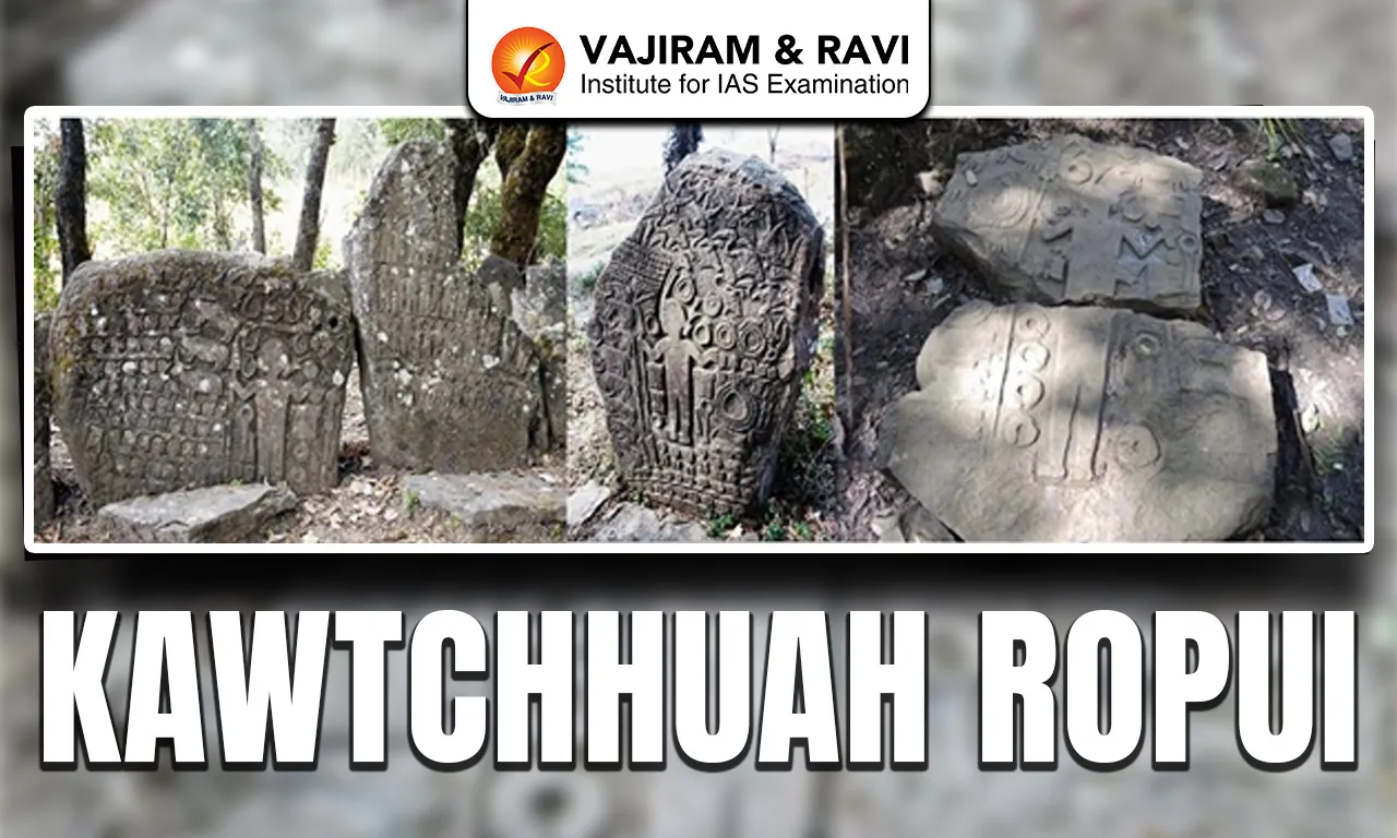
- Menhirs Alignment: Around 170 to 171 standing stones are arranged along an ancient entrance pathway. Several rise nearly 15 feet high and are carved with detailed depictions of humans, animals, floral motifs, weapons, hunting scenes and traditional Mizo musical instruments, showing high artistic skill.
- Engraved Cultural Symbols: Many stones display images of warriors, ceremonial objects and community heroes from local legends. These carvings provide direct visual evidence of early Mizo social traditions, hunting practices and commemorative rituals associated with important individuals.
- Lungdawh Tradition: In Mizo culture, large memorial stones called lungdawh were erected to honour distinguished persons. The scale, density and detailing of monuments at Kawtchhuah Ropui make it one of the most elaborate known stone commemorative complexes in the region.
- Rock-Cut Terraces: Excavations revealed 15 carved rock terraces, indicating planned habitation. These terraces suggest that ancient inhabitants modified sandstone slopes to create stable living platforms, showing knowledge of landscape engineering and settlement planning.
- Necropolis: Archaeologists identified a large necropolis or cemetery zone, within the complex. The presence of burial-related structures indicates a well-organised community with defined mortuary practices and structured spatial planning.
- Water Pavilion Structure: A unique “water pavilion” contains strategically drilled holes ranging from about one foot to one metre in diameter. These holes, cut into sandstone surfaces, were likely used for storing rainwater, demonstrating water management skills.
- Geological Setting: The region consists mainly of steep sandstone hills, varying from light grey to dark blackish shades. The natural rock formations provided suitable material for carving menhirs and constructing terraces and retaining walls.
- Time Period: Initial assessments by the Archaeological Survey of India suggested a 14th to 15th century CE origin. However, pottery remains and nearby Neolithic caves indicate that human occupation in the area may date much earlier.
- Legal Protection: In 2011, the Archaeological Survey of India conducted a formal survey confirming the archaeological value of the site. It was subsequently notified as a monument of national importance under the 1958 Act, ensuring legal protection and conservation oversight.
- Infrastructure Development: The Government of Mizoram allocated approximately ₹5.2 crore for improving access pathways, rest areas and interpretation facilities. These measures aim to promote responsible heritage tourism while preserving archaeological integrity.
Also Read: Sewa Singh Thikriwala
Kawtchhuah Ropui FAQs
Q1: What does Kawtchhuah Ropui mean?
Ans: Kawtchhuah Ropui is a Mizo term meaning “The Great Entranceway.” The name reflects the arrangement of large standing stones aligned like a monumental gateway near Vangchhia village in Champhai district, Mizoram.
Q2: Where is Kawtchhuah Ropui located?
Ans: It is situated near Vangchhia village in Champhai district of Mizoram, close to the India-Myanmar border, within the Lower Himalayan hill region spread over about 45 square kilometres.
Q3: What types of carvings are found on the menhirs at Kawtchhuah Ropui?
Ans: The standing stones feature engravings of human figures, animals, floral patterns, weapons, hunting scenes and traditional Mizo musical instruments, reflecting social life, rituals and artistic expression of the ancient community.
Q4: When was Kawtchhuah Ropui declared a protected monument?
Ans: In 2012, it became Mizoram’s first centrally protected monument under the Archaeological Survey of India, notified under the Ancient Monuments and Archaeological Sites and Remains Act, 1958.
Q5: What period does Kawtchhuah Ropui belong to?
Ans: Initial assessments placed it in the 14th-15th century CE, but discoveries of pottery and nearby Neolithic caves suggest that human occupation in the area may be much older.