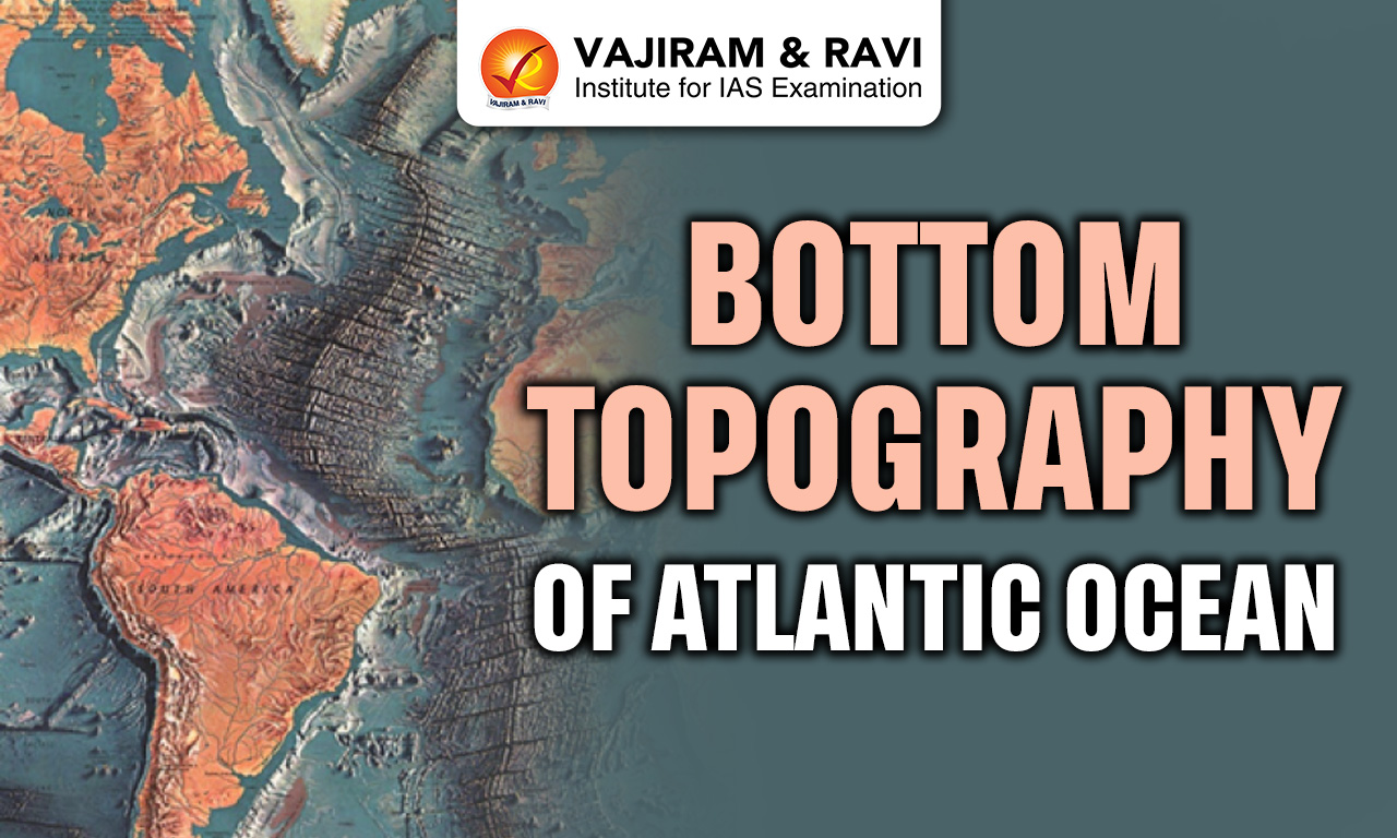
The Atlantic Ocean is the second largest ocean on the earth. It covers about one-fifth of Earth’s surface and separates Europe and Africa from the Americas. It has an S shaped form and extends from the Arctic to the Southern Ocean. Its area is about 81.76 million square km without seas and 85.13 million square km with them. It has an average depth of 3,646 metres and maximum depth of 8,380 metres. The Bottom Topography of Atlantic Ocean plays a vital role in global climate, drainage and human activities.
Bottom Topography of Atlantic Ocean
The Atlantic Ocean floor is highly varied, with an average depth of 3,646 metres and extensive continental margins and basins. The most striking feature is the Mid Atlantic Ridge running centrally. The ocean is relatively shallow compared to the Pacific due to wide continental shelves. About 24% of the area of Bottom Topography of Atlantic Ocean is less than 915 metres deep, reflecting strong sedimentation, gentle slopes and broad abyssal plains.
Atlantic Ocean Zones
The Atlantic Ocean is divided into distinct zones based on depth, light penetration and geomorphological characteristics, each supporting unique physical and biological conditions of the Bottom Topography of Atlantic Ocean.
- Continental Zone: Extends from coastline to shelf edge, usually up to 200 metres depth, receiving sediments from rivers like Amazon and Congo and supporting rich marine biodiversity and fisheries.
- Bathyal Zone: Lies between 200 and 2000 metres depth, covering continental slope regions with steep gradients, submarine canyons and reduced sunlight, making it ecologically transitional.
- Abyssal Zone: Extends from 2000 to 6000 metres depth, forming vast abyssal plains covered with fine sediments such as calcareous ooze and red clay, representing stable deep sea environments.
- Hadal Zone: Found in deep trenches exceeding 6000 metres, such as Puerto Rico Trench, characterized by extreme pressure, darkness and unique geological and biological conditions.


Atlantic Ocean Topographic Divisions
The Bottom Topography of Atlantic Ocean floor is divided into major physiographic units shaped by tectonic processes, sedimentation and crustal movements over millions of years.
- Continental Shelf & Slope: Shallow margins with varying width from 2 km to 400 km, formed by sediment deposition and erosion, acting as transition zones between land and deep ocean.
- Ocean Ridge: The Mid Atlantic Ridge is a continuous mountain chain extending about 14,450 km, marking divergent plate boundaries and seafloor spreading zones.
- Ocean Rises: Broad elevated features such as Walvis Ridge and Rio Grande Rise connect ridge systems to continental margins, influencing ocean circulation and sediment deposition.
- Ocean Basin: Deep depressions divided into eastern and western basins by the ridge, containing several sub basins like Labrador and Brazilian basins.
- Ocean Deep & Trenches: Narrow, steep depressions such as Puerto Rico Trench and Romanche Deep, formed by tectonic activity, reaching depths beyond 8000 metres.
- Abyssal Plains: Extensive flat regions formed by deposition of fine sediments, representing some of the smoothest surfaces on Earth.
Atlantic Continental Shelf & Slope
Continental margins of the Atlantic Ocean are well developed and significantly influence ocean depth, sediment distribution and economic activities such as fishing and resource extraction affecting Bottom Topography of Atlantic Ocean.
- Shelf Width Variation: Continental shelves vary from 2-4 km to over 400 km wide, with wider shelves along northeastern North America and northwestern Europe and narrower shelves along African and Brazilian coasts.
- Major Shelf Regions: Important shelf areas include Grand Bank near Newfoundland and Dogger Bank near British Isles, known for rich fishing grounds and shallow depths.
- Marginal Seas Presence: North Atlantic shelves host marginal seas such as Baltic Sea, North Sea and Hudson Bay, while South Atlantic has fewer such features.
- Continental Slope Characteristics: The slope marks a steep descent from shelf to deep ocean, often cut by submarine canyons transporting sediments into deeper basins.
- Continental Rise Formation: Formed by accumulated sediments at base of slope, reaching depths of 2400-4500 metres and extending up to 500 km wide in some regions.
Mid Atlantic Ridge
Ridges are the most prominent features of Atlantic Ocean floor, reflecting tectonic activity and continuous formation of new oceanic crust.
- Mid Atlantic Ridge Structure: Extends from Iceland to Bouvet Island with an S shaped alignment, about 1000 miles wide, forming the central backbone of the ocean.
- Plate Boundary Role: Represents divergent boundary where American plates move westward and Eurasian and African plates move eastward, causing seafloor spreading.
- Ridge Branches: Includes Newfoundland Rise, Azores Rise, Sierra Leone Rise and Rio Grande Rise, extending toward continents and shaping basin structures.
- Fracture Zones: Major fracture zones like Gibbs, Kane and Romanche offset the ridge and indicate transform fault activity and crustal movements.
- Volcanic Activity: Ridge is volcanically active with basaltic lava formation and seamounts, some rising above sea level forming islands like Iceland and Azores.
Also Read: Bottom Topography of Indian Ocean
Atlantic Ocean Basin
The Atlantic Ocean basin is divided into eastern and western parts by the Mid Atlantic Ridge, containing numerous smaller basins with distinct characteristics.
- Labrador Basin: Located between Greenland and Newfoundland, extending from 40°N to 50°N with depths ranging between 4000 and 4500 metres.
- North American Basin: Largest basin extending between 12°N and 40°N with depths exceeding 5000 metres and some deeps beyond 6000 metres.
- Brazilian Basin: Located between equator and 30°S, bounded by Brazil coast and Para Rise, with depths greater than 4000 metres.
- Canary and Cape Verde Basins: Located near African coast, both reaching depths around 5000 metres and influenced by ocean currents and sedimentation.
- Southern Basins: Include Argentina Basin, Cape Basin and Agulhas Basin with depths ranging between 5000 and 6000 metres, forming major southern depressions.
Atlantic Ocean Deeps & Trenches
Ocean deeps and trenches in the Atlantic are fewer compared to the Pacific but are significant indicators of tectonic activity and structure of Bottom Topography of Atlantic Ocean.
- Puerto Rico Trench: Deepest point at 8380 metres, located north of Puerto Rico, marking a major tectonic boundary and subduction related feature.
- Romanche Deep: One of the deepest equatorial features reaching about 9370 metres, associated with fracture zones and plate movements.
- Hatteras and Nares Deeps: Important deep sea depressions with depths exceeding 5000-6000 metres, found in North Atlantic basin regions.
- South Sandwich Trench: Located in South Atlantic, associated with island arc systems and subduction of South American Plate beneath Scotia Plate.
- Distribution Pattern: Total of about 29 deeps identified, mostly located along island arcs and tectonic boundaries rather than widespread distribution.
Also Read: Bottom Topography of Pacific Ocean
Atlantic Abyssal Plains
Abyssal plains are extensive flat regions of the Bottom Topography of Atlantic Ocean formed by long term sediment deposition and represent stable geological environments.
- Formation Process: Created by accumulation of fine sediments like calcareous ooze and red clay transported by turbidity currents and ocean currents.
- Depth Range: Generally found between 3000 and 6000 metres depth, covering large portions of ocean basins on both sides of Mid Atlantic Ridge.
- Sediment Composition: Dominated by globigerina ooze, diatom ooze in southern latitudes and red clay in deeper regions below 5000 metres.
- Surface Characteristics: Extremely smooth and level surfaces compared to other ocean floor features, with occasional abyssal hills and seamounts.
- Distribution Pattern: More extensive in South Atlantic, especially between Argentina and Africa, while narrower in central and northern regions.
Atlantic Ocean Surface Features
The Bottom Topography of Atlantic Ocean also includes several secondary features such as islands, canyons and seamounts that add complexity to its topography.
- Submarine Canyons: Deep valleys like Hudson Canyon and Amazon Canyon transport sediments from continental shelves to deep ocean basins through turbidity currents.
- Oceanic Islands: Include Iceland, Azores, Canary, Cape Verde, Ascension and Tristan da Cunha formed mainly by volcanic activity or uplifted ridge segments.
- Island Arcs: Lesser Antilles and South Sandwich Islands represent tectonically active arcs associated with subduction zones and deep trenches.
- Seamounts and Guyots: Numerous underwater mountains formed by volcanic processes, some flattened into guyots due to erosion and subsidence.
- Marginal Seas: Caribbean Sea, Mediterranean Sea and Gulf of Mexico are enclosed or semi enclosed basins connected to Atlantic, influencing circulation and sedimentation.
Bottom Topography of Atlantic Ocean Significance
The Bottom Topography of Atlantic Ocean has immense importance in understanding geological processes, climate systems and economic resources.
- Plate Tectonics Evidence: Mid Atlantic Ridge provides clear evidence of seafloor spreading and continental drift, supporting modern geological theories of Earth’s evolution.
- Resource Availability: Continental shelves and rises contain large reserves of petroleum, natural gas and minerals due to thick sediment accumulation.
- Climate Influence: Ocean floor features control deep ocean currents and thermohaline circulation, significantly affecting global climate patterns.
- Marine Biodiversity: Diverse habitats such as ridges, trenches and plains support varied marine ecosystems, including unique deep sea organisms.
- Navigation and Communication: Knowledge of ocean floor helps in laying submarine cables, planning shipping routes and conducting scientific exploration.
![]() Last updated on July, 2026
Last updated on July, 2026
→ UPSC Prelims Result 2026 is now out.
→ UPSC IFoS Prelims Result 2026 is now out.
→ Enroll in Vajiram & Ravi’s UPSC Mains Test Series 2026 for structured answer writing practice, expert evaluation, and exam-oriented feedback.
→ Join Vajiram & Ravi’s UPSC Mentorship Program 2026 for personalized guidance, strategy planning, and one-to-one support from experienced mentors.
→ Join Vajiram & Ravi’s UPSC Mentorship Program 2027 for personalized guidance, strategy planning, and one-to-one support from experienced mentors.
→ UPSC Prelims Provisional Answer Key 2026 out for GS Paper 1 and CSAT.
→ UPSC Prelims Question Paper 2026 Out, Download GS Paper 1 PDF conducted on 24th May 2026.
→ UPSC Mains 2026 will be conducted from 21st August 2026 onwards, and UPSC Prelims 2027 will be held on 23rd May 2027.
→ UPSC Final Result 2025 is now out.
→ UPSC has released UPSC Toppers List 2025 with the Civil Services final result on its official website.
→ Anuj Agnihotri secured AIR 1 in the UPSC Civil Services Examination 2025.
→ UPSC Notification 2026 & UPSC IFoS Notification 2026 is now out on the official website at upsconline.nic.in.
→ UPSC Calendar 2027 has been released.
→ Check out the latest UPSC Syllabus 2026 here.
→ The UPSC Selection Process is of 3 stages-Prelims, Mains and Interview.
→ Shakti Dubey secures AIR 1 in UPSC CSE Exam 2024.
→ Also check Best UPSC Coaching in India
Bottom Topography of Atlantic Ocean FAQs
Q1. What is the average depth of the Atlantic Ocean?+
Q2. Which is the deepest point in the Atlantic Ocean?+
Q3. What is the Mid Atlantic Ridge?+
Q4. Why are continental shelves important in the Atlantic Ocean?+
Q5. Are trenches common in the Bottom Topography of Atlantic Ocean?+
Tags: bottom topography of atlantic ocean geography geography notes