Cyclones are dynamic low-pressure systems characterised by the inward spiralling of winds towards a central core. These systems play a critical role in atmospheric heat redistribution, monsoon circulation, and seasonal climatic variations. For India, cyclones greatly influence both the southwest monsoon and the pattern of rainfall over coastal regions, making them essential for understanding weather-related vulnerabilities as well as agricultural outcomes.
Cyclones rotate anticlockwise in the Northern Hemisphere and clockwise in the Southern Hemisphere due to the Coriolis force. They draw their name from the Greek word ‘Cyclos,’ meaning a coiled snake, which aptly describes the spiral cloud bands observed in satellite imagery.
In the Indian Ocean region, these cyclones form primarily in the Bay of Bengal and Arabian Sea, where warm ocean waters fuel their development.
Cyclones Classification
Cyclones are broadly classified based on their origin, latitudinal location, and the atmospheric conditions responsible for their formation. This categorization helps differentiate their structure, behavior, and potential impact on different climatic zones.
- Tropical Cyclones
-
- Form over warm tropical oceans between the Tropics of Cancer and Capricorn.
- Characterized by intense low pressure, strong winds, and heavy rainfall.
- Common in regions such as the Indian Ocean, Western Pacific, and Atlantic basins.
- Extratropical Cyclones (Temperate or Mid-Latitude Cyclones)
-
- Develop in the mid-latitudes between 35° and 65° in both hemispheres.
- Form due to interaction of contrasting air masses along the polar front.
- Move west to east and are dominant during winter seasons in temperate regions.
Anticyclones
Anticyclones are high-pressure weather systems where air subsides and diverges outward from the center, creating calm and stable atmospheric conditions. These systems typically bring clear skies, dry weather, and steady winds that rotate differently in each hemisphere.
Anticyclones Features
- High-Pressure Center: Air pressure is highest at the center and decreases outward.
- Subsiding Air: Air sinks from upper layers toward the surface, preventing cloud formation.
- Wind Direction:
- Northern Hemisphere: Winds blow outward in a clockwise direction.
- Southern Hemisphere: Winds blow outward in a counter-clockwise direction.
- Weather Conditions: Usually bring fair weather, mild temperatures, clear skies, and low precipitation.
- Large and Slow-Moving: Anticyclones cover large areas and may persist for several days to weeks.
- Associated Hazards: Can cause cold waves in winter, heatwaves in summer, and fog due to stable air.
| Pattern of Wind Direction in Cyclones and Anticyclones | |||
|
Pressure System |
Pressure Condition at the Centre |
Pattern of Wind Direction (Northern Hemisphere) |
Pattern of Wind Direction (Southern Hemisphere) |
|
Cyclone |
Low |
Anticlockwise |
Clockwise |
|
Anticyclone |
High |
Clockwise |
Anticlockwise |
Also Read: Amphan Cyclone


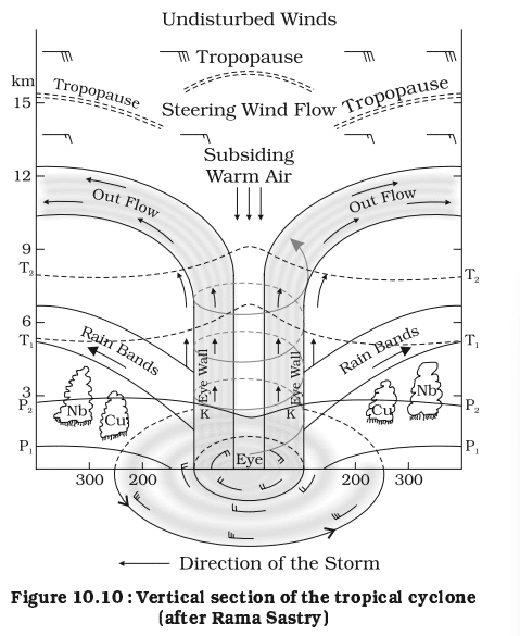
Tropical Cyclones
Tropical cyclones are intense low-pressure systems that form over warm tropical oceans and develop into powerful storms with strong winds, heavy rainfall, and storm surges. Their formation depends on warm sea temperatures, high humidity, and organized wind circulation. These systems can cause large-scale destruction when they move toward coastal regions.
Tropical Cyclones Features
- Origin: Develop over tropical and subtropical oceans between 5° and 30° latitude.
- Energy Source: Derive energy from warm ocean surfaces with temperatures above 27°C.
- Pressure Conditions: Characterized by a sharply defined low-pressure center called the eye.
- Wind Circulation:
-
- Northern Hemisphere: Anticlockwise.
- Southern Hemisphere: Clockwise.
- Cloud Structure: Surrounded by dense cumulonimbus cloud bands arranged in a spiral pattern.
- Movement: Generally move westward and curve poleward due to Coriolis force.
- Associated Hazards: High-velocity winds, torrential rainfall, and storm surges causing coastal flooding.
- Seasonality: Most active during pre-monsoon and post-monsoon periods in the Indian Ocean.
- Naming: Names assigned by WMO’s regional bodies based on predetermined lists.
- Lifecycle: Undergo stages of formation, maturation, and decay, often weakening rapidly after landfall.
Conditions Favourable for Tropical Cyclone Formation
Tropical cyclones require a combination of warm ocean temperatures, atmospheric instability, and organized wind flow to develop into powerful rotating systems. These conditions allow moisture, heat, and convection to intensify the low-pressure center.
- Warm Sea Surface Temperature: Ocean temperature above 27°C over a large area to supply heat and moisture.
- High Humidity: Sufficient moisture in the lower and middle troposphere to fuel continuous convection.
- Coriolis Force: Adequate Coriolis effect (usually beyond 5° latitude) to initiate and maintain cyclonic rotation.
- Low Vertical Wind Shear: Minimal variation in wind speed and direction with altitude to allow vertical cloud development.
- Pre-existing Low-Pressure Area: Presence of a weak low-level disturbance or cyclonic circulation to act as an initial trigger.
- Upper-Air Divergence: Strong divergence or outflow at the upper troposphere to support rising air and intensification.
- Unstable Atmosphere: Favourable lapse rate enabling warm, moist air to rise and form deep convective clouds.
Stages in the Formation of Tropical Cyclones
Cyclones evolve through a sequence of well-defined stages depending on atmospheric conditions and ocean heat availability. Each stage contributes to the organisation, intensification, or dissipation of the storm. Understanding these stages is essential for predicting cyclone behaviour.
- Formation and Initial Development Stage
-
- Begins with the transfer of heat and moisture from warm ocean surfaces through evaporation.
- Rising air cools and condenses to form cumulonimbus clouds, increasing atmospheric instability.
- A weak low-pressure area emerges, organizing into a developing cyclonic circulation.
- Mature Stage
-
- Strong convection produces vigorous thunderstorms and widespread upward motion.
- Air diverges outward at the tropopause, intensifying the low pressure at the center.
- A distinct warm “eye” develops, surrounded by dense cloud bands and extremely strong winds.
- Modification and Decay Stage
-
- Cyclone weakens when cut off from its supply of warm, moist air, typically after landfall or moving over cooler waters.
- Central pressure rises, wind speeds drop, and cloud systems begin to disintegrate.
- The storm gradually loses strength and eventually dissipates.

Tropical Cyclones Nomenclature
Tropical cyclones are given human-readable names to facilitate clear communication between meteorological agencies, governments and the public. The WMO/ESCAP Panel on Tropical Cyclones maintains pre-approved lists of names submitted by member countries; each name is used once and then retired.
- Names are chosen by regional bodies (e.g. WMO/ESCAP panel) from lists submitted by participating countries.
- Each name is short, easy to pronounce, culturally neutral, and not repeated once used.
- In the North Indian Ocean (Bay of Bengal + Arabian Sea), naming began in 2004 and is handled by the RSMC in New Delhi.
- From 2020 onwards, a new list of 169 names was adopted by the WMO/ESCAP Panel (including more countries).
- Names are used sequentially column-wise from the member-country list; once a column’s names are used, they move to the next.
| Country | Some Recent Names in List |
|
Bangladesh |
Nisarga, Biparjoy, Arnab, Upakul, Rajani, Urmi, Meghala |
|
India |
Gati, Tej, Murasu, Aag, Vyom, Jhar, Probaho, Neer, Prabhanjan, Ghurni, Ambud, Jaladhi, Vega |
|
Iran |
Nivar, Hamoon, Akvan, Sepand, Booran, Anahita, Azar, Pooyan, Arsham, Hengame, Savas, Tahamtan, Toofan |
|
Maldives |
Burevi, Midhili, Kaani, Odi, Guruva, Kurangi, Kuredhi, Horangu, Thundi, Faana |
|
Myanmar |
Kywe, Michaung, Ngamann, Kyarthit, Sapakyee, Yinkaung, Linyone, Kyeekan, Bautphat |
|
Oman |
Yaas, Remal, Sail, Naseem, Muzn, Sadeem, Dima, Manjour, Rukam, Watad, Al-jarz, Rabab, Raad |
|
Pakistan |
Gulab, Asna, Sahab, Afshan, Manahil, Zannata, Sarsar, Badban, Sarrab, Gulnar, Waseq |
|
Qatar |
Shaheen, Dana, Lulu, Mouj, Suhail, Rayhan, Anbar, Oud, Bahar, Seef, Fanar |
|
Saudi Arabia |
Jawad, Fengal, Ghazeer, Asif, Sidrah, Kaseer, Nakheel, Haboob, Bareq, Alreem, Wabil |
|
Sri Lanka |
Asani, Shakhti, Gigum, Gagana, Verambha, Ogha, Salitha, Rivi, Rudu |
|
Thailand |
Sitrang, Montha, Thianyot, Bulan, Phutala, Kraison, Matcha, Mahingsa, Phraewa, Asuri, Thara |
|
UAE |
Mandous, Senyar, Afoor, Nahhaam, Quffal, Gargoor, Khubb, Degl, Athmad, Boom, Saffar |
|
Yemen |
Mocha, Ditwah, Diksam, Sira, Bakhur, Balhaf, Brom, Shuqra, Fartak, Darsah, Samhah |
Cyclone Levels (Categories 1 to 5)
Cyclones are classified into five levels based on maximum sustained wind speed, with higher categories indicating more destructive potential.
| Levels of Cyclones and Their Wind Speed Range | |||
|
Cyclone Level |
Category |
Wind Speed Range |
Impact Severity |
|
Level 1 |
Category 1 |
119–153 km/h |
Minor damage; broken tree branches; light structural damage. |
|
Level 2 |
Category 2 |
154–177 km/h |
Moderate damage; uprooted shallow trees; damage to weak structures. |
|
Level 3 |
Category 3 |
178–208 km/h |
Major damage; roofs damaged; trees uprooted; power failures. |
|
Level 4 |
Category 4 |
209–251 km/h |
Severe damage; structural failures; widespread power outages. |
|
Level 5 |
Category 5 |
≥ 252 km/h |
Catastrophic destruction; total roof failure; large-scale devastation. |
Extratropical Cyclones (Temperate Cyclones)
Extratropical cyclones, also known as temperate cyclones or mid-latitude cyclones, form outside the tropics and are driven mainly by temperature contrasts between warm and cold air masses. These cyclones typically develop along the polar front in mid-latitudes between 30°-60°. They bring widespread rainfall, strong winds, and frontal systems affecting large areas.
- Also called mid-latitude, wave, or temperate cyclones.
- Associated with frontal systems like warm front and cold front.
- Influenced by westerlies and jet streams.
- Move from west to east and cover large spatial areas.
- Common in North America, Europe, and the North Atlantic.
Extratropical Cyclones Formation
- Develop along the polar front, where warm tropical air meets cold polar air.
Initiated by a wave-like disturbance on the front. - Cyclogenesis occurs as pressure drops and a low-pressure centre forms.
- Warm front and cold front develop and begin to rotate around the low.
- Strengthening aided by upper-air divergence and jet stream support.
Mature stage shows a comma-shaped cloud pattern with intense rainfall. - Dissipation occurs when the cyclone becomes occluded as the cold front overtakes the warm front.
Cyclones in India
Cyclones in India primarily form in the Bay of Bengal and the Arabian Sea due to warm ocean temperatures and favourable monsoon dynamics. The Bay of Bengal witnesses a higher frequency and intensity of storms, impacting eastern coastal states more severely. These cyclones significantly influence India’s climate, disaster patterns, and seasonal rainfall distribution.
- India is impacted by cyclones from two major basins, the Bay of Bengal (more active) and the Arabian Sea (increasingly intense in recent years).
- Eastern coastal states like Odisha, West Bengal, Andhra Pradesh, and Tamil Nadu face the maximum risk.
- Cyclones occur mostly in April-June and October-December, with November being the peak month.
- Bay of Bengal is more cyclone-prone due to warmer waters, low wind shear, and storm movement from the South China Sea.
- Cyclones bring heavy rainfall, flooding, storm surges, and strong winds, affecting millions along the coast.
- IMD acts as the Regional Cyclone Warning Centre, issuing alerts using satellites, radars, and models.
- India has strengthened evacuation planning, early warning systems, and cyclone shelters, reducing fatalities significantly.
- Recent years show a rise in rapid intensification and more powerful Arabian Sea cyclones due to climate warming.
Destructive Elements of Cyclones
- Strong Winds: Cyclones generate extremely powerful winds capable of uprooting trees, damaging buildings, and disrupting essential services. These winds increase rapidly near the eyewall, causing enormous destruction within a short period. Electrical and communication infrastructure is particularly vulnerable.
- Torrential Rainfall: Heavy rainfall associated with cyclones can cause widespread flooding, landslides, and soil erosion. Large amounts of precipitation accumulate over short intervals, overwhelming drainage systems. Flooding remains a major source of loss of life during cyclonic events.
- Storm Surge: Storm surges are abnormal rises in seawater levels caused by low pressure and strong onshore winds. These surges inundate coastal areas, contaminating freshwater sources and destroying agricultural land.
Cyclones Management in India
India’s strategy for managing cyclones combines structural infrastructure and advanced early-warning systems, backed by strong institutional coordination under the National Cyclone Risk Mitigation Project (NCRMP). The government has significantly strengthened last-mile alerting, evacuation networks, shelters, and community capacity, reducing cyclone-related casualties.
- The National Cyclone Risk Mitigation Project (NCRMP) strengthens coastal infrastructure, builds cyclone shelters, and improves communication networks across coastal states.
- A modern early-warning dissemination system sends alerts through SMS, sirens, radio, television, satellites, and local control rooms for timely action.
- Thousands of Multi-Purpose Cyclone Shelters (MPCS) have been constructed to house communities safely during cyclone landfalls.
- Evacuation routes, raised roads, saline embankments, and underground power cabling help minimise structural damage during storms.
- Community capacity-building programs train volunteers in first aid, search and rescue, shelter management, and disaster preparedness.
- India uses advanced forecasting tools, numerical weather models, Doppler radars, and satellite monitoring to improve cyclone prediction accuracy.
- A web-based risk atlas and decision-support system assist planners in assessing cyclone vulnerability and making informed decisions before landfall.
- Large-scale, well-organized evacuations conducted by state governments significantly reduce loss of life during severe cyclones.
- The Common Alerting Protocol helps issue location-specific warnings in multiple formats to ensure alerts reach even remote coastal villages.
- Maintenance of cyclone shelters and disaster infrastructure is now handled by state authorities to ensure long-term readiness.
- Recent government initiatives focus on climate-resilient development, improved coastal zone management, and strengthening of early-warning technology.
Western Disturbances
Western Disturbances in India are eastward-moving extratropical storms originating in the Mediterranean region that bring significant winter rainfall to northwestern India. They travel across West Asia, picking up moisture and producing cloudiness, rainfall, hailstorms, and snowfall in the Himalayas. These systems play a crucial role in supporting rabi agriculture, especially wheat, in North India.
- They are mid-latitude cyclonic systems embedded in the westerly jet stream that enter India through Pakistan and Afghanistan.
- Western Disturbances bring winter rainfall to Punjab, Haryana, Delhi, Rajasthan, and western Uttar Pradesh.
- They cause snowfall in Jammu & Kashmir, Ladakh, Himachal Pradesh, and Uttarakhand.
- Associated weather features include cloudy skies, rise in night temperatures, thunderstorms, hailstorms, and sometimes cold waves post-rainfall.
They contribute 5–10% of India’s annual rainfall, vital for the rabi crop cycle. - Interaction with tropical winds sometimes triggers intense rainfall events, leading to flooding or crop damage.
- Increased frequency and intensity in recent years is linked to climate variability and warmer oceans affecting global circulation patterns.
- Strong Western Disturbances can also influence heatwave patterns, delaying the onset of summer in north India.
![]() Last updated on March, 2026
Last updated on March, 2026
→ UPSC Final Result 2025 is now out.
→ UPSC has released UPSC Toppers List 2025 with the Civil Services final result on its official website.
→ Anuj Agnihotri secured AIR 1 in the UPSC Civil Services Examination 2025.
→ UPSC Marksheet 2025 is now out.
→ UPSC Notification 2026 & UPSC IFoS Notification 2026 is now out on the official website at upsconline.nic.in.
→ UPSC Calendar 2026 has been released.
→ Check out the latest UPSC Syllabus 2026 here.
→ UPSC Prelims 2026 will be conducted on 24th May, 2026 & UPSC Mains 2026 will be conducted on 21st August 2026.
→ The UPSC Selection Process is of 3 stages-Prelims, Mains and Interview.
→ Prepare effectively with Vajiram & Ravi’s UPSC Prelims Test Series 2026 featuring full-length mock tests, detailed solutions, and performance analysis.
→ Enroll in Vajiram & Ravi’s UPSC Mains Test Series 2026 for structured answer writing practice, expert evaluation, and exam-oriented feedback.
→ Join Vajiram & Ravi’s Best UPSC Mentorship Program for personalized guidance, strategy planning, and one-to-one support from experienced mentors.
→ Shakti Dubey secures AIR 1 in UPSC CSE Exam 2024.
→ Also check Best UPSC Coaching in India
Cyclones FAQs
Q1. What is the definition of a cyclone?+
Q2. What are cyclones also called?+
Q3. How do cyclones happen?+
Q4. Which is the longest cyclone?+
Tags: cyclones