Mountain Passes in India is a natural route through or across a mountain range, often formed by geological activity, glacial movement, or erosion from rain and snow. At lower elevations, such routes are commonly referred to as hill passes. Mountain Passes in India may range from narrow high-altitude mountains to wide valleys stretching across several miles. They are commonly located near rivers fed by precipitation and snowmelt. While a Mountain Passes in India need not be entirely flat, it is characteristically much lower in elevation compared to the surrounding peaks, providing a navigable pathway through otherwise difficult terrain.
Mountain Passes in India
Mountain Passes in India are navigable routes through mountainous terrain formed due to natural gaps or breaks. These serve as vital connectors between regions separated by mountain ranges. In India, passes such as Khardung La, Nathu La, and Rohtang Pass hold strategic, commercial, and touristic significance. Many of these are located in geopolitically sensitive areas, influencing defense strategy and international diplomacy. Mountain Passes in India are also crucial for supply chains and emergency access. Their accessibility often depends on weather, especially in snow-bound regions.
Mountain Passes in India Overview
Mountain Passes in India act as vital links between geographically isolated regions. Many are located in the Himalayas, connecting India to countries like China, Nepal, and Pakistan. These passes support military logistics, border management, and trade. Some like Rohtang and Zoji La also serve as popular tourist routes. The below table includes the Mountain Passes in India Overview:
| Mountain Passes in India Overview | |
|
Key Aspect |
Details |
|
Geopolitical Importance |
Mountain passes such as Nathu La and Khardung La connect India to neighbouring countries and act as strategic international borders. These passes are crucial for maintaining diplomatic and military relations, especially with countries like China, Nepal, and Pakistan. |
|
Tourism and Adventure |
Passes like Rohtang and Zojila attract tourists for their beauty and adventure activities like trekking, biking, and snow sports. These passes are major for tourism, especially in the Himalayan regions, promoting the local economy. |
|
Weather Conditions |
Mountain passes experience extreme weather with heavy snowfall and frequent landslides, especially during winter. Passes like Baralacha La and Zoji La often become unreachable due to harsh conditions, requiring road closures. |
|
Military Significance |
Passes such as Karakoram Pass and Bomdi-La are critical for military operations and supply chains. These high-altitude passes are vital for army movements and maintaining defence strategies along India’s borders. |
|
Cultural Exchange |
Historically, passes like Shipki La facilitated trade and cultural exchanges through routes such as the ancient Silk Route. These routes played a key role in the movement of goods, ideas, and cultures between India and its neighbours. |
|
Environmental Challenges |
High-altitude passes are prone to climate extremes, and their accessibility is often limited by changing weather patterns. Passes also face environmental concerns like glacial melts and landslides, impacting transportation and local communities. |


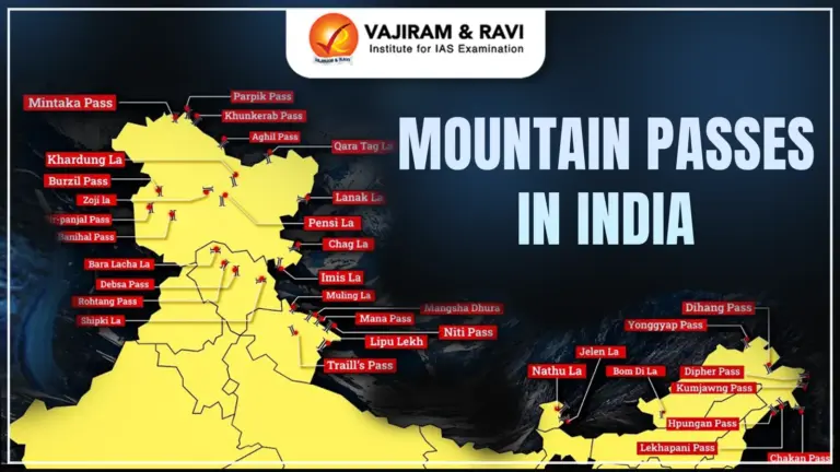
List of Mountain Passes in India
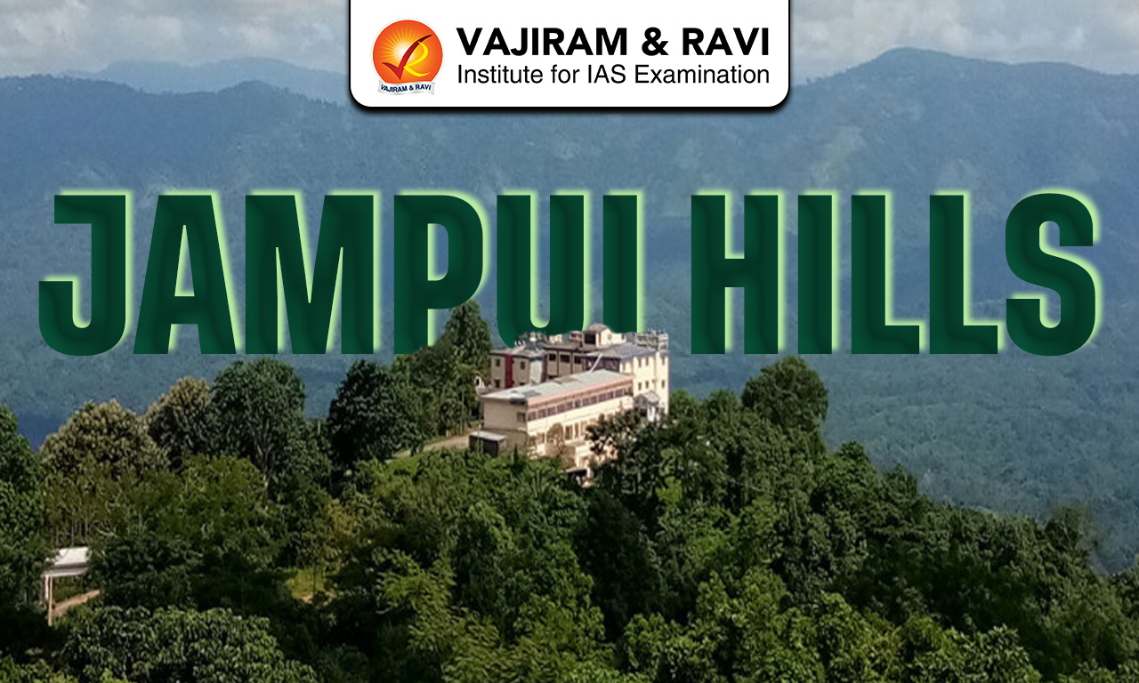
There are various Mountain Passes in India across the Himalayas, Western Ghats, and Eastern Ghats. Some of the most prominent ones include Khardung La (Ladakh), Zoji La (Jammu & Kashmir), Nathu La (Sikkim), and Rohtang Pass (Himachal Pradesh). The passes have historically enabled the movement of armies, traders, and pilgrims across the subcontinent.
| List of Mountain Passes in India | ||
|
State |
Mountain Pass |
Description |
|
Leh-Ladakh |
Chang La |
One of the highest motorable passes (17,590 ft), connecting Leh to Pangong Lake. Known for its extreme cold and low oxygen; DRDO center is nearby. |
|
Bara-Lacha La |
Connects Lahaul (Himachal) with Leh; considered the “Gateway to Ladakh.” Once a vital trade route. |
|
|
Khardung La |
Among the world’s highest motorable roads. Managed by BRO, it provides access to Nubra Valley and supports Siachen supply. |
|
|
Imis La |
Connects Ladakh with Tibet; opens into the historic and spiritually significant Hanle Valley. |
|
|
Tanglang La |
At 17,480 ft, it’s one of the highest passes, linking Debring and Gya. Offers stunning Himalayan views. |
|
|
Zoji La |
Connects Kashmir Valley with Ladakh. Faces heavy snowfall; Zoji La Tunnel construction is underway to ease access. |
|
|
Jammu & Kashmir |
Karakoram Pass |
Located in the Karakoram range, it links India and China. Once a major trade route, it’s now a high-altitude barren corridor. |
|
Pir Panjal Pass |
Connects Kashmir Valley to Rajouri. Part of the Mughal Road. Significant for India-Pakistan connectivity. |
|
|
Banihal Pass |
Located in the Pir Panjal range. Once a key route from Jammu to Srinagar; now bypassed by Jawahar Tunnel. |
|
|
Burzail Pass |
Connects Astore Valley (Kashmir) with Deosai Plains (Ladakh); strategically important and scenic. |
|
|
Pensi La |
Connects Kashmir to Kargil through the Zanskar Range; vital route for transportation and tourism. |
|
|
Himachal Pradesh |
Rohtang Pass |
Connects Kullu Valley with Lahaul-Spiti; heavily congested due to short open period (May–Oct). |
|
Shipki La |
On the India–Tibet border in Kinnaur; mostly used for Indo-Tibetan trade. Entry restricted for civilians. |
|
|
Bara-Lacha La |
Also lies partly in Himachal; important for connecting Manali to Leh via Zanskar Range. |
|
|
Debsa Pass |
Discovered in 1995 by Joydeep Sircar’s team; links Kullu to Spiti, offering trekking potential. |
|
|
Uttarakhand |
Mana Pass |
At 18,478 ft, it connects Uttarakhand to Tibet; part of Nanda Devi Biosphere Reserve. Very strategic. |
|
Niti Pass |
Historic Indo-Tibet route closed since 1962. Lies in Chamoli district. |
|
|
Lipu Lekh |
A tri-junction between India, Tibet, and Nepal. Crucial for the Kailash Mansarovar Yatra and India-China trade. |
|
|
Traill’s Pass |
Located at the Pindari Glacier’s end. Links Pindari and Milam valleys; difficult and steep trek. |
|
|
Mangsha Dhura |
Strategic Himalayan pass connecting India and Tibet; relevant during Kailash Yatra. |
|
|
Muling La |
Seasonal pass north of Gangotri at 5669m. Snow-covered in winter; links Uttarakhand and Tibet. |
|
|
North-Eastern States |
Nathu La (Sikkim) |
Connects Sikkim with Tibet. Important for Indo-China trade and military communication; requires permit for civilians. |
|
Jelep La (Sikkim) |
Historic Indo-Tibet trade route, now closed since 1962. Offers smoother terrain. |
|
|
Bom Di La (Arunachal) |
Connects Arunachal Pradesh to Tibet. Located at 8,556 ft; key military post. |
|
|
Diphu Pass (Arunachal) |
Located on tri-junction of India, China, and Myanmar. Important strategic and trade route. |
|
|
Dihang La (Arunachal) |
Connects Arunachal with Burma; lies at 4000 m. Less used, but geopolitically important. |
|
|
Pangsau Pass (Arunachal) |
Connects Arunachal with Myanmar; offers direct access to Burma from Assam plains. Also called “Hell’s Pass” during WWII. |
|
|
Western Ghats |
Bhor Ghat (Maharashtra) |
Important rail-road link between Palasdari and Khandala; vital for Mumbai-Pune route. |
|
Thal Ghat (Maharashtra) |
On the Mumbai–Nashik highway. Noted for steep gradient and scenic train route. |
|
|
Palakkad Gap (Kerala-TN) |
A low mountain pass at 460 ft that links Tamil Nadu and Kerala through the Nilgiri range. |
|
|
Shencottah Gap (TN-Kerala) |
Connects Madurai (TN) with Kottayam (Kerala). Second-largest pass in Western Ghats. |
|
Mountain Passes in India Importance
- Mountain Passes in India are the most convenient routes for crossing difficult mountainous terrain, aiding human movement and migration.
- Historically, they played a crucial role in trade, cultural exchange, and settlement between regions separated by mountains.
- Mountain Passes in India often provide the only flat or gentle terrain in mountainous regions, making them ideal for building villages or defensive outposts.
- Their strategic locations made them easier to defend, often serving as military checkpoints or fortified locations in ancient and modern conflicts.
- Mountain Passes in India act as vital links between different civilizations and cultures, promoting socio-economic interaction.
- Example: Khyber Pass has connected Central and South Asia for thousands of years, linking modern-day Kabul and Peshawar and serving as a critical trade and invasion route.
List of Mountain Passes in India State Wise
List of Mountain Passes in India – State Wise helps understand their geographical distribution. For instance, Ladakh has Khardung La and Chang La; Sikkim has Nathu La and Jelep La; Himachal Pradesh hosts Baralacha La and Rohtang Pass. In the Western Ghats, Maharashtra has Thal Ghat and Bhor Ghat, while Kerala and Tamil Nadu share the Palakkad and Shenkottai Passes. Eastern Ghats include passes like Panchpatmali (Odisha) and Ganjikunta (Andhra Pradesh).
| List of Mountain Passes in India State Wise List | ||||
|
Mountain Pass |
State/Region |
Height (m) |
Area |
Significance |
|
Aghil Pass |
Jammu and Kashmir |
4,885 |
Karakoram Range |
Links Ladakh with Xinjiang, China |
|
Auden’s Col |
Uttarakhand |
5,490 |
Garhwal Himalayas |
Popular trekking route, but difficult to access |
|
Banihal Pass |
Jammu and Kashmir |
2,832 |
Pir Panjal Range |
Links Jammu with Srinagar |
|
Bara-lacha-la |
Himachal Pradesh |
4,890 |
Zanskar Range |
Connects Lahaul district in Himachal to Ladakh |
|
Bilafond La |
Jammu and Kashmir |
5,450 |
Siachen Glacier |
Critical pass in the India-Pakistan border conflict zone |
|
Bomdila |
Arunachal Pradesh |
2,217 |
Eastern Himalayas |
Strategic military pass linking Tawang with the rest of India |
|
Changla Pass |
Ladakh |
5,360 |
Ladakh Range |
Links Leh to Pangong Lake |
|
Chankan Pass |
Jammu and Kashmir |
4,900 |
Ladakh |
Important route towards China’s border |
|
Chanshal Pass |
Himachal Pradesh |
4,520 |
Shimla |
Connects Rohru with Dodra Kwar |
|
Dehra Compass |
Uttarakhand |
N/A |
Garhwal Himalayas |
Trekking route |
|
Debsa Pass |
Himachal Pradesh |
5,360 |
Spiti Valley |
High-altitude trekking pass |
|
Dihang Pass |
Arunachal Pradesh |
4,049 |
Eastern Himalayas |
Connects India with Tibet |
|
Diphu Pass (Dipher Pass) |
Arunachal Pradesh |
4,587 |
Indo-Myanmar-China tri-junction |
Tri-junction of India, Myanmar, and China |
|
Dongkhala |
Sikkim |
4,880 |
Himalayas |
Strategic importance near Indo-China border |
|
Fotu La |
Ladakh |
4,108 |
Zanskar Range |
The highest point on the Srinagar-Leh highway |
|
Goecha La |
Sikkim |
4,940 |
Himalayas |
Gateway to Kanchenjunga Base Camp |
|
Gyong La |
Jammu and Kashmir |
5,680 |
Siachen Glacier |
Critical in the India-Pakistan border conflict |
|
Haldighati Pass |
Rajasthan |
607 |
Aravalli Range |
Historical battlefield between Maharana Pratap and the Mughals |
|
Hpungan Pass |
Arunachal Pradesh |
4,488 |
Eastern Himalayas |
Links India with Myanmar |
|
Imis La |
Jammu and Kashmir |
5,350 |
Karakoram Range |
Located near the Siachen Glacier |
|
Indrahar Pass |
Himachal Pradesh |
4,342 |
Dhauladhar Range |
Popular trekking pass between Kangra and Chamba |
|
Jalori Pass |
Himachal Pradesh |
3,120 |
Kullu Valley |
The scenic route connecting Kullu to Shimla |
|
Jelep La |
Sikkim |
4,267 |
Indo-China border |
Ancient Indo-Tibet trade route |
|
Kalindi Pass |
Uttarakhand |
5,950 |
Garhwal Himalayas |
High-altitude trekking route |
|
Karakoram Pass (Qara Tagh La) |
Jammu and Kashmir |
5,540 |
Karakoram Range |
Strategic Indo-China trade route |
|
Khardung La |
Ladakh |
5,359 |
Ladakh Range |
World’s highest motorable road |
|
Khunjerab Pass |
Jammu and Kashmir |
4,693 |
Karakoram Range |
Connects Gilgit-Baltistan with China |
|
Kongka Pass |
Jammu and Kashmir |
5,171 |
Aksai Chin |
The disputed region between India and China |
|
Kumjawng Pass |
Arunachal Pradesh |
N/A |
Eastern Himalayas |
Close to Indo-China border |
|
Kaldang Kildang La |
Himachal Pradesh |
5,300 |
Zanskar Range |
Trekking route |
|
Kunzum Pass |
Himachal Pradesh |
4,590 |
Lahaul and Spiti |
Links Lahaul to Spiti Valley |
|
Lamkhaga Pass |
Uttarakhand |
5,282 |
Garhwal Himalayas |
High-altitude trekking pass connecting Uttarakhand and Himachal |
|
Lanak Pass |
Jammu and Kashmir |
5,409 |
Aksai Chin |
The disputed area between India and China |
|
Lekhapani Pass |
Arunachal Pradesh |
N/A |
Indo-Myanmar border |
Entry point to the Stilwell Road |
|
Lipulekh Pass |
Uttarakhand |
5,334 |
Indo-China-Nepal tri-junction |
The trade route to Tibet |
|
Lungalacha La |
Himachal Pradesh |
5,059 |
Zanskar Range |
Part of the Leh-Manali highway |
|
Mana Pass |
Uttarakhand |
5,545 |
Indo-Tibet border |
Highest vehicle-accessible pass in India |
|
Mangsha Dhura |
Uttarakhand |
N/A |
Garhwal Himalayas |
Trekking route |
|
Marsimik La |
Ladakh |
5,582 |
Ladakh Range |
Higher than Khardung La, important for defence |
|
Mayodia Pass |
Arunachal Pradesh |
2,655 |
Eastern Himalayas |
Known for snowfall and strategic military importance |
|
Mintaka Pass |
Jammu and Kashmir |
4,709 |
Karakoram Range |
Old Silk Route link |
|
Muling La |
Himachal Pradesh |
5,700 |
Zanskar Range |
Trekking route |
|
Nama Pass |
Uttarakhand |
N/A |
Kumaon Range |
Historical trade route |
|
Namika La |
Ladakh |
3,700 |
Zanskar Range |
Part of the Srinagar-Leh highway |
|
Nathu La |
Sikkim |
4,310 |
Indo-China border |
Trade route between India and China |
|
Niti Pass |
Uttarakhand |
5,070 |
Indo-Tibet border |
Important for defence and trade |
|
Palakkad Gap |
Kerala-Tamil Nadu |
300 |
Western Ghats |
The widest gap in the Western Ghats connects Kerala and Tamil Nadu |
|
Pangsau Pass |
Arunachal Pradesh |
1,136 |
Indo-Myanmar border |
Part of the Stilwell Road |
|
Parpik Pass |
Jammu and Kashmir |
N/A |
Karakoram Range |
Important for trekking |
|
Pensi La |
Ladakh |
4,400 |
Zanskar Range |
Connects the Zanskar Valley with the Suru Valley |
|
Pir-Panjal Pass |
Jammu and Kashmir |
3,490 |
Pir Panjal Range |
Historic route linking Jammu with the Kashmir Valley |
|
Rezang La |
Jammu and Kashmir |
5,500 |
Ladakh Range |
Site of a famous battle in the 1962 Indo-China war |
|
Rohtang Pass |
Himachal Pradesh |
3,978 |
Pir Panjal Range |
Links Manali to Lahaul and Spiti |
|
Sasser Pass |
Jammu and Kashmir |
5,411 |
Karakoram Range |
Part of the route to the Siachen Glacier |
|
Sela Pass |
Arunachal Pradesh |
4,170 |
Eastern Himalayas |
Connects Tawang to the rest of Arunachal Pradesh |
|
Sengottai |
Tamil Nadu-Kerala |
1,300 |
Western Ghats |
Important transport route between Tamil Nadu and Kerala |
|
Shashi La |
Jammu and Kashmir |
4,900 |
Karakoram Range |
Strategic pass near Siachen |
|
Shingo La |
Himachal Pradesh |
5,091 |
Zanskar Range |
Important for trekking and border patrols |
|
Shipki La |
Himachal Pradesh |
4,722 |
Indo-Tibet border |
The trade route between India and Tibet |
|
Sia La |
Jammu and Kashmir |
5,490 |
Siachen Glacier |
Part of the Siachen conflict zone |
|
Sin La |
Uttarakhand |
5,495 |
Garhwal Himalayas |
Trekking route |
|
Spangur Gap |
Jammu and Kashmir |
5,230 |
Indo-China border |
Strategic military importance |
|
Tanglang La (Thang La) |
Ladakh |
5,328 |
Ladakh Range |
Second-highest motorable pass in India |
|
Thamarassery |
Kerala |
900 |
Western Ghats |
The scenic route connecting Kozhikode with Wayanad |
|
Traill’s Pass |
Uttarakhand |
5,200 |
Kumaon Himalayas |
High-altitude trekking pass |
|
Umling La |
Ladakh |
5,882 |
Ladakh Range |
Highest motorable road in the world |
|
Yonggyap Pass |
Himachal Pradesh |
5,090 |
Zanskar Range |
Remote trekking route |
|
Zojila Pass |
Jammu and Kashmir |
3,528 |
Zanskar Range |
Connects the Kashmir Valley to Ladakh |
![]() Last updated on March, 2026
Last updated on March, 2026
→ UPSC Final Result 2025 is now out.
→ UPSC has released UPSC Toppers List 2025 with the Civil Services final result on its official website.
→ Anuj Agnihotri secured AIR 1 in the UPSC Civil Services Examination 2025.
→ UPSC Marksheet 2025 is now out.
→ UPSC Notification 2026 & UPSC IFoS Notification 2026 is now out on the official website at upsconline.nic.in.
→ UPSC Calendar 2026 has been released.
→ Check out the latest UPSC Syllabus 2026 here.
→ UPSC Prelims 2026 will be conducted on 24th May, 2026 & UPSC Mains 2026 will be conducted on 21st August 2026.
→ The UPSC Selection Process is of 3 stages-Prelims, Mains and Interview.
→ Prepare effectively with Vajiram & Ravi’s UPSC Prelims Test Series 2026 featuring full-length mock tests, detailed solutions, and performance analysis.
→ Enroll in Vajiram & Ravi’s UPSC Mains Test Series 2026 for structured answer writing practice, expert evaluation, and exam-oriented feedback.
→ Join Vajiram & Ravi’s Best UPSC Mentorship Program for personalized guidance, strategy planning, and one-to-one support from experienced mentors.
→ Shakti Dubey secures AIR 1 in UPSC CSE Exam 2024.
→ Also check Best UPSC Coaching in India
Mountain Passes in India FAQs
Q1. How many mountain passes are there in India?+
Q2. What are the 7 mountain ranges of India?+
Q3. Which is the highest pass in India?+
Q4. What are the passes of India?+
Q5. What is a mountain pass called?+
Tags: mountain passes in india