India is home to some of the most magnificent and ancient mountain ranges in the world. These Mountain Ranges in India define the country’s geography, influence its climate, shape its river systems, and play a key role in cultural and spiritual traditions. From the towering Himalayas in the north to the scenic Nilgiris in the south, each range tells a story of geological evolution and natural beauty.
In this detailed guide, we will understand the major Mountain Ranges in India, their location, formation, highest peaks, and unique geographical features.
Mountain Ranges in India
India is a land of many beautiful mountain ranges that cover almost every part of the country. From the high Himalayas in the north to the green hills of the Western and Eastern Ghats in the south, these ranges add to India’s natural beauty. They also play an important role in climate, rivers, and rich wildlife. The details of all the important Mountain Ranges in India has been shared below.
1. The Himalayas
The Himalayas are among the most prominent and youngest fold mountain ranges in the world, formed by the collision of the Indian Plate with the Eurasian Plate millions of years ago. Stretching over 2,500 km from west to east, they form a natural barrier between the Indian subcontinent and the Tibetan Plateau.
- Length: ~2,500 km
- Width: 160-400 km
- Highest Peak: Mount Everest (8,848.86 meters)
- Spread Across: India, Nepal, Bhutan, China, and Pakistan
- Borders: Karakoram & Hindu Kush (NW), Tibetan Plateau (N), Indo-Gangetic Plain (S)
The Himalayas are divided into three main parallel ranges (from north to south):
- Greater Himalayas (Himadri)
- Lesser Himalayas (Himachal)
- Outer Himalayas (Shivalik)
I. The Greater Himalayas (Himadri)
The Greater Himalayas, also known as Himadri or the Inner Himalayas, form the northernmost and highest range of the Himalayan system. This range has an average elevation of around 6,000 meters, containing many of the world’s tallest peaks such as Mount Everest (8,849 m), Kanchenjunga (8,598 m), and Nanga Parbat. It is the permanent snow-covered zone and the origin of major glaciers like Gangotri and Satopanth, which give rise to sacred rivers such as the Ganga and Yamuna.
II. Lesser Himalayas (Himachal)
The Lesser Himalayas, also known as the Himachal Range or Middle Himalayas, lie to the south of the Himadri. They have an average elevation ranging from 3,700 to 4,500 meters and consist of rugged terrain with deep valleys and forested slopes. Major mountain ranges like the Pir Panjal, Dhauladhar, and Nag Tibba belong to this region. It is home to several popular hill stations such as Shimla, Mussoorie, Nainital, and Dharamshala, making it a prominent zone for tourism and habitation.
III. Outer Himalayas (Shivalik)
The Outer Himalayas, also known as the Shivalik Hills, form the southernmost and youngest range of the Himalayan system. They stretch for about 2,400 km from the Indus Gorge in the northwest to the Brahmaputra valley in the east, with an average height of 1,500-2,000 meters. The range is composed mainly of loose sediments and gravel, making it prone to erosion. It features fertile Doon and Duar valleys (like Dehradun), and is known by local names such as Dafla Hills, Dundwa Range, and Churia Hills in different regions.
2. The Karakoram Range
The Karakoram Range, located in the northern region of India (Ladakh and Jammu & Kashmir), is one of the most rugged and high-altitude mountain systems in the world. Stretching across India, Pakistan, and China, it features some of the highest peaks on Earth, including K2 (8,611 meters), the second-highest peak in the world. The range is also home to vast glaciers like the Siachen Glacier, which is the longest glacier outside the polar regions.
- Location: Northern India (Ladakh & J&K), extending into Pakistan and China
- Highest Peak: K2 (8,611 m), world’s second-highest mountain
- Major Glaciers: Siachen, Baltoro, Biafo, and Hispar
- Importance: Acts as a natural barrier and holds great strategic and defense significance for India
3. The Purvanchal Range
The Purvanchal Range, also known as the Eastern Hills, is an extension of the Himalayas located in northeastern India, curving southward beyond the Dihang River. It runs along the borders of Nagaland, Manipur, Mizoram, Tripura, and Assam, forming a scenic landscape of lush hills and dense forests. The region is known for its rich biodiversity, humid climate, and tribal culture, making it an ecological hotspot. These ranges also play a key role in preventing soil erosion and maintaining the stability of the northeastern terrain.
- Location: Northeastern India (Assam, Manipur, Nagaland, Mizoram, Tripura)
- Highest Peak: Dapha Bum (4,570 m)
- Major Hills: Patkai, Naga, Mizo, and Manipur Hills
- Significance: Rich in biodiversity, cultural diversity, and ecological importance
4. The Aravalli Range
The Aravalli Range, one of the oldest fold mountain ranges in the world, stretches for about 700 km from Delhi and Haryana through Rajasthan to Gujarat. Formed during the Precambrian era, it is a residual mountain range that has been heavily eroded over millions of years. Despite its age, the Aravallis play a vital role in blocking the expansion of the Thar Desert, supporting biodiversity, and maintaining ecological balance in northwestern India. The famous Mount Abu hill station and Guru Shikhar (1,722 m), its highest peak, lie within this range.
- Location: Extends across Delhi, Haryana, Rajasthan, and Gujarat
- Highest Peak: Guru Shikhar (1,722 m) in Mount Abu, Rajasthan
- Type: Ancient fold (residual) mountains
- Significance: Prevents desert spread, rich in minerals, and hosts historical sites
5. The Western Ghats
The Western Ghats, also known as the Sahyadri Hills, run parallel to the western coast of India for about 1,600 km from Gujarat to Kerala. This mountain range is one of the eight biodiversity hotspots in the world and a UNESCO World Heritage Site. It plays a major role in influencing the Indian monsoon, maintaining ecological balance, and supporting diverse flora and fauna. The region is home to scenic hill stations like Munnar, Wayanad, and Mahabaleshwar, as well as Anamudi (2,695 m), the highest peak in South India.
- Location: Extends through Gujarat, Maharashtra, Goa, Karnataka, Kerala, and Tamil Nadu
- Highest Peak: Anamudi (2,695 m), Kerala
- Local Names: Sahyadri (Maharashtra), Nilgiri, Anaimalai, and Cardamom Hills (South)
- Significance: Regulates monsoon, rich biodiversity, UNESCO World Heritage Site
6. The Eastern Ghats
The Eastern Ghats are a discontinuous and eroded mountain range running along the eastern coast of India from Odisha to Tamil Nadu. Unlike the Western Ghats, they are not continuous and are intersected by major east-flowing rivers like the Mahanadi, Godavari, Krishna, and Kaveri. These ancient hills are rich in minerals, forests, and biodiversity, playing a crucial role in the ecology and agriculture of eastern India. The Jindhagada Peak (1,690 m) in Andhra Pradesh is the highest point in the Eastern Ghats.
- Location: Extends through Odisha, Andhra Pradesh, Telangana, Karnataka, and Tamil Nadu
- Highest Peak: Jindhagada Peak or Arma Konda or Sitamma Konda(1,690 m), Andhra Pradesh
- Major Hills: Javadi, Nallamala, Palkonda, Seshachalam, and Shevaroy Hills
- Significance: Source of east-flowing rivers, rich in minerals and forest resources
7. The Vindhya Range
The Vindhya Range is a discontinuous chain of hills and plateaus located in central India, extending across Madhya Pradesh, Uttar Pradesh, and parts of Bihar and Chhattisgarh. It runs almost parallel to the Narmada River and forms a natural boundary between North and South India. The range holds great mythological and cultural significance, being mentioned in many ancient Hindu scriptures as the southern limit of the Aryavarta region. Its terrain consists of rocky ridges and forested plateaus, rich in minerals and wildlife.
- Location: Central India – Madhya Pradesh, Uttar Pradesh, Bihar, and Chhattisgarh
- Highest Peak: Sad-Bhawna Shikhar (752 m)
- Type: Discontinuous and ancient mountain range
- Significance: Marks the boundary between North and South India; rich in mineral and cultural heritage
8. The Satpura Range
The Satpura Range lies to the south of the Vindhya Range and extends through Madhya Pradesh, Maharashtra, and Chhattisgarh. It consists of a series of flat-topped plateaus and rugged hills, with an average elevation of 600-900 meters. The range is known for its dense forests, rich biodiversity, and significant role in separating the Narmada and Tapi river valleys. Its highest peak, Dhupgarh (1,350 m) near Pachmarhi in Madhya Pradesh, is also the highest point in Central India.
- Location: Extends through Madhya Pradesh, Maharashtra, and Chhattisgarh
- Highest Peak: Dhupgarh (1,350 m), near Pachmarhi
- Type: Relict (eroded) mountain range formed by plateaus
- Significance: Source of major rivers, rich in forests and wildlife sanctuaries like Pachmarhi Biosphere Reserve
9. The Nilgiri Hills
The Nilgiri Hills, meaning “Blue Mountains,” are located at the junction of Tamil Nadu, Kerala, and Karnataka, forming part of the Western Ghats. These hills are known for their rolling tea gardens, pleasant climate, and rich biodiversity. The Doddabetta Peak (2,637 m) is the highest point in the Nilgiri range and one of the highest in South India. The Nilgiris also serve as a meeting point of the Eastern and Western Ghats, making them a vital ecological and geographical link in southern India.
- Location: Junction of Tamil Nadu, Kerala, and Karnataka
- Highest Peak: Doddabetta (2,637 m), Tamil Nadu
- Known For: Tea plantations, scenic beauty, and biodiversity
- Significance: Connects Eastern and Western Ghats; major hill stations like Ooty and Coonoor
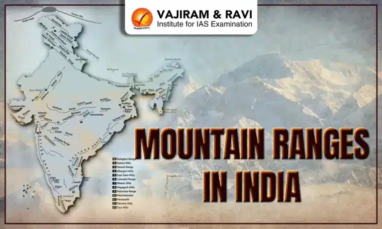
Mountain Ranges in India Map
The Mountain Ranges in India Map clearly shows how these ranges are spread across the country, shaping its geography and climate. In the north, the Himalayas and Karakoram dominate, while the Aravalli, Vindhya, and Satpura ranges define central India’s terrain. The Western and Eastern Ghats run along the peninsular coasts, and the Purvanchal hills mark the country’s eastern frontier. Together, these ranges form the backbone of India’s physical landscape.


List of Mountain Ranges in India
India has many famous mountain ranges that make the country rich in natural beauty. From the great Himalayas in the north to the green Ghats in the south, each range is special in its own way. They are home to rivers, forests, and many beautiful places to visit. All the Important mountain ranges of India have been shared below.
Mountain Ranges in North India (North to South)
The Mountain Ranges in North India are dominated by some of the world’s highest and most majestic mountain ranges, including the Himalayas and the Karakoram. Stretching from Ladakh to Arunachal Pradesh, these ranges form a natural barrier against cold winds from Central Asia and play a vital role in shaping India’s climate, rivers, and biodiversity.
| Mountain Ranges in North India (North to South) | |
|
Mountain Range |
Location/State |
|
Saltoro Mountains |
Ladakh |
|
Karakoram Range |
Ladakh |
|
Deosai Mountain |
Jammu & Kashmir |
|
Ladakh Range |
Jammu & Kashmir |
|
Zanskar Range |
Jammu & Kashmir |
|
Pir Panjal Range |
Jammu & Kashmir |
|
Zabarwan Range |
Jammu & Kashmir |
|
Dhauladhar Range |
Himachal Pradesh |
|
Kishtwar Himalaya |
Jammu & Kashmir |
|
Garhwal Himalaya |
Uttarakhand |
|
Dundwa Range |
Northern Uttar Pradesh |
Mountain Ranges in Central India (West to East)
The Mountain Ranges in Central India are mostly folded and eroded hills, rich in minerals and dense forests. Stretching from Rajasthan in the west to Jharkhand in the east, they play a key role in influencing local climate, drainage patterns, and biodiversity.
| Mountain Ranges in Central India (West to East) | |
|
Mountain Range |
Location/State |
|
Aravalli Range |
Rajasthan to Haryana |
|
Vindhya Range |
Madhya Pradesh to Uttar Pradesh |
|
Satpura Range |
Madhya Pradesh to Maharashtra |
|
Maikal Range |
Madhya Pradesh to Chhattisgarh |
|
Rajmahal Hills |
Jharkhand |
Mountain Ranges in North East India (North to South)
The Mountain Ranges in North East India are part of the Eastern Himalayas and Patkai hills, forming a natural boundary with Myanmar and China. These ranges are rich in biodiversity, covered with dense forests, and home to many tribal communities. The region includes significant ranges like Patkai, Naga, Mizo, Garo, Khasi, and Jaintia Hills, known for their scenic beauty and cultural diversity.
| Mountain Ranges in Central India (West to East) | |||
|
Mountain Range |
Location (State/Region) |
Highest Peak |
Approx. Height (m) |
|
Patkai Range |
Arunachal Pradesh, Nagaland |
Mount Saramati |
3,841 m |
|
Naga Hills |
Nagaland |
Mount Saramati |
3,841 m |
|
Khasi Hills |
Meghalaya |
Lum Shyllong |
1,965 m |
|
Jaintia Hills |
Meghalaya |
Smit Peak |
1,700 m |
|
Garo Hills |
Meghalaya |
Nokrek Peak |
1,412 m |
|
Mizo Hills (Lushai Hills) |
Mizoram |
Blue Mountain (Phawngpui) |
2,157 m |
Western Ghats Mountains (North to South)
The Western Ghats, also known as the Sahyadri Range, run parallel to India’s western coast from Gujarat to Kerala. These mountains form one of the world’s eight biodiversity hotspots, known for their lush forests, waterfalls, and diverse wildlife. Here is the list of Western Ghats Mountains (North to South).
| Western Ghats Mountains (North to South) | |
|
Mountain Range |
States |
|
Satmala Hills |
Maharashtra |
|
Ajanta Hills |
Maharashtra |
|
Harishchandra Range |
Maharashtra |
|
Balaghat Range |
Maharashtra |
|
Kudremukh |
Karnataka |
|
Baba Budan Hills |
Karnataka |
|
Nilgiri Mountains |
Tamil Nadu |
|
Akamala Machad Hills |
Kerala |
|
Anaimalai Hills |
Tamil Nadu, Kerala |
|
Palani Hills |
Tamil Nadu, Kerala |
|
Cardamom Hills |
Tamil Nadu, Kerala |
|
Varushnad Hills |
Tamil Nadu |
Eastern Ghats Mountains (North to South)
The Eastern Ghats run parallel to India’s eastern coast, extending from Odisha in the north to Tamil Nadu in the south. These discontinuous and ancient hill ranges are lower than the Western Ghats and are rich in minerals, forests, and scenic river valleys like those of the Godavari and Krishna.
| Eastern Ghats Mountains (North to South) | |
|
Mountain Range |
States |
|
Nayagarh Hills |
Odisha |
|
Bastar Plateau |
Chhattisgarh |
|
Nallamala Hills |
Andhra Pradesh, Telangana |
|
Erramala Hills |
Andhra Pradesh |
|
Velikonda Range |
Andhra Pradesh |
|
Palkonda Range |
Andhra Pradesh |
|
Seshachalam Hills |
Andhra Pradesh |
|
Nagari Hills |
Andhra Pradesh |
|
Javedi Hills |
Tamil Nadu |
|
Melagiri Range |
Tamil Nadu |
|
Shevaroy Hills |
Tamil Nadu |
|
Pachaimalai Hills |
Tamil Nadu |
|
Sirumalai Hills |
Tamil Nadu |
![]() Last updated on March, 2026
Last updated on March, 2026
→ UPSC Final Result 2025 is now out.
→ UPSC has released UPSC Toppers List 2025 with the Civil Services final result on its official website.
→ Anuj Agnihotri secured AIR 1 in the UPSC Civil Services Examination 2025.
→ UPSC Marksheet 2025 is now out.
→ UPSC Notification 2026 & UPSC IFoS Notification 2026 is now out on the official website at upsconline.nic.in.
→ UPSC Calendar 2026 has been released.
→ Check out the latest UPSC Syllabus 2026 here.
→ UPSC Prelims 2026 will be conducted on 24th May, 2026 & UPSC Mains 2026 will be conducted on 21st August 2026.
→ The UPSC Selection Process is of 3 stages-Prelims, Mains and Interview.
→ Prepare effectively with Vajiram & Ravi’s UPSC Prelims Test Series 2026 featuring full-length mock tests, detailed solutions, and performance analysis.
→ Enroll in Vajiram & Ravi’s UPSC Mains Test Series 2026 for structured answer writing practice, expert evaluation, and exam-oriented feedback.
→ Join Vajiram & Ravi’s Best UPSC Mentorship Program for personalized guidance, strategy planning, and one-to-one support from experienced mentors.
→ Shakti Dubey secures AIR 1 in UPSC CSE Exam 2024.
→ Also check Best UPSC Coaching in India
Mountain Peaks in India FAQs
Q1. Which is the oldest mountain range in India?+
Q2. Which is the highest mountain range in India?+
Q3. Which mountain range separates Northern and Southern India?+
Q4. What are the 7 major mountain ranges of India?+
Q5. Which is the 2nd highest peak in India?+
Tags: Mountain Ranges in India