Idukki Hydroelectric Project

Idukki Hydroelectric Project

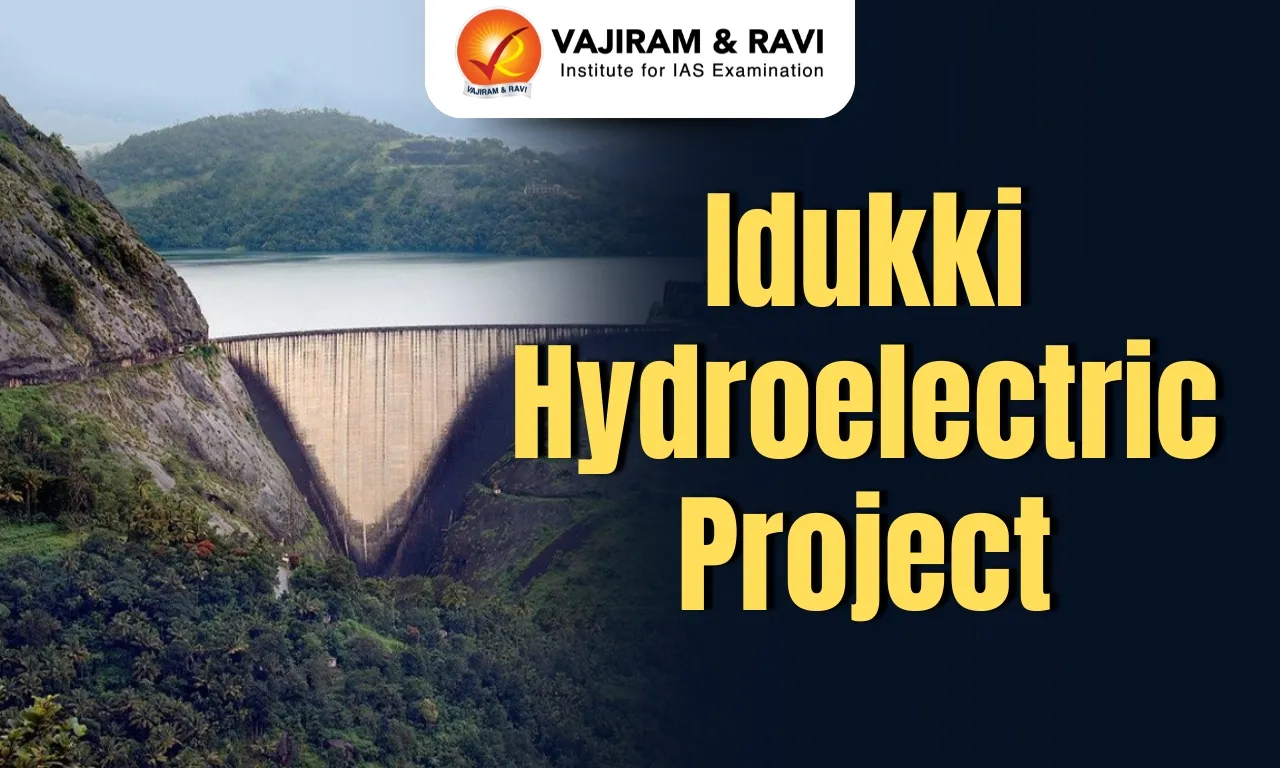
Idukki Hydroelectric Project Latest News

As the Idukki hydroelectric project, Kerala’s largest hydel power project, marks a historic 50-year milestone, the Moolamattom power plant has recorded a total generation of 115,852.672 million units (MU) over the past five decades.

About Idukki Hydroelectric Project

  • It is built across the Periyar River in the Idukki district of Kerala.
  • It is the largest hydroelectric project in Kerala.
  • The installed capacity of this project is 780 MW.
  • The powerhouse at Moolamattom is the longest underground power station in India, and the pressure shaft is the largest in the country. 
  • The powerhouse has six generators of 130 MW capacity each. 
  • The project was completed with aid from the Government of Canada, and the technical consultancy was M/s Surveyor, Nenniger and Chenevert. 
  • The project was dedicated to the nation on 12th February 1976.
  • There are three dams associated with this project. They are: Idukki Arch Dam, Cheruthoni Dam & Kulamavu Dam.
    • The Idukki dam is one of the highest ten arch dams in the world and the third highest in India after the Tehri Dam (Uttarakhand) and Bhakra Nangal Dam (Himachal Pradesh). 
    • It is the first dam in Asia that is constructed in a double-curvature arch dam type and the second in the world. 
    • The dam stands between the two mountains, Kuravanmala (839 m), and Kurathimala (925 m).

Source: TH

Idukki Hydroelectric Project FAQs

Q1: Where is the Idukki Hydroelectric Project located?

Ans: It is located in the Idukki district of Kerala.

Q2: What is the installed capacity of the Idukki Hydroelectric Project?

Ans: The installed capacity is 780 MW.

Q3: Where is the powerhouse of the Idukki project located?

Ans: The powerhouse is located at Moolamattom.

Q4: What is unique about the Moolamattom powerhouse?

Ans: It is the longest underground power station in India.

Q5: Which are the three dams associated with the Idukki project?

Ans: Idukki Arch Dam, Cheruthoni Dam, and Kulamavu Dam.

Kapilash Wildlife Sanctuary

Kapilash Wildlife Sanctuary

Kapilash Wildlife Sanctuary Latest News

The standing committee of the National Board for Wildlife (NBWL) recently gave its nod for the use of 4.68 hectares of forest land from the Kapilash wildlife sanctuary for the much-awaited 111 km six-lane capital region ring road (CRRR) project to pass.

About Kapilash Wildlife Sanctuary

  • It is located in the Dhenkanal district of Odisha.
  • It covers an area of about 125.5 sq.km. and lies in the Chota Nagpur Plateau region. 
  • It has a picturesque landscape with hills, forests, and caves and includes the Kapilasa Temple atop a hill.
    • The temple is believed to have been constructed by King Kapilendra Deb, who ruled over Odisha from 1435 to 1467 AD. 
  • Vegetation: It is classified as an Eastern Highlands moist deciduous forest ecoregion.
  • Flora: It is dominated by sal trees and a rich variety of flora like amla, teak, and kadamba.
  • Fauna
    • It is home to diverse wildlife, including elephants, jungle cats, sloth bears, spotted deer, jackals, and various species of birds such as peacocks, junglefowl, and kingfishers. 
    • It also supports several reptiles and unique species like pangolins and porcupines.

Source: MSN

Kapilash Wildlife Sanctuary FAQs

Q1: Where is Kapilash Wildlife Sanctuary located?

Ans: It is located in the Dhenkanal district of Odisha.

Q2: In which physiographic region does Kapilash Wildlife Sanctuary lie?

Ans: It lies in the Chota Nagpur Plateau region.

Q3: Which famous temple is located within Kapilash Wildlife Sanctuary?

Ans: The Kapilasa Temple is located atop a hill within the sanctuary.

Q4: Under which forest ecoregion is Kapilash Wildlife Sanctuary classified?

Ans: It is classified as an Eastern Highlands moist deciduous forest ecoregion.

Rashtriya Karmayogi Large Scale Jan Seva Programme

Rashtriya Karmayogi Large Scale Jan Seva Programme

Rashtriya Karmayogi Large Scale Jan Seva Programme Latest News

The Ministry of Personnel, Public Grievances and Pensions said that 10.5 lakh govt servants trained under Rashtriya Karmayogi Large Scale Jan Seva Programme.

About Rashtriya Karmayogi Large Scale Jan Seva Programme

  • It is a national behavioural transformation initiative for civil servants.
  • It is launched by the Capacity Building Commission (CBC). 
  • It was designed to emphasize upon the deeper sense of Seva Bhav (spirit of service) and Svadharma (duty aligned with personal purpose) among Government servants, with the objective of strengthening citizen-centric governance.
  • The initiative focused on improving quality of service delivery, enhancing responsiveness and collaboration across governance structures, and fostering greater engagement and satisfaction among officers.

What is Capacity Building Commission?

  • It is the executive body of the Mission Karmayogi framework, to drive civil service reforms through capacity building and competency-based learning.
  • It works to strengthen the human resource foundations of the government by focusing on developing individual and institutional capacities, promoting citizen-centric governance, future readiness.
  • It fosters a culture of lifelong learning across all levels of public administration.
  • The Commission designs frameworks, sets standards, and encourages collaboration to make governance more transparent, accountable, citizen-centric, and future-ready.

Source: News On Air

Rashtriya Karmayogi Large Scale Jan Seva Programme FAQs

Q1: What is the primary aim of the Rashtriya Karmayogi Jan Seva Programme?

Ans: To build a more accountable, compassionate, and citizen-centric workforce.

Q2: Who is the target audience for the Rashtriya Karmayogi Jan Seva Programme?

Ans: Government officials

Valley of the Kings

Valley of the Kings

Valley of the Kings Latest News

Two researchers recently identified close to 30 inscriptions in Tamil Brahmi, Prakrit and Sanskrit at tombs in the Valley of the Kings in Egypt.

About Valley of the Kings

  • It was the burial site of dozens of pharaohs, or kings, of ancient Egypt. 
  • The valley lies in the southern half of Egypt, just west of the Nile River. 
  • It was part of the ancient city of Thebes.
  • Most of the pharaohs of the 18th, 19th, and 20th dynasties were buried in the Valley of the Kings. 
  • These pharaohs ruled from 1539 to 1077 BC, during the period of Egyptian history known as the New Kingdom. 
  • By that time the pharaohs had stopped building pyramids to serve as their tombs. 
  • Not only pharaohs were buried in the Valley of the Kings. Several queens, a few high-ranking officials, and some royal children were also laid to rest there. 
  • The tomb built for the many sons of Ramses II is the largest and most complex in the valley.
  • The tombs in the Valley of the Kings were carved into rocky hillsides with only a doorway marking their location. 
  • The interior varied from tomb to tomb, but most consisted of a series of descending corridors with multiple openings leading to chambers, or rooms. 
  • Deep underground, one corridor ended at the burial chamber. It held a sarcophagus, or stone coffin, in which the pharaoh’s mummy was laid. 
  • The burial chamber also included furniture, clothing, jewelry, and other items that it was believed the pharaoh would need in the afterlife.
  • Virtually all the tombs in the valley were cleared out in antiquity. 
  • Some had been partially robbed during the New Kingdom, but all were systematically denuded of their contents in the 21st dynasty, in an effort to protect the royal mummies and to recycle the rich funerary goods back into the royal treasury. 
  • The only tomb to remain mostly intact was that of Tutankhamun (reigned 1333–24 BC).
  • In 1979 UNESCO made the Valley of the Kings part of the World Heritage site of ancient Thebes.

Source: TH

Valley of the Kings FAQs

Q1: What was the Valley of the Kings primarily used for?

Ans: It was the burial site of dozens of pharaohs (kings) of ancient Egypt.

Q2: Where is the Valley of the Kings located?

Ans: It lies in the southern half of Egypt, just west of the Nile River.

Q3: The Valley of the Kings was part of which ancient city?

Ans: It was part of the ancient city of Thebes.

Q4: Which dynasties’ pharaohs were mainly buried in the Valley of the Kings?

Ans: Most of the pharaohs of the 18th, 19th, and 20th dynasties were buried there.

Q5: How were the tombs in the Valley of the Kings constructed?

Ans: They were carved into rocky hillsides with only a doorway marking their location.

Mud Volcano

Mud Volcano

Mud Volcano Latest News

A mud volcano suddenly erupted in Diglipur, Andaman Islands, recently.

About Mud Volcano

  • It is a mound of mud heaved up through overlying sediments. 
  • The craters are usually shallow and may intermittently erupt mud. 
  • These eruptions continuously rebuild the cones, which are eroded relatively easily.
  • Some mud volcanoes are created by hot-spring activity where large amounts of gas and small amounts of water react chemically with the surrounding rocks and form a boiling mud. 
    • Variations are the porridge pot (a basin of boiling mud that erodes chunks of the surrounding rock) and the paint pot (a basin of boiling mud that is tinted yellow, green, or blue by minerals from the surrounding rocks).
  • Other mud volcanoes, entirely of a nonigneous origin, occur only in oil-field regions that are relatively young and have soft, unconsolidated formations. 
    • Under compactional stress, methane and related hydrocarbon gases mixed with mud force their way upward and burst through to the surface, spewing mud into a conelike shape. 
    • Because of the compactional stress and the depth from which the mixture comes, the mud is often hot and may have an accompanying steam cloud.
  • Mud volcanoes, also known as “sedimentary volcanoes” or “gas-oil volcanoes,” are close cousins to magmatic volcanoes. 
    • Like magmatic volcanoes, they can erupt powerfully and hurl flames to great heights, sometimes even several hundred meters. 
    • Instead of hot lava, it spits out mud, water, and gases from deep inside the Earth. 
  • Mud volcanoes also exist on the floor of the sea and can form islands and banks that alter the topography and shape of the coastline.
  • Approximately 1,000 mud volcanoes have been identified on land and in shallow water.
  • In India, the only mud volcano lies in Baratang Island, a part of the Andaman chain of islands.

Source: MC

Mud Volcano FAQs

Q1: What is a mud volcano?

Ans: It is a mound of mud heaved up through overlying sediments.

Q2: What is a “porridge pot” in the context of mud volcanoes?

Ans: It is a basin of boiling mud that erodes chunks of surrounding rock.

Q3: Can mud volcanoes occur under the sea?

Ans: Yes, they exist on the sea floor and can form islands and banks.

Q4: Where is the only mud volcano located in India?

Ans: It is located on Baratang Island in the Andaman chain of islands.

Continental Mantle Earthquakes

Continental Mantle Earthquakes

Continental Mantle Earthquakes Latest News

Recently the Stanford researchers have produced the first global map of a rare type of earthquake i. e Continental mantle earthquakes.

About Continental Mantle Earthquakes

  • These are seismic events which originate in the mantle beneath continents.
  • Origin: Unlike most earthquakes, which originate in the Earth’s cold, brittle crust at depths of around 10 to 29 kilometres, mantle earthquakes often occur more than 80 km below the Mohorovičić discontinuity (boundary between the crust and the mantle).
  • Impact: They are too deep to cause much shaking or danger at Earth's surface.
  • Occurrence: They occur worldwide but are regionally clustered, particularly beneath the Himalayas in southern Asia and the Bering Strait between Asia and North America. 
  • Significance: The new map will help scientists learn more about the mechanics of mantle earthquakes.

What is Mohorovičić Discontinuity?

  • It is the boundary lying between the crust and the mantle of the earth across which seismic waves change velocities.
  • It is located approximately 24 miles below the earth’s surface and 6 miles below the oceanic floor, a distance which varies from place to place.
  • The discontinuity was named after Croatian seismologist and geophysicist Andrija Mohorovicic who pioneered its discovery in 1909.

Source: DTE

Continental Mantle Earthquakes FAQs

Q1: How do scientists identify mantle quakes?

Ans: Analyzing seismic waveforms (Sn and Lg waves)

Q2: hat can trigger rupture in the continental mantle?

Ans: Tectonic stress transfer

Corruption Perceptions Index

Corruption Perception Index (CPI) 2024

Corruption Perceptions Index Latest News

India climbed five places to the 91st position out of 182 countries and territories on the Corruption Perceptions Index (CPI) 2025.

About Corruption Perceptions Index

  • It is the most widely used global corruption ranking in the world.
  • The index has been published annually by the non-governmental organisation Transparency International since 1995.
  • Methodology Used
    • It is an index which ranks countries “by their perceived levels of public sector corruption, as determined by expert assessments and opinion surveys.”
    • It uses a scale of zero to 100, where “zero” is highly corrupt and “100” is very clean.
    • It measures how corrupt each country’s public sector is perceived to be, according to experts and business people.
    • The score for each country is derived from a minimum of three data sources, selected from 13 distinct corruption surveys and assessments.
    • These sources are gathered by a range of reputed organisations, such as the World Bank and the World Economic Forum.

Key Highlights of Corruption Perceptions Index (CPI) 2025

  • Least Corrupt nations: Denmark, Finland and Singapore.
  • Most Corrupt nations: South Sudan, Somalia and Venezuela.
  • Performance of India: Its rank improved from 96 (2024) to 91 (2025).

Source: ET

Corruption Perceptions Index FAQs

Q1: What is India's rank in the Corruption Perceptions Index 2025?

Ans: 91st

Q2: Which country tops the Corruption Perceptions Index 2025?

Ans: Denmark

Lion-Tailed Macaque

Lion-Tailed Macaque

Lion‑Tailed Macaques Latest News

Researchers cautioned that the increase of lion‑tailed macaques in human-dominated landscapes is driven largely by easy access to food associated with human presence.

About Lion‑Tailed Macaques

  • It is an Old World monkey.
  • It is also known as the ‘beard ape’ because of its mane. 
  • Appearance
    • The magnificent Lion-tailed macaque is named due to its lion-like, long, thin, and tufted tail. Also they are characterised by the grey mane around their face.
    • It is one of the smallest macaque species in the world.
  • Distribution: It is endemic to evergreen rainforests of the southern part in Western Ghats, with its range passing through the three states of Karnataka, Kerala and Tamil Nadu.

Characteristics of Lion‑Tailed Macaques

  • It is an arboreal and diurnal creature, they sleep at night in trees (typically, high in the canopy of rainforest).
  • These macaques are territorial and very communicative animals. One of the distinguishing features of this species is that males define the boundaries of their home ranges by calls.
  • Overall, their communication system contains as many as 17 vocalisations.
  • Diet: It is omnivorous and feeds upon a wide variety of food, although fruits form the major part of their diet.

Conservation Status of Lion‑Tailed Macaques

  • IUCN: Endangered
  • CITES: Appendix I
  • The Wildlife (Protection) Act, 1972: Schedule I

Source: TH

Lion‑Tailed Macaques FAQs

Q1: Where are Lion-Tailed Macaques primarily found?

Ans: Western Ghats, India

Q2: What is the conservation status of Lion-Tailed Macaques?

Ans: Endangered

Lysosomal Storage Disorders

Lysosomal Storage Disorders

Lysosomal Storage Disorders Latest News

Researchers from medical and research institutions across six states and two union territories have compiled the first government-supported national biobank of a sub-section of rare diseases called Lysosomal Storage Disorders (LSDs).

About Lysosomal Storage Disorders

  • Lysosomal storage diseases or disorders (LSDs) are rare genetic conditions that cause a buildup of toxic materials in your body’s cells.
  • Examples: Gaucher, Pompe, Fabry, MPS I, MPS II, mucopolysaccharidoses, mucolipidoses, oligosaccharidoses, etc.
  • LSDs cause a buildup of toxic materials in the body’s cells.
  • The majority of the LSDs are caused by mutations in the genes encoding a lysosomal enzyme.
    • A lysosome is a membrane-bound cell organelle that contains digestive enzymes. 
    • Lysosomes are involved with various cell processes. They break down excess or worn-out cell parts.
    • People with LSDs lack certain enzymesor a substance that helps the enzyme work (enzyme activator or modifier). Enzymes assist your cells’ lysosomes with metabolism. 
    • Without functioning enzymes, your body can’t break down fats, sugars and other substances. 
    • If those build up in your body, they can be harmful. They cause dysfunction of those organs where they accumulate and contribute to great morbidity and mortality.
  • All LSDs except Hunter syndrome (MPS II) and Fabry disease are autosomal recessive disorders. This means both parents must carry the abnormal gene that prevents the body from making an enzyme with normal activity.
  • LSDs usually appear during pregnancy or soon after birth and rarely, adults may develop LSDs. 

Treatment for Lysosomal Storage Disorders

  • There are no cures for lysosomal storage diseases
  • But treatments can help you to manage your symptoms and lessen damage to organs and tissues.

Source: IE

Lysosomal Storage Disorders FAQs

Q1: What are Lysosomal Storage Disorders (LSDs)?

Ans: Genetic disorders affecting lysosomal enzyme production

Q2: Which process is disrupted in LSDs?

Ans: Lysosomal degradation of biomolecules

Science Based Targets Initiative (SBTi)

Science Based Targets Initiative

Science Based Targets Initiative (SBTi) Latest News

India has the scale and momentum to influence how global business responds to climate risk, top executives of the Science Based Targets initiative (SBTI) said recently.

About Science Based Targets Initiative (SBTi)

  • It is a corporate climate action organization that enables companies and financial institutions worldwide to play their part in combating the climate crisis.
  • Mission: To drive science-based climate action in the corporate sector consistent with limiting warming to 1.5°C.
  • SBTi develops standards, tools, and guidance which allow companies to set GHG emissions reduction targets.
  • The SBTi validates companies' targets and assists other industry leaders in creating the best practice for their organisations with targets in line with the Paris Agreement.
  • The SBTi was formed as a collaboration between the World Resources Institute, CDP, the United Nations Global Compact, and the World Wide Fund for Nature (WWF). 
  • In 2023, it was incorporated as a charity in the United Kingdom.
  • The SBTi also helps companies and financial institutions worldwide to improve their risk management, attract investors, gain a competitive advantage, and become leaders in sustainability.
  • As of April 2025, the SBTi has reported over 10,000 companies worldwide committed to or set science-based emissions reduction targets.

Source: TH

Science Based Targets Initiative (SBTi) FAQs

Q1: What is the Science Based Targets initiative (SBTi)?

Ans: It is a corporate climate action organization that enables companies and financial institutions worldwide to combat the climate crisis.

Q2: What is the mission of the Science Based Targets initiative (SBTi)?

Ans: Its mission is to drive science-based climate action in the corporate sector consistent with limiting global warming to 1.5°C.

Q3: What does the Science Based Targets initiative (SBTi) develop to help companies reduce emissions?

Ans: It develops standards, tools, and guidance to help companies set greenhouse gas (GHG) emissions reduction targets.

Q4: Which organizations collaborated to form the Science Based Targets initiative (SBTi)?

Ans: It was formed by the World Resources Institute (WRI), CDP, the United Nations Global Compact, and the World Wide Fund for Nature (WWF).

Enquire Now