Charax Spasinou

Charax Spasinou

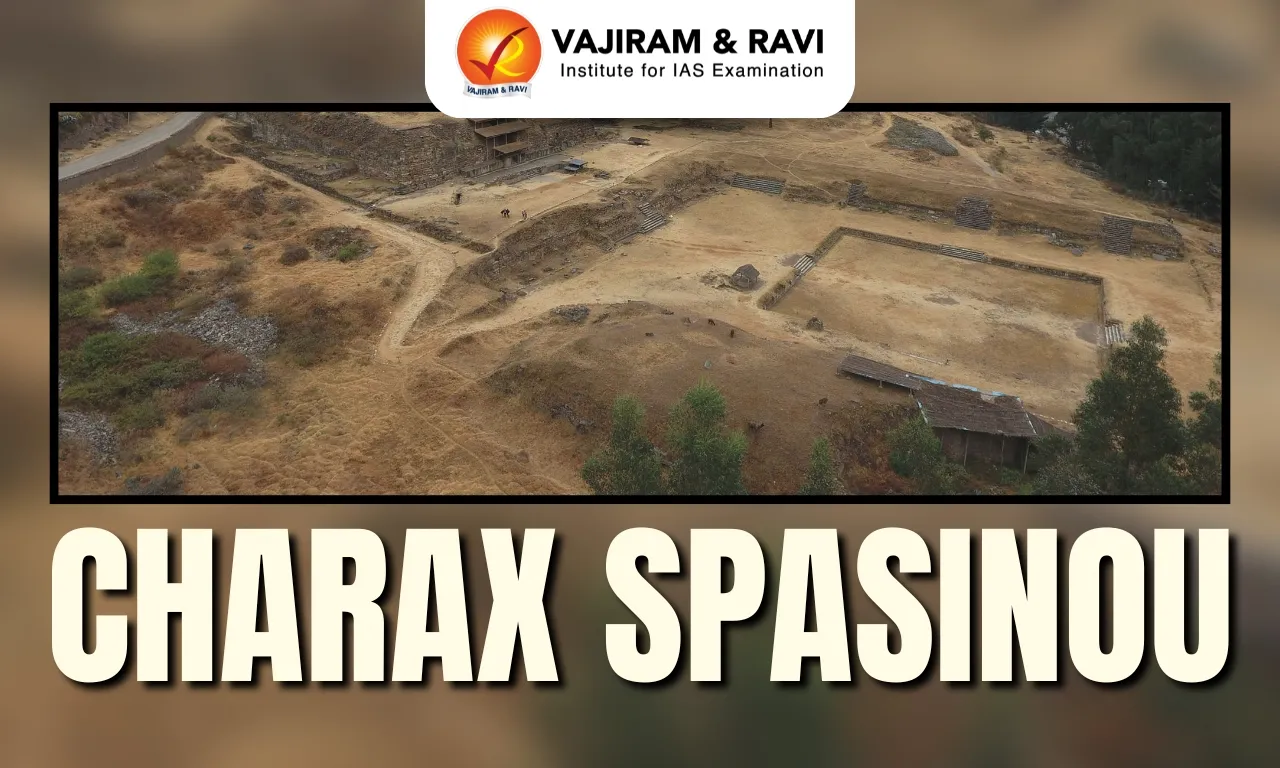
Charax Spasinou Latest News

Deep in the deserts of Iraq, the lost city of Charax Spasinou has finally been found.

About Charax Spasinou

  • It was an ancient port city located at the confluence of the Tigris and Choaspes rivers, near the modern border of Iraq and Iran.
  • Founded during the Hellenistic period, it was initially established by Alexander the Great.
  • It was reportedly founded in 324 BCE, just a few years before Alexander’s death.
  • He might have wanted it to cement control over Mesopotamia at a strategic river junction.
  • Some sources say it was originally called Alexandria.
  • The city passed to the Seleucid Empire after Alexander's death until it was destroyed at some point by flooding.
  • The city was later rebuilt by Hyspaosines, who became its first king and is recognized for founding the kingdom of Characene with Charax Spasinou as its capital.
  • Due to its favourable location, Charax became a very important harbour in the Persian Gulf area and a major trading point between Mesopotamia (a region in the Middle East) and India. 
  • The city was home to a succession of local rulers who minted coins from the late second century BC to the third century AD.
  • Charax's prominence waned around AD 224–28 with the rise of the Sassanian Empire, marking the end of Characene's political significance.

Source: TOI

Charax Spasinou FAQs

Q1: What was Charax Spasinou?

Ans: It was an ancient port city located near the confluence of the Tigris and Choaspes rivers.

Q2: During which historical period was Charax Spasinou founded?

Ans: It was founded during the Hellenistic period.

Q3: Who initially established Charax Spasinou?

Ans: It was established by Alexander the Great.

Q4: In which year was Charax Spasinou reportedly founded?

Ans: It was reportedly founded in 324 BCE.

Q5: Who rebuilt Charax Spasinou and later became its first king?

Ans: Hyspaosines rebuilt it and became its first king.

Alpheus Madhusoodanai

Alpheus Madhusoodanai

Alpheus Madhusoodanai Latest News

Researchers recently discovered a new species of pistol shrimp named Alpheus madhusoodanai in the Kochi backwaters.

About Alpheus Madhusoodanai

  • It is a new species of pistol shrimp, also known as snapping shrimp.
  • It was discovered from Kochi backwaters, Kerala.
  • It belongs to the family Alpheidae.
  • It is the first alpheid shrimp species to be recorded from an estuary in the region.
  • In local waters, they occur in small numbers and are often caught in stake nets.
  • It has a burrowing tendency and contributes to the health of mangrove ecosystems by releasing toxic gases trapped in swampy soil.

Key Facts about Pistol Shrimp

  • The pistol shrimp, also known as the snapping shrimp, possesses an extraordinary weapon — an oversized claw that can “fire” underwater bullets made of bubbles. 
  • These aren’t ordinary bubbles — they’re created through a process called sonoluminescence, “in which water is energised with specific vibrations causing emission of light through bubbles.
  • The resulting temperatures can reach an astounding 4,400°C — nearly as hot as the surface of the sun.
  • The sounds produced when the pistols of these shrimps are fired are among the loudest sounds that can be heard in the oceans.
  • The sound reaches an incredible 218 decibels — louder than a gunshot, typically around 140-175 decibels.
  • The pistol shrimp primarily uses this powerful weapon to catch prey. 
  • When hunting, it hides in its burrow, waiting for prey to come within range before firing its claw with remarkable speed and precision.
  •  There are hundreds of species found all over the world, but most species are found in reefs and seagrass beds in temperate and tropical regions.

Source: TOI

Alpheus madhusoodanai FAQs

Q1: What is Alpheus madhusoodanai?

Ans: It is a new species of pistol shrimp, also known as snapping shrimp.

Q2: Where was Alpheus madhusoodanai discovered?

Ans: It was discovered from Kochi backwaters, Kerala.

Q3: What unique weapon does the pistol shrimp possess?

Ans: It has an oversized claw that can “fire” underwater bullets made of bubbles.

Tidal Flooding

Tidal Flooding

Tidal Flooding Latest News

Recently, the Kerala government declared tidal flooding as a state specific disaster.

About Tidal Flooding

  • Tidal flooding, also known as sunny day flooding, king tide flooding, and nuisance flooding, is the temporary flooding of low-lying areas near a coast.
  • Causes: It usually occurs through the combination of winds, offshore storms, and full moon cycles during high tide events such as full moons and new moons. 
  • Unlike cyclone-induced storm surges, tidal flooding happens twice in a day and is more severe during full or new moons.
  • Impact on Kerala Coast: It is a common phenomenon along Kerala’s coastline, where the Arabian Sea level temporarily rises above an identified threshold for a brief period, inundating low-lying coastal areas.

Kerala Government's Decision

  • Kerala government declared financial assistance, similar to that provided to victims of natural disasters under State Disaster Response Fund (SDRF), to victims of floods caused by tidal rise.
  • This is the first time in the country that a State has declared tidal flooding a State-specific disaster.
  • Other State-specific disasters in Kerala: Coastal erosion, lightning, strong winds, soil piping, heatwave/sunstroke/sunburn, and human-wildlife conflict as State-specific disasters.

Source: TH

Tidal Flooding FAQs

Q1: Where is tidal flooding common in India?

Ans: Kerala's coastline

Q2: How often does tidal flooding occur?

Ans: Twice a day

Malabar Pied Hornbill

Malabar Pied Hornbill

Malabar Pied Hornbill Latest News

The Chhattisgarh Forest Department has started establishing six “hornbill restaurants” in the Udanti Sitanadi Tiger Reserve (USTR) for the rare Malabar Pied Hornbill and to promote natural forest expansion.

About Malabar Pied Hornbill

  • The Malabar pied hornbill (Anthracoceros coronatus ), also known as lesser pied hornbill, is a bird in the hornbill family.
  • Appearance: It is a medium-sized forest hornbill with striking black and white plumage and a prominent casque.
  • Habitat:  Its habitat is evergreen and moist deciduous forests, often near human settlements.
  • Distribution: It is found in the Western Ghats and north-eastern Himalayan foothill regions of India and Nepal, the Satpuda Hills, as well as in Sri Lanka. 
  • Diet: It is Frugivorous but can adapt themselves to an omnivorous diet in the breeding season.
  • Ecological Role: It is a vital indicator of the forest ecosystem’s health and stability.
  • Conservation Status: IUCN: Near Threatened
  • Threats: The primary threats to this species are habitat loss, degradation and fragmentation.

Key Facts about Udanti Sitanadi Tiger Reserve

  • Location: It is located in the state of Chhattisgarh.
  • It was established by joining the regions represented by Sitanadi and Udanti wildlife sanctuaries. 
  • The drainage system of the reserve consists of the Mahanadi as the main river, along with the Udanti, Sitanadi, Indravan, and Pairi Rivers as tributaries.
  • There are 19 named mountains in the reserve. Deo Dongri is the highest point. The most prominent mountain is Atānga Dongar.
  • Vegetation: The forest type here is predominantly tropical dry and moist deciduous.

Source: IE

Malabar Pied Hornbill FAQs

Q1: What is the diet of the Malabar Pied Hornbill?

Ans: Frugivorous (fruits)

Q2: Where is the Malabar Pied Hornbill primarily found?

Ans: Western Ghats

H-125 Helicopter

H-125 Helicopter

H-125 Helicopter Latest News

Recently, the Prime Minister of India and French President Mr Emmanuel Macron inaugurated the Final Assembly Line of the Airbus H-125 Light Utility Helicopter, located at Vemagal, Karnataka. 

About H-125 Helicopter

  • It is a single‑engine light utility helicopter from the legendary Ecureuil family.
  • It is valued for its reliability, low maintenance and adaptability.
  • The H125 is the only helicopter in history to have landed on the summit of Mount Everest.
  • Uses: It is used in emergency services, aerial filming, tourism, law enforcement, firefighting, and civil transport.

Features of H-125 Helicopter

  • High‑Altitude Performance: It can operate efficiently in “hot and high” environments — meaning high mountains or hot desert conditions.
  • Operational Versatility: It can be reconfigured for multiple roles such as rescue, medical evacuation, firefighting, passenger transport, and aerial work missions.
  • Simple and Robust Design: Its reliable engine and aerodynamics make it easier to maintain and operate in varied conditions.
  • High Cruise Speed and Range: With speeds up to around 252 km/h and a range of approximately 662 km, it’s capable of covering long distances without compromising performance.
  • Significance to India: It provides edge in high-altitude logistics, ensuring the delivery of vital supplies to remote frontline outposts, and serves as a rapid-response asset for search and rescue or medical evacuation operations.

Source: PIB

H-125 Helicopter FAQs

Q1: What is the maximum speed of the H-125 helicopter?

Ans: 252 km/h

Q2: What is the maximum altitude the H-125 helicopter can reach?

Ans: 23,000 ft

Defence Acquisition Council

Defence Acquisition Council

Defence Acquisition Council Latest News

The Defence Acquisition Council (DAC) recently cleared proposals worth nearly 3.60 lakh crore rupees to enhance the capability of the Armed Forces.

About Defence Acquisition Council

  • It is the highest decision-making body of the Defence Ministry on procurement.
  • The main objective of the DAC is to ensure expeditious procurement of the approved requirements of the armed forces in terms of capabilities sought and time frame prescribed by optimally utilizing the allocated budgetary resources.
  • Formation: It was formed after the Group of Minister’s recommendations on ‘Reforming the National Security System’, in 2001, post-Kargil War (1999).

Defence Acquisition Council Composition

  • The defence minister is the chairman of DAC. 
  • Its members include Chief of Defence Staff (CDS) and chiefs of Army, Navy and Air Force.

Defence Acquisition Council Functions

  • Give in principle approval of a 15-year Long Term Integrated Perspective Plan (LTIPP) for defence forces.
  • Accord of acceptance of necessity to acquisition proposals. 
  • Categorisation of the acquisition proposals relating to ‘Buy’, ‘Buy & Make’, and ‘Make’
  • Look into issues relating to single vendor clearance.
  • Take decisions regarding ‘offset’ provisions in respect of acquisition proposals above Rs 300 crore.
  • Take decisions regarding the Transfer of Technology under the ‘Buy & Make’ category of acquisition proposals. 
  • Field trial evaluation.

Source: NOA

Defence Acquisition Council FAQs

Q1: What is the Defence Acquisition Council?

Ans: It is the highest decision-making body of the Defence Ministry on procurement.

Q2: What is the main objective of the Defence Acquisition Council (DAC)?

Ans: To ensure expeditious procurement of approved requirements of the armed forces within the prescribed time frame by optimally utilizing budgetary resources.

Q3: When was the Defence Acquisition Council formed?

Ans: It was formed in 2001.

Q4: Who is the chairman of the Defence Acquisition Council?

Ans: The Defence Minister is the chairman.

Strait of Hormuz

Strait of Hormuz

Strait of Hormuz Latest News

Naval forces from Iran, Russia and China are set to conduct a joint military exercise in waters around the Strait of Hormuz.

About Strait of Hormuz

  • It is a narrow waterway between Iran and the Arabian Peninsula, specifically the United Arab Emirates, and Musandam (Oman).
  • The Gulf of Oman is on the strait’s east, while the Persian Gulf is on the west. 
  • It is the only sea channel linking the oil-rich Persian Gulf (west) with the Gulf of Oman and the Arabian Sea (southeast).
  • Iran is located on the north coast, while the UAE is on the south coast. 
  • At its narrowest point, the Strait of Hormuz is only 29 nautical miles wide (54 km). 
  • Islands: Some of the islands located in the Strait of Hormuz are Hengam, Hormuz, and Qishm. 
  • Significance
    • The Strait of Hormuz is considered one of the world’s most economically important choke points.
    • About 30% of the world’s liquefied gas and 25% of oil pass through the Strait of Hormuz.
    • It serves as a key passage for supertankers transporting oil and gas from Saudi Arabia, Kuwait, Iraq, Qatar, Bahrain, the UAE, and Iran.
    • Most of this energy flows to Asian markets, including China, which remains Iran’s sole significant oil customer.

Source: NIE

Strait of Hormuz FAQs

Q1: Where is the Strait of Hormuz located?

Ans: Between Iran and Oman

Q2: What is the strategic importance of the Strait of Hormuz?

Ans: Connects Indian Ocean to Persian Gulf

Shahpur Kandi Dam Project

Shahpur Kandi Dam Project

Shahpur Kandi Dam Project Latest News

India plans to block the surplus water flow from the Ravi River to Pakistan as the delayed Shahpur Kandi dam on the J&K–Punjab border heads for completion.

About Shahpur Kandi Dam Project

  • It is located on the Ravi River in Pathankot district, Punjab, downstream from the existing Ranjit Sagar Dam.
  • The water released by Ranjit Sagar Dam is utilized for generating power from this project. 
  • Declared a national project in 2008, the dam is being built at a cost of Rs 3,394.49 crore, with Punjab contributing 80 percent and the Centre funding the remaining 20 percent.
  • It is constructed by the irrigation department of the Government of Punjab.
  • It features a 55.5 m high concrete gravity dam with 206 MW power output and a 7.7 km hydel channel. 
  • The project has the potential to irrigate around 5,000 hectares in Punjab and 32,000 hectares in Jammu and Kashmir’s Sambha and Kathua districts. 
  • The dam will help save any excess Ravi water that used to flow to Pakistan during the rainy season, utilising it for the benefit of the Indian farmers.

Source: N18

Shahpur Kandi Dam Project FAQs

Q1: Where is the Shahpur Kandi Dam Project located?

Ans: It is located on the Ravi River in Pathankot district, Punjab.

Q2: Which existing dam is located upstream of the Shahpur Kandi Dam?

Ans: The Ranjit Sagar Dam.

Q3: What is the funding pattern of the Shahpur Kandi Dam Project?

Ans: Punjab contributes 80 percent and the Centre funds 20 percent.

France

France

France Latest News

Recently, India and France renewed the defence cooperation agreement for another 10 years at the 6th India-France Annual Defence Dialogue in Bengaluru.

About France

  • It is a country located in North Western Europe.
  • Bordering countries: It is bordered by 7 countries: Belgium, Luxembourg, Germany, Switzerland, Italy, Spain and Andorra.
  • Surrounding Water bodies: It is bounded by the Bay of Biscay (North Atlantic Ocean) in the west; by the English Channel in the northwest and by the Mediterranean Sea in the south. 
  • It has 5 overseas regions namely: Guadeloupe, Guyane(French Guiana), La Réunion (Réunion), Martinique and Mayotte.
  • Capital City: Paris.

Geographical Features of France

  • Climate: The climate in mainland France is temperate, with quite significant regional differences.
  • Major Rivers:  Loire (drains into Atlantic ocean ), Seine (drains into English channel).
  • Major Mountains:  Alps (southern France), Jura Mountains (north of Alps), Pyrenees (forms border with Spain).
  • Natural Resources: Coal, iron ore, bauxite, zinc, uranium, antimony, arsenic, potash, feldspar, fluorspar, gypsum.

Source: TH

France FAQs

Q1: What type of country is France?

Ans: Semi-presidential republic

Q2: What is the currency of France?

Ans: Euro

Lake Victoria

Lake Victoria

Lake Victoria Latest News

Lake Victoria’s waters have turned a haunting green, and scientists say the damage has crossed a dangerous line.

About Lake Victoria

  • It is the largest lake in Africa.
  • It lies mainly in Tanzania and Uganda but also borders Kenya.
  • It is also called Victoria Nyanza in Kenya, Nalubaale in Uganda, and Ukerewe in Tanzania. 
  • It is crossed by the equator.
  • After Lake Superior in North America, it is the second-largest freshwater lake on Earth. 
  • The lake’s area is about 69,484 sq.km. which also makes it the world’s largest tropical lake.
  • This large irregular-shaped lake has a maximum length of 359 km (north-to-south) and a maximum width of 240 km. 
  • Its waters fill a shallow depression in the centre of the great plateau that stretches between the Western and Eastern Rift Valleys.
  • The Kagera River is the major river that empties into the lake. 
  • It is the chief reservoir of the Nile River.
  • The lake supports the largest freshwater fishery in the world, producing 1 million tons of fish per year and employing 200,000 people in supporting the livelihoods of 4 million people.

Source: IDR

Lake Victoria FAQs

Q1: Which countries does Lake Victoria border?

Ans: It lies mainly in Tanzania and Uganda and also borders Kenya.

Q2: Is Lake Victoria crossed by the equator?

Ans: Yes, it is crossed by the equator.

Q3: Which is the major river that empties into Lake Victoria?

Ans: The Kagera River.

Q4: Lake Victoria is the chief reservoir of which river?

Ans: It is the chief reservoir of the Nile River.

Enquire Now