About Niti Pass:
- Location:
- It is an international high mountain pass at an elevation of 5.086m (16,686ft) located on the border of India and China.
- It connects Uttarakhand and southern Tibet.
- It was an ancient trade route between India and Tibet.
- It has remained closed since the 1962 China Sino-Indian War.
Key facts about Niti Valley:
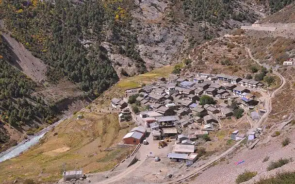
- It is a remote valley located in the northernmost region of Garhwal Himalayas in Chamoli district of Uttarakhand.
- The valley’s major river is the Dhauliganga which flows south-southwest.
- Due to high altitude at Niti Valley the winter season is hard. Due to that most residents leave the Niti Valley during winter and come back in April.
- There are 24 villages in the Niti Valley. Majority of population belongs to members of the Bhotiya scheduled tribe.
- Niti, located at an elevation of 3,600 m, is the most important village of the valley.
- Nestled within the Nanda Devi Biosphere Reserve, Niti is the last village at the Indo-China border.
Q1) What are Garhwal Himalayas?
The Garhwal Himalayas are mountain ranges located in the Indian state of Uttarakhand. This range is also a part of Himalaya Shivalik Hills, the outermost hills of the Himalaya are located in Himachal Pradesh and Uttarakhand. Major peaks of Garhwal Himalayas are Nanda Devi, Kamet, Sunanda Devi, Abi Gamin, Mana Peak and Mukut Parbat.
Source: China bid to strengthen infra, connectivity in Middle Sector


Last updated on June, 2025
→ UPSC Notification 2025 was released on 22nd January 2025.
→ UPSC Prelims Result 2025 is out now for the CSE held on 25 May 2025.
→ UPSC Prelims Question Paper 2025 and Unofficial Prelims Answer Key 2025 are available now.
→ UPSC Calendar 2026 is released on 15th May, 2025.
→ The UPSC Vacancy 2025 were released 1129, out of which 979 were for UPSC CSE and remaining 150 are for UPSC IFoS.
→ UPSC Mains 2025 will be conducted on 22nd August 2025.
→ UPSC Prelims 2026 will be conducted on 24th May, 2026 & UPSC Mains 2026 will be conducted on 21st August 2026.
→ The UPSC Selection Process is of 3 stages-Prelims, Mains and Interview.
→ UPSC Result 2024 is released with latest UPSC Marksheet 2024. Check Now!
→ UPSC Toppers List 2024 is released now. Shakti Dubey is UPSC AIR 1 2024 Topper.
→ Also check Best IAS Coaching in Delhi