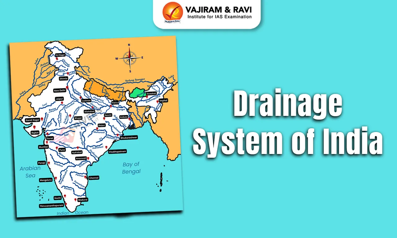
The drainage system of India comprises an extensive network of rivers, tributaries, streams, lakes and drainage basins that shapes the country’s physical and socio-economic landscape. Influenced by relief, geological structure, climate and tectonic history, the drainage system of India broadly consists of the Himalayan and Peninsular drainage systems, along with areas of inland drainage. The Himalayan rivers are generally perennial, receiving water from rainfall, snow and glacier melt, while most Peninsular rivers are predominantly rain-fed and show greater seasonal variation.
The drainage system of India supports agriculture, drinking water supply, hydropower, navigation, ecosystems and livelihoods. However, the drainage system of India faces challenges from pollution, floods, droughts, inter-state water disputes, climate change and altered river flows.
Drainage System Meaning
The drainage system of an area refers to the network of rivers, streams and other channels through which surface water is drained from a region into a common outlet or terminal basin. The drainage system is related to several factors, such as relief and slope, geological structure, rock type, climate and rainfall, tectonic history and river discharge/runoff.
- Catchment Area: A river drains the water collected from a specific area, which is called its 'catchment area'. An area drained by a river and its tributaries is called a drainage basin.
- River basin: The catchments of large rivers are called river basins, while those of small rivulets and rills are often referred to as watersheds.
- There is a slight difference between a river basin and a watershed. Watersheds are small in area, while basins cover larger areas.
- Water divide: It separates the flow of water into different drainage basins or watersheds. It is an elevated boundary or ridge that determines the direction in which water will flow.
- Water Divide in India: The major water divides of India are formed by elevated relief features such as the Himalayas, Aravalli–Delhi Ridge, Vindhya–Satpura ranges and Western Ghats, which separate different drainage basins and influence the direction of river flow.
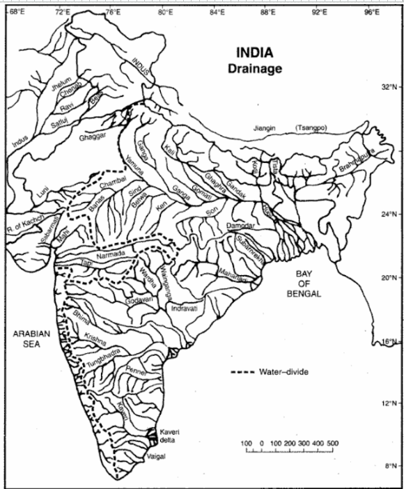
Drainage System of India and Drainage Pattern Types
India showcases a wide variety of drainage patterns, which are shaped by the physical structure of the land and the type of rock formations.
- It is characterised by large rivers and their tributaries that form a well-defined pattern across the landscape.
- The underlying geology and topography of the area primarily influence the major drainage patterns. The major drainage patterns are:
- Dendritic Drainage Pattern: A tree-like branching network formed where rivers and tributaries flow over relatively uniform rock and gently sloping terrain.

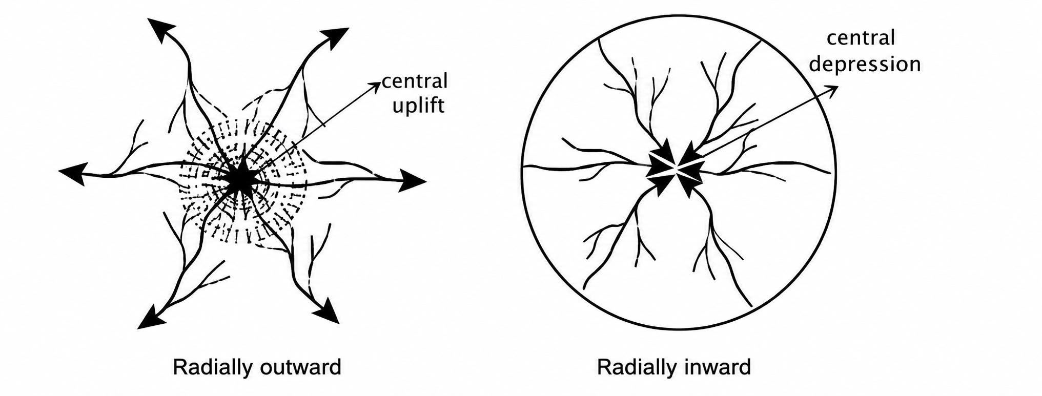
- Radial Drainage Pattern: A pattern in which streams flow outward in different directions from a central elevated area, such as the Amarkantak region.
- Centripetal Drainage Pattern: A pattern in which streams converge towards a central depression, where seasonal water accumulation may lead to evaporation and salt deposition.
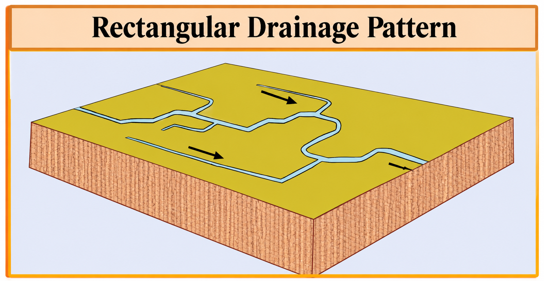
- Rectangular Drainage Pattern: A structurally controlled pattern formed in fractured or faulted rocks, with streams making sharp bends and tributaries often joining at right angles.
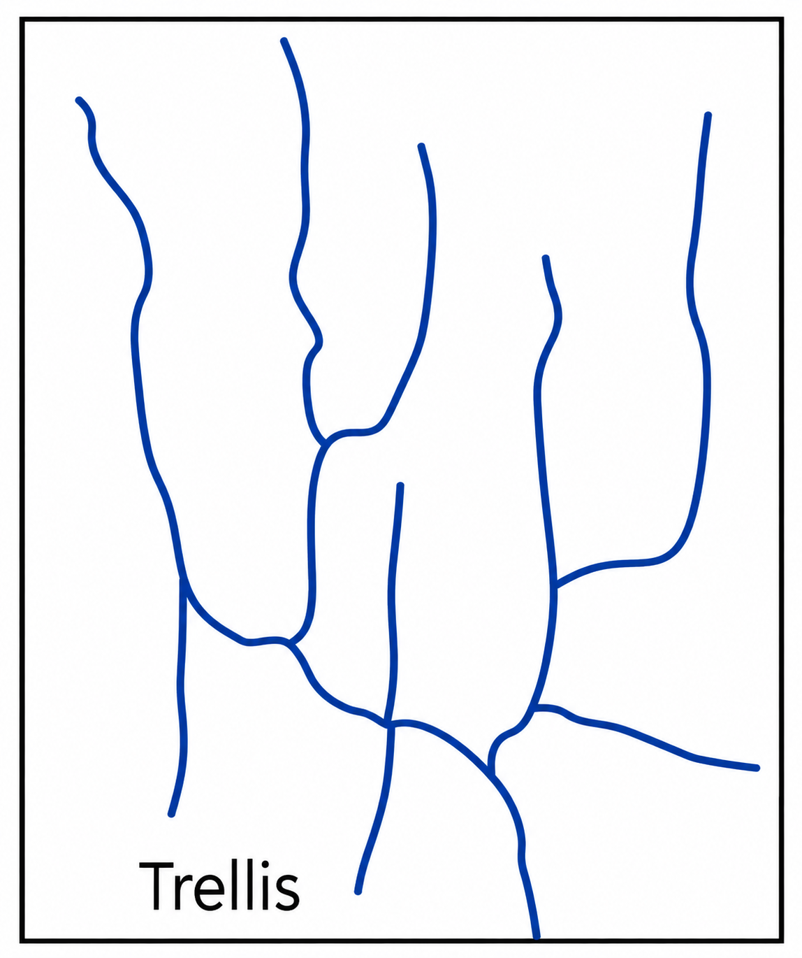
- Trellis Drainage Pattern: A pattern formed in folded terrain with alternating hard and soft rocks, where the main streams follow valleys and tributaries join them nearly at right angles.


Drainage Systems of India Classification
India's drainage system is diverse and can be classified based on factors such as water discharge, watershed size, and river characteristics. It encompasses major river basins like the Ganga and Brahmaputra, as well as the Himalayan and Peninsular drainage systems.
- Based on Direction of Drainage: India's rivers can broadly be grouped into those draining towards the Arabian Sea and those draining towards the Bay of Bengal.
- These two systems are separated by geographical features such as the Delhi Ridge, the Aravalli Range, and the Western Ghats (Sahyadris).
- There are rivers of inland drainage that terminate in lakes, depressions or disappear into the desert.
- Based on Size: Rivers are classified by watershed size into three groups: major, medium, and minor basins.
- Major basins, with catchment areas over 20,000 sq. km, include rivers like the Ganga, Brahmaputra, and Krishna.
- Medium basins, covering 2,000 to 20,000 sq. km, feature rivers like the Kalindi, Periyar, and Meghna.
- Minor basins, less than 2,000 sq. km, consist of smaller rivers in low rainfall areas.
- Based on Origin: The drainage system can also be categorised by origin and characteristics into the Himalayan Drainage System, which includes snow-fed, perennial rivers, and the Peninsular Drainage System, comprising seasonal rivers largely dependent on monsoon rainfall.
Himalayan Drainage System
The Himalayan drainage system has changed over extensive geological development. It primarily includes the Ganga, Indus, and Brahmaputra river basins. Rivers in this system are perennial because both precipitation and snowmelt nourish them.
- These rivers flow through enormous gorges formed by erosional activity occurring simultaneously with the uplift of the Himalayas.
- Along their mountainous course, these rivers create deep gorges in addition to V-shaped valleys, rapids, and waterfalls. They create depositional features like flat valleys, oxbow lakes, floodplains, braided channels, and deltas close to the river mouth as they enter the plains.
- These rivers have a very tortuous course in the Himalayan reaches, but over the plains, they exhibit a strong tendency to meander and frequently change their courses. The sediments deposited by the Himalayan river systems have contributed substantially to the formation of the vast alluvial Indo-Gangetic-Brahmaputra plains.
Peninsular Drainage System
The Peninsular drainage system is generally older and more mature than the Himalayan drainage, although its present configuration has also been modified by tectonic movements, faulting and changes in regional drainage.
- The broad, largely graded shallow valleys and the maturity of the rivers demonstrate this.
- The Western Ghats, which run close to the western coast, serve as a water divide between the major peninsular rivers, which discharge their water into the Bay of Bengal and the Arabian Sea.
Inland Drainage
Inland drainage is a hydrological system where rivers and streams do not reach an ocean or sea, instead emptying into inland lakes, landlocked seas, or disappearing into desert sands via evaporation and absorption. It is also known as an endorheic or closed basin system.
- Some rivers of western Rajasthan and adjoining arid regions do not reach the sea. They terminate in inland lakes such as Sambhar, disappear into the sands, or lose their flow through evaporation and infiltration.
- The Luni is the principal river associated with inland drainage in Rajasthan, although it ultimately reaches the Rann of Kachchh rather than the open sea.
Himalayan River System and Peninsular River System Differences
The Himalayan River System consists of perennial rivers fed by glaciers and rainfall, with long courses and high erosional activity. At the same time, the Peninsular River System has seasonal rivers, shorter courses, and relies mainly on monsoon rainfall.
| Basis of Difference | Himalayan Rivers | Peninsular Rivers |
|
Origin |
Most rivers originate from glaciers, snowfields and high-altitude springs in the Himalayas. |
Most rivers originate in the Western Ghats, Central Highlands and other parts of the Peninsular Plateau. |
|
Geological age |
Rivers are generally associated with relatively young and tectonically active mountain systems. |
Rivers flow across an ancient, stable geological landmass. |
|
Nature of flow |
Most major rivers are perennial due to rainfall, snowmelt and glacial meltwater. |
Many rivers depend mainly on monsoon rainfall, although some have more sustained flows. |
|
Drainage development |
Deep valleys, gorges and structurally controlled courses are common in mountainous areas. |
Drainage is influenced by plateau relief, rock structure, faults and fractures. |
|
Drainage patterns |
Dendritic patterns occur in the plains, while structurally controlled and irregular patterns occur in mountainous regions. |
Dendritic, radial, rectangular and trellis patterns occur in different geological settings. |
|
River length |
Major river systems generally have long courses extending from the mountains across extensive plains. |
Many rivers have comparatively shorter courses, although the Godavari, Krishna and other major rivers are long. |
|
Valley formation |
Rivers often form deep gorges and narrow valleys in mountainous regions. |
Rivers generally flow through broad valleys and plateau regions, with local gorges and waterfalls. |
|
Meandering |
Meandering is prominent in the Northern Plains, where rivers flow over relatively gentle slopes. |
Meandering occurs in some stretches, particularly in lower courses and deltaic plains. |
|
Sediment load |
Many rivers carry substantial sediment from Himalayan erosion and transport it to the plains. |
Sediment load varies with catchment geology, rainfall, erosion and land use. |
|
Direction of flow |
The Indus system drains into the Arabian Sea, while the Ganga and Brahmaputra systems drain into the Bay of Bengal. |
Most major rivers, including the Godavari, Krishna, Mahanadi and Kaveri, flow eastward; the Narmada and Tapi flow westward. |
|
Examples |
Indus, Ganga, Brahmaputra, Yamuna, Ghaghara, Gandak and Kosi. |
Godavari, Krishna, Kaveri, Mahanadi, Narmada, Tapi, Pennar and Sabarmati. |
|
Flood characteristics |
Floods may result from intense monsoon rainfall, snowmelt, glacial lake outbursts and channel changes. |
Floods are commonly associated with heavy monsoon rainfall, cyclones, reservoir releases and catchment runoff. |
Drainage System of India and Major Rivers
The drainage system of India comprises several major river systems, each playing a vital role in the country's ecology and economy. The Indus, Ganga, Brahmaputra, and Peninsular rivers significantly influence agriculture, livelihoods, and cultural practices across the nation
Indus River
- The Indus River System originates in Tibet and flows through India and Pakistan. It flows northwest between the Ladakh and Zaskar ranges, passing through Ladakh and Baltistan. It forms a gorge near Gilgit in Jammu and Kashmir.
- It enters Pakistan near Chilas in the Dardistan region. It is one of the longest rivers in the world. The major tributaries include the Jhelum, Chenab, Ravi, Beas, and Sutlej.
- The Indus plays a crucial role in supporting agriculture and livelihoods in the region.
Ganga River
- The Ganga River rises in the Gangotri glacier near Gaumukh (3,900 m) in the Uttarkashi district of Uttarakhand.
- It is known as the Bhagirathi here. The river cuts through the Central and Lesser Himalayas in narrow gorges. It passes through Uttarakhand, Uttar Pradesh, Bihar, and West Bengal. The river discharges itself into the Bay of Bengal near Sagar Island.
- The Yamuna River is a major tributary of the Ganga. Other tributaries include Son, Chambal, Gandak, Kosi, Ghaghara and others.
Brahmaputra River
- The Brahmaputra–Yarlung Tsangpo system originates in Tibet; the Angsi (Nangser) Glacier is identified in recent studies as the source of the river's longest headstream, while the Chemayungdung Glacier has traditionally been regarded as its source.
- Known as the Tsangpo in southern Tibet, it carves a deep gorge in the Central Himalayas before emerging as the Siang or Dihang.
- Entering India near Sadiya in Arunachal Pradesh, it flows into Bangladesh, where it becomes the Jamuna after the Tista joins its right bank.
- The river eventually merges with the Padma, flowing into the Bay of Bengal. Major tributaries include the Dibang, Lohit, and Subansiri.
Peninsular Rivers
The Peninsular drainage system comprises rivers flowing across the Peninsular Plateau and adjoining highlands. Most are primarily rain-fed and show greater seasonal variation, although several major rivers have substantial basins and form extensive deltas. Major rivers of the peninsular river system include:
- Narmada River: Originating from the Amarkantak Plateau, the Narmada is one of the major west-flowing rivers in India. It flows through a rift valley and empties into the Arabian Sea. The river is known for its picturesque scenery, waterfalls, and hydroelectric projects.
- Mahanadi River: The Mahanadi rises near Sihawa in the Raipur district of Chhattisgarh and runs through Odisha to discharge its water into the Bay of Bengal. The Mahanadi basin lies predominantly in Chhattisgarh and Odisha, with smaller portions extending into Maharashtra, Madhya Pradesh and Jharkhand.
- Godavari River: The Godavari is the largest peninsular river system.
- The Godavari rises at Trimbakeshwar near Nashik in Maharashtra and flows eastward into the Bay of Bengal.
- In its deltaic reaches near Rajamahendravaram (Rajahmundry), the Godavari divides into distributaries and forms an extensive delta.
- Tributaries include the Penganga, the Indravati, the Pranhita, and the Manjra.
- Krishna River: Krishna is the second largest east-flowing peninsular river, and it rises near Mahabaleshwar in the Sahyadri. Tributaries include Koyna, Tungabhadra and Bhima.
- Cauvery River: It rises in the Brahmagiri hills of Kodagu district in Karnataka. The upper catchment area receives rainfall during the southwest monsoon season, and the lower part during the northeast monsoon season.
- The Cauvery is a perennial peninsular river, with its flow sustained by monsoon rainfall from both the southwest and northeast monsoons, although discharge varies seasonally.
Drainage System of India Importance
River water in India is vital for sustaining agriculture, providing drinking water, and generating hydroelectric power. The drainage system of India, comprising its major rivers, tributaries and drainage basins, plays a crucial role in meeting these needs.
- Irrigation: The large-scale diversion of river water for irrigation supports agricultural activities, especially in the fertile plains of northern India.
- Hydroelectric Power: Many rivers, particularly in the Himalayan and hilly regions, have been dammed to harness hydroelectric power. Examples include the Bhakra Nangal Dam (Sutlej River) and the Tehri Dam (Bhagirathi River).
- Drinking Water Supply: Rivers are critical sources of potable water for both urban and rural populations.
- Programmes such as the National Mission for Clean Ganga aim to reduce pollution and restore the ecological health of the Ganga, thereby improving water quality and supporting human and ecosystem needs.
- Inland Navigation: River systems, especially in the Ganga-Brahmaputra basin, are being developed for inland waterways to facilitate cargo transportation.
- Flood Control: Some rivers, particularly in the north, are prone to flooding. Various flood management projects and embankments are constructed to mitigate flood risks.
Drainage System of India Challenges
The drainage system of India faces severe challenges from heavy pollution, erratic climate patterns, and escalating inter-state water disputes. Major challenges include
- Severe Pollution: Billions of litres of untreated sewage and industrial waste enter major rivers daily, driving bacteria levels thousands of times above safe limits and endangering aquatic life like the Ganges River dolphin.
- Climate Change and Flow Variability: Climate change is altering precipitation patterns, snow and glacier dynamics and the frequency of extreme events, increasing uncertainty in river flows and flood–drought risks.
- Inter-State and International Disputes: Competing demands for water allocation have triggered intense legal and political conflicts between states (such as Karnataka-Tamil Nadu or Odisha-Chhattisgarh) over rivers like the Kaveri and Mahanadi.
- Over-Extraction and Resource Depletion: Heavy agricultural irrigation and rapid urban consumption outpace natural monsoon replenishment, depleting base flows and lowering groundwater tables.
- Ecological Fragmentation: Dams, barrages and embankments can alter natural flow regimes, sediment transport and fish migration, affecting downstream river and delta ecosystems.
Drainage System of India Way Forward
Addressing the challenges facing the river drainage system of India requires a shift from fragmented, crisis-driven management to integrated, ecologically sound policies.
- Integrated Water Resources Management (IWRM): Adopt a holistic "basin-wide" planning approach rather than managing rivers by administrative state boundaries. Establishing empowered river basin authorities can help balance upstream and downstream needs.
- Decentralised Sewage Treatment: Shift away from massive, energy-intensive treatment plants toward decentralised, nature-based solutions (like constructed wetlands). Strictly enforce zero-liquid discharge norms for industries.
- Climate-Resilient Agriculture: Promote micro-irrigation (drip and sprinkler systems), incentivise crop diversification away from water-intensive crops like paddy and sugarcane in water-stressed regions, and scale up rainwater harvesting.
- Institutionalised Dispute Resolution: Strengthen inter-state river water disputes tribunals by enforcing time-bound decisions and establishing data-sharing platforms to build trust between states.
- Restoring Environmental Flows (E-Flows): Mandate and enforce minimum ecological flow requirements for all dammed rivers to sustain aquatic ecosystems, transport sediments, and maintain the river's self-purifying capacity.
Drainage System of India UPSC PYQs
Q1: What is water stress? How and why does it differ regionally in India? (UPSC Mains 2019)

 Last updated on Sep, 2026
→ UPSC 2027 Notification will be released on 13 January 2027 at upsconline.nic.in.
→ Asian Games 2026 are being held in Aichi-Nagoya, Japan, from 19 September to 4 October.
→ Check out the latest UPSC Syllabus here.
→ Download UPSC Model Answers for Mains 2026
→ UPSC Mains Question Paper 2026 is out now for Essay & GS Paper 1, 2, 3 & 4.
→ UPSC Calendar 2027 has been released.
→ Enroll in Vajiram & Ravi’s UPSC Mains Test Series 2027 for structured answer writing practice, expert evaluation, and exam-oriented feedback.
→ Join Vajiram & Ravi’s UPSC Mentorship Program 2027 for personalized guidance, strategy planning, and one-to-one support from experienced mentors.
→ Go through the UPSC Mains Previous Year Papers to enhance your preparation.
→ UPSC has released UPSC Toppers List 2025 with the Civil Services final result on its official website.
→ Also check Best UPSC Coaching in India
Drainage System of India FAQs
Q1. How many drainage systems are there in India?+
Q2. What is the Indian drainage system?+
Q3. What are the types of drainage systems?+
Q4. What are the four drainage patterns of India?+
Q5. Which is India's largest drainage?+
Tags: drainage system of india quest UPSC Geography Notes