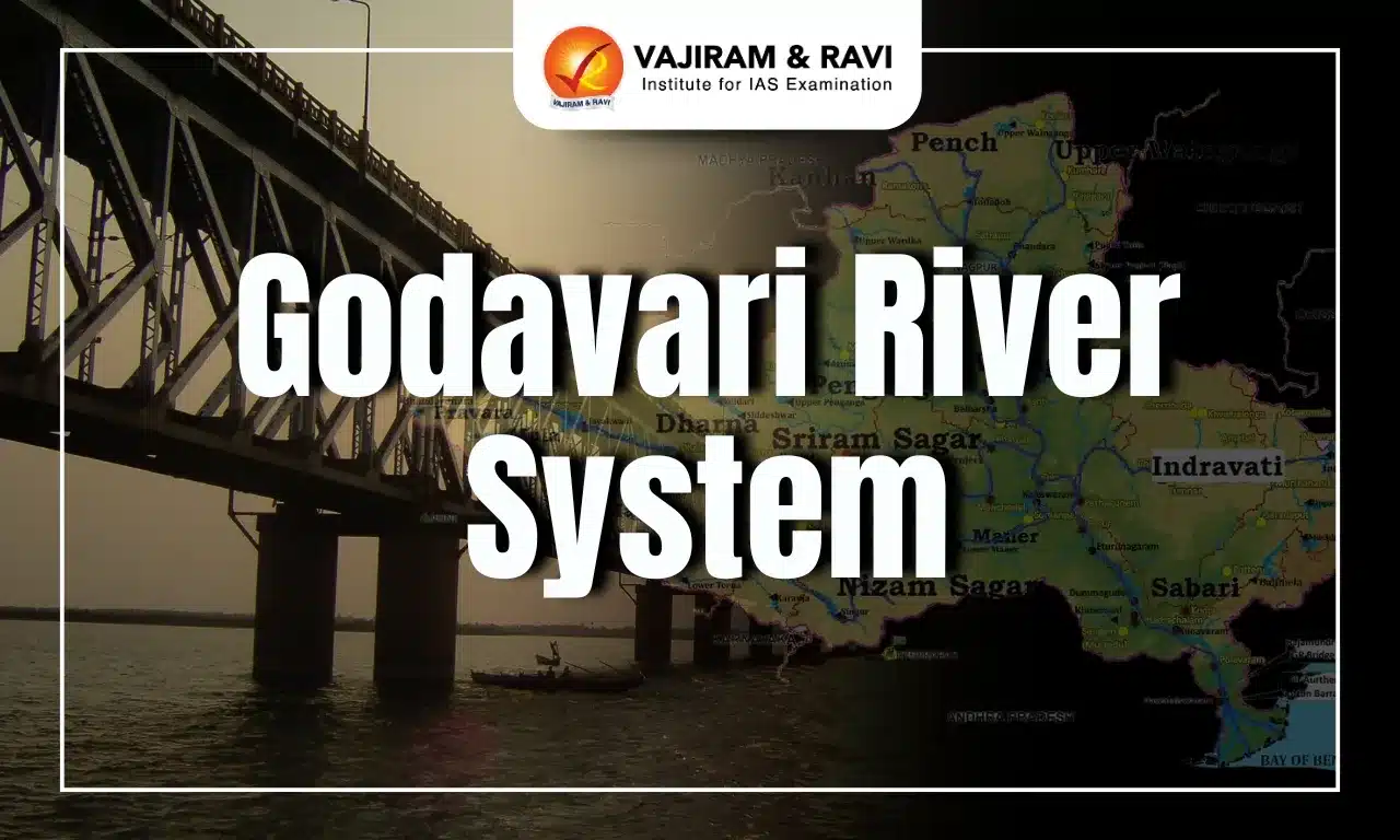
The Godavari River System, often called the Dakshina Ganga or "Southern Ganges," is the second longest river in India, stretching about 1,465 kilometers (910 miles). Originating in the Western Ghats at Trimbakeshwar in Maharashtra, it flows eastward across the Deccan Plateau and empties into the Bay of Bengal. As it traverses diverse landscapes, the Godavari forms a rich delta near Rajahmundry, where a network of distributaries boosts its fertility and agricultural potential.
Revered in Hinduism, the Godavari River is dotted with numerous pilgrimage sites where devotees perform sacred rituals. Moreover, events like the Pushkaram (Kumbh of the South) festival attract thousands, seeking spiritual purification through a sacred dip in its waters.
Godavari River System Overview
The Godavari River System, India's second longest river after the Ganga, drains the third largest basin in the country, covering approximately 10% of India's total geographical area. It flows eastward for 1,465 kilometres, passing through Maharashtra (48.7%), Andhra Pradesh (23.7%), Chhattisgarh (12.4%), and Odisha (5.7%), with smaller sections in Madhya Pradesh (7.8%), Karnataka (1.4%) and Union territory of Puducherry (0.01%).
- Origin and Draining: The Godavari River System begins in the Western Ghats near Nashik, Maharashtra, at Brahmagiri Mountain in Trimbakeshwar. It eventually flows into the Bay of Bengal via a vast system of distributaries.
- Drainage Basin: The Godavari River's extensive drainage basin spans 312,812 square kilometers, making it one of the largest in the Indian subcontinent, surpassed only by the Ganga and Indus rivers.
- Boundary: The river basin is bordered to the north by the Mahadeo Hills and Satmala Hills, to the northwest by the Ajanta Range, to the west by the North Sahyadri range of the Western Ghats, to the east and southeast by the Eastern Ghats, and to the south by the Balaghat Range.
- The interior part of the basin lies in the Maharashtra Plateau, which predominantly lies at an elevation of 300-600 meters, sloping towards the east.
- The eastern section of the basin is largely occupied by the Dandakaranya Range, with the Eastern Ghats marking the eastern boundary of the peninsula.
- Soils: The Godavari River System basin is mainly characterized by black, red, and lateritic soils, along with alluvium, mixed soils, and areas of saline and alkaline soils.
- Rainfall Pattern: The Godavari River basin experiences its highest rainfall during the Southwest monsoon, with annual rainfall ranging from 1,000 to 3,000 mm in the Western Ghats' high rainfall zone.
- The Indravati and Pranhita sub-basins receive even higher rainfall, up to 86% and 88% respectively, due to the influence of cyclonic storms.
- Issues: The Godavari River System basin experiences flooding in its lower reaches, while the coastal areas are prone to cyclones. It records India’s highest flood flows, with annual floods averaging 1.0 million cusecs.
- The flat topography of the delta regions leads to drainage congestion, and a significant portion of Maharashtra, particularly the Marathwada region, faces drought conditions.
Godavari River System Course
Godavari River System, the longest river in peninsular India with the largest catchment area and discharge, is vital for preserving the region's ecological balance. It flows eastward across the Deccan Plateau and turns southeast into Andhra Pradesh's Eluru and Alluri Sitharama Raju districts.
- Division: Below Rajahmundry, the Godavari splits into two primary streams: the Gautami Godavari to the east and the Vashishta Godavari to the west. Together, they create a vast delta before flowing into the Bay of Bengal.
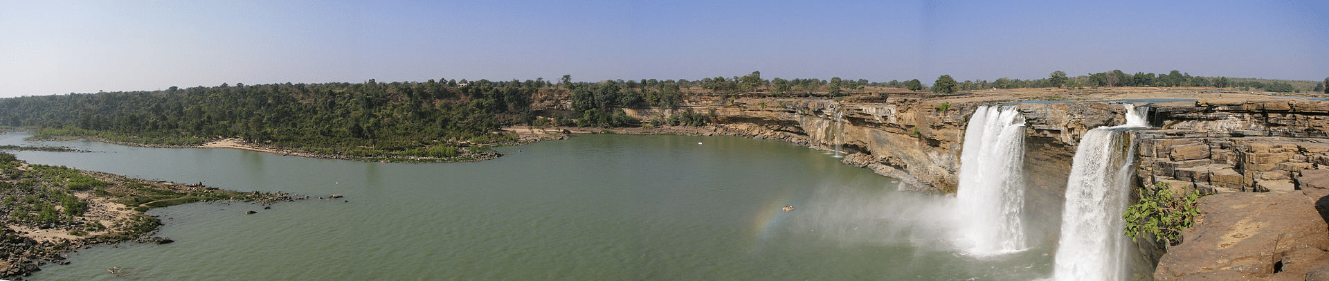
- Delta: The Godavari delta, shaped like a lobe with a rounded bulge and multiple distributaries, is a vast area of river-borne alluvium formed by deposits at the river's mouth. Silting at the mouth continues, gradually pushing the delta further into the sea.
- River Basin Sections: Moreover, the Godavari river basin is divided into three sections, collectively covering 24.16% of the total basin area.
- Upper (from the source to the Manjira confluence)
- Middle (between the Manjira and Pranhita confluences)
- Lower (from the Pranhita confluence to the mouth)


Godavari River System Tributaries
The Godavari River System has several major tributaries, with the left bank tributaries Purna, Pranahita, Indravati, Sabari, etc covering nearly 59.7% of the basin's catchment area. The right bank tributaries, including Pravara, Manjra, Maner, etc. contribute 16.14% of the basin.
- The Pranahita, the largest tributary, covers 34% of the basin and drains the Vidharba region and southern slopes of the Satpura Ranges. It conveys the combined waters of the Penganga, the Wardha, and the Wainganga, and below its confluence with the Manjira, it falls into the Godavari.
- Seven Mouths of Godavari: Before entering the Bay of Bengal, the Godavari forms seven mouths. Collectively, these branches are called Sapta Godavari, while the river before splitting is known as Akhanda Godavari. These branches are
- Tulyabhaga (Kasyapa)
- Atreya (Atri)
- Gautami (Gautama)
- Jamadagni (replaced by Vṛddhagautami)
- Bhardvaja (Bharadvaja)
- Kausika (Visvamitra)
- Vasișțha (Vasishtha)
Right Bank Tributaries
The right bank tributaries of the Godavari play a significant role in draining the river’s basin. These tributaries, including the Pravara, Manjra, Manair, etc contribute to the flow and overall catchment area of the Godavari.
- Manjra River: The Manjra River, flows through Maharashtra, Karnataka, and Telangana and holds the Nizam Sagar reservoir. In recent years, the upper reaches of the Manjra in Maharashtra have faced environmental degradation, resulting in increased runoff and erosion.
- Source and Joining: It has its source in the Balaghat range, near Ahmednagar district in Maharashtra, and merges with the Godavari at the border between Maharashtra and Telangana.
- Pravara River: The Pravara, the smallest of the major Godavari tributaries, is located in Maharashtra. It originates on the eastern slopes of the Western Ghats and both its source and confluence are in the Ahmednagar district.
Left Bank Tributaries
The left-bank tributaries of Godavari river are more numerous and larger than the right-bank tributaries. These include the Dharna, Penganga, Wainganga, Wardha, Pranahita (which carries the combined waters of Penganga, Wardha, and Wainganga), Pench, Kanhan, Sabari, Indravati, etc.
- Penganga: The Penganga (Painganga) River originates in the Ajanta ranges in the Aurangabad district, Maharashtra. It flows through Buldhana and Washim districts. It then continues along the border between Maharashtra and Andhra Pradesh.
- Confluence: It joins the Wardha River near the village of Wadha in Yavatmal district. The Wardha River merges with the Pranahita River, which then flows into the Godavari River.
- Nature: The river is deeply entrenched, making navigation difficult.
- Irrigation: The Penganga provides vital irrigation to Washim and Yavatmal districts.
- Waterfall and Wildlife Sanctuary: The river passes through the Painganga Wildlife Sanctuary and features the Sahastrakund waterfalls.
- Wainganga: The Wainganga River, originating in the Mahadeo Hills near Gopalganj in Madhya Pradesh, flows through urban areas such as Kamptee, Bhandara, Tumsar, Balaghat, and Pauna.
- Course: Flowing southward for approximately 580 kilometers, it traverses Madhya Pradesh and Maharashtra.
- Confluence: Upon merging with the Wardha River, the combined stream, now known as the Pranahita River, eventually joins the Godavari at Kaleshwaram in Telangana.
- Wardha: The Wardha River is a significant river in Vidarbha, Maharashtra, originating from the Satpura Range. It flows for 32 km in Madhya Pradesh before entering Maharashtra, covering another 528 km before merging with the Wainganga River to form the Pranahita, which eventually drains into the Godavari.
- Dams: The Upper Wardha Dam near Morshi serves as a vital water source for Amravati, Morshi, and Warud Talukas. Additionally, the Lower Wardha Dam is situated near Warud Bagaji and Dhanodi in Amravati District.
- Indravati: The Indravati River originates from Thuamul Rampur in Kalahandi, Odisha. It is often referred to as the "lifeline" of Odisha's Kalahandi and Nabarangapur districts, as well as Chhattisgarh's Bastar district, known for its rich greenery.
- Confluence: After flowing 233 kilometers in Chhattisgarh, the Indravati River turns south, marking the boundary between Chhattisgarh and Maharashtra before joining the Godavari River at the tri-state junction of Maharashtra, Chhattisgarh, and Telangana.
- Dam: The Indravati Dam, also known as the Upper Indravati Hydro Power Project, near Mukhiguda in Kalahandi, is one of Asia's largest dams, generating 600 MW of electricity.
- Waterfall: Chitrakoot Falls lies about 40 kilometers from Jagdalpur in Chhattisgarh.
- National Park and Reserves: Indravati National Park and Tiger Reserves are situated in the neighboring region of Chhattisgarh state.
Godavari River System Projects
Godavari River System projects in Maharashtra include the 600 MW Upper Indravati, the largest hydropower station on the river, which diverts water to the Mahanadi River basin for power generation and irrigation. Despite this, the river has one of the lowest utilizations of its water energy for hydroelectric power generation.
- Projects Completed: Notable projects on the Godavari and its tributaries include
- Godavari Canal Irrigation Project
- Upper Penganga
- Jayakwadi
- Upper Wainganga
- Upper Indravati
- Upper Wardha
- Ongoing Projects: The major ongoing projects include the Pranahita-Chevalla and Polavaram (Andhra Pradesh).
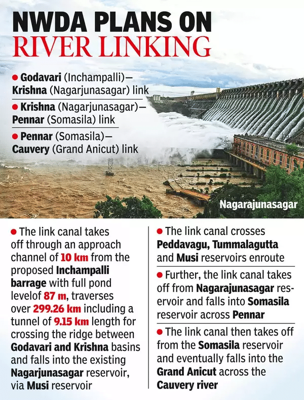
- Godavari and Cauvery Interlinking Project: The project involves transferring 247 thousand million cubic feet (tmcft) of unutilized water from the Indravati sub-basin of the Godavari River to the Cauvery River basin.
- Components: The project comprises three components: Godavari (Inchampalli/Janampet) to Krishna (Nagarjuna Sagar), Krishna (Nagarjuna Sagar) to Pennar (Somasila), Pennar (Somasila) to Cauvery.
- Method: Water will be lifted to the Nagarjuna Sagar Dam and then channeled southward to meet the demands of the Krishna, Pennar, and Cauvery basins.
- Irrigation Impact: The project aims to provide irrigation facilities to approximately 345,000 to 504,000 hectares in the Prakasam, Nellore, Krishna, Guntur, and Chittoor districts of Andhra Pradesh.
Dams
The main Godavari River is dammed extensively up to its confluence with the Pranhita tributary to maximize irrigation, though its major tributaries—Pranahita, Indravati, and Sabari—carry three times more water than the main river. Some of the dams situated in the river basin include:
- Gangapur Dam: Located 10 km upstream of Nashik, the Gangapur Bandh Sagar Dam provides drinking water to the city and supplies water to the Eklahare thermal power station.
- Vishnupuri Barrage: Located 5 km from Nanded, it is Asia's largest lift irrigation project.
- Jayakwadi Dam: One of India's largest earthen dams near Paithan, was constructed to manage flooding during monsoons and combat droughts in the Marathwada region.
- Sriram Sagar Dam: Located on the Godavari River between Adilabad and Nizamabad districts, it is a vital multipurpose project that supports irrigation in several Telangana districts and generates power.
Urban Centers and Industries
The Godavari River basin includes key urban centers like Nagpur, Aurangabad, Nashik, and Rajahmundry. Nashik and Aurangabad have a strong industrial presence, especially in the automotive sector.
- Agriculture-based industries such as rice milling, cotton spinning, sugar production, and oil extraction dominate the region.
- Additionally, the basin supports a cement industry and several small engineering enterprises.
Godavari River System Mineral Deposits
The Godavari River System basin is abundant in various mineral resources, including oil and gas, coal, iron, limestone, manganese, copper, bauxite, granite, and laterite.
- Upper Basin: The upper portion of the basin, composed of the Deccan Traps, is rich in minerals like hypersthene, augite, diopside, enstatite, magnetite, zircon, apatite, chlorite, etc.
- Central Basin: The central portion of the basin mainly consists of Archean granites and Dharwar formations, including phyllites, quartzites, amphiboles, and granites.
- The downstream middle basin is primarily composed of Cuddapah and Vindhyan metasediments, with quartzites, sandstones, shales, limestones, and conglomerates, while the Gondwana group includes detritals and thick coal seams.
- Lower Basin: The lower basin is dominated by the Eastern Ghats, formed mainly from Khondalites, with tertiary Rajahmundry sandstones exposed in the coastal region.
Godavari River System Flora and Fauna
The Godavari River System basin is home to diverse flora and fauna, with the Krishna-Godavari Basin serving as a key nesting site for the vulnerable olive ridley sea turtle and the fringed-lipped carp.
- Coringa Mangrove Forests and Wildlife Sanctuary: The Coringa mangrove forests, the third largest in India, are vital for supporting various fish and crustaceans and act as a protective barrier against cyclones. The Coringa Wildlife Sanctuary, known for its reptiles, is part of these forests.
- Jayakwadi Bird Sanctuary: Located near Paithan, it provides a habitat for numerous bird species and has islands within the Nath Sagar Reservoir as nesting sites.
- Nandur Madhmeshwar Bird Sanctuary: It is also called the "Bharatpur of Maharashtra" and is famous for its rich birdlife, located near Nashik.
Godavari River System Significance
The Godavari River System holds immense significance in India, impacting various aspects of life and the environment across its extensive basin.
- Agricultural Support: The Godavari River's extensive network of tributaries and reservoirs supports the cultivation of various crops, including rice, cotton, sugarcane, and pulses, thereby contributing significantly to the agricultural output of Maharashtra, Telangana, Andhra Pradesh, and Chhattisgarh.
- Furthermore, the fertile delta areas, particularly in Andhra Pradesh, are renowned for rice cultivation.
- Major dams such as the Sriram Sagar Dam in Telangana and the Jayakwadi Dam in Maharashtra facilitate irrigation, enhancing agricultural productivity in these regions.
- Water Supply: Millions of people across multiple states rely on the Godavari for their daily water needs, including drinking and industrial use. This vital resource supports urban areas and rural communities alike.
- Hydroelectric Power Generation: The river and its tributaries are harnessed for hydroelectric power, contributing to the energy supply in the region. Major projects like the Sriram Sagar and Polavaram dams utilize its flow to generate electricity.
- Ecological Importance: The Godavari River System supports diverse ecosystems, including unique habitats in its delta region, which are essential for wildlife and biodiversity. The river's health is crucial for maintaining these ecological balances.
- Cultural and Religious Significance: The Godavari, a sacred river in Hinduism, is central to religious events like the Kumbh Mela of the South, known as Pushkaram, which occurs every twelve years. Pilgrims visit its banks for rituals and festivals, highlighting its spiritual significance.
Godavari River System UPSC PYQs
Question1. Consider the following rivers: (UPSC Prelims 2015)
- Vamsadhara
- lndravati
- Pranahita
- Pennar
Which of the above are tributaries of Godavari?
(a) 1, 2 and 3
(b) 2, 3 and 4
(c) 1, 2 and 4
(d) 2 and 3 only
Answer: (d)
Question2: Which river is referred to as the 'Dakshina Ganga' due to its importance in peninsular India? (UPSC Prelims 2018)
- a) Krishna
b) Kaveri
c) Godavari
d) Mahanadi
Answer: (c)
Question3. "Evaluate the impact of river systems on regional agriculture and economy, with special reference to the Godavari River." (UPSC Mains 2020)
![]() Last updated on March, 2026
Last updated on March, 2026
→ UPSC Final Result 2025 is now out.
→ UPSC has released UPSC Toppers List 2025 with the Civil Services final result on its official website.
→ Anuj Agnihotri secured AIR 1 in the UPSC Civil Services Examination 2025.
→ UPSC Marksheet 2025 is now out.
→ UPSC Notification 2026 & UPSC IFoS Notification 2026 is now out on the official website at upsconline.nic.in.
→ UPSC Calendar 2026 has been released.
→ Check out the latest UPSC Syllabus 2026 here.
→ UPSC Prelims 2026 will be conducted on 24th May, 2026 & UPSC Mains 2026 will be conducted on 21st August 2026.
→ The UPSC Selection Process is of 3 stages-Prelims, Mains and Interview.
→ Prepare effectively with Vajiram & Ravi’s UPSC Prelims Test Series 2026 featuring full-length mock tests, detailed solutions, and performance analysis.
→ Enroll in Vajiram & Ravi’s UPSC Mains Test Series 2026 for structured answer writing practice, expert evaluation, and exam-oriented feedback.
→ Join Vajiram & Ravi’s Best UPSC Mentorship Program for personalized guidance, strategy planning, and one-to-one support from experienced mentors.
→ Shakti Dubey secures AIR 1 in UPSC CSE Exam 2024.
→ Also check Best UPSC Coaching in India
Godavari River System FAQs
Q1. Where does the Godavari River originate?+
Q2. What is the length of the Godavari River?+
Q3. Which river is known as the "Dakshina Ganga"?+
Q4. Which tributary is the largest of the Godavari?+
Q5. Where does the Godavari River empty into?+
Tags: quest UPSC Geography Notes