The Indus River System is one of the three major Himalayan river basins and world’s largest and most ancient river basins. With its vast network of tributaries, it sustains diverse ecosystems and human settlements, contributing significantly to agriculture, culture, and the economy of both the countries it is flowing into that is India and Pakistan. This article provides an in-depth study of the Indus River System, covering its origin, course, major tributaries, and significance.
Indus River System
The Indus River System is among the largest and oldest river basins in the world. Originating in the Himalayas, it covers India and Pakistan, nourishing fertile lands and supporting diverse ecosystems. The system includes six major rivers, Indus, Jhelum, Chenab, Ravi, Beas, and Satluj which have played a crucial role in shaping South Asian history and culture. The Indus Waters Treaty (1960) governs water distribution between India and Pakistan. Under this agreement, Pakistan controls the Indus, Jhelum, and Chenab, while India manages Ravi, Beas, and Satluj.
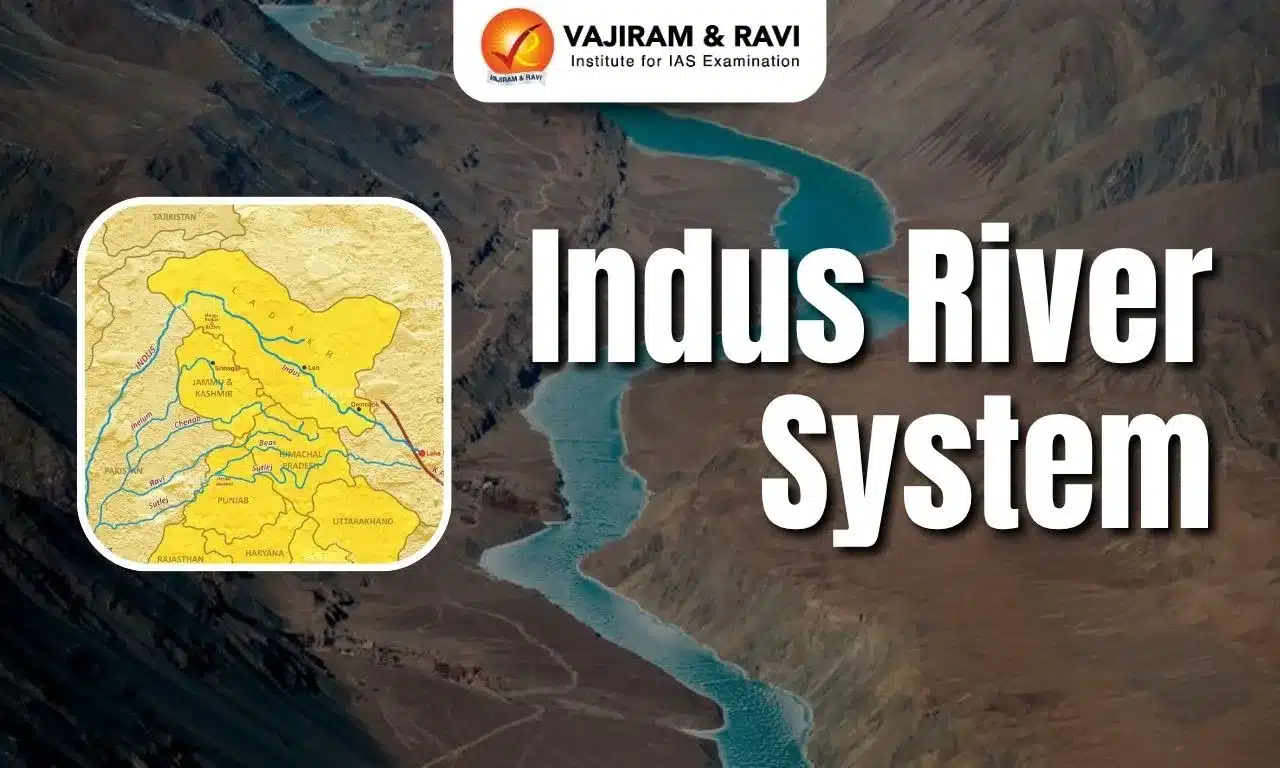
Indus River System Map
[my_image src="https://vajiramandravi.com/current-affairs/wp-content/uploads/2025/12/Indus-River-System-Map.webp" size="full" align="none" width="auto" height="443px" alt="Indus River System Map" title="Indus River System Map"]
The Indus River System is one of the largest and major river systems in the Indian subcontinent, spanning India, Pakistan, and parts of Tibet. A map of this system illustrates the course of the Indus River from its origin in the Tibetan Plateau to its delta in the Arabian Sea. It also displays the network of its major tributaries including the Jhelum, Chenab, Ravi, Beas, and Satluj rivers.
Indus River System Origin
The Indus River originates from a glacier near Bokhar Chu in the Tibetan region, within the Kailash Mountain Range, close to Mansarovar Lake. The river flows northwest and enters India’s Ladakh region at Demchok. Within India, it flows between the Karakoram and Ladakh ranges, shaping the region’s unique topography. In Tibet, the Indus River is revered and known as ‘Singi Khamban’, meaning ‘Lion’s Mouth’ due to its flow.
Indus River System Left Bank Tributaries
The left bank tributaries of the Indus River System include the Zanskar, Suru, Soan, Jhelum, Chenab, Ravi, Beas, Sutlej, and Panjnad rivers. These tributaries rise from the Himalayas, Zaskar Range, Pir Panjal, and the Kailash region, contributing major volumes of snowmelt and perennial flow to the Indus.
Zanskar River
The Zanskar River is an important left-bank tributary of the Indus, flowing through the cold desert region of Ladakh. It originates in the Zanskar Range and cuts through some of the deepest gorges of the Himalayas. Due to harsh climate and terrain, human settlements are very limited along its course.
- Originates from the Zanskar Range in Ladakh
- Joins the Indus at Nimmu (near Leh)
- Known for deep gorges and rugged terrain
- Famous for the winter Chadar Trek on its frozen surface
Suru River
The Suru River originates from the Panzella Glacier in the Ladakh region and flows through the fertile Suru Valley near Kargil. It provides essential water for agriculture in an otherwise cold and arid environment. The river’s course supports barley and apricot cultivation and sustains several villages in the valley.
- Originates from the Panzella Glacier in Ladakh
- Flows through the Suru Valley and supports local agriculture
- Major source of irrigation for Kargil region
- Drains into the Indus River downstream
Indus River
The Indus River, the primary watercourse of the Indus River System, originates from glaciers in the Kailash Range, near Mansarovar Lake in Tibet. It flows for approximately 2,880 kilometers, of which 710 kilometers pass through the Indian Union Territory of Ladakh, before continuing its course through Pakistan and Tibet. The river’s journey is shaped by diverse landscapes, including:
- The Himalayan Mountains,
- The Hindu Kush,
- The Karakoram Range,
- The semi-arid plains of Pakistan.
Jhelum River
- Tributary of the Indus River System; known as Vitusta (Rigveda), Hydaspes (Greek), and Veth (Kashmir).
- Originates from Chashma Verinag Glacier, Pir Panjal Range, Jammu & Kashmir.
- It flows through Srinagar and Wular Lake (one of India's largest freshwater lakes).
- Jhelum River travels 720 km; enters Pakistan via Baramulla and Muzaffarabad.
- Merges with the Chenab River in Pakistan.
Chenab River
- Chenab River is also known as Asskini Chandrabhaga in ancient texts.
- Formed by the confluence of Chandra and Bhaga rivers near Keylong, Himachal Pradesh.
- The River originates from glacial meltwater at Baralacha La Pass.
- Largest tributary of the Indus River System.
- Flows through India and Pakistan, where it merges with the Indus River.
Ravi River
- Ravi River is known as Iravati (ancient) and “The River of Lahore.”
- It originates near Rohtang Pass in Chamba district, Himachal Pradesh.
- Ravi River flows 720 km before merging with the Chenab in Pakistan.
- Passes through Shahdara Bagh, site of Mughal tombs (Jahangir and Noor Jahan).
- Supports agriculture between Pir Panjal and Dhauladhar Ranges.
Beas River
- Beas River originates from Beas Kund near Rohtang La Pass in Himachal Pradesh.
- The River travels 470 km through Himachal Pradesh and Punjab.
- It merges with the Satluj River in Punjab.
- Crucial for irrigation, hydroelectric power, and sustaining biodiversity.
Satluj River
- Satluj River is the longest tributary of the Indus River System.
- It Originates from Lake Rakshastal near Mansarovar, Tibet.
- Enters India through Shipki La Pass, Himachal Pradesh.
- Flows 1,450 km (1,050 km in India) through Himachal and Punjab.
- Enters Pakistan and joins the Indus River near Mithankot.
Indus River System Right Bank Tributaries
The right bank tributaries of the Indus River System include the Shyok, Gilgit, Hunza, Swat, Kunnar, Kurram, Gomal, Tochi, and Kabul rivers. These rivers rise mainly from the Karakoram, Hindu Kush, and western Himalayan ranges, bringing snowmelt and seasonal flows from Ladakh, Afghanistan, and northwest Pakistan.
1. Shyok River
The Shyok River originates from the Rimo Glacier in the Karakoram Range and flows through northern Ladakh. It widens at the confluence with the Nubra River and forms a unique V-shaped bend around the Karakoram. Its course is highly braided and dynamic due to glacial melt.
- Origin: Rimo Glacier, Karakoram Range
- Meets Nubra River in Ladakh
- Forms a distinct V-shaped bend
- Major right-bank tributary of the Indus
2. Nubra River
The Nubra River rises from the Nubra Glacier and flows through the cold desert region of the Nubra Valley. It meanders southeast and joins the Shyok River at the base of the Ladakh Range. The river supports limited agriculture and settlements in the valley.
- Origin: Nubra Glacier
- Flows through Nubra Valley
- Joins Shyok River downstream
- Supports local agriculture in Ladakh
3. Gilgit River
The Gilgit River originates from the Shandur region and flows through the Gilgit Valley in northern Pakistan. It receives water from several glaciers before meeting the Indus near Juglot. The river sustains agriculture and settlements across Gilgit-Baltistan.
- Origin: Shandur region
- Flows through Gilgit Valley
- Joins Indus near Juglot
- Supplies irrigation to mountain settlements
4. Hunza River
The Hunza River is formed by the Hispar and Batura glaciers in the Karakoram Range. Flowing through the picturesque Hunza Valley, it merges with the Gilgit River. Its waters are crucial for irrigation and glacial runoff management.
- Origin: Hispar & Batura Glaciers
- Drains the Hunza Valley
- Merges with Gilgit River
- Important for irrigation in Karakoram region
Indus River System State Covered
The Indus River originates in Tibet (China) near Lake Mansarovar and flows northwest into Ladakh (India) before entering Pakistan. In Pakistan, it passes through Gilgit–Baltistan, Khyber Pakhtunkhwa, Punjab, and Sindh, serving as the major freshwater source. Along its course, it forms fertile plains and supports extensive irrigation networks. Finally, it drains into the Arabian Sea near Karachi after traversing diverse terrains and climates.
Indus River System Features
- The Indus River is about 3,180 km long. Its drainage basin covers approximately 1.16 million square kilometers, spanning Tibet (China), India, and Pakistan.
- Originates from Bokhar Chu Glacier, near Mansarovar Lake in Tibet. Flows through Ladakh (India), Punjab (Pakistan), and merges into the Arabian Sea near Karachi.
- Right Bank Tributaries include Shyok, Gilgit, Kabul, Gomal and Left Bank Tributaries include Jhelum, Chenab, Ravi, Beas, Satluj.
- Forms fertile alluvial plains in Punjab and Sindh regions. Creates deep gorges in Ladakh and Gilgit-Baltistan.
- The Indus River System supports agriculture in India and Pakistan.
- Several dams and hydroelectric projects use Indus River System water.
- Indus Water Treaty (1960) was signed to govern water-sharing between India and Pakistan.
Indus Water Treaty 1960
- The Indus Water Treaty of 1960 is a historic agreement between India and Pakistan, mediated by the World Bank, to regulate the distribution of the Indus River System's waters.
- Under the treaty, India was allocated control over the three eastern rivers—Ravi, Beas, and Sutlej, while Pakistan was granted rights over the three western rivers—Indus, Jhelum, and Chenab.
- This agreement is widely regarded as one of the most successful water-sharing treaties, offering a structured framework for cooperation and conflict resolution between the two nations despite ongoing geopolitical tensions.
- The treaty permits India to utilize the western rivers for non-consumptive purposes, including hydropower generation, navigation, and irrigation, while ensuring an uninterrupted downstream flow to Pakistan, thereby maintaining a balance of water rights and usage.
Indus River System FAQs
Q1: Where do 5 rivers meet Indus?
Ans: Jhelum and Ravi join Chenab, Beas joins Sutlej, and then Sutlej and Chenab join to form Panjnad, 10 miles north of Uch Sharif in Muzaffar Garh district.
Q2: What are the Indus water systems?
Ans: The Indus River system comprises six rivers: Indus, Jhelum, Chenab, Ravi, Beas, and Sutlej.
Q3: Which river is called the father of rivers?
Ans: Indus River, great trans-Himalayan river of South Asia.
Q4: What are the 5 tributaries of the Indus River?
Ans: Jhelum, Chenab, Ravi, Beas, and Satluj—from the Panchnad.
Q5: What is the other name of Indus River system?
Ans: The river Indus is also known as Sindhu.
