The Peninsular Plateau of India, also known as the Indian Shield, is one of the oldest and most stable landmasses on Earth. It forms the core of the Indian subcontinent and dominates the geographical landscape of central and southern India. Its geological antiquity, mineral wealth, diverse physiographic divisions, and ecological significance make it an essential part of India. The plateau has shaped India’s river systems, agriculture, settlement patterns, industrial development, and biodiversity over millions of years.
Peninsular Plateau of India Features
The Peninsular Plateau stands out due to its unique terrain, geological stability, and mineral-rich composition.
- The plateau covers nearly 16 lakh sq km, representing almost 50% of India’s total landmass.
- It is composed primarily of crystalline, igneous, and metamorphic rocks, dating back to the Archean and Proterozoic ages (over 2.5 billion years old).
- The plateau is roughly triangular in shape, drained by both east-flowing and west-flowing rivers, creating deep valleys, escarpments, and basins.
- The Peninsular Plateau is bounded by the Aravalli Range, Vindhya, Satpura, Barmer, and Rajmahal Hills in the north; the Western Ghats in the west; and the Eastern Ghats in the east.
- It consists of numerous plateaus, uplands, hill ranges, forest belts, and fertile valleys formed by tectonic movements and prolonged erosion.
- The region is rich in minerals resources such as iron ore, coal, manganese, bauxite, gold, mica, making it India’s “mineral heartland.”
Peninsular Plateau of India Geological Formation
The geological evolution of the Peninsular Plateau is linked to tectonic activity, volcanic events, and the breakup of ancient continents.
- Part of the Gondwana supercontinent, the plateau separated due to continental drift about 135 million years ago.
- The foundation of the plateau is formed by some of the world’s oldest rocks, comparable to those found in Western Australia and South Africa.
- Large igneous eruptions known as Deccan Trap volcanic events (around 60-68 million years ago) formed extensive basaltic layers, especially in Maharashtra.
- Lineaments, faults, and rift valleys such as the Narmada-Son Lineament and Narmada-Tapti Rift Valley are prominent tectonic features.
- Weathering, denudation, and fluvial erosion have shaped its current topography over millions of years.


Peninsular Plateau of India Divisions
The Peninsular Plateau is divided into several physiographic units, each with distinct geological structure, river systems, soil types, ecology, and agricultural patterns. Below are the Major Divisions of the Peninsular Plateau of India
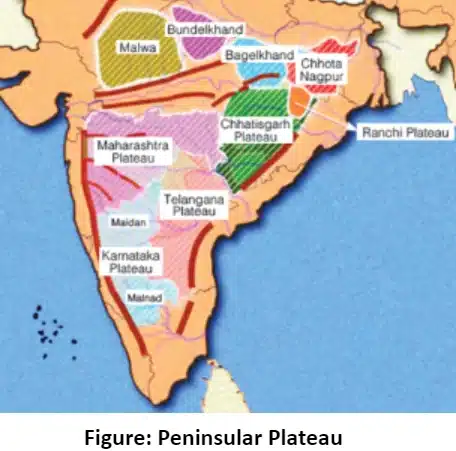
Marwar Upland
The Marwar Upland lies in the northwestern part of the Peninsular Plateau and forms a transitional zone between the Thar Desert and the Aravalli Range. It is characterized by semi-arid climate, rocky terrain, and ancient residual hills.
- Location: Western Rajasthan, mainly Jodhpur, Pali, Nagaur, Barmer regions.
- Topography:
- Rocky uplands, pediments, and residual hills.
- Elevation ranges between 250-500 m.
- Rivers: Seasonal rivers such as Luni, Sukri, and Bandi.
- Geological Composition: Predominantly Aravalli schists, gneisses, quartzite, and granite.
- Flora & Fauna:
- Xerophytic vegetation – Khejri, Acacia, Ber, thorn scrub.
- Wildlife: Chinkara, Desert fox, Blackbuck.
- Major Crops: Bajra, Jowar, Pulses, Mustard, and limited wheat in irrigated areas.
- States Covered: Rajasthan.
Central Highlands
The Central Highlands form the northern segment of the Peninsular Plateau, extending from the Aravallis to the eastern part of Madhya Pradesh. They include important plateaus and river basins.
- Location: Rajasthan, Madhya Pradesh, parts of Uttar Pradesh.
- Topography:
- Elevation 300-600 m, dissected plateaus.
- Slopes eastward towards the Gangetic plains.
- Rivers: Chambal, Banas, Sind, Betwa, Ken.
- Geological Composition: Granite-gneiss, Vindhyan sedimentary rocks (sandstone, shale, limestone).
- Flora & Fauna: Dry deciduous forest – Teak, Salai, Palash.
- Fauna: Leopard, Nilgai, Sloth bear.
- Major Crops: Wheat, Soybean, Mustard, Pulses, Cotton (western part).
- States Covered: Rajasthan, Madhya Pradesh, Uttar Pradesh.
Bundelkhand Upland
Bundelkhand Upland is a rugged region between the Yamuna and Narmada river systems known for granite outcrops, uneven terrain, and low water availability.
- Location: Southern Uttar Pradesh & Northern Madhya Pradesh (Jhansi, Banda, Chhatarpur).
- Topography:
- Highly eroded upland, rocky plateau, inselbergs.
- Average elevation 300-400 m.
- Rivers: Betwa, Dhasan, Ken, Sonar.
- Geological Composition: Ancient Bundelkhand granites, gneisses, quartzite.
- Flora & Fauna:
- Thorn & dry deciduous vegetation.
- Wildlife includes Nilgai, Wild Boar, Indian Wolf.
- Major Crops: Gram, Wheat, Bajra, Urad, limited paddy.
- States Covered: Madhya Pradesh, Uttar Pradesh.
Malwa Plateau
The Malwa Plateau is a fertile volcanic region with black soil, forming an important agricultural zone in central India.
- Location: Western Madhya Pradesh & southeastern Rajasthan.
- Topography:
- Flat to gently undulating plateau, elevation 500-600 m.
- Northern boundary marked by Chambal ravines.
- Rivers:
- Western Drainage (towards the Arabian Sea): Includes Narmada, Tapi, and Mahi, which flow westward and drain into the Arabian Sea.
- Eastern Drainage (towards the Bay of Bengal): Includes Chambal and Betwa, which flow northeast and join the Yamuna, ultimately draining into the Bay of Bengal.
- Geological Composition: Basaltic lava flows from Deccan volcanism, which formed Black cotton soil.
- Flora & Fauna:
- Dry deciduous forest – Teak, Butea, Neem.
- Fauna: Chital, Indian fox, Hyena.
- Major Crops: Soybean (largest producer), Wheat, Cotton, Sugarcane, Maize.
- States Covered: Madhya Pradesh, Rajasthan and some parts of Gujarat
Baghelkhand Plateau
The Baghelkhand Plateau lies in eastern Madhya Pradesh and is known for rugged topography, dense forest cover, and important mineral reserves.
- Location: Eastern Madhya Pradesh, Uttar Pradesh & northern Chhattisgarh.
- Topography: Dissected plateau, steep escarpments, elevation 300-600 m.
- Rivers: Son, and Mahanadi
- Geological Composition: Vindhyan & Gondwana sediments, sandstone, limestone, shales.
- Flora & Fauna:
- Moist deciduous forests – Sal, Bamboo.
- Animals: Tiger, Leopard, Sambar, Indian Bison.
- Major Crops: Paddy, Wheat, Pulses, minor millets.
- States Covered: Madhya Pradesh, Uttar Praedesh, Chhattisgarh.
Chotanagpur Plateau
The Chotanagpur Plateau is India’s mineral heartland, rich in coal, iron ore, mica, bauxite, and copper. It supports major industrial belts.
- Location: Jharkhand, northern Odisha, eastern Chhattisgarh, West Bengal border.
- Topography:
- Uplands, valleys, and highest peak Parasnath (1365 m).
- Ranchi, Hazaribagh, Palamu uplands.
- Rivers: Damodar, Subarnarekha, Koel, Sankh.
- Geological Composition: Archaean granites and Gondwana coalfields.
- Flora & Fauna:
- Tropical dry & moist deciduous – Sal, Bamboo, Mahua.
- Fauna: Elephant, Leopard, Sloth Bear.
- Major Crops: Paddy, Maize, Oilseeds, Pulses.
- States Covered: Jharkhand, Odisha, Chhattisgarh, West Bengal.
Meghalaya Plateau
The Meghalaya Plateau is a detached fragment of the Peninsular block, famous for heavy rainfall, limestone caves, and biodiversity.
- Location: Meghalaya (Khasi, Garo, Jaintia Hills).
- Topography:
- High hills (avg. 1200-1500 m), deep valleys.
- Receives highest rainfall at Mawsynram & Cherrapunji.
- Rivers: Umngot, Myntdu, Simsang, seasonal streams.
- Geological Composition: Gneiss, schist, sandstone, limestone, rich cave systems.
- Flora & Fauna:
- Evergreen forests – Orchids, Pine, Bamboo.
- Fauna: Hoolock gibbon, Clouded leopard, Elephants.
- Major Crops: Jhum crops, Potatoes, Turmeric, Oranges, spices.
- States Covered: Meghalaya.
Deccan Plateau
The Deccan Plateau is the largest and most prominent part of the Peninsular Plateau, covering almost the entire southern part of India. It is a volcanic plateau formed primarily during the Cretaceous period due to massive basaltic lava flows, commonly known as the Deccan Traps.
- Location: Bounded by the Western Ghats on the west, Eastern Ghats on the east, and the Satpura and Vindhya ranges in the north.
- Topography
- Average elevation ranges from 500 to 1000 meters above sea level.
- Broad, gently sloping plateau surface, mostly towards the east.
- Western Ghats form a steep escarpment with narrow coastal plains; Eastern Ghats are discontinuous and eroded.
- Contains hill ranges like Balaghat, Nilgiri, Anaimalai, and Cardamom Hills.
- Geological Composition
- Dominated by basaltic lava flows of the Deccan Traps.
- Some areas with granite, gneiss, schist, and laterite formations.
- Rich in minerals: iron ore, manganese, bauxite, and limestone.
- Rivers and Drainage
- East-flowing rivers: Godavari, Krishna, Kaveri, Tungabhadra, Bhima, Pennar (drain into Bay of Bengal).
- West-flowing rivers: Some short rivers along Western Ghats, e.g., Mandovi, Sharavathi (drain into Arabian Sea).
- Provides hydropower potential at dams like Srisailam, Nagarjuna Sagar, and Tungabhadra.
- Soil and Agriculture
- Black soil (Regur): Ideal for cotton cultivation.
- Red and laterite soils: Support millets, pulses, oilseeds.
- Alluvial soils along river valleys: Rice and sugarcane.
- Major crops: Cotton, Jowar, Ragi, Groundnut, Sugarcane, Paddy, Millets.
- Horticulture: Coffee, Rubber, Spices (especially in Karnataka, Kerala, and Tamil Nadu).
- Flora and Fauna
- Dry and moist deciduous forests in plateau areas.
- Western Ghats: Biodiversity hotspot with tropical evergreen forests.
- Wildlife includes Tiger, Leopard, Gaur, Elephant, Nilgiri Tahr, Sloth Bear.
- Economic Significance
- Agriculture: Major cotton, sugarcane, and food grain-producing region.
- Minerals: Iron ore (Karnataka, Goa), Manganese (Maharashtra, Karnataka), Bauxite (Karnataka, Odisha).
- States Covered: Maharashtra, Karnataka, Telangana, Andhra Pradesh, Tamil Nadu, Kerala, Chhattisgarh
Major Hillls of Peninsular Plateau of India

The Peninsular Plateau of India consists of several ancient hill ranges that influence river systems, climate, and biodiversity. These hills include both continuous ranges like the Western Ghats and discontinuous ranges like the Eastern Ghats, along with isolated highlands across central and southern India.
| Major Hillls of Peninsular Plateau of India | |||
| Hill Range | Location / States | Highest Peak | Significance |
|
Aravalli Hills |
Rajasthan, Delhi |
Guru Shikhar (1,722 m) |
Oldest fold mountains; influence desert ecology |
|
Vindhya Range |
Madhya Pradesh, Uttar Pradesh, Rajasthan |
1,100 m |
Natural divide between north & south India |
|
Madhya Pradesh, Maharashtra, Chhattisgarh |
Dhupgarh (1,350 m) |
Source of Narmada river; rich forests |
|
|
Western Ghats |
Maharashtra, Goa, Karnataka, Kerala, Tamil Nadu |
Anamudi (2,695 m) |
UNESCO Heritage Site; biodiversity hotspot |
|
Eastern Ghats |
Odisha, Andhra Pradesh, Tamil Nadu, Karnataka |
Jindhagada or Arma Konda (1,690 m, Araku Valley) |
Discontinuous hills; many rivers originate |
|
Tamil Nadu, Kerala, Karnataka |
Doddabetta (2,637 m) |
Hill station & tourism; rich flora & fauna |
|
|
Anaimalai Hills |
Tamil Nadu, Kerala |
Anamudi (2,695 m) |
Coffee plantations; wildlife habitats |
|
Kerala |
South Cardamom (1,670 m) |
Spices cultivation; tropical forests |
|
|
Meghalaya Hills |
Meghalaya (Khasi, Garo, Jaintia Hills) |
Shillong Peak (1,965 m) |
Wettest region; unique biodiversity |
Peninsular Plateau of India Mineral Resources
The Peninsular Plateau of India is rich in metallic, non-metallic, and fuel minerals due to its ancient geological formations like Archaean rocks, Deccan Traps, and Gondwana sediments. These minerals are crucial for India’s industrial growth, energy production, and infrastructure development.
- Chotanagpur Plateau: Coal, iron, mica, copper.
- Malwa & Bundelkhand Plateaus: Limestone, bauxite, some iron ore.
- Karnataka Plateau: Gold, manganese, bauxite, granite.
| Mineral Resources of the Peninsular Plateau | |
| Mineral | Major Producing States |
|
Iron Ore |
Odisha, Jharkhand, Chhattisgarh, Karnataka, Goa |
|
Manganese |
Madhya Pradesh, Maharashtra, Karnataka |
|
Copper |
Jharkhand (Singhbhum), Rajasthan (Khetri) |
|
Bauxite |
Maharashtra, Odisha, Jharkhand, Gujarat |
|
Limestone |
Madhya Pradesh, Rajasthan, Chhattisgarh, Andhra Pradesh |
|
Coal |
Jharkhand, Chhattisgarh, Odisha, Madhya Pradesh |
|
Gold |
Karnataka (Kolar, Hutti) |
|
Mica |
Jharkhand, Bihar, Andhra Pradesh |
|
Graphite |
Jharkhand, Tamil Nadu |
|
Granite & Marble |
Rajasthan, Karnataka |
|
Diamond |
Madhya Pradesh (Panna) |
|
Gemstones |
Andhra Pradesh, Rajasthan, Karnataka |
Peninsular Plateau of India Economic Significance
The economic significance of the Peninsular Plateau of India has been listed below:
- Fertile soils like black soil and alluvial soils support cotton, wheat, rice, sugarcane, millets, and oilseeds.
- Rivers of the plateau provide irrigation through dams and canals, supporting agriculture.
- Rich in iron, manganese, bauxite, copper, coal, mica, limestone, and gold, making it a mineral hub.
- Mineral resources have led to the growth of steel plants, cement factories, and mining-based industries.
- Plateau forests provide timber, medicinal plants, and other forest products.
- Western and Eastern Ghats host biodiversity hotspots, contributing to eco-tourism and research.
- Rivers are suitable for hydroelectric power projects, e.g., Srisailam, Nagarjuna Sagar.
- Coal deposits in Jharkhand, Chhattisgarh, and Odisha support thermal power plants.
- Hill stations, rivers, waterfalls, and scenic plateaus attract tourism.
Peninsular Plateau of India Challenges
Several environmental and ecological challenges faced by the Peninsular Plateau of India has been discussed below:
- Deforestation – India’s forest cover on the plateau is around 21-23%, lower than the national average in some states. Western Ghats and Chotanagpur forests have lost 10-15% of original forest cover in the past two decades due to logging, mining, and urban expansion.
- Soil Erosion – Over 35% of Bundelkhand and Malwa plateau areas are prone to soil erosion due to overgrazing, deforestation, and unsustainable farming.
- Water Scarcity – Western plateau regions like Marwar and parts of Telangana receive less than 500-800 mm annual rainfall, leading to recurrent droughts and low groundwater levels.
- Mining Impacts – Jharkhand and Chhattisgarh account for over 40% of India’s coal production, causing land degradation, deforestation, and siltation in rivers like Damodar.
- Biodiversity Loss – Western Ghats are a UNESCO World Heritage site, yet nearly 150 species are critically endangered, including the lion-tailed macaque and Malabar civet.
- Air Pollution and Water Pollution – Industrial regions in Odisha, Jharkhand, and Chhattisgarh contribute to high levels of suspended particulate matter, and heavy metal contamination in rivers like Brahmani and Mahanadi.
- Climate Change Effects – Plateau areas have recorded temperature rise of 0.6-0.8°C over the last 50 years, impacting agriculture (e.g., reduced yields of millets, pulses) and increasing drought frequency.
- Invasive Species – Plants like Lantana camara have invaded over 20% of degraded forest areas in Chhattisgarh and Madhya Pradesh, affecting local flora.
- Landslides and Flooding – Western Ghats and Meghalaya Hills receive annual rainfall exceeding 2,500-11,000 mm, causing frequent landslides and flash floods during monsoon season.
Way Forward
- Afforestation and Forest Management: Increase forest cover in degraded areas; India’s forest cover is 21.7%, lower than the ideal 33%, e.g., Western Ghats restoration projects.
- Soil and Water Conservation: Adopt watershed management and rainwater harvesting; Bundelkhand has implemented Jaiv Krishi practices to reduce erosion.
- Sustainable Mining Practices: Enforce eco-friendly mining and land reclamation, e.g., coal mining in Jharkhand and Odisha is being regulated under the Mine Environment & Safety Act.
- Biodiversity Protection: Strengthen protected areas; the Nilgiri Biosphere Reserve conserves endemic species like lion-tailed macaque and Malabar civet.
- Climate Change Adaptation: Promote drought-resistant crops and water-efficient irrigation, e.g., Telangana’s micro-irrigation schemes reduce water stress during erratic monsoons.
- Pollution Control Measures: Implement industrial emission and effluent regulations; e.g., Odisha’s steel belt now follows stricter CPCB standards.
![]() Last updated on June, 2026
Last updated on June, 2026
→ UPSC Prelims Result 2026 is now out.
→ UPSC IFoS Prelims Result 2026 is now out.
→ Enroll in Vajiram & Ravi’s UPSC Mains Test Series 2026 for structured answer writing practice, expert evaluation, and exam-oriented feedback.
→ Join Vajiram & Ravi’s UPSC Mentorship Program 2026 for personalized guidance, strategy planning, and one-to-one support from experienced mentors.
→ Join Vajiram & Ravi’s UPSC Mentorship Program 2027 for personalized guidance, strategy planning, and one-to-one support from experienced mentors.
→ UPSC Prelims Provisional Answer Key 2026 out for GS Paper 1 and CSAT.
→ UPSC Prelims Question Paper 2026 Out, Download GS Paper 1 PDF conducted on 24th May 2026.
→ UPSC Mains 2026 will be conducted from 21st August 2026 onwards, and UPSC Prelims 2027 will be held on 23rd May 2027.
→ UPSC Final Result 2025 is now out.
→ UPSC has released UPSC Toppers List 2025 with the Civil Services final result on its official website.
→ Anuj Agnihotri secured AIR 1 in the UPSC Civil Services Examination 2025.
→ UPSC Notification 2026 & UPSC IFoS Notification 2026 is now out on the official website at upsconline.nic.in.
→ UPSC Calendar 2027 has been released.
→ Check out the latest UPSC Syllabus 2026 here.
→ The UPSC Selection Process is of 3 stages-Prelims, Mains and Interview.
→ Shakti Dubey secures AIR 1 in UPSC CSE Exam 2024.
→ Also check Best UPSC Coaching in India
Peninsular Plateau FAQs
Q1. Why is the Peninsular Plateau important for the UPSC exam?+
Q2. Which is the largest division of the Peninsular Plateau?+
Q3. Which region of the plateau is richest in minerals?+
Q4. What type of rocks dominate the Peninsular Plateau?+
Q5. Why does the plateau have east-flowing rivers?+
Tags: geography indian geography peninsular plateau