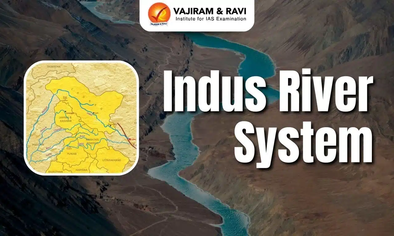
The Indus River System is one of South Asia’s major river systems, supporting agriculture, hydropower, biodiversity and human settlements across a vast transboundary basin. Originating in the Tibetan Plateau near Mount Kailash, it flows through Ladakh and Pakistan before draining into the Arabian Sea. Its major tributaries include the Jhelum, Chenab, Ravi, Beas and Sutlej, along with mountain rivers such as the Zanskar, Shyok and Gilgit. The basin encompasses diverse landscapes, including glaciers, high-altitude valleys, fertile plains, wetlands and delta ecosystems.
Despite its importance for water security and economic development, the Indus River System faces challenges from pollution, water scarcity, ecological degradation and climate change. Sustainable management requires efficient irrigation, ecosystem conservation, improved water governance and transboundary cooperation.
Indus River System Overview
The Indus is a major transboundary river of Asia whose mountain-fed waters sustain settlements, irrigation networks, hydropower projects and ecosystems across India and Pakistan.
- River system: The Indus River and its tributaries form one of the major drainage systems of the Indian subcontinent.
- Total length: The Central Water Commission describes the river as approximately 2,880 km long.
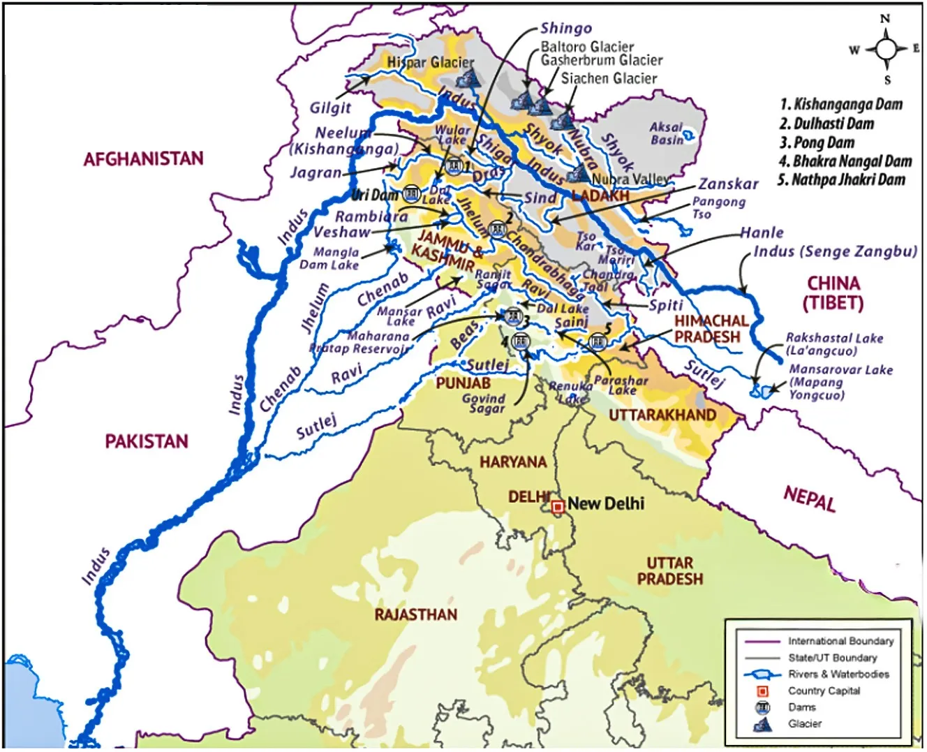
- Major tributaries: The Jhelum, Chenab, Ravi, Beas and Sutlej are the major tributaries of the Indus River System.
- International significance: The river basin extends across China, India, Pakistan and parts of Afghanistan through the wider drainage network.
Indus River System Origin
The Indus rises in the high-altitude Tibetan Plateau near Mount Kailash, where snow and glacial melt contribute to the river’s upper reaches.
- The Central Water Commission identifies Bokhar Chu Glacier on the northern slopes of Mount Kailash as the river’s source.
- In Tibet, the river is also known as Singi Khamban, commonly translated as the “Lion’s Mouth".
- From its source region, the river flows generally northwestward through Tibet before entering the Ladakh region of India.
- It then follows a long course through high mountain terrain and receives water from glacial tributaries. It empties into the Arabian Sea through a delta in Pakistan’s Sindh region.


Indus River System Course and Physical Features
The Indus follows a varied course through elevated plateaus, narrow mountain valleys, deep gorges, plains and a delta, reflecting the diverse relief of its drainage basin.
- Upper course - Tibetan Plateau: The Indus River System begins in a high-altitude environment characterised by cold conditions, sparse vegetation and snow-covered mountains. Its early course is influenced by glaciers, seasonal snowmelt and the rugged terrain of the Tibetan Plateau.
- Middle course – Ladakh and the Trans-Himalayan region: In Ladakh, the Indus flows through a high-altitude, largely arid landscape between the Ladakh and Zanskar ranges. The river passes near Leh and receives water from tributaries draining the Karakoram and surrounding mountain systems.
- Mountain gorges and steep valleys: As the river continues towards Pakistan, it cuts through mountainous terrain, including deep gorges near the Nanga Parbat massif. These steep reaches contribute to the river’s hydropower potential and create difficult conditions for transport and infrastructure development.
- Lower course – Plains and delta: After passing through the mountainous regions of Pakistan, including Gilgit-Baltistan and Khyber Pakhtunkhwa, the Indus flows through the Punjab and Sindh plains. Its gradient decreases, encouraging sediment deposition across floodplains before it forms a delta and drains into the Arabian Sea.
Indus River System Basin in India and State-Wise Distribution
The Indian portion of the Indus basin spans several northern states and Union Territories, with the largest share of its drainage area located in Jammu and Kashmir. The Central Water Commission’s basin profile gives the following distribution of drainage area in India.
| State or Union Territory | Drainage area (sq. km) |
|
Jammu & Kashmir and Ladakh |
193,762 |
|
Himachal Pradesh |
51,356 |
|
Punjab |
50,304 |
|
Rajasthan |
15,814 |
|
Haryana |
9,939 |
|
Chandigarh |
114 |
|
Total |
321,289 |
Indus River System Hydrology
The Indus is a perennial, mountain-fed river whose discharge reflects snowmelt, glacier melt, rainfall and seasonal changes across its extensive high-altitude drainage basin.
- Catchment area in India: approximately 321,289 sq. km.
- The length of the Indus River in India is 1,114 km.
- Average water resource potential: 73,310 million cubic metres (MCM) in the basin-extent table.
- Utilisable surface water resource: 46,000 MCM.
- Total live storage capacity of listed projects: 16,322 MCM, including completed projects and projects under construction.
Indus River System Major Tributaries
The Indus River receives water from tributaries originating in the Himalayas, Karakoram, Hindu Kush and adjoining ranges, making the tributary network central to the basin’s hydrology.
Left-Bank Tributaries of the Indus River
The left-bank tributaries join the Indus from its left side when viewed in the downstream direction. Several major rivers of the Indus system drain the Himalayan and Tibetan regions.
- Zanskar River: Originating in the high-altitude region of Ladakh, it joins the Indus near Nimmu.
- Sutlej River: Rising in the Tibetan Plateau, it flows through Himachal Pradesh and Punjab and forms an important part of the Indus River System.
- Beas River: Originating in Himachal Pradesh, it joins the Sutlej at Harike in Punjab.
- Ravi River: Rising in Himachal Pradesh, it is one of the eastern rivers associated with the Indus system.
- Chenab River: Formed by the Chandra and Bhaga rivers in Himachal Pradesh, it flows through the Jammu region and is a major tributary of the Indus system.
- Jhelum River: Originating in the Kashmir Valley, it is one of the five major rivers traditionally associated with Punjab.
Right-Bank Tributaries of the Indus River
The right-bank tributaries enter the Indus from its right side when viewed in the downstream direction. Important examples include rivers draining the Karakoram and Hindu Kush mountain regions.
- Shyok River: Originating in the Karakoram region, it carries mountain meltwater into the upper Indus system.
- Shigar River: Draining the Karakoram mountains, it contributes glacial meltwater to the Indus.
- Gilgit River: Flowing through the northern mountain region, it joins the Indus in the upper basin.
- Kabul River: Originating in the Hindu Kush region, it flows through Afghanistan and joins the Indus near Attock in Pakistan.
Indus River System Glaciers Associated
Glaciers and seasonal snowfields in the upper Indus basin act as natural water stores, releasing meltwater that supports river flow during warmer periods. The river drains numerous glaciers and mountain slopes in the Karakoram, Ladakh, Zanskar and Himalayan ranges. Important glacier-fed areas associated with the wider Indus system include:
- Bokhar Chu Glacier: The source of the Indus near Mount Kailash.
- Siachen Glacier region: Meltwater from the Karakoram contributes to the Shyok–Nubra river network.
- Karakoram glaciers: Supply meltwater to tributaries such as the Shyok and Shigar.
- Himalayan and Trans-Himalayan snowfields: Seasonal snowmelt feeds the Indus and its tributaries, affecting seasonal river discharge.
Indus River System Major Dams and Hydropower Projects
Dams and water-control structures across the Indus basin support electricity generation, irrigation, flood management and water storage, although their operation is shaped by river conditions and treaty provisions.
| Dam or project | River | State or region | Main purpose |
|
Nimoo Bazgo Dam |
Indus |
Ladakh |
Hydroelectric power |
|
Baglihar Dam |
Chenab |
Jammu and Kashmir |
Hydroelectric power |
|
Salal Dam |
Chenab |
Jammu and Kashmir |
Hydroelectric power |
|
Dulhasti Dam |
Chenab |
Jammu and Kashmir |
Hydroelectric power |
|
Uri-II Dam |
Jhelum |
Jammu and Kashmir |
Hydroelectric power |
|
Kishanganga Project |
Kishanganga |
Jammu and Kashmir |
Hydroelectric power |
|
Bhakra Dam |
Sutlej |
Himachal Pradesh |
Hydropower and irrigation |
|
Pong Dam |
Beas |
Himachal Pradesh |
Hydropower and irrigation |
|
Pandoh Dam |
Beas |
Himachal Pradesh |
Water diversion and hydropower system |
|
Ranjit Sagar Dam |
Ravi |
Punjab |
Flood management, hydropower and irrigation |
Indus River System Flora and Fauna
The Indus basin supports diverse ecosystems, ranging from cold deserts and alpine habitats to riverine wetlands, agricultural plains and coastal delta environments.
Flora of the Indus River System
Vegetation varies according to altitude, temperature, rainfall and water availability.
- Alpine and subalpine vegetation: Mountain slopes support grasses, herbs, shrubs and other cold-adapted plants.
- Cold-desert vegetation: Parts of Ladakh have sparse vegetation, including hardy shrubs and grasses adapted to limited moisture.
- Riverine vegetation: Trees, reeds and other plants grow along riverbanks and in suitable floodplain habitats.
- Wetland vegetation: Marshes and lakes support aquatic plants and vegetation that provide shelter and food for wildlife.
- Delta vegetation: Wetland and salt-tolerant plants occur in suitable coastal habitats near the Indus delta.
Fauna of the Indus River System
The river system and its surrounding habitats provide shelter for mammals, birds, fish, reptiles and other aquatic organisms.
- Snow leopard: Associated with high-altitude mountain habitats in the wider upper Indus region.
- Himalayan brown bear: Found in parts of the high mountain landscape.
- Himalayan ibex: A mountain ungulate adapted to steep, rocky terrain.
- Waterbirds: Riverbanks, lakes and wetlands provide feeding and breeding habitats for numerous resident and migratory birds.
- Fish: Rivers and tributaries support freshwater fish populations, although species composition varies by location and water conditions.
- Indus River dolphin: A threatened freshwater dolphin associated mainly with the lower Indus in Pakistan.
Indus River System Importance
The Indus River System is essential to water security, agriculture, energy production, biodiversity and regional livelihoods, making its sustainable management important for millions of people.
- Agricultural importance: The Indus River System supplies water to extensive irrigation networks, particularly across the plains of Pakistan and parts of northwestern India. Irrigation supports crops, livestock and rural livelihoods in regions where rainfall is often insufficient or irregular.
- Hydroelectric power: The steep gradients of the upper Indus and its tributaries offer considerable potential for hydropower. Projects on the Indus, Chenab, Jhelum, Ravi, Beas and Sutlej contribute to electricity generation.
- Drinking water and domestic use: River water and connected groundwater resources support towns, villages and settlements across the basin. Reliable supplies are important for household consumption, sanitation and public health.
- Industrial and economic activity: Water supports industries, energy infrastructure and other economic activities. Changes in availability or quality can therefore affect employment, production and regional development.
- Ecological significance: The Indus River System sustains wetlands, floodplains, fish populations and river-dependent wildlife. Seasonal flows and sediment transport also help maintain habitats and ecological processes downstream.
- Historical and cultural significance: The Indus is closely associated with the ancient Indus Valley Civilisation, one of the major urban civilisations of the ancient world. The river continues to shape settlement patterns, cultural landscapes and regional identities.
- Strategic and transboundary importance: Because the basin crosses international boundaries, its management is linked to diplomacy, water-sharing arrangements and regional cooperation. Effective coordination is essential for addressing shared water challenges.
Indus River System Challenges
The Indus basin faces growing pressure from water demand, pollution, infrastructure development, ecological degradation and climatic variability across its upstream and downstream regions.
- Water scarcity: Growing populations, irrigation requirements, urbanisation and industrial demand place pressure on available water resources. Uneven distribution and inefficient use can intensify shortages, particularly during dry periods.
- Pollution: Untreated wastewater, industrial discharges, agricultural chemicals and solid waste can degrade river water quality. Pollution threatens aquatic organisms and increases the cost of providing safe water.
- Glacier and snow changes: Changes in temperature, snowfall and glacier mass can alter the timing and amount of meltwater entering the river system. These changes make long-term water planning more uncertain.
- Ecosystem degradation: Wetland loss, riverbank development, altered flow regimes and habitat fragmentation can weaken biodiversity. Reduced environmental flows may also affect fish populations and other river-dependent species.
- Sedimentation: Mountain rivers transport large quantities of sediment. Sediment accumulation can reduce reservoir storage, affect infrastructure and alter river channels, creating additional management and maintenance challenges.
- Transboundary water management: The Indus system is shared across countries, making water allocation and infrastructure management important diplomatic issues. Cooperation requires reliable data, transparent communication and adherence to applicable agreements.
Indus River System and Climate Change
Climate change may affect the Indus through rising temperatures, shifting precipitation patterns, changing snow and glacier melt, and greater uncertainty in seasonal water availability.
Major climate-related impacts
- Glacier retreat: Continued warming can reduce glacier mass and alter the timing of meltwater release.
- Changes in snowmelt: Earlier melting may shift seasonal river flows and affect the availability of water during periods of peak demand.
- Floods and droughts: The basin experiences seasonal variation in water availability. Heavy rainfall, rapid snowmelt and extreme events can increase flood risks, while prolonged dry periods may reduce supplies for agriculture and households.
- Water stress: Changes in precipitation and seasonal flows may aggravate shortages in already water-stressed areas.
- Agricultural impacts: Uncertain irrigation supplies can affect crop planning, productivity and farmers’ incomes.
- Ecosystem disruption: Changes in temperature and river flow can affect wetlands, aquatic habitats and species dependent on seasonal water conditions.
Indus River System Way Forward
Sustainable management of the Indus requires coordinated water governance, efficient irrigation, pollution control, ecosystem protection and climate-resilient planning across the entire river basin.
- Improve irrigation efficiency: Promoting micro-irrigation where suitable, repairing canal systems, reducing conveyance losses and encouraging water-efficient agricultural practices can help meet demand with less wastage.
- Strengthen pollution control: Governments should improve wastewater treatment, enforce industrial discharge standards, reduce agricultural runoff and monitor river water quality regularly.
- Protect glaciers and mountain ecosystems: Reducing black carbon emissions, protecting mountain habitats and monitoring glaciers and glacial lakes can help improve understanding of climate-related risks. Early-warning systems should be strengthened in vulnerable areas.
- Improve flood and drought preparedness: Integrated forecasting, hydrological monitoring, risk mapping and community-based disaster preparedness can reduce damage from floods, droughts and sudden changes in river flows.
- Encourage sustainable groundwater use: Surface water and groundwater should be managed together. Monitoring groundwater extraction, protecting recharge areas and preventing contamination can improve resilience during periods of reduced river supply.
- Maintain environmental flows: Water planning should account for the needs of wetlands, fish and other river-dependent species. Protecting natural flow patterns and restoring degraded habitats can strengthen the ecological health of the basin.
- Improve transboundary cooperation: Countries sharing the basin should support transparent data exchange, scientific monitoring, dialogue and the peaceful implementation of applicable water-sharing arrangements.
- Use climate-informed planning: Water infrastructure and agricultural strategies should be designed around a range of possible future conditions. Updated climate projections, basin-wide assessments and flexible operating rules can help reduce vulnerability.
Indus River System UPSC PYQs
Q1: Present an account of the Indus Water Treaty and examine its ecological, economic and political implications in the context of changing bilateral relations. (UPSC Mains 2016)
Q2: With reference to the Indus river system, of the following four rivers, three of them pour into one of them, which joins the Indus directly. Among the following, which one is such a river that joins the Indus directly? (UPSC Prelims 2021)
(a) Chenab
(b) Jhelum
(c) Ravi
(d) Sutlej
Ans: (d)
Q3: Consider the following pairs
Glacier – River
- Bandarpunch – Yamuna
- Bara Shigri – Chenab
- Milam – Mandakini
- Siachen – Nubra
- Zemu – Manas
Which of the pairs given above are correctly matched?
(a) 1, 2 and 4
(b) 1, 3 and 4
(c) 2 and 5
(d) 3 and 5
Ans: (a)

 Last updated on Oct, 2026
→ UPSC 2027 Notification will be released on 13 January 2027 at upsconline.nic.in.
→ Check Nobel Prize 2026 Winners List here.
→ Download PIB PRiSM Monthly Magazine 2026 here.
→ Check UPSC Monthly Current Affairs Magazine The Recitals here.
→ Check out the latest UPSC Syllabus here.
→ Download UPSC Model Answers for Mains 2026
→ UPSC Mains Question Paper 2026 is out now for Essay & GS Paper 1, 2, 3 & 4.
→ UPSC Calendar 2027 has been released.
→ Enroll in Vajiram & Ravi’s UPSC Mains Test Series 2027 for structured answer writing practice, expert evaluation, and exam-oriented feedback.
→ Join Vajiram & Ravi’s UPSC Mentorship Program 2027 for personalized guidance, strategy planning, and one-to-one support from experienced mentors.
→ Go through the UPSC Mains Previous Year Papers to enhance your preparation.
→ UPSC has released UPSC Toppers List 2025 with the Civil Services final result on its official website.
→ Also check Best UPSC Coaching in India
Indus River System FAQs
Q1. What is the Indus River called in India?+
Q2. What are the 6 rivers of the Indus River System?+
Q3. Why is the Indus River important for the economy?+
Q4. Why is the Indus River important to India?+
Q5. What is the nickname of the Indus River?+
Tags: indus river system quest UPSC Geography Notes