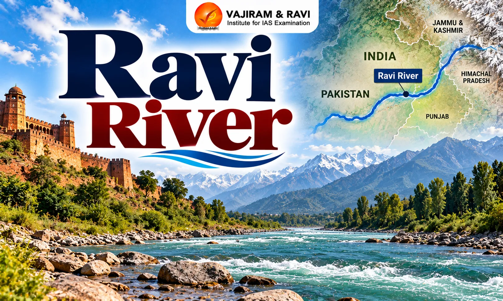
The Sutlej River is one of the major rivers of the Indus River system, originating near Lake Rakshastal on the Tibetan Plateau before flowing through Himachal Pradesh, Punjab and Pakistan. Historically known as Shatadru or Shutudri, it traverses deep Himalayan valleys and receives important tributaries, including the Spiti, Baspa and Beas rivers.
The Sutlej River supports agriculture, hydropower generation and regional water security through major projects such as Bhakra Dam, Nathpa Jhakri and Karcham Wangtoo. Its reservoirs and associated wetlands also contribute to water storage and biodiversity. However, hydropower development, pollution, water diversion, floods and climate change pose significant challenges. Sustainable management requires efficient irrigation, ecosystem conservation, climate adaptation and transboundary cooperation.
Sutlej River Origin
The Sutlej rises in the Tibetan Plateau near Mount Kailash and Lake Rakshastal, then travels westward before entering India through the Shipki La pass.
- The river originates at an elevation of approximately 4,500 metres in the trans-Himalayan region of Tibet, China. Its source lies close to Lake Rakshastal, which is situated near the sacred Lake Manasarovar and Mount Kailash.
- The Sutlej is known as Langqên Zangbo in Tibet.
- Its headwaters receive water from snowmelt, glaciers and precipitation. After flowing across the Tibetan Plateau, the river cuts through the Himalayan mountain ranges, forming deep valleys and gorges.
- It enters Indian territory near Khab in Himachal Pradesh through the Shipki La region.
- The Sutlej is also known by the Sanskrit names Shatadru and Shutudri in historical and geographical references.
Sutlej River States and Regions Covered
The Sutlej basin extends from the Tibetan Plateau through the western Himalayas into the Punjab plains, connecting mountain catchments with extensive agricultural regions downstream. The Sutlej flows through the following countries and Indian regions:
- Tibet, China: The river originates near Lake Rakshastal and travels across the Tibetan Plateau before reaching the Himalayas.
- Himachal Pradesh: It enters India through the Shipki La region and flows through Kinnaur, Shimla and Bilaspur districts, passing deep valleys and hydropower installations.
- Punjab: After leaving the Himalayan foothills, the river enters the plains near the Ropar region. Its waters support irrigation networks and agricultural activity.
- Pakistan’s Punjab province: The Sutlej crosses the international border and continues through the plains before joining the Chenab River.
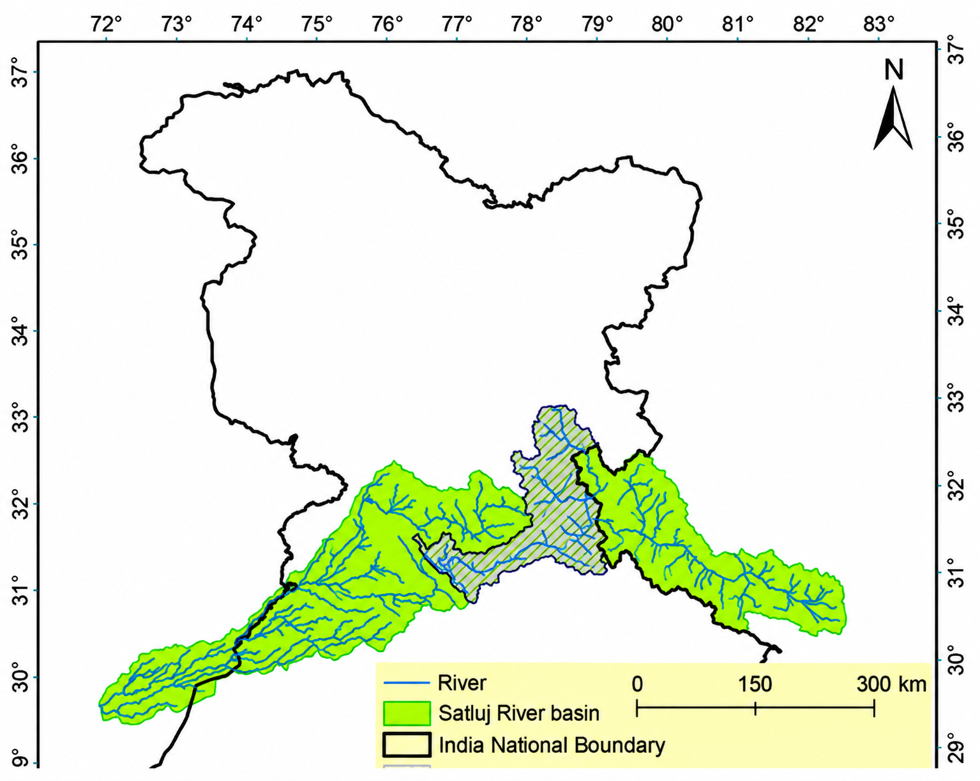


Sutlej River Course and Hydrology
The Sutlej follows a long course from the Tibetan Plateau through Himalayan gorges and Punjab’s plains, with its flow shaped by snowmelt, tributaries and water infrastructure.
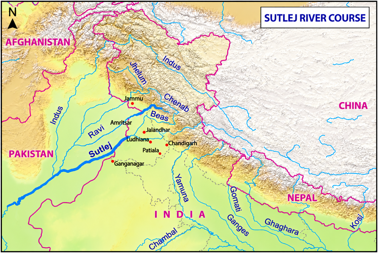
Course of the river
- Upper course: The river travels westward across Tibet before entering India through the Shipki La region. In Himachal Pradesh, it cuts through steep mountain terrain, creating deep gorges and narrow valleys.
- Middle course: The Sutlej passes through Kinnaur and the adjoining Himalayan districts, receiving water from tributaries such as the Spiti and Baspa. This stretch has a steep gradient and is extensively used for hydropower generation.
- Lower course: The river emerges into the Punjab plains near Ropar and continues towards Harike, where the Beas joins it. It then crosses into Pakistan and meets the Chenab, contributing to the Panjnad river system, whose waters ultimately flow into the Indus.
Hydrological characteristics
- The Sutlej is a snow- and glacier-fed river whose discharge varies seasonally. Snowmelt, rainfall and tributary inflows contribute to its flow, while dams and canal diversions influence the volume and timing of water downstream.
- The river is approximately 1,450–1,550 kilometres long, depending on the source and measurement method. Its mountain reaches have strong erosive power, while its lower course carries water across flatter alluvial plains.
- The river’s hydrology is especially important for irrigation, electricity generation and flood management in the Indus basin.
Sutlej River Major Tributaries
The Sutlej receives water from tributaries draining the Trans-Himalayan plateau and surrounding mountain ranges, increasing its discharge and connecting several high-altitude watersheds. Important tributaries and associated streams include:
- Spiti River: One of the most important tributaries, it drains the cold, arid Spiti Valley of Himachal Pradesh before joining the Sutlej near Khab.
- Baspa River: Originating in the Himalayan region, the Baspa flows through the Baspa Valley and joins the Sutlej near Karcham in Kinnaur district.
- Beas River: A major tributary of the Sutlej, the Beas joins it at Harike in Punjab. This confluence is important for downstream water management and irrigation.
- Nogli Khad: A stream in Himachal Pradesh that joins the Sutlej near the Rampur area.
- Soan River: A tributary in the lower Sutlej basin, associated with the foothill region near Anandpur Sahib.
- Gambhar River: A stream in the lower Himalayan basin that contributes to the Sutlej’s drainage network.
Sutlej River Major Dams and Hydropower Projects
The Sutlej’s steep Himalayan gradient provides substantial hydropower potential, while dams and associated infrastructure regulate water supplies and support irrigation across northern India.
- Bhakra Dam: Bhakra Dam is one of India’s major multipurpose river projects, constructed across the Sutlej near the Himachal Pradesh–Punjab region. It creates the Gobind Sagar Reservoir and supports hydroelectricity generation, irrigation and water storage.
- Nathpa Jhakri project: The Nathpa Jhakri project harnesses the Sutlej’s high flow and steep gradient in Himachal Pradesh. It is a major hydropower installation that contributes to electricity generation in the region.
- Karcham Wangtoo Hydroelectric Project: Located on the Sutlej in Kinnaur district, this project uses the river’s mountain flow for electricity generation. It is part of the broader hydropower development corridor in the upper basin.
- Baspa Hydroelectric Project: The Baspa II project is located on the Baspa River, a tributary of the Sutlej. It demonstrates how tributary flows also contribute to hydropower development across the basin.
Sutlej River Major Lakes
Lakes and reservoirs in the Sutlej basin are important for understanding its source geography, water storage, hydropower development and the ecology of surrounding landscapes.
- Lake Rakshastal: A high-altitude lake in Tibet near Mount Kailash and Lake Manasarovar. It lies close to the Sutlej’s source region and is a key geographical landmark associated with the river’s origin.
- Lake Manasarovar: Situated near Rakshastal, this lake is important for the religious and geographical context of the Tibetan Plateau. It is close to the Sutlej’s headwater region, although it should not be described as the river’s direct source.
- Ropar Wetland: Located in Punjab, this wetland is associated with the Sutlej basin and provides habitat for aquatic organisms and waterbirds. It is an important site for wetland conservation.
- Harike Wetland: It sits at the exact meeting point where the Beas River joins the Sutlej River.
Sutlej River Importance
The Sutlej is essential for irrigation, hydropower generation, regional water security and livelihoods, while its historical role and transboundary course make it geographically significant.
- Agricultural importance: The river supplies water to irrigation networks in Punjab and adjoining regions. Canals and reservoirs help distribute water for crops, supporting agricultural production and rural livelihoods.
- Hydropower generation: The steep gradients of the upper Sutlej provide favourable conditions for electricity generation.
- Projects such as Nathpa Jhakri, Karcham Wangtoo and Bhakra harness the river’s flow to contribute to regional power supplies.
- Drinking water and regional water security: Reservoirs and water-distribution infrastructure help manage supplies for different uses. Effective planning is important because water demand, seasonal variation and competing requirements place pressure on available resources.
- Historical and cultural importance: The Sutlej has been associated with ancient names such as Shatadru and Shutudri. Its valleys and surrounding landscapes have also shaped settlement patterns, travel routes and the cultural history of the Punjab region.
- Importance for the Indus River system: The Sutlej is one of the five major rivers historically associated with Punjab and a significant tributary of the Indus system. It joins the Beas in India and later combines with the Chenab system in Pakistan.
- Strategic and transboundary significance: As one of the Eastern Rivers under the Indus Waters Treaty of 1960, the Sutlej is important for water-resource planning and India-Pakistan relations.
- Its management has implications for irrigation, hydropower and downstream water availability.
Sutlej River Major Challenges
The Sutlej basin faces interconnected challenges arising from climate change, hydropower development, competing water demands, pollution and transboundary water management.
- Climate Change and Glacier Retreat: Rising temperatures are accelerating glacier loss and altering snowfall and snowmelt patterns. These changes may initially increase flows during certain periods but can reduce long-term meltwater reliability and increase uncertainty in seasonal river discharge.
- Floods and Glacial Lake Outburst Floods (GLOFs): Intense rainfall, rapid snowmelt and potential glacial lake outbursts can trigger floods, landslides and erosion, threatening settlements, roads, bridges and hydropower infrastructure.
- Hydropower Development: Dams and hydropower projects can alter natural flow regimes, sediment transport and aquatic habitats. Construction in steep mountain terrain may also increase slope instability and environmental degradation.
- Water Diversion and Competing Demands: Irrigation, hydropower generation, environmental flows and downstream requirements create competing demands. Changing seasonal flows and rising water demand further complicate water allocation and reservoir management.
- Pollution and Ecosystem Degradation: Urban wastewater, industrial discharges, agricultural runoff and construction-related activities can degrade water quality. Dams, water withdrawals and disrupted river connectivity may threaten aquatic biodiversity and wetlands.
- Sedimentation and Riverbank Erosion: Soil erosion, sediment transport and poorly managed construction can affect reservoir capacity, river channels and infrastructure, increasing maintenance requirements and environmental risks.
- Agricultural Vulnerability: Changes in river discharge, irregular precipitation and water shortages can disrupt irrigation, crop planning and agricultural productivity, particularly in areas dependent on seasonal flows and canal supplies.
- Transboundary Water Management: As the Sutlej flows through China, India and Pakistan, effective management requires reliable hydrological information, coordination and adherence to applicable agreements. Climate variability and competing water demands make cooperation increasingly important.
Sutlej River Way Forward
Sustainable management of the Sutlej requires coordinated water planning, responsible hydropower development, pollution prevention, climate adaptation and conservation of its mountain catchments.
- Improve water-use efficiency: Modern irrigation methods, better canal maintenance and reduced distribution losses can help improve water productivity. Planning should balance agricultural demand with drinking-water requirements and ecological needs.
- Strengthen environmental assessments: Hydropower projects should be assessed for their cumulative impacts on river flow, sediment movement, aquatic habitats, slope stability and nearby communities. Monitoring should continue throughout construction and operation.
- Improve flood forecasting and preparedness: Hydrological monitoring, weather forecasting and early-warning systems can help reduce flood damage. Authorities should prepare evacuation plans, identify vulnerable locations and strengthen the resilience of critical infrastructure.
- Monitor glaciers and glacial lakes: Satellite observations, field surveys and regular assessments of glacial lakes can improve understanding of changing risks. Warning systems should be linked to local disaster-preparedness plans.
- Control pollution: Wastewater treatment, industrial compliance and improved agricultural practices can reduce pollutants entering the river. Regular water-quality monitoring should cover tributaries as well as the main channel.
- Conserve forests and wetlands: Catchment restoration, slope stabilisation and wetland conservation can improve ecological resilience and reduce erosion. Protecting these areas also helps maintain habitats and natural water-regulation functions.
- Integrate climate change into water planning: Reservoir operations, irrigation planning and infrastructure design should account for changing rainfall, snowmelt and extreme-weather risks. Periodic reassessment can help authorities adapt as new scientific evidence becomes available.
- Strengthen community participation: Local communities should be involved in decisions about infrastructure, water allocation and conservation. Transparent consultation and accessible grievance mechanisms can help address the social impacts of river development.
Sutlej River UPSC PYQs
Q1. Identify the river of the Indian sub-continent on the basis of the following information: (UPSC Prelims 2026)
- It has an antecedent drainage system.
- It flows through three countries.
- It originates in the Tibetan Plateau and is an important river for irrigation.
- It does not form distributaries.
Select the answer from the following:
(a) Brahmaputra
(b) Indus
(c) Sutlej
(d) Teesta
Ans: (c)
Q2. With reference to the Indus River system, of the following four rivers, three of them pour into one of them which joins the Indus direct. Among the following, which one is such river that joins the Indus directly? (UPSC Prelims 2021)
(a) Chenab
(b) Jhelum
(c) Ravi
(d) Sutlej
Ans: (d)

 Last updated on Oct, 2026
→ UPSC 2027 Notification will be released on 13 January 2027 at upsconline.nic.in.
→ Check Nobel Prize 2026 Winners List here.
→ Download PIB PRiSM Monthly Magazine 2026 here.
→ Check UPSC Monthly Current Affairs Magazine The Recitals here.
→ Check out the latest UPSC Syllabus here.
→ Download UPSC Model Answers for Mains 2026
→ UPSC Mains Question Paper 2026 is out now for Essay & GS Paper 1, 2, 3 & 4.
→ UPSC Calendar 2027 has been released.
→ Enroll in Vajiram & Ravi’s UPSC Mains Test Series 2027 for structured answer writing practice, expert evaluation, and exam-oriented feedback.
→ Join Vajiram & Ravi’s UPSC Mentorship Program 2027 for personalized guidance, strategy planning, and one-to-one support from experienced mentors.
→ Go through the UPSC Mains Previous Year Papers to enhance your preparation.
→ UPSC has released UPSC Toppers List 2025 with the Civil Services final result on its official website.
→ Also check Best UPSC Coaching in India
Sutlej River FAQs
Q1. Where does the Sutlej River originate?+
Q2. What are the other names of the Sutlej River?+
Q3. Where does the Sutlej River meet the Indus River system?+
Q4. What is the significance of Bhakra Dam on the Sutlej River?+
Q5. What is the approximate length of the Sutlej River?+
Tags: quest sutlej river UPSC Geography Notes