Great Dividing Range, Location, Peaks, Biodiversity, Conservation

Great Dividing Range

The Great Dividing Range is the principal watershed of eastern Australia and one of the world’s longest mountain chains extending over 3,500 kilometres. It runs parallel to the eastern coast through Queensland, New South Wales and Victoria and it consists of plateaus, hills and low mountains. It separates river systems flowing eastward to the Pacific Ocean from those draining inland, making it a defining physiographic and hydrological feature of the continent.

Great Dividing Range Features

The Great Dividing Range forms a vast and complex upland system with varied elevations, geology and hydrology across eastern Australia. The major features include:

  • Extent and Location: The range stretches about 3,500 to 3,700 km from Cape York Peninsula in Queensland to the Grampians in Victoria, with widths ranging from 160 to 300 km along the eastern coastline.
  • Physiography: It is not a single continuous range but a cordillera system comprising plateaus, escarpments, rolling hills and low mountain ranges formed through folding, faulting and long term erosion processes.
  • Elevation Pattern: Average elevations range from 600 to 900 metres in Queensland to around 900 metres further south, while peaks exceed 2,000 metres in the Australian Alps region.
  • Highest Peak: Mount Kosciuszko at 2,228 metres in the Snowy Mountains represents the highest point of the entire range and of mainland Australia.
  • Major Subregions: Important sections include the Australian Alps, Blue Mountains, McPherson Range and Lamington Plateau, each with distinct topography and climatic conditions.
  • Geological Composition: Rocks include sandstone, limestone, dolomite, quartzite and schist, reflecting a complex geological history involving tectonic uplift and erosion over millions of years.
  • Watershed: The range forms the main drainage divide, with eastern rivers flowing into the Pacific Ocean and western rivers joining inland systems like the Murray-Darling Basin.
  • River Systems: Major rivers originating here include Snowy, Murrumbidgee, Lachlan, Darling and Goulburn on the west and Burdekin, Hunter and Clarence flowing eastward.
  • Water Resource Role: It supplies water to over 10 million people and feeds major irrigation and hydroelectric projects such as the Snowy Mountains Scheme and Upper Nepean Scheme.
  • Landforms: The region includes tablelands like Atherton Tableland, valleys, canyons, waterfalls and fertile plains such as Darling Downs and Southern Highlands supporting agriculture.

Great Dividing Range Biodiversity

The Great Dividing Range supports diverse ecosystems ranging from tropical rainforests to alpine environments with rich flora and fauna.

  • Vegetation Diversity: The range includes tropical rainforests in Queensland, eucalypt forests in central regions and alpine grasslands in the south, reflecting climatic and altitudinal variation.
  • Faunal Diversity: The region hosts marsupials such as kangaroos, wallabies and koalas, along with birds like lyrebirds and reptiles adapted to varied climatic zones.
  • Ecological Corridors: The range acts as a biological corridor enabling species migration between northern tropical and southern temperate ecosystems.
  • Endemism: Many species are endemic due to geographical isolation and varied habitats, particularly in rainforest and alpine zones.
  • Fire Adaptation: Vegetation such as eucalyptus forests is adapted to periodic bushfires, playing a key role in ecological regeneration.
  • Biodiversity Hotspots: Areas like the Greater Blue Mountains and Lamington Plateau are recognized for high species richness and conservation value.

Great Dividing Range Significance

The Great Dividing Range plays a critical role in Australia’s economy, environment, culture and infrastructure systems.

  • Agriculture: Fertile regions like Darling Downs and tablelands support grazing, mixed farming and fruit cultivation, making the range vital for agricultural productivity.
  • Water Supply: It is the primary source of freshwater for eastern Australia, supporting irrigation, urban water supply and major river systems like the Murray-Darling Basin.
  • Hydroelectric Projects: Rivers originating from the range power hydroelectric schemes such as the Snowy Mountains project, contributing significantly to energy generation.
  • Mining Resources: The region supports mining of minerals and coal, contributing to regional economies and industrial development across New South Wales and Queensland.
  • Tourism: National parks like Blue Mountains National Park attract tourists for scenic landscapes, waterfalls and recreational activities.

Great Dividing Range Conservation

Conservation efforts focus on protecting ecosystems, biodiversity and water resources through protected areas and environmental management.

  • National Parks Network: Over 90 protected areas exist, including Kosciuszko National Park and Alpine National Park, safeguarding large sections of the range.
  • World Heritage Areas: Sites such as Greater Blue Mountains and Gondwana Rainforests are recognized globally for ecological and evolutionary significance.
  • Water Resource Management: Policies regulate river systems and groundwater recharge, particularly for the Great Artesian Basin and major irrigation schemes.
  • Indigenous Participation: Indigenous communities are increasingly involved in land management and conservation using traditional ecological knowledge.
  • Tourism Management: Sustainable tourism practices are promoted in national parks to minimize ecological damage while supporting local economies. 

Great Dividing Range FAQs

Q1: Where is the Great Dividing Range located?

Ans: The Great Dividing Range is located in eastern Australia, extending across Queensland, New South Wales and Victoria parallel to the eastern coastline.

Q2: What is the length of the Great Dividing Range?

Ans: The range extends for more than 3,500 kilometres, making it the longest mountain range located entirely within a single country.

Q3: Which is the highest peak in the Great Dividing Range?

Ans: Mount Kosciuszko, with an elevation of 2,228 metres, is the highest peak in the Great Dividing Range.

Q4: Why is the Great Dividing Range important for Australia?

Ans: It acts as Australia’s main watershed, supports major rivers, provides water resources and plays a key role in agriculture, climate and biodiversity.

Q5: Which rivers originate from the Great Dividing Range?

Ans: Major rivers include the Snowy, Murrumbidgee, Lachlan, Darling and Goulburn, along with several east flowing rivers draining into the Pacific Ocean.

Nilgiri Hills, Location, Climate, Peaks, Flora, Fauna

Nilgiri Hills

The Nilgiri Hills are located in southern India at the junction of Tamil Nadu, Kerala, and Karnataka, forming part of the Western Ghats. The detailed article on Nilgiri Hills has been discussed below in this article.

About Nilgiri Hills

The Nilgiri Hills are a beautiful mountain range located in southern India, forming part of the Western Ghats. Known for their cool climate, lush greenery, and tea plantations, they are one of the most popular hill regions in the country. These hills are also an important biodiversity hotspot with rich flora, fauna, and tribal culture.

  • The Nilgiri Hills are situated at the junction of Tamil Nadu, Kerala, and Karnataka.
  • They are an integral part of the Western Ghats, a UNESCO World Heritage Site.
  • The name “Nilgiri” means “Blue Mountains,” derived from the seasonal bloom of the Neelakurinji flower.
  • The highest peak is Doddabetta Peak, with an elevation of about 2,637 meters.
  • Famous hill stations like Ooty, Coonoor, and Kotagiri are located here.
  • The region includes the Nilgiri Biosphere Reserve, known for its ecological importance.
  • It features unique shola forests and grassland ecosystems.
  • Major rivers such as the Bhavani River and Kabini River originate from these hills.
  • The hills are rich in wildlife, including elephants, tigers, and endemic species like the Nilgiri tahr.
  • Indigenous tribes like Todas, Kotas, and Kurumbas inhabit the region with distinct cultural traditions.

Flora of Nilgiri Hills

  • The Nilgiris are famous for their unique shola forest-grassland ecosystem, where dense evergreen forests (sholas) are found in valleys surrounded by rolling grasslands.
  • These forests are rich in evergreen tree species such as Michelia, Rhododendron, and Syzygium, which thrive in cool and moist conditions.
  • Extensive tea plantations dominate the landscape, especially around Ooty and Coonoor, contributing to the region’s economy.
  • Other plantation crops include coffee, eucalyptus, cinchona, and wattle, introduced during the colonial period.
  • The hills contain a wide variety of medicinal plants used in traditional healing practices by local tribes.
  • Grasslands in higher altitudes consist of hardy grasses that support grazing animals and prevent soil erosion.
  • The forests include valuable timber species like teak, rosewood, and sandalwood in lower elevations.

Fauna of Nilgiri Hills

  • The Nilgiri Hills are home to the famous Nilgiri tahr, an endangered species found only in the Western Ghats.
  • Large mammals such as the Asian elephant, Bengal tiger, Indian leopard, and gaur (Indian bison) are commonly found.
  • The region forms part of an important elephant corridor, allowing seasonal migration between forests of Tamil Nadu, Kerala, and Karnataka.
  • Rich biodiversity is protected within reserves like Mudumalai National Park and Bandipur National Park.
  • Smaller mammals include sambar deer, spotted deer, wild boar, Indian giant squirrel, and civets.
  • The Nilgiri Hills are also home to primates like the Lion-tailed macaque, which is an endangered and endemic species.
  • The region supports a rich variety of birds, including hornbills, eagles, Nilgiri flycatcher, and Malabar trogon, making it a paradise for birdwatchers.
  • Reptiles such as king cobras, pythons, and various lizard species are found in the forests.

Nilgiri Hills FAQs

Q1: Where are the Nilgiri Hills located?

Ans: The Nilgiri Hills are located in southern India at the tri-junction of Tamil Nadu, Kerala, and Karnataka, forming part of the Western Ghats.

Q2: Why are the Nilgiri Hills called Blue Mountains?

Ans: They are called Blue Mountains due to the bluish appearance of the hills, especially during the blooming of the Neelakurinji flowers.

Q3: Which is the highest peak in the Nilgiri Hills?

Ans: The highest peak in the Nilgiri Hills is Doddabetta Peak, with an elevation of about 2,637 meters.

Q4: What is the Nilgiri Biosphere Reserve?

Ans: It is India’s first biosphere reserve, known for its rich biodiversity and conservation efforts.

Q5: What wildlife can be found in Nilgiri Hills?

Ans: The region is home to elephants, tigers, leopards, Nilgiri tahr, and many bird species.

Biligiriranga Hills, Tiger Reserve, Biodiversity, Conservation

Biligiriranga Hills

Biligiriranga Hills is also known as Biligirirangan Hills. They form a unique hill range in south-western Karnataka along the Tamil Nadu border. These hills lie in Chamarajanagar district and are protected under the Wildlife Protection Act 1972. The region acts as a crucial ecological link between the Western Ghats and Eastern Ghats, supporting rich biodiversity, varied climate and significant wildlife movement across southern India.

Biligiriranga Hills Features

Biligiriranga Hills represent a geographically and ecologically significant hill system acting as a natural bridge between two major mountain ranges of India. The significant features of the hills include:

  • Location: The hills are located in Chamarajanagar district of Karnataka, bordering Erode district of Tamil Nadu. 
  • Extent: The sanctuary spans about 540 sq km, stretching nearly 35 km north-south and 15 km east-west across varied terrain.
  • Significance: The hills form a vital ecological bridge between the Western Ghats and Eastern Ghats, enabling gene flow and species movement. This connectivity supports biodiversity across the Deccan Plateau and strengthens wildlife corridors.
  • Elevation: The elevation ranges from about 600 m at the base to 1,800 m at the highest peak. The hills rise prominently above surrounding plains like Mysore and Bangalore plateau.
  • Peaks: The highest peak of the hill range is Kattari Betta.
  • Geology: The hills are composed mainly of charnockite rocks and form a north-south ridge system. They represent a northeastern extension of the Western Ghats merging with fragmented Eastern Ghats.
  • Climate and Rainfall: The region experiences varied climate with temperatures ranging from 9°C to 38°C. Rainfall varies from 600 mm at lower elevations to nearly 3000 mm at higher altitudes.
  • Cultural Significance: The name “Biligiri” refers to white rocky cliffs or mist covered hills. The region houses the Ranganathaswamy temple dedicated to Lord Vishnu, attracting pilgrims annually.
  • Ecological Significance: The hills form a vital ecological bridge between the Western Ghats and Eastern Ghats, enabling gene flow and species movement. This connectivity supports biodiversity across the Deccan Plateau and strengthens wildlife corridors

Biligiriranga Hills Biodiversity

The Biligiriranga Hills exhibit exceptional biodiversity due to varied habitats and their location between two major ecological regions of India.

  • Forest Types: The hills support diverse vegetation including scrub forests, deciduous forests, riparian zones, evergreen forests, sholas and montane grasslands due to altitude and climatic variations.
  • Floral Diversity: The forests contain nearly 800 plant species belonging to different families. Vegetation ranges from southern tropical evergreen and semi evergreen to moist deciduous forests, reflecting strong Western Ghats affinity.
  • Mammalian Fauna: Around 26 mammal species are recorded, including major ungulates such as gaur, sambar, spotted deer, barking deer and rare four horned antelope, indicating healthy herbivore populations.
  • Carnivores: Key predators include tiger, leopard, wild dog, lesser cats and civet cats. The tiger density is about 9 per 100 sq km, showing strong conservation value of the habitat.
  • Elephant Population: The hills support large herds of Asian elephants and act as one of the few habitats east of the Western Ghats where these animals occur in significant numbers.
  • Arboreal Species: The forests host arboreal mammals including two primate species and three squirrel species, notably the giant flying squirrel, indicating well developed canopy ecosystems.
  • Avifauna Diversity: More than 250 bird species have been recorded, making the region an important bird habitat. It includes rare species such as the white winged tit.
  • Endangered Species: Species like Icthyophis ghytinosus, an endangered caecilian and Microhyla sholigari highlight the region’s endemic and lesser known biodiversity richness.

Biligiriranga Hills Conservation

Various measures for the conservation and protection of the diverse flora and fauna of the Biligiriranga Hills has been adopted as highlighted below:

  • Sanctuary and Legal Status: The wildlife sanctuary was established in 1974 with 322.4 sq km area and expanded to 539.52 sq km in 1987.
  • BRT Tiger Reserve: The area was declared Biligiri Rangaswamy Temple Tiger Reserve in January 2011, with a notable tiger density of 9 per 100 sq km, making it an important conservation landscape for large carnivores in southern India.
  • Connectivity and Corridors: Major wildlife corridors include Edayarhalli-Doddasampige and Chamarajanagar-Talamalai routes. Elephant corridors like Punjur-Sathyamangalam enhance large mammal movement across landscapes.
  • Conservation Challenges: Threats include quarrying activities and illegal resorts within the reserve. The National Tiger Conservation Authority has directed action against such encroachments to protect the ecosystem. 

Biligiriranga Hills FAQs

Q1: Where are Biligiriranga Hills located?

Ans: Biligiriranga Hills are located in the Chamarajanagar district of Karnataka, along the border with Tamil Nadu’s Erode district in South India.

Q2: Why are Biligiriranga Hills ecologically important?

Ans: They act as a natural bridge between the Western Ghats and Eastern Ghats, enabling wildlife movement and gene flow across species in the Deccan Plateau.

Q3: When was BRT Tiger Reserve declared?

Ans: Biligiri Rangaswamy Temple Tiger Reserve was declared a tiger reserve in January 2011 by the Government of Karnataka.

Q4: What is the highest peak in Biligiriranga Hills?

Ans: The highest peak in the range is Kattari Betta, which rises to about 1,800 metres above sea level.

Q5: What kind of wildlife is found in Biligiriranga Hills?

Ans: The hills support diverse wildlife including tigers, elephants, leopards, gaur, deer species, over 250 bird species and rare amphibians like Icthyophis ghytinosus.

Major Mountain Ranges of the World, Type, Peak, Flora, Fauna

Major Mountain Ranges of the World

Mountain ranges are large groups of mountains that are connected by land. They are formed over millions of years due to movements in the Earth’s crust, volcanic activity, and erosion. These ranges play a crucial role in shaping climate, biodiversity, rivers, and human civilization. From the towering peaks of the Himalayas to the ancient hills of the Appalachian Mountains, mountain ranges are found on every continent. In this article, we have discussed all the Major Mountain Ranges of the World.

Formation of Mountain Ranges

Mountain ranges are formed over millions of years due to movements inside the Earth, especially the shifting of tectonic plates. These movements cause the land to rise, fold, or break, creating mountains. Different geological processes result in different types of mountain ranges across the world, such as the Himalayas and the Andes.

  • Tectonic Plate Movement: Mountain ranges mainly form when Earth’s plates collide, move apart, or slide past each other, creating pressure and uplift.
  • Fold Mountains Formation: When two plates collide, the crust folds and rises to form mountains like the Himalayas.
  • Faulting (Block Mountains): Cracks in the Earth’s crust cause some land blocks to rise and others to sink, forming ranges like the Sierra Nevada.
  • Volcanic Activity: Repeated volcanic eruptions build up mountains over time, seen in ranges like the Andes.
  • Erosion and Weathering: Wind, water, and ice gradually shape and modify mountains, forming residual ranges like the Aravalli Range.
  • Uplift and Subsidence: Parts of the Earth’s crust rise or sink due to internal forces, contributing to mountain formation.

Major Mountain Ranges of Asia

Asia is home to some of the highest and most extensive mountain ranges in the world. These ranges were mainly formed due to the collision of tectonic plates, especially the Indian and Eurasian plates. They play an important role in climate, rivers, biodiversity, and human life across the continent.

1. Himalayas

  • Type: Young Fold Mountains formed due to collision of Indian and Eurasian plates (still rising)
  • Length & Location: Extend about 2,400 km across India, Nepal, Bhutan, China, and Pakistan
  • Major Peaks: Mount Everest, Kanchenjunga, Nanda Devi, Annapurna, Dhaulagiri
  • Physiographic Divisions: Himadri (Greater Himalaya), Himachal (Lesser Himalaya), Shiwalik (Outer Himalaya)
  • Climate Role: Act as a barrier preventing cold Central Asian winds and help in monsoon rainfall in India
  • River Systems: Source of major perennial rivers like Ganga, Yamuna, Brahmaputra, and Indus
  • Glaciers: Contain large glaciers such as Gangotri, Yamunotri, Siachen (nearby region), Zemu Glacier
  • Flora: Tropical forests in foothills, temperate forests (oak, pine, deodar), alpine vegetation, medicinal plants
  • Fauna: Snow leopard, red panda, Himalayan black bear, musk deer, yak, Himalayan monal
  • Agriculture: Terrace farming is common; crops include rice, wheat, barley, and fruits

2. Karakoram Range

  • Type: Fold Mountains (young and highly rugged)
  • Location: Spread across India (Ladakh), Pakistan, and China
  • Major Peaks: K2, Gasherbrum I & II, Broad Peak
  • Glaciers: Home to some of the longest glaciers outside polar regions like Siachen Glacier and Baltoro Glacier
  • Climate: Extremely cold desert climate with heavy snowfall, strong winds, and low oxygen levels
  • Terrain: Very steep, rocky, and difficult terrain with deep valleys and sharp ridges
  • Flora: Very sparse vegetation; mainly mosses, lichens, and alpine grasses due to harsh climate
  • Fauna: Snow leopard, ibex, Himalayan brown bear, lynx, wild sheep
  • Water Resources: Glaciers feed important rivers like the Indus River
  • Human Settlement: Very low population due to extreme conditions; limited habitation
  • Strategic Importance: Highly sensitive border region (India-Pakistan-China), important for defense

3. Hindu Kush

  • Type: Fold Mountains
  • Location: Extend across Afghanistan and north-western Pakistan
  • Major Peaks: Tirich Mir (highest peak), Noshaq
  • Length: About 800 km long mountain range
  • Climate: Cold winters, dry conditions, and limited rainfall
  • Terrain: Rugged mountains with deep valleys and narrow passes
  • Flora: Dry forests, shrubs, juniper trees, and alpine grasses
  • Fauna: Snow leopard, markhor, wolves, foxes, mountain goats
  • Passes: Famous passes like Khyber Pass and Salang Pass (historically important)
  • Historical Importance: Served as a major route for trade, migration, and invasions between Central and South Asia

4. Tian Shan

  • Type: Fold Mountains
  • Location: Spread across China, Kyrgyzstan, Kazakhstan, and Uzbekistan
  • Length: Around 2,500 km long mountain system
  • Major Peaks: Jengish Chokusu (Victory Peak), Khan Tengri
  • Meaning: Known as “Heavenly Mountains” due to great height and scenic beauty
  • Climate: Cold continental climate with heavy snowfall and glaciers
  • Terrain: High rugged peaks, deep valleys, and extensive glaciated areas
  • Flora: Coniferous forests (spruce), alpine meadows, grasslands, and wild fruit trees (origin of apples)
  • Fauna: Snow leopard, ibex, lynx, wild sheep (argali), bears
  • Water Resources: Source of major rivers like Syr Darya; glaciers provide water to dry regions
  • Economic Importance: Supports agriculture through irrigation, pastoral activities, and mining

5. Altai Mountains

  • Type: Fold Mountains
  • Location: Spread across Russia, Mongolia, China, and Kazakhstan
  • Major Peaks: Belukha Mountain (highest peak)
  • Climate: Cold temperate climate with heavy snowfall and long winters
  • Terrain: Mountainous region with glaciers, rivers, valleys, and forested slopes
  • Flora: Dense forests of pine, fir, spruce, and birch; alpine grasslands and meadows
  • Fauna: Brown bear, snow leopard, elk, sable, lynx, wild sheep
  • Water Resources: Important watershed for rivers like Irtysh, Ob, and Yenisei
  • Biodiversity: Recognized as a biodiversity hotspot with many rare and endemic species
  • Cultural Importance: Home to nomadic tribes and ancient cultures; rich archaeological sites
  • Economic Importance: Rich in minerals such as gold, copper, and zinc
  • Human Activities: Animal grazing, forestry, mining, and traditional livelihoods
  • UNESCO Status: Parts of Altai region are UNESCO World Heritage Sites

6. Zagros Mountains

  • Type: Fold Mountains
  • Location: Mainly in Iran, extending into Iraq
  • Length: About 1,500 km long
  • Major Peaks: Zard Kuh, Dena
  • Formation: Formed due to collision of Arabian and Eurasian plates
  • Climate: Semi-arid to Mediterranean type climate
  • Terrain: Rugged mountains with folded structures and fertile valleys
  • Flora: Oak forests, pistachio trees, shrubs, grasslands
  • Fauna: Persian leopard, wild goat, hyena, fox, wolves
  • Natural Resources: Very rich in oil and natural gas reserves
  • Agriculture: Valleys suitable for farming (wheat, barley)
  • Human Settlement: Moderately populated with tribal communities
  • Economic Importance: Oil extraction, agriculture, and grazing

7. Ural Mountains

  • Type: Very Old Fold Mountains (highly eroded)
  • Location: Russia, extending from Arctic Ocean to Kazakhstan
  • Length: Around 2,500 km
  • Major Peaks: Mount Narodnaya
  • Significance: Natural boundary between Europe and Asia
  • Climate: Varies from tundra (north) to temperate (south)
  • Terrain: Low to moderate height due to long-term erosion
  • Flora: Taiga forests (pine, spruce, fir), tundra vegetation in north
  • Fauna: Reindeer, brown bear, wolf, arctic fox, lynx
  • Natural Resources: Rich in iron ore, coal, gold, platinum, and other minerals
  • Industrial Importance: Major mining and industrial region of Russia
  • Water Resources: Source of several rivers flowing to Europe and Asia
  • Human Settlement: Well-developed settlements and industrial cities

8. Aravalli Ranges

  • Type: Residual (Old Fold Mountains, highly eroded)
  • Location: Extends from Gujarat to Delhi in India
  • Length: Around 700-800 km
  • Major Peaks: Guru Shikhar (highest peak in Mount Abu)
  • Age: One of the oldest mountain ranges in the world
  • Climate Influence: Acts as a barrier influencing desert expansion and local climate
  • Terrain: Low hills, rocky ridges, and worn-down mountains
  • Flora: Dry deciduous forests, thorny bushes, grasses
  • Fauna: Leopard, hyena, jackal, nilgai, various birds
  • Natural Resources: Rich in minerals like copper, zinc, marble, and granite
  • Environmental Role: Helps prevent desertification of nearby regions like Rajasthan
  • Human Activities: Mining, agriculture, and urban development

Major Mountain Ranges of Europe

The major mountain ranges of Europe include the Alps, Pyrenees, Carpathian Mountains, and Scandinavian Mountains. These ranges vary in age and height and play an important role in shaping Europe’s climate, rivers, and biodiversity.

1. Alps

  • Type: Young Fold Mountains (formed during the Alpine orogeny due to collision of African and Eurasian plates)
  • Location: Stretch across 8 countries: France, Switzerland, Italy, Austria, Germany, Slovenia, Liechtenstein, and Monaco
  • Major Peaks: Mont Blanc, Matterhorn, Dufourspitze, Jungfrau
  • Highest Peak: Mont Blanc (approx. 4,808 m) located on the France-Italy border

Physical Features:

  • Consist of high rugged peaks, deep valleys, and extensive glaciated regions
  • Presence of famous glaciers like Aletsch Glacier (largest in the Alps)
  • Divided into Western Alps and Eastern Alps based on geography
  • Numerous passes like Brenner Pass and St. Gotthard Pass for transportation

Climate:

  • Alpine climate with long, cold winters and short, cool summers
  • Heavy snowfall in higher altitudes supports glaciers and winter sports
  • Strong influence on Europe’s weather patterns

Flora:

  • Lower slopes: Deciduous forests (oak, beech)
  • Middle slopes: Coniferous forests (pine, fir, spruce)
  • Higher regions: Alpine meadows with grasses and flowers
  • Snow line: Almost no vegetation

Fauna:

  • Mountain animals like ibex, chamois, marmots
  • Predators such as brown bear and lynx (in limited areas)
  • Rich birdlife including golden eagle

Rivers & Water Resources:

  • Source of major European rivers like Rhine, Rhone, Danube, and Po
  • Glaciers act as freshwater reservoirs for Europe
  • Important for hydroelectric power generation

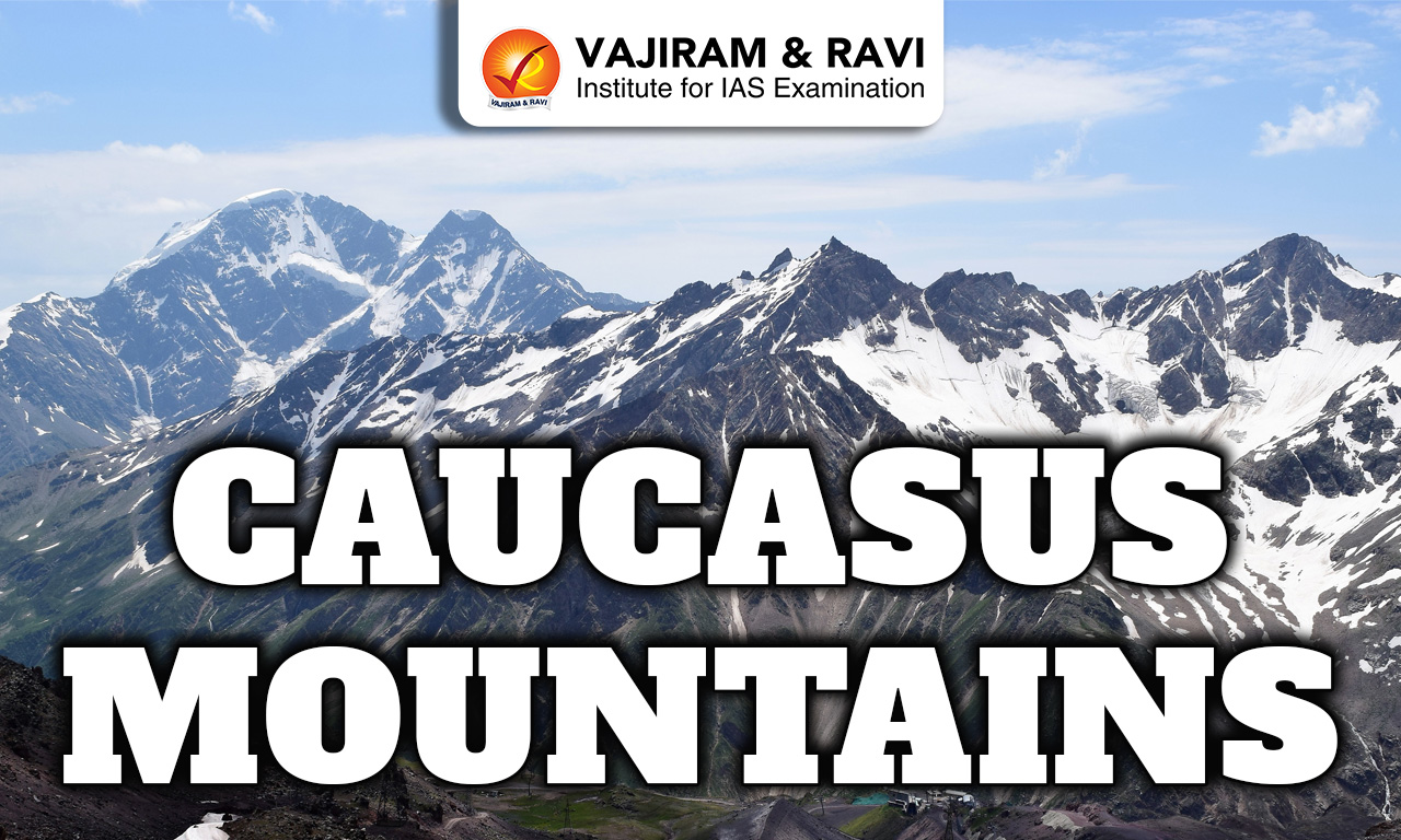
2. Caucasus Mountains

  • Type: Fold Mountains
  • Location: Between the Black Sea and Caspian Sea
  • Countries Covered: Russia, Georgia, Armenia, Azerbaijan
  • Major Peaks: Mount Elbrus, Mount Kazbek
  • Climate: Varies from humid to alpine conditions
  • Terrain: High mountainous region with snow-covered peaks and deep valleys
  • Flora: Mixed forests, coniferous forests, alpine meadows
  • Fauna: Caucasian leopard, brown bear, mountain goats, lynx
  • Biodiversity: One of the world’s biodiversity hotspots with many endemic species
  • Cultural Diversity: Home to many ethnic groups, languages, and traditions
  • Economic Importance: Tourism, agriculture in valleys, and hydroelectric power

3. Scandinavian Mountains

  • Type: Old Fold Mountains (highly eroded)
  • Location: Norway and Sweden
  • Major Peaks: Glittertind
  • Physical Features: Rounded peaks, fjords, glacial valleys
  • Climate: Cold climate with heavy snowfall and tundra in north
  • Flora & Fauna: Coniferous forests; reindeer, elk, arctic fox
  • Importance: Hydroelectric power, tourism, mineral resources

4. Pyrenees

  • Type: Fold Mountains formed during Alpine orogeny
  • Location: Natural boundary between Spain and France (also includes Andorra)
  • Major Peaks: Aneto (highest), Posets, Monte Perdido
  • Physical Features: Rugged terrain, steep slopes, narrow valleys, limited passes
  • Climate: Mix of Atlantic (west) and Mediterranean (east) influences
  • Flora & Fauna: Oak, beech, pine forests; animals like brown bear, ibex, eagles
  • Importance: Natural barrier, tourism (trekking, skiing), biodiversity conservation

5. Balkan Mountains

  • Type: Fold Mountains
  • Location: Mainly in Bulgaria, extending into Serbia
  • Major Peaks: Botev Peak (highest)
  • Physical Features: Moderate height with forested slopes and valleys
  • Climate: Temperate with cold winters and warm summers
  • Flora & Fauna: Oak, beech forests; bears, wolves, deer
  • Importance: Influences climate, supports agriculture, tourism and biodiversity

Major Mountain Ranges of North America

North America has several important mountain ranges that extend across Canada, the United States, and Mexico. Most of these are fold mountains formed due to tectonic plate movements, while some are older and eroded. These ranges play a key role in climate, rivers, natural resources, and biodiversity.

1. Rocky Mountains

  • Type & Formation: Fold Mountains formed during the Laramide orogeny due to compression of tectonic plates
  • Location & Extent: Stretch from British Columbia (Canada) to New Mexico (USA), forming the western backbone of North America
  • Major Peaks: Mount Elbert, Mount Robson, Pikes Peak
  • Sub-Ranges: Includes Front Range, Wasatch Range, Bitterroot Range, and Canadian Rockies
  • Physical Features: Sharp peaks, high plateaus, intermontane basins, deep river valleys
  • Continental Divide: Forms a major watershed dividing rivers flowing to the Pacific and Atlantic Oceans
  • Climate: Varies widely, cold alpine climate in north, semi-arid in southern regions
  • Flora: Dense coniferous forests (pine, spruce, fir), alpine tundra at higher elevations
  • Fauna: Grizzly bear, elk, moose, mountain lion, bighorn sheep, wolves
  • Water Resources: Source of major rivers—Colorado, Columbia, Missouri, Rio Grande
  • Natural Resources: Rich in minerals like gold, silver, copper, and coal

2. Appalachian Mountains

  • Type & Age: Very old fold mountains formed over 300 million years ago; heavily eroded
  • Location: Extend from Newfoundland (Canada) to Alabama (USA)
  • Major Peaks: Mount Mitchell, Mount Washington
  • Sub-Ranges: Blue Ridge Mountains, Great Smoky Mountains, Allegheny Mountains
  • Physical Features: Rounded hills, broad valleys, low elevation compared to Rockies
  • Climate: Humid climate with abundant rainfall and seasonal variation
  • Flora: Rich deciduous forests (oak, maple, chestnut), mixed forests
  • Fauna: Black bear, white-tailed deer, fox, raccoon, diverse bird species
  • Natural Resources: Large reserves of coal, iron ore, natural gas
  • Economic Importance: Early center of industrial development in USA (coal mining, steel)
  • Agriculture: Suitable for farming in valleys (corn, wheat, fruits)

3. Sierra Nevada

  • Type & Formation: Block Mountains formed by faulting and uplift of Earth’s crust
  • Location: Eastern California and western Nevada (USA)
  • Major Peaks: Mount Whitney (highest in mainland USA), Mount Williamson
  • Physical Features: Steep eastern escarpment, gentle western slope, granite domes and cliffs
  • Famous Landforms: Yosemite Valley, Lake Tahoe, Sequoia groves
  • Climate: Mediterranean dry summers and wet winters with snowfall at higher altitudes
  • Flora: Giant sequoia trees, pine forests, mixed conifer forests
  • Fauna: Black bear, mule deer, mountain lion, bobcat, birds
  • Water Resources: Major source of water for California; rivers like Sacramento and San Joaquin
  • Economic Importance: Tourism, forestry, water supply, hydroelectric power

4. Cascade Range

  • Type & Formation: Volcanic Mountains formed due to subduction of the Pacific Plate beneath the North American Plate
  • Location: Extends from British Columbia (Canada) to northern California (USA)
  • Major Peaks: Mount Rainier, Mount St. Helens, Mount Hood, Mount Shasta
  • Volcanic Activity: Contains active and dormant volcanoes; Mount St. Helens erupted in 1980
  • Physical Features: Snow-covered peaks, lava plateaus, volcanic cones, deep valleys
  • Climate: Heavy rainfall on western slopes, creating dense forests; snowy winters
  • Flora: Evergreen forests (fir, cedar, hemlock), mosses, ferns
  • Fauna: Elk, black bear, cougar, deer, various bird species
  • Water Resources: Source of rivers and hydroelectric power generation
  • Economic Importance: Forestry, tourism, energy production

Major Mountain Ranges of South America

South America is dominated by one of the most impressive mountain systems in the world, along with a few smaller highland ranges. Most of these mountains are young fold mountains formed due to tectonic plate movements, especially the subduction of the Nazca Plate beneath the South American Plate.

1. Andes

  • Type: Young Fold Mountains (formed by subduction of Nazca Plate)
  • Location: Run along the western coast of South America across 7 countries: Venezuela, Colombia, Ecuador, Peru, Bolivia, Chile, Argentina
  • Length & Width: About 7,000 km long (longest continental mountain range in the world)
  • Major Peaks: Aconcagua, Ojos del Salado, Huascaran
  • Physical Features: High mountain chains, plateaus (Altiplano), deep valleys, volcanic peaks
  • Volcanic Activity: Contains many active and dormant volcanoes (part of the Pacific Ring of Fire)
  • Climate: Varies from tropical (north) to cold desert (Atacama region) and alpine climate in high altitudes
  • Flora: Tropical forests, grasslands, alpine vegetation depending on altitude
  • Fauna: Llama, alpaca, vicuna, condor, puma
  • Water Resources: Source of major rivers including Amazon tributaries
  • Natural Resources: Rich in minerals like copper, silver, gold, tin
  • Human Settlement: Dense population in valleys and plateaus (e.g., Andean civilizations)
  • Economic Importance: Mining, agriculture (terrace farming), tourism
  • Environmental Importance: Controls rainfall patterns and supports biodiversity

2. Brazilian Highlands

  • Type: Old Fold Mountains / Highlands (highly eroded plateau region)
  • Location: Eastern and central Brazil
  • Major Peaks: Pico da Bandeira
  • Physical Features: Rolling hills, plateaus, and escarpments
  • Climate: Tropical and subtropical climate
  • Flora: Tropical forests, savanna (Cerrado vegetation)
  • Fauna: Jaguar, tapir, monkeys, birds
  • Water Resources: Source of major rivers like Sao Francisco
  • Economic Importance: Agriculture (coffee, sugarcane), mining
  • Human Settlement: Densely populated region with major cities
  • Environmental Issues: Deforestation and land degradation

3. Guiana Highlands

  • Type: Old Plateau / Residual Mountains
  • Location: Northern South America (Venezuela, Guyana, Suriname, Brazil)
  • Major Peaks: Mount Roraima
  • Physical Features: Flat-topped mountains (tepuis), waterfalls, plateaus
  • Climate: Tropical climate with heavy rainfall
  • Flora: Dense tropical rainforests
  • Fauna: Jaguars, sloths, reptiles, diverse bird species
  • Famous Feature: Angel Falls (world’s highest waterfall)
  • Economic Importance: Mining (gold, bauxite), tourism

Major Mountain Ranges of Africa

Africa has several important mountain ranges and highlands, though it is not as mountainous as Asia or South America. These mountains are formed by a mix of folding, faulting, and volcanic activity. They play a key role in influencing climate, rivers, wildlife, and human settlements across the continent.

1. Atlas Mountains

  • Type: Fold Mountains (formed during Alpine orogeny)
  • Location: Stretch across Morocco, Algeria, and Tunisia
  • Length & Divisions: About 2,500 km; divided into High Atlas, Middle Atlas, and Anti-Atlas
  • Major Peaks: Mount Toubkal (highest in North Africa)
  • Physical Features: Rugged mountains, plateaus, deep valleys, and passes
  • Climate: Mediterranean climate in north; arid conditions towards Sahara Desert
  • Flora: Cedar, oak, pine forests in higher regions; shrubs in dry areas
  • Fauna: Barbary macaque, Atlas mountain goat, leopards (rare), birds
  • Water Resources: Source of rivers and seasonal streams supporting agriculture
  • Economic Importance: Farming (olives, fruits), mining (phosphates), tourism
  • Human Settlement: Berber communities living in valleys and mountains
  • Environmental Role: Acts as a barrier separating coastal climate from Sahara Desert

2. Drakensberg Mountains

  • Type: Fold Mountains with volcanic origins (basalt formations)
  • Location: South Africa and Lesotho
  • Major Peaks: Thabana Ntlenyana (highest peak in Southern Africa)
  • Physical Features: Steep escarpments, flat-topped plateaus, dramatic cliffs
  • Climate: Cooler and wetter than surrounding areas; snowfall in winter
  • Flora: Grasslands, alpine vegetation, shrubs
  • Fauna: Antelope, baboons, jackals, eagles, vultures
  • Water Resources: Source of important rivers like Orange and Tugela
  • Cultural Importance: Rock art of San (Bushmen) people found in caves
  • Economic Importance: Agriculture (grazing), tourism, water supply

3. Ethiopian Highlands

  • Type: Volcanic Highlands (formed by volcanic activity and uplift)
  • Location: Ethiopia (also extends into Eritrea)
  • Major Peaks: Ras Dashen (highest peak)
  • Physical Features: Large plateaus, deep gorges, volcanic mountains, Rift Valley edges
  • Climate: Cooler than surrounding lowlands; moderate rainfall
  • Flora: Grasslands, forests, crops like teff and barley
  • Fauna: Ethiopian wolf, gelada baboon, ibex, endemic bird species
  • Water Resources: Source of Blue Nile River (Lake Tana region)
  • Agriculture: Highly fertile volcanic soil supports farming
  • Human Settlement: Densely populated due to favorable climate and fertile land
  • Economic Importance: Agriculture, hydropower, and livestock

4. Tibesti Mountains

  • Type: Volcanic Mountains
  • Location: Northern Chad and southern Libya (Sahara Desert)
  • Major Peaks: Emi Koussi (highest peak in Sahara Desert)
  • Physical Features: Volcanic cones, lava plateaus, craters, rugged desert terrain
  • Climate: Extremely hot desert climate with very low rainfall
  • Flora: Sparse vegetation, mainly desert shrubs and grasses
  • Fauna: Camels, desert foxes, antelope, reptiles
  • Water Resources: Limited; some oases and seasonal streams
  • Human Settlement: Very sparse; inhabited by nomadic tribes (Toubou people)
  • Economic Importance: Limited due to harsh environment; some mineral resources
  • Environmental Role: Important highland region within the Sahara Desert

Major Mountain Ranges of Antarctica

Antarctica, the coldest and most remote continent, has several important mountain ranges hidden beneath thick ice sheets. Most of these are block and fold mountains, and many peaks are covered with glaciers.

1. Transantarctic Mountains

  • Type: Block Mountains (formed due to faulting and uplift)
  • Location: Divide East Antarctica and West Antarctica
  • Length: About 3,500 km (one of the longest ranges on Earth)
  • Major Peaks: Mount Kirkpatrick, Mount Markham
  • Physical Features: Long chain of rugged peaks, valleys, glaciers, and ice-covered slopes
  • Climate: Extremely cold, dry, and windy (polar desert conditions)
  • Flora: Very limited mainly mosses, lichens, and algae
  • Fauna: Penguins, seals, and seabirds near coastal regions
  • Importance: Acts as a natural barrier influencing movement of ice sheets

2. Ellsworth Mountains

  • Type: Fold Mountains formed due to tectonic compression
  • Location: Western Antarctica near the Ronne Ice Shelf
  • Extent: Around 360 km long mountain system
  • Major Peaks: Mount Vinson, Mount Tyree, Mount Shinn
  • Divisions: Consist of Sentinel Range (north) and Heritage Range (south)
  • Physical Features: High, rugged peaks with sharp ridges, deep glacial valleys, and nunataks rising above ice sheets
  • Climate: Extremely cold polar climate with temperatures often below -40°C, strong winds, and low precipitation
  • Flora: Almost no vegetation; only mosses, algae, and lichens in limited ice-free areas
  • Fauna: Very limited land fauna; nearby coastal areas have penguins, seals, and seabirds

Major Mountain Ranges of the World FAQs

Q1: What are mountain ranges?

Ans: Mountain ranges are long chains or groups of mountains formed by tectonic forces. Examples include the Himalayas and the Andes.

Q2: Which is the highest mountain range in the world?

Ans: The Himalayas are the highest mountain range, containing Mount Everest.

Q3: Which is the longest mountain range in the world?

Ans: The Andes are the longest continental mountain range in the world.

Q4: Which is the oldest mountain range in the world?

Ans: The Appalachian Mountains are among the oldest mountain ranges, heavily eroded over time.

Q5: Which mountain range separates Europe and Asia?

Ans: The Ural Mountains act as a natural boundary between Europe and Asia.

Namib Desert, Physical Features, Drainage, Soil, Climate

Namib Desert

The Namib Desert is one of the oldest deserts in the world, located along the western coast of Southern Africa. It is known for its vast sand dunes, dry climate, and unique landscapes. Despite its harsh conditions, the desert supports a variety of specially adapted plants and animals, making it an important and fascinating natural region.

About Namib Desert

  • The Namib Desert is a long and narrow coastal desert located along the Atlantic Ocean in Southern Africa.
  • It stretches from Angola in the north, passes through Namibia, and extends into South Africa in the south.
  • The desert runs for a very long distance along the coast and extends inland up to the Great Escarpment, a region of higher land.
  • In its southern part, the Namib Desert gradually merges with the Kalahari Desert, forming a larger dry region.
  • The climate of the Namib is extremely dry and arid, with very little rainfall, making it one of the driest places in the world.
  • Due to these harsh conditions, the region is sparsely populated, with only a few small towns and settlements.
  • The name “Namib” comes from the Nama language, and it means “a place where there is nothing,” reflecting its barren nature.
  • Despite being a desert, the Namib is important because of its mineral resources, such as diamonds and other valuable deposits.
  • The nearby Atlantic Ocean supports rich fishing grounds, which are economically significant.
  • The desert also has transport and trade routes passing through it, connecting different regions.
  • In recent years, the Namib Desert has become popular for tourism and recreational activities due to its unique landscapes and natural beauty.

Also Read: Soils of India

Namib Desert Physical Features

  • The Namib Desert stretches along the west coast of southern Africa across Angola, Namibia, and South Africa.
  • It is divided into three parts: a narrow coastal strip, the Outer Namib, and the Inner Namib, with gradual transitions between them.
  • The desert mainly consists of a flat rocky platform that rises gradually towards the Great Escarpment.
  • Isolated mountains and deep gorges are found in some areas, especially in the north.
  • The southern region is covered with vast sand dunes, which are yellow near the coast and reddish inland.
  • The coastal areas have wind-shaped rocks and crescent-shaped (barchan) dunes.
  • The northern Kaokoveld region has mostly gravel plains and rocky surfaces with fewer dunes.

Namib Desert Drainage

  • The Namib Desert has a very poor drainage system because it receives extremely little rainfall.
  • Most rivers originate from the interior plateau and flow towards the desert.
  • In the northern region, some rivers manage to reach the sea, but many others dry up within the desert, forming salt pans or mud flats called vleis.
  • A large amount of river water seeps into the sand before reaching the ocean.
  • This underground water is used to supply towns like Walvis Bay, Swakopmund, and Luderitz through pipelines.
  • Only a few rivers, such as the Orange River and Kunene River, flow throughout the year.
  • Most other rivers are seasonal and flow only after heavy rainfall, often for just a few days in several years.

Namib Desert Soils

  • In the Namib Desert, large areas have no proper soil, with bare rocks visible on the surface.
  • Some parts are covered with loose and shifting sand, especially in dune regions.
  • Where soil is present, it is usually salty and not very fertile.
  • Many soils contain minerals like gypsum or are hardened by calcium deposits (calcrete) just below the surface.
  • Fertile soils are very limited and are mainly found near river floodplains and terraces.
  • These areas can sometimes support vegetation but are prone to flooding during occasional rains.

Also Read: Climate of India

Namib Desert Climate

  • The Namib Desert has a very dry climate, especially along the coast where rainfall is extremely rare.
  • Despite this, the air near the coast is often moist, mainly due to the cold Benguela Current flowing along the Atlantic coast.
  • This cold current cools the air and forms thick fog, which moves inland and becomes an important source of moisture.
  • A temperature inversion is common, where cool, foggy air stays near the ground and warm, dry air lies above it.
  • Coastal areas experience mild temperatures throughout the year, usually between 10°C and 16°C, with little difference between day and night.
  • As we move inland, temperatures become higher, often reaching above 30°C in summer and sometimes even exceeding 38°C in sheltered areas.
  • Occasionally, strong dry winds from the interior (called berg winds) bring very hot and dusty conditions to the coast.
  • Rainfall in the Namib Desert is very low and irregular.
    • The coast receives only about 13 mm of rain per year, while inland areas may get slightly more.
    • In some years, there may be no rainfall at all.
  • However, dew and fog play a crucial role in supporting life, often being more important than rainfall for plants and animals.
  • In the southern parts, there may be occasional winter rains, and very rarely, snowfall can occur in higher areas.

Namib Desert Plant Life

  • The Namib Desert has different types of vegetation depending on the area, even though it is a very dry region.
  • Along the coastal region, plants are mainly succulents that survive by using moisture from fog instead of rainfall.
  • The Outer Namib is almost barren, with very little or no plant life due to extreme dryness.
  • In the Inner Namib, vegetation is mostly grasslands (steppes). These areas may look dry most of the time, but after rainfall, short grasses grow quickly.
  • The sand dunes of the Inner Namib support a surprising variety of bushes and tall grasses, adapted to harsh conditions.
  • Along river channels, where some water is available, larger trees like acacia can grow.
  • In the southern region, which receives a little winter rainfall, succulent bushes are commonly found.
  • A unique plant of this desert is the Welwitschia mirabilis, which has only two long leaves that grow continuously and spread across the ground, making it one of the most unusual plants in the world.

Namib Desert Animal Life

  • The Namib Desert supports a variety of animals that are specially adapted to survive in dry conditions.
  • In the Inner Namib plains and dunes, animals like antelopes (gemsbok or oryx, and springbok) are commonly found.
  • Other animals in this region include ostriches and some zebras.
  • In the northern part, especially near river areas, larger animals such as elephants, rhinoceroses, lions, hyenas, and jackals are present. These animals depend on water sources coming from inland regions.
  • The Outer Namib dunes mainly support insects and reptiles, such as beetles, geckos, and snakes, while large mammals are rare here.
  • The coastal areas are rich in wildlife due to the nearby ocean. These areas have many marine birds like flamingos and pelicans, and in the southern parts, penguins are also found.
  • Some seals, rodents, and jackals are also present along the coast. Offshore islands nearby have large bird populations, and guano (bird droppings) is collected from these areas for use as fertilizer.

Namib Desert FAQs

Q1: What is the Namib Desert and where is it located?

Ans: The Namib Desert is one of the oldest deserts, located along the Atlantic coast of southern Africa, extending from Angola to South Africa.

Q2: Why is the Namib Desert considered unique?

Ans: It is unique due to its extreme dryness, ancient origin, high sand dunes, and specially adapted plants and animals.

Q3: What are the main physical divisions of the Namib Desert?

Ans: It has three regions: the coastal strip, Outer Namib (barren), and Inner Namib (dunes and vegetation).

Q4: What is the climate of the Namib Desert?

Ans: The climate is very dry with little rainfall; fog formed by the cold Benguela Current is a key moisture source.

Q5: How is drainage developed in the Namib Desert?

Ans: Drainage is poor; most rivers are seasonal and form salt pans, while only a few like Orange and Kunene are perennial.

Low Earth Orbit, Features, Types, Application, Emerging Trends

Low Earth Orbit

Low Earth Orbit (LEO) refers to the region of space closest to the Earth, generally lying between about 160 km and 2,000 km above the surface. It is the most commonly used orbital zone for satellites due to its proximity to Earth, which makes operations easier and more efficient.

Low Earth Orbit Key Features

  • Satellites in Low Earth Orbit (LEO) move at very high speeds, around 7.8 km per second, allowing them to complete one orbit in about 90 minutes to 2 hours.
  • Due to this high speed, a satellite can circle the Earth multiple times in a single day (about 14-16 times).
  • Unlike Geostationary Orbit satellites, LEO satellites do not have to stay above the equator.
  • They can follow different paths such as inclined orbits and polar orbits, which helps in achieving better global and polar coverage.
  • LEO satellites are commonly used for Earth observation, weather monitoring, and reconnaissance due to their flexible paths.
  • Satellites cannot usually orbit below 160 km altitude because of atmospheric drag, which slows them down and eventually causes them to fall back to Earth.
  • Due to this drag, LEO satellites require periodic orbit correction (station-keeping) using onboard fuel.
  • The presence of a thin atmosphere in LEO also leads to gradual wear and shorter lifespan of satellites compared to higher orbits.

Types of Orbits in Low Earth Orbit

  • Low Earth Orbit (LEO) includes both Circular and Elliptical types of satellite orbits.
  • A very important type of orbit in LEO is the Sun-synchronous orbit (SSO).
  • In an SSO, a satellite passes over the same location at the same local time every day, ensuring consistent lighting conditions.
  • This makes SSO especially useful for remote sensing, weather observation, climate studies, and environmental monitoring.
  • Many Earth observation satellites use SSO to track changes over time, such as deforestation, glacier melting, and urban growth.
  • Some satellites use elliptical orbits like Molniya orbit and Tundra orbit.
  • These orbits are designed to provide longer coverage over high-latitude regions (such as polar and northern areas), where regular orbits may have limited visibility.
  • Such specialized orbits are useful for communication and observation in regions not well served by geostationary satellites.

Low Earth Orbit Applications

  • Earth Observation: LEO satellites are widely used for high-resolution imaging of the Earth. They support agriculture (crop monitoring), urban planning, disaster management (floods, earthquakes), and border surveillance.
  • Scientific Research: The International Space Station operates in LEO, allowing scientists to conduct experiments in microgravity, including research in medicine, materials science, and space technology.
  • Communication: Large satellite constellations, such as those developed by SpaceX (Starlink-type systems), provide low-latency internet services and improve connectivity in remote and rural areas.
  • Navigation & Defence: LEO satellites play an important role in reconnaissance, intelligence gathering, and surveillance. In India, the Indian Space Research Organisation uses LEO satellites like the Cartosat and RISAT series for mapping and security purposes.
  • Weather & Climate Monitoring: LEO satellites help track cyclones, weather patterns, forest cover, glaciers, and ocean currents, improving forecasting and climate studies.
  • Disaster Response & Management: They enable quick damage assessment and real-time monitoring during natural disasters, helping authorities respond more effectively.
  • Environmental Protection: LEO satellites are also used to monitor pollution levels, deforestation, and wildlife habitats, supporting sustainable development and conservation efforts.

Low Earth Orbit Advantages

  • Low Launch Cost: Satellites in Low Earth Orbit (LEO) require less energy and fuel to reach orbit due to their closeness to Earth, making launches more cost-effective compared to higher orbits.
  • High-Resolution Imaging: Being closer to Earth allows LEO satellites to capture clearer and more detailed images, which is useful for mapping, surveillance, and environmental monitoring.
  • Low Latency: LEO satellites provide faster communication with minimal delay, making them ideal for modern internet services, video calls, and real-time data transfer.
  • Ease of Access: LEO is more accessible for astronauts and spacecraft, which makes missions, repairs, and resupply operations easier, as seen with the International Space Station.
  • Better Coverage of Remote Areas: LEO satellites, especially in polar and inclined orbits, can cover remote and high-latitude regions that are not easily served by geostationary satellites.
  • Frequent Revisit Time: Due to their fast movement, LEO satellites can pass over the same area multiple times a day, allowing regular updates and monitoring.
  • Support for Satellite Constellations: LEO is suitable for creating large constellations of satellites, which work together to provide continuous global coverage for communication and navigation.

Low Earth Orbit Limitations and Challenges

  • Short Lifespan: LEO satellites usually last around 7–10 years because of atmospheric drag, which gradually slows them down and leads to orbital decay.
  • Need for Large Constellations: A single LEO satellite covers only a small area, so many satellites are required to provide continuous global coverage, increasing complexity and cost.
  • Space Debris Risk: The growing number of satellites and debris in LEO increases the chances of collisions, which can lead to the Kessler Syndrome, a dangerous chain reaction of collisions.
  • Frequent Orbital Adjustments: Due to drag and other disturbances, satellites need regular corrections (station-keeping) using onboard fuel, which reduces their operational life.
  • Limited Field of View: Compared to higher orbits like Geostationary Orbit, LEO satellites have a smaller coverage area at any given time.
  • Tracking Complexity: Because LEO satellites move very fast, ground stations must constantly track and switch signals, making communication systems more complex.
  • Higher Atmospheric Effects: Exposure to residual atmosphere and radiation can cause wear and tear, affecting satellite performance over time.

Emerging Trends

  • Growth of Private Space Companies: There is rapid expansion of private players like SpaceX and OneWeb launching large satellite constellations (mega-constellations) in LEO.
  • Role in 5G & Broadband Connectivity: LEO satellites are increasingly being used to support 5G networks and global high-speed internet, especially in remote and underserved areas.
  • Rise of Small Satellites: There is growing use of miniaturized satellites like CubeSats, which are cheaper, faster to build, and easier to launch for research and commercial purposes.
  • Reusable Launch Vehicles: Advances in reusable rocket technology have reduced launch costs and increased the frequency of missions, making LEO more accessible.
  • Military & Strategic Importance: LEO is becoming crucial for military surveillance, intelligence gathering, and space-based security systems.
  • Space Traffic Management: With increasing satellite numbers, there is a rising need for better regulation and coordination to manage space traffic and avoid collisions.
  • Focus on Space Sustainability: Efforts are being made to reduce space debris, including satellite de-orbiting technologies and international guidelines for responsible space operations.

GNSS Challenges in Low Earth Orbit (LEO) Satellites and Launch Vehicles

  • Satellites in Low Earth Orbit (LEO) depend on Global Navigation Satellite System (GNSS), such as Global Positioning System (GPS), for position, navigation, and timing (PNT).
  • These systems were mainly designed for use on Earth, so using them in space creates some challenges.
  • LEO satellites move very fast (around 7.8 km/sec), which causes Doppler shift (change in signal frequency), making it difficult for receivers to track signals properly.
  • The number of GNSS satellites visible keeps changing as LEO satellites move, affecting the accuracy and stability of navigation.
  • GNSS signals pass through the ionosphere, and existing correction models are designed for Earth-based users, so they may not work correctly in LEO, leading to errors in position and timing.
  • Launch vehicles going to LEO face similar issues along with high vibration, rapid movement, and harsh conditions, which can cause loss of GNSS signal lock.

Low Earth Orbit FAQs

Q1: What is Low Earth Orbit (LEO)?

Ans: Low Earth Orbit (LEO) is the region of space closest to Earth, usually between 160 km and 1,000-2,000 km above the surface, where many satellites operate.

Q2: Why is LEO widely used for satellites?

Ans: LEO is widely used because it is closer to Earth, making launches cheaper, communication faster, and imaging more detailed.

Q3: How do satellites move in LEO?

Ans: Satellites in LEO travel at very high speeds (about 7.8 km/sec) and complete one orbit in 90 minutes to 2 hours, circling Earth multiple times a day.

Q4: What is a Sun-synchronous orbit (SSO)?

Ans: A Sun-synchronous orbit is a type of LEO orbit where satellites pass over the same place at the same time every day, useful for consistent observation and monitoring.

Q5: What are the main uses of LEO satellites?

Ans: LEO satellites are used for Earth observation, communication, scientific research, navigation, defence, and weather monitoring.

Javadi Hills, Location, Features, and Ecological Significance

Javadi Hills

The Javadi Hills, also known as Jawadhu Hills, are a group of hills located in the state of Tamil Nadu in southern India. They are part of the larger Eastern Ghats mountain range and are known for their natural beauty, forests, and peaceful environment. These hills are not very high but have a pleasant climate and support a variety of plants and wildlife. The region is also home to tribal communities who have lived there for many years.

About Javadi Hills

  • Overview
    • The Javadi Hills are a part of the Eastern Ghats in Tamil Nadu.
    • They are located in the northern part of the state, mainly in Vellore and Tiruvannamalai districts.
    • These hills act as a natural boundary, separating the two districts.
  • Location & Geography
    • The hills spread over an area of about 80 km in width and 32 km in length.
    • They are divided into eastern and western parts by the Cheyyar and Agaram rivers, which are tributaries of the Palar River.
    • The average height of the hills is around 3,600-3,800 feet (1,100-1,150 m).
    • The rocks found here are mainly granite, giving the hills a bluish-grey appearance.
  • Connection with Eastern Ghats
    • The Jawadhu Hills are an extension of the Eastern Ghats mountain range.
    • The Eastern Ghats run along the eastern side of India, from West Bengal to Tamil Nadu.
    • These hills form a distinct sub-range in the southern part of this larger mountain system.
  • People & Settlements
    • The hills are not very densely populated.
    • Most of the people living here belong to the Malayali tribal community.
    • Nearby towns include Tirupattur, Vaniyambadi, and Ambur (north-west side) and Chengam and Polur (south-east side).
  • Natural Beauty & Tourism
    • The Jawadhu Hills are known for their beautiful landscapes, forests, and peaceful environment.
    • One of the popular attractions is the Beemanmadavu Waterfalls.
    • The region has a tropical climate and rich natural beauty, making it attractive for visitors.
  • Scientific Importance
    • The famous Kavalur Observatory (Vainu Bappu Observatory) is located in these hills.
    • It was set up in 1967 by Indian astronomer Vainu Bappu.
    • The location was chosen because of its clear skies and suitable conditions for astronomical study.
  • Historical References
    • During the British period, the Javadi Hills were mentioned in gazetteers, travel writings, and ethnographic records.
    • In 1883, a writer named Henry Le Fanu described the hills as lush, green, and very scenic, especially during sunset.

Javadi Hills FAQs

Q1: What are the Javadi Hills?

Ans: The Javadi Hills are a group of hills in Tamil Nadu and part of the Eastern Ghats, known for their natural beauty and forests.

Q2: Where are the Javadi Hills located?

Ans: They are located in northern Tamil Nadu, mainly in the districts of Vellore and Tiruvannamalai.

Q3: How are the Javadi Hills geographically structured?

Ans: They are divided into eastern and western parts by the Cheyyar and Agaram rivers, and have an average height of about 3,600-3,800 feet.

Q4: Why are the Javadi Hills important in the Eastern Ghats?

Ans: They are a southern extension of the Eastern Ghats and form an important sub-range of this mountain system.

Q5: Which community mainly inhabits the Javadi Hills?

Ans: The region is mainly inhabited by the Malayali tribal community, along with some other groups.

Rajmahal Hills, Location, Geology, and Historical Significance

Rajmahal Hills

The Rajmahal Hills are a small, beautiful range of hills located in the eastern part of India, mainly in Jharkhand. These hills are known for their rocky terrain and scenic beauty. They are not very high but are rich in natural resources, especially fossils and some minerals. The area around the Rajmahal Hills is home to forests, wildlife, and local communities who have lived there for generations. These hills also have historical importance, as they have been mentioned in ancient records and have a unique geological makeup that attracts scientists and visitors alike.

About Rajmahal Hills

  • Location & Geography
    • The Rajmahal Hills are in the far northeastern part of Jharkhand, India, west of the Ganges River.
    • They stretch in a broad northeast–southwest arch for about 120 miles (190 km), almost reaching Dumka.
    • The hills rise up to 1,861 feet (567 meters) and are part of the northeastern edge of the Chota Nagpur Plateau.
  • Geological Significance
    • The hills are made of basaltic volcanic rocks called the Rajmahal Traps.
    • They are famous for plant fossils from the Jurassic and Cretaceous periods (145-66 million years ago).
    • These fossils make the area important for studying ancient plants and early geology in India.
  • Historical Importance
    • The town of Rajmahal, located in these hills, was chosen as the capital of Bengal in 1595-96 by Man Singh, a Mughal governor, because of its strategic location on the Ganges and the Teliagarh Pass.
    • The capital moved to Dacca (now Dhaka, Bangladesh) in 1608, but Rajmahal again served as a capital from 1639 to 1660.
    • Important historical buildings include the Akbar Mosque (c. 1600 CE) and the palace of Mir Qasim, the 18th-century Nawab of Bengal.
  • People & Culture
    • The hills are mainly inhabited by the Sauria Paharia tribe, while the valleys are cultivated by the Santhal tribe.
    • The local communities depend on farming and forest resources for their livelihoods.
  • Ecology & Environment
    • The region is covered with forests and natural beauty, especially during the monsoon season.
    • Mining and other human activities have caused some vegetation loss and land degradation in recent years.

Rajmahal Hills FAQs

Q1: Where are the Rajmahal Hills located?

Ans: The Rajmahal Hills are in the northeastern part of Jharkhand, India, west of the Ganges River, stretching about 120 miles (190 km).

Q2: How high are the Rajmahal Hills?

Ans: They rise up to 1,861 feet (567 meters) and form part of the northeastern edge of the Chota Nagpur Plateau.

Q3: Why are the Rajmahal Hills geologically important?

Ans: They are made of basaltic volcanic rocks called Rajmahal Traps and are famous for Jurassic and Cretaceous plant fossils, which help scientists study ancient plants and early geology.

Q4: What is the historical significance of Rajmahal?

Ans: The town of Rajmahal was the capital of Bengal during 1595-96 and 1639-1660 due to its strategic location. Important monuments include the Akbar Mosque and Mir Qasim’s palace.

Q5: Which communities live in the Rajmahal Hills?

Ans: The Sauria Paharia tribe live on the hills, while the Santhal tribe live and farm in the valleys. They depend on agriculture and forest resources.

Tattvabodhini Sabha, Founder, Objectives, and Role in Social Reform

Tattvabodhini Sabha

The Tattvabodhini Sabha, meaning “Truth Propagating Society,” was a group founded to promote rational, monotheistic Hinduism based on the Upanishads and Vedanta. Its main goal was to revive Indian society and religion by spreading knowledge of ancient scriptures and encouraging social reforms.

About Tattvabodhini Sabha

  • Overview
    • The Tattvabodhini Sabha was an important organization of the 19th-century Bengal Renaissance.
    • It was founded on 6 October 1839 in Calcutta (now Kolkata) by Debendranath Tagore.
    • The Sabha aimed to promote a rational and monotheistic form of Hinduism based on the Upanishads.
    • It also worked for social and religious reforms and spread its ideas through the journal Tattvabodhini Patrika.
  • Founder
    • Debendranath Tagore was the founder of the Sabha.
    • He was the eldest son of Dwarkanath Tagore and the father of Rabindranath Tagore.
    • He was a key leader of the Brahmo Samaj and formed this Sabha to strengthen its ideas.
    • Objectives
    • To promote belief in one God (monotheism).
    • To spread the teachings of the Upanishads and Vedanta.
    • To reform Hindu society and remove outdated practices.
    • To protect Indian culture and religion from excessive Western and missionary influence.
    • To revive and study India’s ancient knowledge and traditions.
  • Activities
    • The Sabha published a journal called Tattvabodhini Patrika.
    • The journal included articles on science, history, philosophy, and social issues in Bengali.
    • It helped spread education, awareness, and reformist ideas among people.
    • The Sabha attracted many scholars and intellectuals of that time.
  • Role in Reform Movements
    • The Sabha played an important role in reviving the Brahmo Samaj, which had weakened after the death of Raja Ram Mohan Roy.
    • It helped revive and strengthen the Brahmo Samaj, especially after the death of Raja Ram Mohan Roy, and was later fully merged into it in 1859.
    • It supported social reforms such as women’s education and reducing caste discrimination.

About Debendranath Tagore

  • Debendranath Tagore was born on 15 May 1817 in Jorasanko, Calcutta (Kolkata).
  • He was the son of Dwarkanath Tagore, a wealthy industrialist, and Digambari Devi.
  • He was first educated at home and later studied at the Anglo Hindu College.
  • From a young age, he developed a strong interest in philosophy and spirituality.
  • In 1839, he founded the Tattvabodhini Sabha to promote rational thinking and religious reform.
  • He joined the Brahmo Samaj in 1842 and played an important role in strengthening it.
  • He also established an ashram at Santiniketan, which later became famous under his son Rabindranath Tagore.
  • Major Contributions
    • Brahmo Samaj: He gave new life to the Brahmo Samaj by promoting belief in one God and opposing idol worship.
    • Revival of Brahmoism: After the death of Raja Ram Mohan Roy, he strengthened and organised the movement with clear ideas.
    • Tattvabodhini Sabha: Founded in 1839, it encouraged the study of Upanishads and rational thinking; later it merged with Brahmo Samaj.
    • Tattvabodhini Patrika: Started in 1843, this journal helped spread reformist and philosophical ideas among people.
    • Promotion of Scriptures: He translated important texts like the Katha Upanishad and parts of the Rig Veda into Bengali to make them easier to understand.
    • Writings: His works like Brahmo Dharma and Atmattvavidya explained moral and spiritual ideas clearly.
    • Social Reforms: He supported widow remarriage, opposed child marriage and polygamy, and encouraged women’s education.
    • Santiniketan: In 1863, he founded an ashram which later became a major centre of learning and spirituality.

Tattvabodhini Sabha FAQs

Q1: What is the Tattvabodhini Sabha?

Ans: The Tattvabodhini Sabha was a reformist group founded in 1839 to promote rational thinking and monotheistic Hinduism based on the Upanishads and Vedanta.

Q2: Who founded the Tattvabodhini Sabha?

Ans: It was founded by Debendranath Tagore in Calcutta (Kolkata).

Q3: What were the main objectives of the Sabha?

Ans: Its main aims were to promote belief in one God, spread Upanishadic teachings, reform society, and revive Indian traditions.

Q4: What was the role of Tattvabodhini Patrika?

Ans: It was a journal started in 1843 that spread ideas on philosophy, science, and social reform among educated people.

Q5: How did the Sabha contribute to the Brahmo Samaj?

Ans: It helped revive and strengthen the Brahmo Samaj, especially after the death of Raja Ram Mohan Roy, and merged with it in 1859.

Kunlun Mountains, Location, Drainage, Climate, Soils, Vegetation

Kunlun Mountains

The Kunlun Mountains are one of the longest and most important mountain systems in Asia, forming the northern boundary of the Tibetan Plateau. Stretching across western China and Central Asia, they act as a natural barrier between the Tibetan Plateau and the arid basins of Central Asia. Despite their great height, the region is extremely dry and sparsely populated, making it a classic example of a cold desert mountain environment.

Kunlun Mountains Location and Extent

  • The Kunlun Mountains extend for about 2000 km from the Pamir Mountains in Tajikistan in the west to central Qinghai province in China in the east.
  • They form a major geographical boundary between the Tibetan Plateau in the south and the Tarim Basin in the north.
  • The width of the range varies but generally does not exceed 200 km.
  • In the north, associated ranges like the Altun (Altyn Tagh) Mountains extend the system further eastward.

Kunlun Mountains Physiography and Geology

  • The Kunlun Mountains consist of multiple parallel ranges rather than a single continuous ridge, especially in the western section.
  • The mountains rise sharply from the Tarim Basin, forming a massive barrier, while their southern slope rises gently from the Tibetan Plateau.
  • The region contains several high peaks, many rising above 7000 metres. 
  • Between the ranges lie basins such as the Qaidam Basin, which contain saline lakes and desert features.
  • Geologically, the mountains were formed during major tectonic movements around 250 million years ago and continue to experience seismic activity, particularly along fault zones like the Altun fault.

Kunlun Mountains Drainage System

  • The Kunlun Mountains lie in a region dominated by internal drainage, where rivers do not reach the sea but end in inland basins.
  • Most rivers flow northwards into the Tarim Basin or southwards into the Tibetan Plateau basins.
  • Only the easternmost part contributes to external drainage, as it is the source region of the Yellow River.
  • Rivers are mainly fed by snow and glacial melt, leading to seasonal variation in water flow.
  • High evaporation rates result in the formation of salt pans and saline lakes in the basins.

Kunlun Mountains Climate

  • The Kunlun Mountains experience an extremely arid continental climate due to their isolation from both the Indian and Pacific monsoons.
  • Annual rainfall is very low, often less than 50 mm in some regions, making it one of the driest high mountain areas in the world.
  • Temperature variation is extreme, with warm summers and very cold winters, especially at higher elevations.
  • Strong winds and large daily temperature fluctuations lead to intense physical weathering of rocks.
  • The dryness limits snow accumulation, resulting in limited glaciation despite high elevations.

Kunlun Mountains Soils

  • Soils in the Kunlun region are poorly developed due to harsh climatic conditions and low biological activity.
  • Desert and steppe soils dominate, with very low organic content and limited fertility.
  • Saline soils are common in intermontane basins due to high evaporation and mineral accumulation.
  • Wind erosion is significant, leading to the formation of sand deposits and barren landscapes.

Kunlun Mountains Natural Vegetation

  • Vegetation is sparse due to extreme aridity and cold conditions.
  • Most areas consist of desert or steppe vegetation with limited grass cover.
  • In relatively moist western areas, alpine grasslands support limited grazing.
  • Vegetation is mainly found near water sources such as river valleys and seasonal pools.
  • Overall, plant life is highly adapted to cold and dry conditions.

Kunlun Mountains Fauna

  • The Kunlun Mountains support a limited but well-adapted range of wildlife.
  • Herbivores include species like Tibetan antelope, wild yak, and kiang (wild ass), which survive in harsh conditions.
  • Carnivores such as wolves and the rare snow leopard are found in higher altitudes.
  • Migratory birds visit seasonal lakes, adding to biodiversity.
  • Animals are adapted to cold climates, low oxygen levels, and scarce vegetation.

Kunlun Mountains Human Geography

  • The region is sparsely populated due to extreme climatic and topographic conditions.
  • The northern slopes are inhabited by Uighur communities, while Tibetan nomads occupy the southern side.
  • Nomadic pastoralism is common, with people moving in search of grazing land.
  • Settlements are mostly found in valleys and near water sources.
  • Infrastructure development is limited but improving in some areas.

Kunlun Mountains Economic Activities

  • Pastoralism, particularly the rearing of yaks, sheep, and goats, is the primary economic activity.
  • Limited agriculture is practiced in areas with irrigation, mainly growing barley, wheat, and potatoes.
  • Mining of minerals such as coal, petroleum, and salts is important in some regions.
  • Transport routes like the Qinghai-Tibet road facilitate trade and connectivity.
  • Economic development remains constrained due to harsh environmental conditions.

Kunlun Mountains FAQs

Q1: Where are the Kunlun Mountains located?

Ans: The Kunlun Mountains are located in western China and Central Asia, extending from the Pamir Mountains in Tajikistan to Qinghai province in China.

Q2: What type of climate is found in the Kunlun Mountains?

Ans: The Kunlun Mountains experience an extremely dry continental climate with very low rainfall, high temperature variation, and strong winds due to their isolation from monsoon systems.

Q3: What kind of drainage system exists in the Kunlun Mountains?

Ans: The Kunlun Mountains mainly have an internal drainage system where rivers flow into inland basins, although the eastern part contributes to the Yellow River.

Q4: Why is there limited glaciation in the Kunlun Mountains?

Ans: The Kunlun Mountains have limited glaciation because of extreme dryness, which restricts snowfall despite their high altitude.

Q5: What vegetation is found in the Kunlun Mountains?

Ans: The Kunlun Mountains support sparse desert and steppe vegetation, with limited grasslands in relatively moist areas and vegetation mainly near water sources.

Abor Hills, Location, Boundaries, Rivers, Biodiversity

Abor Hills

The Abor Hills is a significant hill region located in Arunachal Pradesh in the far northeastern part of India near the international border with China. It forms a part of the eastern Himalayan foothills and has historically been known for its rugged terrain and strategic location. The region was inhabited by the Adi people, earlier called Abors, known for their independent nature. Over time, it evolved from a frontier tribal zone into an administratively organized area, reflecting both geographical importance and historical relevance.

Abor Hills Features

The Abor Hills represent a rugged and strategically important hill system with distinct geographical, climatic and hydrological characteristics.

  • Location: The Abor Hills are situated in Arunachal Pradesh in northeastern India, near the border with China. Geographically, they lie north of Assam plains and form part of the eastern Himalayan foothills.
  • Extent: The region extends across parts of present day East Siang and Upper Siang districts. 
  • Boundaries: The hills are bordered by the Mishmi Hills in the east and the Miri Hills in the west, while the southern boundary merges into the Brahmaputra Valley plains.
  • Terrain: The Abor Hills consist of rugged, undulating terrain with steep slopes, narrow valleys and densely forested ridges, making accessibility difficult and enhancing natural defense.
  • Elevation: The elevation generally ranges from about 1,000 meters in lower foothills to more than 2,000 meters in higher peaks, with an average elevation around 1,580 meters.
  • Rivers: The region is drained mainly by the Siang River, which is the upper course of the Brahmaputra, along with the Dibang River, an important tributary shaping the eastern sector.
  • Climate: The region experiences a monsoon influenced humid subtropical climate (Köppen type Cwa), characterized by heavy rainfall, warm summers and mild winters.
  • Vegetation: Dense forests dominate the landscape due to high rainfall, including tropical evergreen and subtropical vegetation, making the region part of a biodiversity rich zone.
  • Strategic Importance: Due to its location near the India-China border and difficult terrain, the Abor Hills hold high strategic significance for defense and border management.
  • Historical Context: The region was historically inhabited by the Adi tribe, known for autonomous village settlements and resistance to external control during colonial times.
  • Alternative Names: The region is also known as Abor Range or Abora Hills.
  • Accessibility: Due to steep slopes and dense forests, connectivity remains limited, with access mainly through river valleys and narrow mountain passes.
  • Geomorphology: The landscape shows active geomorphic processes such as landslides, erosion and river incision due to steep gradients and heavy rainfall.
  • Frontier Role: The Abor Hills historically acted as a gateway between the Tibetan Plateau and the Brahmaputra Valley, facilitating trade and cultural interactions through mountain passes. 

Abor Hills FAQs

Q1: Where are the Abor Hills located?

Ans: The Abor Hills are located in Arunachal Pradesh in northeastern India, near the border with China, forming part of the eastern Himalayan foothills.

Q2: Which rivers flow through the Abor Hills?

Ans: The region is mainly drained by the Siang River (upper Brahmaputra) and the Dibang River, both forming deep valleys and influencing the terrain.

Q3: Who are the original inhabitants of the Abor Hills?

Ans: The Abor Hills are traditionally inhabited by the Adi people, earlier known as Abors, who are known for their independent tribal culture.

Q4: What is the average elevation of the Abor Hills?

Ans: The average elevation is around 1,580 meters, with heights ranging from about 1,000 meters to over 2,000 meters.

Q5: Why are the Abor Hills strategically important?

Ans: The hills lie near the India-China border and act as a natural barrier with difficult terrain, making them important for defense and border management.

Caucasus Mountains, Location, Climate, Soils, Vegetation

Caucasus Mountains

The Caucasus Mountains form a major mountain system located between the Black Sea and the Caspian Sea, acting as a natural boundary between Europe and Asia. The region lies across Russia, Georgia, Azerbaijan, and Armenia, and is known for its rugged terrain, high peaks, and exceptional ethnic diversity. Historically, it has served both as a barrier and a bridge for cultural interaction between Europe and Asia.

Caucasus Mountains Location and Extent

  • The Caucasus Mountains stretch for about 1200 km from the Taman Peninsula near the Black Sea to the Abşeron Peninsula near the Caspian Sea.
  • The region includes two main mountain ranges: the Greater Caucasus in the north and the Lesser Caucasus in the south.
  • The area north of the Greater Caucasus is known as Ciscaucasia, while the area to the south is called Transcaucasia.
  • The region extends from the Kuma-Manych Depression in the north to the borders of Turkey and Iran in the south.
  • It covers an area of about 4,40,000 sq. km and forms an important geographical transition zone between Europe and Asia.

Caucasus Mountains Physiography and Geology

  • The Greater Caucasus range forms the main axis of the system and contains the highest peak, Mount Elbrus, which rises to 5642 metres.
  • The range consists of several high peaks such as Shkhara, Kazbek, and Dykhtau, many exceeding 4800 metres.
  • The Lesser Caucasus lies to the south and is connected to the Armenian Highland, with peaks like Mount Aragats.
  • Between the two ranges lies the Kura-Aras Lowland, an important depression with fertile plains.
  • The Kolkhida Lowland near the Black Sea is another significant lowland region.
  • Geologically, the Caucasus Mountains were formed as part of the Alpine orogeny about 25 million years ago and consist of folded rocks, volcanic deposits, and sedimentary layers.
  • The region remains tectonically active, with frequent earthquakes and volcanic features.

Caucasus Mountains Drainage System

  • The Caucasus has a well-developed drainage system, with rivers flowing into different seas.
  • Rivers such as the Kura and Aras flow into the Caspian Sea, while the Rioni and Inguri drain into the Black Sea.
  • The Kuban River flows into the Sea of Azov.
  • Snowmelt plays an important role in river flow, causing floods in spring.
  • Many rivers in limestone regions show underground flow due to karst topography.
  • The region also contains important lakes such as Lake Sevan.
  • Glaciers are found in the Greater Caucasus, especially on the northern slopes, contributing to river systems.

Caucasus Mountains Climate

  • The Caucasus Mountains act as a climatic barrier, influencing the movement of air masses between north and south.
  • The northern region (Ciscaucasia) has a more continental climate, while the southern region (Transcaucasia) has milder conditions.
  • The western part near the Black Sea has a humid subtropical climate with heavy rainfall.
  • The eastern part is drier and more continental, especially around the Kura-Aras Lowland.
  • Temperature varies with altitude, with cold alpine conditions at higher elevations.
  • Precipitation is highest on the southern slopes facing the Black Sea and decreases toward the east.

Caucasus Mountains Soils

  • Soil types vary widely due to differences in climate and relief.
  • Fertile black soils are found in parts of the northern plains and are suitable for agriculture.
  • Mountain soils are thin and less developed due to steep slopes and erosion.
  • In arid regions, soils are often saline and less productive.
  • Soil fertility generally decreases with increasing altitude.

Caucasus Mountains Natural Vegetation

  • Vegetation in the Caucasus shows clear regional variation.
  • The western region has dense forests with oak, beech, and chestnut due to high rainfall.
  • The eastern region has steppe and semi-desert vegetation due to lower rainfall.
  • Subtropical vegetation is found in lowlands near the Black Sea.
  • At higher altitudes, forests give way to alpine meadows and eventually to snow-covered zones.
  • The region supports a wide variety of plant species due to climatic diversity.

Caucasus Mountains Fauna

  • The Caucasus is rich in biodiversity and includes several endemic species.
  • Mammals such as bears, deer, lynx, and mountain goats are commonly found.
  • Unique species like the Caucasian tur and mountain turkey are adapted to high altitudes.
  • The region also supports birds, reptiles, and small mammals suited to different environments.
  • Faunal diversity reflects the varied climatic and ecological conditions of the region.

Caucasus Mountains Human Geography

  • The Caucasus is one of the most ethnically diverse regions in the world, with more than 50 ethnic groups.
  • Major communities include Russians, Georgians, Armenians, and Azerbaijanis.
  • The population is concentrated in fertile valleys, lowlands, and coastal areas.
  • Mountain regions are sparsely populated due to harsh conditions.
  • The region has historically served as a cultural link between Europe and Asia.

Caucasus Mountains Economic Activities

  • Agriculture is well developed in fertile lowlands, with crops such as wheat, fruits, tea, and grapes.
  • Pastoralism is practiced in mountainous areas, mainly involving sheep and cattle.
  • The region is rich in natural resources such as oil, natural gas, coal, and metallic minerals.
  • Hydroelectric power generation is significant due to numerous rivers.
  • Tourism is important, especially in areas with scenic landscapes and favourable climate.

Caucasus Mountains FAQs

Q1: Where are the Caucasus Mountains located?

Ans: The Caucasus Mountains are located between the Black Sea and the Caspian Sea, spanning Russia, Georgia, Armenia, and Azerbaijan.

Q2: What is the highest peak in the Caucasus Mountains?

Ans: The highest peak in the Caucasus Mountains is Mount Elbrus, which rises to about 5642 metres and is considered the highest point in Europe.

Q3: How do the Caucasus Mountains affect climate?

Ans: The Caucasus Mountains influence climate by blocking cold air from the north and warm air from the south, creating distinct climatic conditions between Ciscaucasia and Transcaucasia.

Q4: What type of climate is found in the Caucasus Mountains?

Ans: The Caucasus Mountains experience a variety of climates, ranging from humid subtropical conditions near the Black Sea to dry continental climates in the east and cold alpine conditions at higher elevations.

Q5: What is the drainage pattern of the Caucasus Mountains?

Ans: The Caucasus Mountains have a well-developed drainage system where rivers flow into different seas, including the Caspian Sea, Black Sea, and Sea of Azov, with snowmelt playing a major role.

Kalahari Desert, Location, Physiography, Climate, Soils, Economy

Kalahari Desert

The Kalahari Desert is one of the largest semi-arid regions of the world, located in the interior plateau of Southern Africa. It extends across Botswana, Namibia, and South Africa and is known for its vast sandy landscape. Although it is called a desert, it is more accurately described as a “thirstland” because some parts receive seasonal rainfall.

Kalahari Desert Location and Extent

  • The Kalahari Desert is a vast sandy basin located in the interior of Southern Africa, covering multiple countries and forming a major physiographic unit of the African plateau.
  • It extends across almost the whole of Botswana, the eastern part of Namibia, and the northern region of Northern Cape in South Africa.
  • The desert stretches approximately 1600 km from north to south and about 960 km from east to west, covering nearly 9,30,000 square kilometres.
  • In the southwest, it gradually merges with the Namib Desert, forming a transition between inland and coastal desert systems.

Kalahari Desert Physiography and Geology

  • The Kalahari is characterized by a gently undulating sandy plain situated at an average elevation of about 900 metres above sea level, giving it a plateau-like appearance.
  • The surface is largely featureless, with occasional rocky outcrops known as kopjes, which rise abruptly and expose the underlying bedrock.
  • The eastern part is dominated by extensive sand sheets formed during the Pleistocene period, which show minimal relief and are relatively stable.
  • The western part contains long, parallel sand dunes aligned in a northwest direction, separated by natural corridors called straats, which facilitate movement.
  • Depressions known as pans or vleis, such as the Makgadikgadi Pans, represent ancient lake beds where salts accumulate due to evaporation.

Kalahari Desert Drainage System

  • The Kalahari has an internal drainage system where most of the rainwater does not form rivers but is absorbed into the sandy surface or evaporates quickly.
  • Surface drainage is largely absent in the central and southern parts, resulting in a lack of permanent rivers.
  • Water that does accumulate flows into pans, where it evaporates and leaves behind mineral deposits.
  • A unique exception exists in the north, where the Okavango River flows into the desert and forms the Okavango Delta, creating wetlands.
  • In years of heavy rainfall, water may extend to Lake Ngami, illustrating a rare case of water surplus within a desert region.

Kalahari Desert Climate

  • The climate of the Kalahari is semi-arid, with significant variation in rainfall across regions, making it a transitional desert environment.
  • Rainfall decreases from northeast to southwest, ranging from more than 500 mm annually in the north to less than 125 mm in the south.
  • Most rainfall occurs during summer in the form of localized thunderstorms, leading to high variability both spatially and temporally.
  • The region experiences extreme temperature variations, with very hot days and cold nights due to clear skies and low humidity.
  • Despite receiving rainfall in some areas, the region suffers from edaphic drought, where water quickly infiltrates sand and is unavailable to plants.

Kalahari Desert Soils

  • The soils of the Kalahari are predominantly sandy, red in colour due to iron oxide, and have very low organic content.
  • These soils are generally alkaline and lack fertility, making agriculture difficult.
  • In areas around pans, soils are highly saline or calcareous, often becoming toxic for most types of vegetation.
  • The porous nature of the soil leads to rapid infiltration of water, reducing surface moisture availability.

Kalahari Desert Natural Vegetation

  • Vegetation in the Kalahari varies significantly based on rainfall distribution and soil conditions.
  • The southern part supports sparse vegetation, mainly consisting of drought-resistant shrubs and grasses.
  • The central region has scattered trees such as acacia, along with mixed grasslands and shrubs.
  • The northern region resembles savanna woodland, with taller trees like baobabs and denser vegetation.
  • Plants in this region are typically deep-rooted or adapted to survive long dry periods.

Kalahari Desert Fauna

  • The Kalahari supports a diverse range of wildlife, particularly in the relatively wetter northern areas.
  • Herbivores such as springbok, wildebeest, and antelopes are common, often moving in herds.
  • Predators include lions, cheetahs, leopards, and hyenas, forming a balanced ecosystem.
  • Many species have adapted to survive with minimal water, deriving moisture from food and metabolic processes.
  • The region also supports reptiles, birds, and small mammals, contributing to its ecological richness.

Kalahari Desert Human Geography

  • The desert is inhabited by indigenous groups such as the San people, who traditionally practiced hunting and gathering.
  • Bantu-speaking communities like the Tswana and Herero later migrated into the region and adopted pastoral and agricultural practices.
  • Settlements are sparse and usually located near water sources such as wells and boreholes due to water scarcity.
  • Overgrazing and population pressures have led to environmental degradation in some areas.

Kalahari Desert Economic Activities

  • Pastoralism, especially cattle rearing, forms the backbone of the local economy, though it often leads to overgrazing.
  • Mining, particularly diamond mining in Botswana, has become an important economic activity.
  • Tourism, including wildlife safaris and desert exploration, contributes significantly to the regional economy.
  • Local communities also engage in handicrafts and small-scale agriculture where conditions permit.

Kalahari Desert FAQs

Q1: Where is the Kalahari Desert located?

Ans: The Kalahari Desert is located in Southern Africa, mainly covering Botswana, along with parts of Namibia and South Africa.

Q2: What is the Kalahari Desert known for?

Ans: The Kalahari Desert is known for being a semi-arid “thirstland” with vast sandy landscapes, unique drainage systems like the Okavango Delta, and rich biodiversity despite limited surface water.

Q3: Why is the Kalahari Desert called a thirstland?

Ans: The Kalahari Desert is called a thirstland because rainfall occurs in some areas, yet there is almost no surface water due to deep sand infiltration.

Q4: What type of climate does the Kalahari Desert have?

Ans: The Kalahari Desert has a semi-arid climate with seasonal rainfall, high temperature variations, and frequent dry conditions.

Q5: What is unique about the drainage system of the Kalahari Desert?

Ans: The Kalahari Desert has an internal drainage system where water does not reach the sea but collects in pans, with the exception of the Okavango River forming an inland delta.

Mishmi Hills, Location, Peaks, Biodiversity, Conservation

Mishmi Hills

The Mishmi Hills are a remote mountainous region located at the northeastern tip of India in Arunachal Pradesh, forming the southern extension of the Eastern Himalayas. It is positioned at the junction of the Northeastern Himalayan and Indo-Burma ranges. These hills represent a unique geological and ecological transition zone. They extend into the Tibet Autonomous Region of China and are characterized by rugged terrain, high rainfall and rich biodiversity. These features make them one of the most significant natural regions in Northeast India.

Mishmi Hills Features

The Mishmi Hills exhibit complex geographical and geological features shaped by tectonic activity, high rainfall and diverse elevation ranges across the Eastern Himalayas.

  • Location: Located in northeastern Arunachal Pradesh, primarily in Dibang Valley and Lohit districts.
  • Extent: The hills extend into China’s Nyingchi Prefecture, forming a transitional zone between Himalayan and Indo-Burma systems.
  • Geographical Structure: The region lies at the junction of the Northeastern Himalaya and Indo-Burma ranges, where the Himalayan arc sharply bends, with attenuated eastern lesser Himalayan and central crystalline rock formations.
  • Elevation and Relief: The hills rise from about 400 meters in river valleys to over 5,000 meters, with an average elevation of around 4,500 meters, featuring steep slopes, deep valleys and rugged terrain.
  • Major Peaks: Lohitang Peak (5,256.25 m) is the highest point, followed by Lama Peak (5,184 m) and Arunachal Peak (5,148 m), marking some of the easternmost high altitude points in India.
  • Rivers and Drainage: The Dibang River, along with tributaries like Ahui, Emra, Adzon and Dri, flows southward to join the Brahmaputra, forming a dense drainage network shaped by heavy rainfall.
  • Geomorphic Divisions: The hills are divided into floodplains of Brahmaputra tributaries and mountainous regions including Shivalik ranges, lower Himalayas and snow capped Arunachal Himalayas.
  • Climate Characteristics: The region experiences temperatures from below 5°C in winter to 38°C in summer, with annual rainfall reaching 4500-5000 mm and humidity around 90%, especially during monsoon.

Mishmi Hills Biodiversity

The Mishmi Hills are one of the richest biodiversity zones in the Eastern Himalayas, supporting a wide range of plant and animal species due to varied climatic and altitudinal conditions.

  • Floral Diversity: The region hosts about 6,000 plant species, including tropical evergreen forests, temperate conifers, sub alpine shrubs, alpine meadows, bamboo forests and nearly 500 orchid species.
  • Vegetation Types: Vegetation ranges from tropical semi evergreen forests at lower elevations to alpine meadows at higher altitudes, including oak, maple, pine and juniper forests.
  • Mammalian Fauna: Around 100 mammal species are found, including tiger, clouded leopard, snow leopard, golden cat, marbled cat, Himalayan black bear, musk deer and Mishmi takin.
  • Avifaunal Richness: The hills support about 680 bird species such as Sclater’s monal, Blyth’s tragopan, rufous necked hornbill, Ward’s trogon and beautiful nuthatch, making it a major birding hotspot.
  • Unique Species: Endangered species like the red panda inhabit northern areas, while the Mishmi Hills hoolock gibbon and giant flying squirrel are newly identified species.
  • Protected Areas: The Dihang Dibang Biosphere Reserve and Dibang Wildlife Sanctuary fall within the region, ensuring protection of its diverse ecosystems and wildlife.

Mishmi Hills Challenges

Despite its ecological richness, the Mishmi Hills face several environmental and developmental challenges that threaten their fragile ecosystem.

  • Seismic Vulnerability: The region lies in a highly active seismic zone and was the epicenter of the 1950 Assam-Tibet earthquake, causing landslides and geomorphological changes.
  • Landslides and Erosion: Steep slopes combined with heavy rainfall lead to frequent landslides and soil erosion, affecting settlements, infrastructure and ecological stability.
  • Limited Accessibility: Poor road connectivity and rugged terrain make transportation difficult, restricting development and access to basic services in remote areas.
  • Habitat Disturbance: Expansion of settlements and agricultural activities in valleys leads to habitat fragmentation, impacting wildlife movement and biodiversity conservation.
  • Climate Stress: Changing rainfall patterns and temperature variations may affect vegetation zones, wildlife habitats and agricultural practices in the region.

Mishmi Hills Significance

The Mishmi Hills hold immense geographical, ecological, cultural and strategic importance due to their unique location and natural features.

  • Biogeographical Importance: The hills act as a bridge between Himalayan and Indo-Burma biodiversity hotspots, supporting diverse ecosystems and high species endemism.
  • Hydrological Role: Rivers originating here contribute significantly to the Brahmaputra system, supporting agriculture, water supply and ecological processes in Northeast India.
  • Ecological Richness: The presence of dense forests, rare species and varied vegetation makes the region one of the richest biodiversity zones in India.
  • Cultural Importance: Indigenous tribes like Mishmi, Idu, Miju and Digaru inhabit the region, preserving traditional practices, languages and sustainable lifestyles.
  • Strategic Location: Bordering China, the hills have geopolitical importance and serve as a natural frontier in the eastern Himalayan region.
  • Tourism Potential: Known for forest birding and scenic beauty, the region attracts nature lovers, with peak visiting season from October to April.

Mishmi Hills Conservation

Conservation efforts in the Mishmi Hills focus on protecting biodiversity, maintaining ecological balance and promoting sustainable development.

  • Protected Areas Management: Dibang Wildlife Sanctuary and Dihang Dibang Biosphere Reserve play a crucial role in conserving habitats of endangered species and maintaining ecosystem integrity.
  • Biodiversity Conservation: Efforts are being made to protect rare species like red panda, hoolock gibbon and Mishmi takin through habitat preservation and monitoring.
  • Community Participation: Local tribal communities are involved in sustainable practices, including controlled agriculture and forest resource management.
  • Ecotourism Promotion: Responsible tourism focused on birdwatching and nature exploration helps generate income while promoting conservation awareness.
  • Sustainable Development: Balancing infrastructure development with environmental protection is essential to preserve fragile ecosystems and reduce ecological degradation.

Mishmi Hills FAQs

Q1: Where are the Mishmi Hills located?

Ans: The Mishmi Hills are located in northeastern Arunachal Pradesh, mainly in Dibang Valley and Lohit districts, extending into China’s Nyingchi Prefecture.

Q2: What is the highest peak in the Mishmi Hills?

Ans: Lohitang Peak is the highest peak at 5,256.25 meters, followed by Lama Peak and Arunachal Peak.

Q3: Why are Mishmi Hills important for biodiversity?

Ans: They host about 6,000 plant species, 100 mammals and nearly 680 bird species, making them one of the richest biodiversity zones in the Eastern Himalayas.

Q4: Which major river flows through the Mishmi Hills?

Ans: The Dibang River flows through the hills and joins the Brahmaputra River along with several tributaries.

Q5: What are the major conservation areas in Mishmi Hills?

Ans: The Dihang Dibang Biosphere Reserve and Dibang Wildlife Sanctuary are key protected areas conserving the region’s biodiversity.

Thailand Cambodia War 2025, Background, Reason, Impact, Status

Thailand Cambodia War

The Thailand Cambodia War refers to the escalation of a long standing border dispute into direct armed conflict in 2025, marked by intense military engagements, airstrikes and large scale displacement. The dispute has been rooted in historical territorial disagreements with the conflict intensified in July 2025 and again in December 2025. This involves modern warfare tactics and international diplomatic interventions, making it one of the most serious regional security crises in mainland Southeast Asia in recent years.

Thailand Cambodia War Background

The Thailand Cambodia War originates from historical boundary disputes, colonial era treaties and unresolved sovereignty issues over strategic and cultural sites.

  • Colonial era boundary ambiguity: The 1904 and 1907 treaties between Siam and French Indochina created unclear borders, as maps prepared by French authorities lacked precision, leading to overlapping territorial claims in highland areas.
  • Preah Vihear dispute: The Temple of Preah Vihear became central after the International Court of Justice awarded it to Cambodia in 1962, but left surrounding land undefined, creating continued friction.
  • Post independence tensions: After Cambodia’s independence in 1953, both nations asserted sovereignty over adjoining areas, especially strategic cliffs and access routes near the temple.
  • 2008-2011 clashes: Renewed military confrontations involving artillery and troop deployments highlighted the volatility of the region and resulted in casualties and displacement on both sides.
  • Nationalism and politics: Domestic political narratives in both countries intensified the dispute, linking territorial claims with national pride and historical identity.
  • Strategic geography: The disputed areas overlook important regions like Khao Phra Wihan National Park, increasing their military and symbolic significance.

Thailand Cambodia War Reason

The Thailand Cambodia War resulted from multiple immediate triggers and long term disputes involving territory, military actions and political tensions.

  • Landmine incidents: On 23 July 2025, a Thai soldier was severely injured by a PMN 2 landmine in Nam Yuen district, triggering escalation and accusations of treaty violations.
  • Rocket attacks allegation: Thailand claimed Cambodia used BM 21 rocket launchers targeting civilian areas, including hospitals and gas stations, escalating the conflict into full scale war.
  • Disputed temple sites: Key flashpoints included Prasat Ta Muen Thom and Preah Vihear temple areas, both culturally significant and strategically located along the border.
  • Emerald Triangle tensions: The tri border region saw repeated skirmishes, including a 10 minute clash on 28 May 2025 that killed a Cambodian soldier.
  • Military buildup: Both nations increased troop deployments and defensive infrastructure, indicating preparation for possible escalation before July 2025.
  • Diplomatic breakdown: Closure of border checkpoints and expulsion of diplomats reduced communication channels, worsening mistrust and hostility.
  • Political instability in Thailand: A leaked phone call involving Paetongtarn Shinawatra triggered a domestic crisis, weakening political stability during the conflict.
  • Economic retaliation: Cambodia imposed trade restrictions, including bans on Thai imports, while Thailand tightened border controls and financial scrutiny.

Also Check: India Singapore Relations

Thailand Cambodia War Events

The Thailand Cambodia War involved multiple phases of escalation, including major battles, airstrikes and ceasefire negotiations.

  • July 24 escalation: Full scale clashes began with artillery exchanges and airstrikes, including deployment of F 16 jets by Thailand for the first time since the 1987-88 conflict.
  • Civilian impact: Rocket attacks damaged hospitals and infrastructure, with over 200,000 civilians displaced across both countries.
  • Operation Yuttha Bodin: Thailand launched coordinated land and air offensives targeting Cambodian military positions.
  • Naval operations: The Royal Thai Navy conducted operations like Trat Phikhat Phairi 1 to repel Cambodian advances in coastal regions.
  • First ceasefire: On 28 July 2025, both nations agreed to a ceasefire following international pressure and mediation efforts.
  • August tensions: Continued landmine incidents, drone surveillance and troop movements kept tensions high despite ceasefire.
  • December clashes: Fighting resumed on 7 December with airstrikes, artillery fire and Thailand launching Operation Sattawat.
  • Strategic captures: Thai forces seized key hills and localities in northern Cambodia, strengthening their tactical position.
  • Final ceasefire: A second ceasefire on 27 December ended major hostilities, though tensions persisted.

Thailand Cambodia War Current Status

The Thailand Cambodia War has formally de-escalated but remains fragile with lingering tensions and sporadic incidents.

  • Ceasefire agreement: A ceasefire signed on 27 December 2025 remains in effect as of March 2026, including a 72 hour monitoring mechanism.
  • Continued mistrust: Both sides continue to accuse each other of ceasefire violations, including troop movements and landmine placements.
  • Military presence: Troops remain deployed along contested zones, maintaining high alert levels despite reduced active combat.
  • Prisoner release: Thailand released 18 Cambodian soldiers captured during July clashes as a confidence building measure.
  • Sporadic clashes: Minor incidents, including firing and mortar shelling, continue to occur, reflecting unresolved tensions.
  • Border restrictions: Movement across border checkpoints remains limited, affecting trade and civilian mobility.

Also Check: India ASEAN Relations

Thailand Cambodia War Impacts

The Thailand Cambodia War had severe humanitarian, economic and regional security consequences.

  • Human displacement: Over 200,000 civilians were displaced in July alone, with total displacement exceeding 500,000 by December.
  • Casualties: More than 100 deaths were reported, including soldiers and civilians, with independent estimates suggesting higher figures.
  • Infrastructure damage: Hospitals, homes and public facilities were destroyed, with damages in Thailand alone estimated at 285 million baht.
  • Economic disruption: Trade restrictions and border closures affected industries, agriculture and services in both countries.
  • Migration crisis: Cambodian migrant workers in Thailand faced violence and discrimination, increasing humanitarian concerns.
  • Environmental damage: Forest fires and military activities damaged ecosystems along the border region.
  • Political instability: The conflict contributed to leadership changes and political crises, particularly in Thailand.
  • Regional insecurity: The conflict raised concerns about stability in Southeast Asia, affecting investor confidence and tourism.

Thailand Cambodia War International Concerns

Global and regional actors played significant roles in mediation, humanitarian response and diplomatic pressure.

  • ASEAN mediation: ASEAN urged ceasefire and facilitated negotiations, including observer teams for monitoring.
  • United Nations involvement: United Nations called for restraint, while Cambodia sought intervention through the Security Council.
  • United States role: Donald Trump mediated talks and encouraged ceasefire, linking diplomacy with trade considerations.
  • Malaysia facilitation: Anwar Ibrahim hosted peace talks in Putrajaya and Kuala Lumpur, leading to ceasefire agreements.
  • China’s engagement: China hosted informal discussions and supported dialogue, emphasizing peaceful resolution and regional stability.
  • Legal mechanisms: Cambodia sought resolution through the International Court of Justice, while Thailand preferred bilateral negotiations.
  • Global reactions: Countries including India, Japan and Australia issued advisories and called for peaceful resolution, highlighting international concern.

Also Check: India South Africa Relations

Thailand Cambodia War FAQs

Q1: When did the Thailand Cambodia War start?

Ans: The conflict escalated into full scale war on 24 July 2025 following border clashes triggered by a landmine incident and rocket attack allegations.

Q2: What was the main cause of the Thailand Cambodia War?

Ans: The war was caused by long standing border disputes, especially around the Temple of Preah Vihear, along with immediate triggers like landmine explosions and military clashes.

Q3: How many people were affected by the conflict?

Ans: More than 200,000 civilians were displaced during the July 2025 clashes, with additional displacement reported during later phases of the conflict.

Q4: What role did the international community play in the Thailand Cambodia War?

Ans: Organizations like the United Nations and ASEAN called for a ceasefire and supported diplomatic negotiations.

Q5: What is the current status of the Thailand Cambodia War?

Ans: A ceasefire signed on 27 December 2025 remains in effect as of March 2026, though sporadic clashes and tensions continue along the border.

Malwan – Anti-Submarine Warfare Shallow Water Craft

Malwan - Anti-Submarine Warfare Shallow Water Craft

Malwan - Anti-Submarine Warfare Shallow Water Craft Latest News

Recently, the Malwan - Anti-Submarine Warfare Shallow Water Craft was delivered to the Indian Navy.

About Malwan - Anti-Submarine Warfare Shallow Water Craft

  • It is the second of eight Anti-Submarine Warfare Shallow Water Craft (ASW SWC) built by Cochin Shipyard Limited (CSL), Kochi.
  • It has been indigenously designed and constructed by Cochin Shipyard Limited.
  • It draws its name from the historic coastal town of Malwan in Maharashtra,
  • The ship also encapsulates the legacy of the erstwhile INS Malwan, an Indian Naval Minesweeper which remained in service till 2003.

Features of Malwan - Anti-Submarine Warfare Shallow Water Craft

  • Capacity: It has displacing capacity of 1,100 tons.
  • Propulsion: It is Waterjets propelled ASW SWCs
  • Armaments: It is equipped with torpedoes, multifunctional anti-submarine rockets, and state-of-the-art sensors including advanced radars and sonar systems.
  • The ship is equipped for underwater surveillance, Anti-Submarine Warfare (ASW) operations in coastal waters, Low Intensity Maritime Operations (LIMO) along with mine warfare capabilities.
  • It has over 80% indigenous content and marks a milestone in indigenous warship construction and reaffirms the Government of India’s vision of ‘Aatmanirbhar Bharat’.

Source: PIB

Malwan - Anti-Submarine Warfare Shallow Water Craft FAQs

Q1: What is the armament of Malwan?

Ans: Torpedoes and anti-submarine rockets

Q2: What is the propulsion system of Malwan?

Ans: Waterjet propulsion

Humpback Whale

Humpback Whale

Humpback Whale Latest News

Recently, a stranded humpback whale managed to swim free in the Baltic Sea.

About Humpback Whale

  • The Humpback whale (Megaptera novaeangliae) is a species of baleen whale.
  • It is a rorqual; a member of the family Balaenopteridae.
  • Migration: They undertake long migrations between polar feeding grounds in summer and tropical or subtropical breeding grounds in winter. 
  • Appearance
    • It has the distinctive hump on its back.
    • Its long pectoral fins inspired its scientific name, Megaptera, which means “big-winged” 
    • Humpback females are larger than males.
  • Distribution: They inhabit all major oceans from sub-polar latitudes to the equator
  • Behavior: Humpbacks use a unique method of feeding called bubble netting, in which bubbles are exhaled as the whale swims in a spiral below a patch of water dense with food.
  • Diet: They filter their food through baleen plates. They strain krill, anchovies, cod, sardines, mackerel, capelin, and other schooling fish from the waters.
  • Lifespan & Reproduction: Humpback whales reach sexual maturity between the ages of 4 and 10 years. Females produce a single calf every 2 to 3 years on average.
  • Conservation status:
    • IUCN: Least concern.

Source: TOI

Humpback Whale FAQs

Q1: What is the scientific name of the Humpback Whale?

Ans: Megaptera novaeangliae

Q2: Humpback Whales are known for their acrobatic displays. What is this behavior called?

Ans: Breaching

Barail Range, Location, Features, and Ecological Significance

Barail Range

The Barail Range is a hill range located in the northeastern region of India, stretching across parts of Assam and Nagaland. It is known for its dense forests, rich wildlife, and scenic landscapes. The range is an important source of rivers and streams that flow into the Brahmaputra and other local rivers, supporting agriculture and local communities.

About Barail Range

  • Location: The Barail Range extends from the Cachar and Dima Hasao districts of Assam towards Nagaland and Manipur, connecting with the Patkai Range. It serves as an important geographic link between these regions.
  • Watershed: This range acts as a major watershed, dividing the Brahmaputra basin to the north from the Barak basin to the south. Many rivers and streams originate here, supporting local agriculture and ecosystems.
  • Highest Peaks: The highest point in the Barail Range is Mount Japfu. Other notable peaks include Mount Tumjang and Hempeupet, which are significant landmarks in the region.
  • Geology: The hills are primarily made up of Tertiary sedimentary rocks, mainly sandstone, making them geologically important for studies in the region.
  • Ecology: The Barail Range is ecologically rich, with dense bamboo forests, thick undergrowth, grasslands, and a variety of trees including oak, pine, and rhododendron. It hosts diverse wildlife and is considered a vital ecological zone in Northeast India.
  • Significance: The range includes the North Cachar Hills Reserve Forest and plays a key role in maintaining biodiversity, protecting watersheds, and supporting the local climate and communities.

Barail Range FAQs

Q1: What is the Barail Range?

Ans: The Barail Range is a hill range in Northeast India, mainly in Assam and Nagaland, known for its dense forests, rich wildlife, and scenic landscapes.

Q2: Where is the Barail Range located?

Ans: It stretches from the Cachar and Dima Hasao districts of Assam towards Nagaland and Manipur and connects with the Patkai Range, forming an important geographic link in the region.

Q3: What is the watershed importance of the Barail Range?

Ans: The range acts as a major watershed, dividing the Brahmaputra basin to the north from the Barak basin to the south, with many rivers and streams originating here.

Q4: What are the highest peaks of the Barail Range?

Ans: The highest peak is Mount Japfü, while other notable peaks include Mount Tumjang and Hempeupet.

Q5: What is the geological significance of the Barail Range?

Ans: The hills are mainly composed of Tertiary sedimentary rocks, particularly sandstone, making them important for geological studies.

Indian Accounting Standards (Ind AS)

Indian Accounting Standards (Ind AS)

Indian Accounting Standards (Ind AS) Latest News

Recently, the Insurance Regulatory and Development Authority of India (IRDAI) has introduced Ind AS (Indian Accounting Standards) for the Insurance Sector.

About Indian Accounting Standards (Ind AS)

  • Indian Accounting Standards (Ind AS) are a set of accounting principles notified by the Ministry of Corporate Affairs (MCA) in 2015.
  • These standards are largely converged with International Financial Reporting Standards (IFRS), bringing Indian financial reporting closer to global practices.
  • Focus:  Ind AS emphasizes a principle-based approach, focusing on fair value measurement, transparency, and enhanced disclosure.
  • History
  • Before the introduction of Indian Accounting Standards (Ind AS), India followed the Indian Generally Accepted Accounting Principles (IGAAP). Indian GAAP was primarily developed by:
    • The Institute of Chartered Accountants of India (ICAI)
    • Provisions under the Companies Act, 1956
    • Indian GAAP comprised 18 accounting standards issued by ICAI, focusing largely on historical cost accounting and legal compliance.

Key Facts about Insurance Regulatory and Development Authority of India

  • It is a statutory body formed under the Insurance Regulatory and Development Authority Act, 1999 (IRDAI Act 1999), for the overall supervision and development of the insurance sector in India.
  • It acts as an autonomous authority under the Ministry of Finance, Government of India.
  • The main goals of IRDAI are:
    • To safeguard the interest of the policyholders by fair business conduct and settlement of claims within time.
    • To regulate the business of insurance with transparency, fairness, and honest practice.
    • Facilitating financial prudence of the insurers through solvency and stability checks of insurers.
    • To regulate premium charges and policy terms for preventing unscrupulous pricing and unaffordability.
    • It is responsible for registering and/or licensing insurance, reinsurance companies, and intermediaries according to the regulations. 
    • It sets the eligibility criteria, qualifications, and capital requirements for obtaining licenses in the insurance business.
  • Head Office: Hyderabad
  • Composition: It consists of a Chairman, five full-time members, and four part-time members, all appointed by the Government of India.

Source: TH

Indian Accounting Standards (Ind AS) FAQs

Q1: What is the objective of Ind AS?

Ans: To converge with global accounting standards

Q2: Which body is responsible for issuing Ind AS?

Ans: ICAI

Kugti Wildlife Sanctuary

Kugti Wildlife Sanctuary

Kugti Wildlife Sanctuary Latest News

Recently, a rare white female albino Himalayan ‘tahr’ has been recorded in the Kugti Wildlife Sanctuary at Bharmour in Chamba district. 

About Kugti Wildlife Sanctuary

  • Location: It is the second largest sanctuary located in Himachal Pradesh .
  • It houses the famous Manimahesh temple, an attraction to thousands of pilgrims despite the difficult terrain and extreme cold conditions.
  • It has a high-altitude sanctuary between Ravi and Chenab rivers.
  • It is surrounded by Dhauladhar Wildlife Sanctuary on South-East direction and Tundah Wildlife Sanctuary in the North-West direction.
  • It is at altitudes ranging from 2,195 meters to 5,040 meters
  • Vegetation: Its vegetation consists of Alpine Pasture, Western Mixed Coniferous Forest and Moist Deodar Forest.
  • Fauna: It is home to endangered species like the Ibex, Musk deer, Monal snow Cock, Pheasants, Himalayan Tahr, Red vented Bulbul, White Cheeked Bul Bul and so on.
  • Flora:  The major floras available in the Sanctuary are deodara (Cedrus deodara), kail (Pinus wallichiana), spruce (Picea smithiana), silver fir (Abies pindrow), ban (Quercus semicarpofolia), pink burans (Rhododendron campanulatum), etc.

Source: TI

Kugti Wildlife Sanctuary FAQs

Q1: Where is Kugti Wildlife Sanctuary located?

Ans: Chamba, Himachal Pradesh

Q2: Which of the following animals is found in Kugti Wildlife Sanctuary?

Ans: Snow Leopard, Himalayan Tahr etc

eGramSwaraj Portal

eGramSwaraj Portal

eGramSwaraj Portal Latest News

India’s Gram Panchayats are witnessing a major leap in digital governance, with over ₹3 lakh crores (cumulative) in payments routed through the eGramSwaraj platform.

About eGramSwaraj Portal

  • It was launched in 2020.
  • It is an e-governance platform that enhances transparency and efficiency in Panchayati Raj institutions.
  • It is developed under the e-Panchayat Mission Mode Project and integrated with the Public Financial Management System (PFMS).
    • The Public Financial Management System (PFMS) enables real-time payments to vendors and service providers, ensuring seamless fund flow and reducing delays.
  • It aims to bring in better transparency and strengthening the e-Governance in Panchayati Raj Institutions (PRIs) across the country through decentralized planning, progress reporting and work-based accounting.

Features of  eGramSwaraj Portal

  • It will assist in enhancing the credibility of Panchayats which would induce greater devolution of funds to PRIs.
  • It encompasses all aspects of Panchayat functioning viz. planning, budgeting, accounting, monitoring, asset management etc. on a single digital platform including online payments.
  • The eGramSwaraj enables Panchayats to prepare and upload their Annual Panchayat Development Plans (GPDPs) online.
  • It has facilitated digital planning, accounting, monitoring, and online payments at the Panchayat level.
  • It supports decentralized planning, real-time progress reporting, and work-based accounting.
  • The portal empowers Gram Panchayats to manage development projects effectively, ensuring that funds are utilized properly and citizens can access detailed reports on local governance activities.
  • Launched by: Ministry of Panchayati Raj (MoPR) 

Source: PIB

eGramSwaraj Portal FAQs

Q1: What is the primary objective of eGramSwaraj Portal?

Ans: To enhance transparency and efficiency in Panchayati Raj institutions

Q2: Which system is eGramSwaraj integrated with?

Ans: Public Financial Management System (PFMS)

Sanshodhak Survey Vessel

Sanshodhak Survey Vessel

Sanshodhak Survey Vessel Latest News

Recently, the Sanshodhak (Yard 3028) was delivered to the Indian Navy.

About Sanshodhak Survey Vessel

  • It is the fourth and final Survey Vessel (Large) built under a four-ship project at Garden Reach Shipbuilders & Engineers Ltd (GRSE) in Kolkata.
  • The contract for four Survey Vessel (Large) ships was signed on 30 Oct 2018. 
  • The previous ships of the same class, INS Sandhayak, INS Nirdeshak and INS Ikshak were commissioned.
  • The SVL ships are designed and built as per classification rules of Indian Register of Shipping by M/s Garden Reach Shipbuilders & Engineers Ltd (GRSE), Kolkata. 
  • Role: The ship is capable of full-scale coastal and deep-water Hydrographic survey of port/Harbour approaches and determination of navigational channels/ routes.
  • The ship's role also includes collecting oceanographic and geophysical data for defence and civil applications.

Features of Sanshodhak Survey Vessel

  • Capacity: It has displacement capacity of about 3400 tons 
  • It is fitted with state-of-the-art hydrographic equipment such as Data Acquisition and Processing System, Autonomous Underwater Vehicle, Remotely Operated Vehicle, DGPS long-range positioning systems, Digital Side Scan Sonar, etc.
  • Propulsion: It is powered by two diesel engines; the ship can achieve speeds in excess of 18 knots.
  • Sanshodhak has an indigenous content in excess of 80% by cost.

Source: PIB

Sanshodhak Survey Vessel FAQs

Q1: What is the primary purpose of Sanshodhak Survey Vessel?

Ans: Hydrographic survey

Q2: Which organization operates Sanshodhak Survey Vessel?

Ans: Indian Navy

Bio-Bitumen

Bio-Bitumen

Bio-Bitumen Latest News

Recently, the Council of Scientific and Industrial Research (CSIR) torganised a Technology Transfer Event for its innovative technology “Bio-Bitumen from Lignocellulosic Biomass – From Farm Residue to Roads” for large-scale industry adoption in New Delhi.

About Bio-Bitumen

  • It is made using non-petroleum-based renewable resources and can be made from vegetable oils, synthetic polymers, or both.
  • Materials used: Renewable organic materials, such as plant-based oils, agricultural waste, or biomass.
  • These materials undergo a special processing method to create a high-quality binder that is similar to traditional bitumen.
  • It is an alternative to petroleum-based bitumen that lowers both carbon emissions and import dependency,
  • Bio-bitumen production involves multiple steps, depending on the source material used.
  • Advantages
    • Sustainable: It is generated from renewable materials. This makes it a more environmentally friendly alternative to petroleum-based bitumen, which is derived from limited resources.
    • Low Carbon Footprint: As it is derived from organic materials that have absorbed carbon dioxide during their development, it often has a lower environmental impact than standard bitumen.
    • Improved environmental performance: It is less toxic and detrimental to the environment than regular bitumen. It contains fewer heavy metals and other hazardous pollutants.
  • Applications: It is versatile and may be utilised in a variety of applications, including road paving, roofing, and waterproofing.

Source: PIB

Bio-Bitumen FAQs

Q1: In which industry is Bio-Bitumen being explored for use?

Ans: Construction and road paving

Q2: Which of the following is a potential source of Bio-Bitumen?

Ans: Plant-based materials like vegetable oils or waste biomass

National Assessment and Accreditation Council

National Assessment and Accreditation Council (NAAC)

National Assessment and Accreditation Council Latest News

Not a single university or college has received fresh accreditation for the current academic year from the National Assessment and Accreditation Council.

About National Assessment and Accreditation Council

  • It was established in 1994 as an autonomous institution of the University Grants Commission (UGC).
  • Its primary objective is to ensure and enhance the quality of higher education through a rigorous accreditation process.
  • It conducts assessment and accreditation of Higher Educational Institutions (HEI) such as colleges, universities or other recognised institutions to derive an understanding of the ‘Quality Status’ of the institution. 
  • Parameters for Evaluation: NAAC evaluates institutions based on various parameters such as curricular aspects, teaching-learning processes, infrastructure, governance, and innovation. 
  • The NAAC functions through its General Council (GC) and Executive Committee (EC), comprising educational administrators, policymakers, and senior academicians from a cross-section of the Indian higher education system.
  • Composition: The Chairperson of the UGC is the President of the GC of the NAAC; the Chairperson of the EC is an eminent academician nominated by the President of the GC (NAAC). 
  • At present the Assessment and Accreditation by NAAC is done on a voluntary basis.
  • Headquarters: Bengaluru.

Source: NIE

National Assessment and Accreditation Council FAQs

Q1: When was NAAC established?

Ans: 1994

Q2: What is the primary objective of NAAC?

Ans: To assess and accredit higher education institutions

Spain

Spain

Spain Latest News

Recently, Spain has closed its airspace to American aircraft involved in military operations against Iran.

About Spain

  • Location: It is located on the Iberian Peninsula in southwestern Europe.
  • Bordering Countries: Spain shares its borders with Portugal (to the west), France and Andorra (to the northeast), and the British Overseas Territory of Gibraltar (to the south).
  • Maritime borders: Spain is bounded by the Mediterranean Sea (to the southeast and east), the Bay of Biscay (to the north), and the Atlantic Ocean (to the northwest and southwest).
  • Capital City: Madrid

Geographical Features of Spain

  • Mountain ranges: The Pyrenees Mountains form a natural barrier between Spain and France.
  • Plateaus: The Meseta Central is a vast interior plateau, dominating the central part of Spain.
  • Rivers: Spain is traversed by important rivers such as:
    • Ebro River – flows into the Mediterranean.
    • Tagus River – shared with Portugal.
  • Desert feature: Spain hosts the Tabernas Desert in Andalusia, recognized as the only true desert in mainland Europe.
  • Natural Resources: It mainly consists of copper, fluorspar, gypsum, iron ore, kaolin, lead, magnesite, mercury, pyrites, sepiolite, tungsten, uranium, and zinc.

Source: IE

Spain FAQs

Q1: What is the official language of Spain?

Ans: Spanish

Q2: What is the capital of Spain?

Ans: Madrid

Sloth Bear

Sloth Bear

Sloth Bear Latest News

Recently, Karnataka Forest Department officials captured a sloth bear that had been roaming in villages around Shivamogga airport. 

About Sloth Bear

  • Sloth bears are one of the eight bear species found across the world.
  • They are myrmecophagous, meaning, they find bugs and termites to be their most sought after meal.
  • Appearance
    • They have long, shaggy dark brown or black fur and curved claws, which are the longest out of any of the bear species.
    • Sloth bears have been called "labiated bears" because of their long lower lip and palate used for sucking insects.
  • Habitat: They live in a variety of dry and moist forests and in some tall grasslands, where boulders, scattered shrubs and trees provide shelter.
  • Distribution: They mainly inhabit the region of India, Nepal, Sri Lanka and presumably Bhutan.
  • These bears are mostly nocturnal, foraging for food at night and resting in secluded locations
  • Sloth Bear Sanctuaries in India: Daroji Sloth Bear Sanctuary (Karnataka), Jessore Sloth Bear Sanctuary (Gujarat).
  • Conservation Status
    • IUCN: Vulnerable
    • CITES: Appendix I
    • Wildlife Protection Act, 1972: Schedule 1

Source: TH

Sloth Bear FAQs

Q1: What is the scientific name of Sloth Bear?

Ans: Melursus ursinus

Q2: Where are Sloth Bears primarily found?

Ans: India and Sri Lanka

Iran War Food Inflation: Why Iran War Food Inflation Risks Are Limited Now but Rising Ahead

Iran War

Iran War Latest News

  • India currently has strong food security buffers despite the Iran conflict. Government warehouses held 23.6 million tonnes of wheat on March 1—much higher than in the previous two years—and 36.5 million tonnes of rice. 
  • Similar to the Covid period, good crop output and ample stocks provide a cushion against immediate food inflation pressures.

Strong Rabi Crop Prospects

  • India’s food situation remains comfortable not just due to high stocks, but also because of a promising rabi harvest. 
  • Good monsoon rains in 2025 encouraged farmers to increase acreage under crops like wheat, mustard, maize, chana, masoor, potato, and onion. 
  • Favorable weather, including cooler temperatures from western disturbances, has supported better grain filling and higher yields, especially for wheat.

Crop-Wise Performance

  • Wheat harvesting has begun in central India and will expand to northern regions by mid-April. 
  • Mustard harvest has largely been completed with minimal damage despite unseasonal rains. 
  • Potato production is estimated to be 8–10% higher due to increased acreage, while maize yields in Bihar are expected to match or exceed last year’s levels. 
  • However, some seed spices like jeera and isabgol may see lower output due to unsuitable weather conditions.
  • Despite slightly lower projected sugar stocks for 2025-26, prices remain stable, with no significant increase compared to last year. This indicates a balanced supply-demand situation.

Comfortable Fertiliser Stocks - For Now

  • India currently has adequate fertiliser stocks, with higher year-on-year availability of urea (6.1 mt), DAP (2.4 mt), complex fertilisers (5.7 mt), and SSP (2.5 mt). 
  • Only potash stocks are slightly lower. These reserves can meet immediate needs.

Emerging Risk for Kharif Season

  • The concern lies ahead. The Iran conflict has disrupted imports from Gulf countries, which are key suppliers of fertilisers and inputs like LNG, ammonia, and sulphur. 
  • As a result, global prices have surged sharply—ammonia prices have risen to $725–750 per tonne, sulphur to over $700, and DAP to about $825 per tonne.

Supply-Demand Pressure Ahead

  • India’s annual fertiliser demand is substantial—about 40 mt urea, 10 mt DAP, 14 mt complex fertilisers, and 5 mt SSP.
  • Current stocks may only cover the first half of the kharif season, making timely imports and domestic production critical.
  • Experts suggest recalibrating subsidy rates to reflect rising global prices and a weaker rupee. 
  • There is also a push to increase domestic production and shift farmers towards complex fertilisers and SSP, which are more nutrient-efficient than urea and DAP.

Turning Crisis into Opportunity

  • The situation presents an opportunity to promote balanced fertilisation and nutrient efficiency. 
  • For instance, the same raw material can produce more complex fertilisers than DAP, improving both supply management and soil health.

Pesticides Also Face Supply Risks

  • Along with fertilisers, crop protection chemicals—such as insecticides, fungicides, and herbicides—are also vulnerable to supply disruptions caused by the West Asia conflict. 
  • These chemicals are essential to protect crops from pests, diseases, and weeds.

Dependence on Petrochemical Inputs

  • About 55% of global naphtha supply, a key raw material for agrochemicals, comes from or passes through West Asia. 
  • Naphtha is processed into base chemicals like ethylene, propylene, and benzene, which are crucial for manufacturing pesticide ingredients and formulations.
  • Disruptions in naphtha and propylene supply have led to higher prices of intermediate chemicals. 
  • For example, the cost of isopropylamine, used in glyphosate herbicide, has increased due to higher prices from Chinese suppliers. 
  • Other base chemicals like sulphur and methanol are also becoming costlier.
  • The crisis has also driven up packaging costs by 30–40%, including materials like HDPE and PET bottles, pouches, cartons, and labels—all linked to petrochemical supply chains.

Uncertain Impact on Agriculture and Prices

  • While the immediate impact is on production costs, the final effect on farmers and food prices is still uncertain, depending on how long the disruption continues and how costs are passed on.

Source: IE

Iran War FAQs

Q1: Is Iran War Food Inflation affecting India now?

Ans: No, Iran War Food Inflation is currently limited due to strong wheat and rice stocks along with a good rabi harvest.

Q2: Why is Iran War Food Inflation a future concern?

Ans: Iran War Food Inflation may rise due to disruptions in fertiliser imports and increasing costs of agricultural inputs like ammonia, sulphur, and DAP.

Q3: How do fertilisers impact Iran War Food Inflation?

Ans: Fertiliser shortages or higher prices increase farming costs, which can reduce production and eventually lead to higher food prices.

Q4: What role do pesticides play in Iran War Food Inflation?

Ans: Pesticides rely on petrochemicals from West Asia. Supply disruptions raise costs, affecting crop protection and potentially increasing food prices.

Q5: Can Iran War Food Inflation be controlled?

Ans: Yes, through higher domestic production, subsidy adjustments, efficient fertiliser use, and strong supply management, Iran War Food Inflation risks can be mitigated.

Artemis II Mission: How Artemis II Mission Will Take Astronauts to the Moon and Back

Artemis II Mission

Artemis II Mission Latest News

  • NASA’s Artemis II mission will send four astronauts on a 10-day journey around the Moon, marking the first human mission to the Moon’s vicinity since 1972. 
  • The mission is a flyby and will not land on the Moon. A future mission, planned for 2028, aims to land astronauts on the lunar surface.

NASA’s Plan for a Permanent Moon Base

  • NASA has unveiled a long-term roadmap to establish a permanent human presence on the Moon, aiming to support frequent and extended astronaut stays over the next decade. This marks a shift from short visits to sustained exploration.
  • The plan comes alongside preparations for the Artemis II mission, which will send astronauts around the Moon and mark humanity’s return to lunar space after more than 50 years.
    • Unlike the Apollo missions (1969–1972), which focused on brief landings, the new objective is long-term habitation. 

Role of Artemis Missions

  • The Artemis programme is central to this effort. Artemis I (2022) tested an uncrewed mission around the Moon. 
  • Artemis II will carry astronauts on a similar path, followed by another test mission and a planned human Moon landing in 2028. 
  • NASA aims for regular lunar missions every six months, involving international partners and private companies.

Travel Time: Fast vs Fuel-Efficient Routes

  • The Artemis II mission will reach the Moon’s vicinity in 3–4 days, similar to the Apollo missions. 
    • More than 50 years ago, America's Apollo missions made history when the first people set foot on the lunar surface. 
  • In contrast, recent uncrewed missions like Chandrayaan-3 took weeks or months, using slower but more fuel-efficient routes.
  • Faster travel requires more powerful rockets. Artemis II uses NASA’s Space Launch System (SLS), currently its most powerful rocket, while Apollo missions used the Saturn V, the most powerful ever built.
  • Both the SLS rocket and Orion spacecraft are relatively new and were first tested in the uncrewed Artemis I mission in 2022, which lasted about 25 days. 
  • Artemis II marks the first time these systems will carry astronauts on a lunar mission.

Artemis II Flight Path and Mission Significance

  • The Artemis II mission will first orbit Earth twice before heading toward the Moon. 
  • It will circle the Moon and travel up to 6,500 km beyond its far side, marking the farthest distance humans have ever reached in space—far beyond Apollo missions, which stayed about 110 km above the lunar surface.
  • This mission is a test flight to validate systems ahead of a planned Moon landing in 2028. 

India’s Rise in the New Lunar Race

  • When Apollo 11 landed on the Moon in 1969, ISRO had not yet been established—it was created just a month later. 
  • Today, India has emerged as both a collaborator and competitor in the new era of lunar exploration, reflecting a shift from the earlier US–USSR dominance to a multi-country space race involving China, Japan, and others.

India’s Moon Mission Ambitions

  • India is planning a human landing on the Moon by 2040, while China is targeting 2030. 
  • Although Russia has been less active recently, multiple countries and European partners are expected to play significant collaborative roles in upcoming lunar missions.

Strategic Alignment with NASA

  • India is a signatory to the Artemis Accords, aligning it with NASA’s framework for peaceful and sustainable space exploration. 
  • This opens avenues for closer cooperation between ISRO and NASA in lunar and deep-space missions.
  • The strong partnership between ISRO and NASA is already visible in projects like the NISAR Earth observation mission
  • NASA’s plans also involve private players, academia, and international partners, giving India opportunities to gain practical experience and technological exposure as it prepares for its own long-term lunar goals.

Source: IE | IE | BBC

Artemis II Mission FAQs

Q1: What is the Artemis II Mission?

Ans: The Artemis II Mission is NASA’s first crewed Moon flyby since 1972, sending four astronauts around the Moon to test systems for future lunar landings.

Q2: Will Artemis II Mission land on the Moon?

Ans: No, the Artemis II Mission will not land. It is a flyby mission designed to orbit the Moon and return safely to Earth.

Q3: How long will Artemis II Mission take?

Ans: The Artemis II Mission will last about 10 days, including travel to the Moon, orbiting it, and returning to Earth.

Q4: What makes Artemis II Mission significant?

Ans: The Artemis II Mission marks humanity’s return to deep space and validates new technologies for future Moon landings and long-term lunar presence.

Q5: How is Artemis II Mission different from Apollo missions?

Ans: Unlike Apollo, the Artemis II Mission focuses on long-term exploration goals, including building a Moon base and enabling future missions to Mars.

RBI Export Realisation Timeline Extension Amid Global Disruptions

Export Realisation

Export Realisation Latest News

  • The RBI has extended the export realisation timeline and credit period to support exporters amid global disruptions and West Asia tensions. 

Export Realisation and Export Credit in India

  • Export realisation refers to the process by which Indian exporters receive payment in foreign exchange for goods and services exported. 
  • Timely realisation is critical for maintaining foreign exchange inflows and ensuring external sector stability.
  • Under the Foreign Exchange Management Act (FEMA), exporters are required to realise and repatriate export proceeds within a specified time frame.
  • Export credit is another key component of trade finance. It includes:
    • Pre-shipment credit, which is provided before goods are exported to finance production and packaging. 
    • Post-shipment credit, which supports exporters after goods are shipped until payment is received. 
  • The Reserve Bank of India regulates both timelines and credit conditions to ensure liquidity, financial stability, and export competitiveness.

Role of RBI in Export Regulation

  • The RBI plays a central role in managing India’s external sector.
    • It sets timelines for export realisation and repatriation. 
    • It regulates export credit duration and interest norms. 
    • It intervenes in foreign exchange markets to maintain stability. 
  • These measures help balance export promotion with macroeconomic stability, especially during global uncertainties.

Need for Relaxation in Export Timelines

  • Global disruptions, especially geopolitical tensions, have significantly affected international trade flows.
    • Shipping routes have become riskier and costlier. 
    • Logistics delays have increased transit time. 
    • Payment cycles have lengthened due to uncertainty. 
  • In such a scenario, strict timelines for export realisation can create liquidity stress for exporters.
  • Therefore, policy flexibility becomes essential to sustain export momentum.

News Summary

  • The Reserve Bank of India has extended relief measures for exporters in response to ongoing global disruptions, particularly arising from geopolitical tensions in West Asia. 
  • The central bank noted that exporters have been facing difficulties in meeting payment realisation deadlines due to supply chain bottlenecks and logistical uncertainties. 
  • To address this, the RBI had earlier increased the permissible period for realisation and repatriation of export proceeds from nine months to 15 months. This relaxation continues to remain in force. 
  • Further, the RBI has extended the enhanced export credit period of 450 days. Initially applicable for disbursals up to March 31, 2026, this benefit will now be available for all disbursals made until June 30, 2026. 
  • The decision reflects the RBI’s intent to provide liquidity support and operational flexibility to exporters during uncertain global conditions.
  • The disruptions are largely linked to the West Asia conflict, which has affected key shipping routes such as the Strait of Hormuz. This has led to delays, increased freight costs, higher insurance premiums, and, in some cases, diversion or suspension of shipments. 
  • Despite these challenges, India’s exports have shown resilience. Total exports (goods and services) were estimated at $76.13 billion in February 2026, registering a growth of 11.05% compared to the previous year. 
  • The RBI has also taken steps to stabilise the foreign exchange market. Banks have been instructed to limit their net open exposure in the forex market to $100 million by the end of each day
  • This move is aimed at reducing currency volatility amid rising oil prices and global uncertainty.

Implications for India’s Economy

  • The extension of export timelines has several important implications.
    • Liquidity Support: Exporters get more time to realise payments, reducing financial stress. 
    • Trade Continuity: Helps sustain exports despite logistical disruptions. 
    • Forex Stability: Ensures a steady inflow of foreign exchange in the long term. 
    • Cost Management: Allows exporters to manage higher freight and insurance costs. 
  • However, prolonged delays in realisation may temporarily affect foreign exchange inflows and balance of payments dynamics.

Source: IE

Export Realisation FAQs

Q1: What is export realisation?

Ans: It is the process of receiving and repatriating foreign exchange earnings from exports.

Q2: What timeline has the RBI extended?

Ans: The export realisation period has been extended to 15 months.

Q3: What is the revised export credit period?

Ans: The export credit period has been extended to 450 days.

Q4: Why did the RBI extend these timelines?

Ans: Due to global disruptions, supply chain issues, and geopolitical tensions.

Q5: What is the impact on exporters?

Ans: Exporters get more flexibility and liquidity support during uncertain global conditions.

Global Tensions and Its Impact on India’s Economy

Global Tensions

Global Tensions Latest News

  • Rising geopolitical instability in West Asia is impacting India’s economy through oil prices, currency depreciation, and fiscal stress. 

Global Tensions and India’s Economy

  • Geopolitical tensions, especially in energy-rich regions like West Asia, significantly influence India’s macroeconomic stability. 
  • India imports over 85% of its crude oil, making it highly vulnerable to external shocks.
  • Recent developments show how global conflicts can directly affect domestic indicators such as inflation, fiscal deficit, and exchange rates.

Channels of Transmission

  • Energy Prices
    • Oil prices act as the primary transmission channel of global shocks.
    • The Indian crude basket touched $156.29 per barrel recently. 
    • A $10 rise in crude prices can increase inflation and widen the current account deficit. 
    • Higher oil prices increase transport costs, production expenses, and overall inflation in the economy.
  • Exchange Rate Pressure
    • The rupee depreciated to a record Rs. 95 per dollar. 
    • The Reserve Bank of India has used foreign exchange reserves to control volatility. 
    • Currency depreciation increases import costs and worsens inflationary pressures.
  • External Sector Stress
    • Foreign exchange reserves declined to around $709 billion. 
    • Foreign portfolio outflows have intensified due to global uncertainty. 
    • This weakens India’s external stability and increases vulnerability to global shocks.

Fiscal Impact of Oil Price Volatility

  • India’s fiscal system is structurally exposed to oil price fluctuations.
    • The country imports around 85-87% of its crude oil. 
    • Oil price increases lead to higher subsidies on fertilisers and LPG. 
    • Governments often reduce fuel taxes to control inflation. 
  • For example, earlier excise duty cuts led to significant revenue losses, while subsidies expanded sharply. 
  • If oil prices remain high, government expenditure may rise substantially, while revenues may decline due to reduced consumption.

Changing Revenue Structure

  • India’s revenue system is increasingly dependent on transaction-based taxes.
    • GST collections have risen significantly, reaching Rs. 22.8 lakh crore. 
    • Revenue growth is driven more by economic activity than income growth. 
  • This makes fiscal stability vulnerable to shocks that reduce consumption and transactions.
  • During crises, lower consumption reduces GST collections, affecting government finances.

Impact on Households

  • Households are a key channel through which economic shocks are transmitted.
    • Private consumption accounts for about 61.4% of GDP. 
    • Household liabilities have increased to over 41% of GDP. 
  • Rising debt levels make households more sensitive to inflation and income shocks.
  • Higher energy prices increase household expenses, reduce disposable income, and weaken consumption demand.
  • Additionally, disruptions in LPG supply chains have led to higher costs and shortages. 

Industrial and Investment Trends

  • India’s industrial growth shows a mixed pattern.
    • Manufacturing growth remains strong, especially in capital-intensive sectors. 
    • Labour-intensive sectors remain weak. 
  • Private investment continues to lag despite increased government capital expenditure.
  • Only a small proportion of announced projects are completed, indicating cautious investment behaviour. 
  • Small businesses and informal sectors are more vulnerable to shocks, as seen in reduced demand and closures during recent disruptions.

Macroeconomic Contradiction

  • India’s economy currently reflects a dual reality.
    • Strong GDP growth (around 8.1%) and high capital expenditure. 
    • Weak income growth, rising debt, and external vulnerabilities. 
  • This divergence highlights structural weaknesses in the growth model.
  • While infrastructure-led growth boosts long-term capacity, it may not immediately strengthen household incomes or consumption.

Way Forward

  • India needs to recalibrate its economic strategy to reduce vulnerability to global shocks.
    • Diversify energy sources to reduce dependence on crude oil imports. 
    • Strengthen income-led demand through employment and wage growth. 
    • Broaden the tax base to reduce reliance on transaction-based revenues. 
    • Maintain adequate fiscal buffers for crisis management. 
  • A balanced approach between growth, stability, and resilience is essential in an uncertain global environment.

Source: TH

Global Tensions FAQs

Q1: Why is India vulnerable to global oil price shocks?

Ans: India imports over 85% of its crude oil, making it highly dependent on global markets.

Q2: How do oil prices affect inflation in India?

Ans: Higher oil prices increase transport and production costs, raising overall inflation.

Q3: What is the impact of global tensions on the rupee?

Ans: Global uncertainty leads to capital outflows, causing rupee depreciation.

Q4: Why is India’s fiscal system sensitive to global shocks?

Ans: It depends on transaction-based taxes and is exposed to oil price volatility.

Q5: What is the key policy response needed?

Ans: India must focus on energy diversification and strengthening domestic demand.

Mikir Hills, Geography, Location, and Cultural Significance

Mikir Hills

The Mikir Hills are a small hill range located in the northeastern part of Assam, near the Kaziranga National Park. They are often called the “Eldest Son of the Karbi Anglong Hills” due to their geological connection. The hills are mostly covered with forests and grasslands, and they play an important role in the region’s ecology by supporting diverse plant and animal life. The Mikir Hills are also the source of several rivers and streams that flow into the Brahmaputra River. The area is sparsely populated, with local communities relying on agriculture, forestry, and small-scale farming for their livelihood.

About Mikir Hills

  • Location: The Mikir Hills, also known as the Karbi Plateau, are located in Assam, just south of Kaziranga National Park. They form a detached part of the Meghalaya Plateau.
  • Geographical Features: The hills are pear-shaped and cover an area of around 7,000 square kilometers. They feature a radial drainage system with rivers like the Dhansiri and Jamuna flowing through them. The southern sub-range is called the Rengma Hills.
  • Highest Peak: The highest point in the Mikir Hills is Dambuchko.
  • People and Culture: The hills are primarily inhabited by the Karbi tribe (formerly called Mikirs), who have a distinct tribal culture.
  • Biodiversity: The region is rich in flora and fauna and is close to Kaziranga National Park, a UNESCO World Heritage Site known for the one-horned rhinoceros.
  • Geological Importance: The Mikir Hills are part of the Precambrian Indian Peninsula, making them one of Assam’s oldest landforms.

Mikir Hills FAQs

Q1: What are the Mikir Hills?

Ans: The Mikir Hills, also called the Karbi Plateau, are a small hill range in northeastern Assam, near Kaziranga National Park, known for forests, grasslands, and ecological importance.

Q2: Where are the Mikir Hills located?

Ans: They are located south of Kaziranga National Park in Assam and form a detached part of the Meghalaya Plateau.

Q3: What is the size and shape of the Mikir Hills?

Ans: The hills are pear-shaped and cover about 7,000 square kilometers.

Q4: What is the highest peak in the Mikir Hills?

Ans: The highest point is Dambuchko.

Q5: Who lives in the Mikir Hills?

Ans: The area is mainly inhabited by the Karbi tribe, who have a distinct tribal culture and rely on agriculture and small-scale farming.

Malhotra Committee, Objectives, Recommendations, Impact

Malhotra Committee

The Malhotra Committee was established in 1993 by the Government of India under the chairmanship of R.N. Malhotra, former Governor of the Reserve Bank of India. The committee was formed to review the performance of the Indian insurance sector and suggest reforms to make it more efficient, competitive, and customer-oriented. Before these reforms, the insurance sector was dominated by public sector organizations like the Life Insurance Corporation of India and the General Insurance Corporation of India, leading to lack of competition, limited product innovation, and slow services.

Malhotra Committee Objectives

Malhotra Committee objectives focused on improving performance, expanding coverage, and introducing global best practices in the Indian insurance market.

  • To review the existing structure of the insurance sector and identify its weaknesses.
  • To improve efficiency and productivity of insurance companies.
  • To increase competition by allowing private sector participation.
  • To expand insurance coverage, especially in rural and backward areas.
  • To protect the interests of policyholders by improving service quality.
  • To bring the Indian insurance sector in line with international standards.
  • To encourage innovation in insurance products and services.
  • To reduce excessive government control and improve autonomy of companies.

Malhotra Committee Key Recommendations

The Malhotra Committee made several important recommendations that played a key role in reshaping the Indian insurance industry.

  • Allow entry of private companies into the insurance sector to increase competition.
  • Permit foreign direct investment (FDI) in insurance through joint ventures.
  • Establish an independent regulatory authority, which led to the formation of the Insurance Regulatory and Development Authority of India in 1999.
  • Reduce the role of the government in day-to-day functioning of insurance companies.
  • Improve customer service and claim settlement processes.
  • Introduce modern technology and better management practices in the insurance sector.
  • Ensure transparency and accountability in insurance operations.
  • Provide training and professional development for employees.
  • Allow public sector companies like LIC to operate but with healthy competition.
  • Increase insurance penetration in rural and semi-urban areas.

Malhotra Committee Impact

The implementation of the Malhotra Committee’s recommendations brought significant changes to the Indian insurance sector. It transformed the industry from a government monopoly into a competitive and growing market.

  • The insurance sector was liberalized, allowing private and foreign players to enter.
  • Competition increased, leading to better services and innovative products.
  • The establishment of the Insurance Regulatory and Development Authority of India ensured proper regulation and policyholder protection.
  • Customer service improved with faster claim settlements and better support systems.
  • Use of digital technology and online services increased efficiency.
  • Insurance awareness and penetration improved across India.
  • Public sector companies became more efficient and competitive.
  • The sector witnessed rapid growth and expansion in the long run.

Malhotra Committee FAQs

Q1: When was the Malhotra Committee established?

Ans: It was established in 1993 and submitted its report in 1994.

Q2: What was the main purpose of the Malhotra Committee?

Ans: The main purpose was to review the insurance sector and recommend reforms to improve efficiency, competition, and customer service.

Q3: Who headed the Malhotra Committee?

Ans: The committee was chaired by R.N. Malhotra, former Governor of the Reserve Bank of India.

Q4: What was the most important recommendation of the committee?

Ans: The most important recommendation was to open the insurance sector to private and foreign companies.

Q5: Which authority was created based on its recommendations?

Ans: The Insurance Regulatory and Development Authority of India was established to regulate the insurance sector.

Daily Editorial Analysis 1 April 2026

Daily-Editorial-Analysis

Counting People is Not Counting Disaster Risk

Context

  • India is one of the most disaster-prone countries in the world, with varying degrees of vulnerability across its States; Odisha stands out due to its long coastline and repeated exposure to severe cyclones.
  • Over the past two decades, Odisha has significantly improved its disaster preparedness, reducing cyclone-related deaths to near zero through investments in early warning systems, evacuation mechanisms, and infrastructure.
  • Despite this progress and high exposure to natural hazards, the 16th Finance Commission has reduced Odisha’s share in disaster funding.
  • This paradox highlights deeper structural issues in the Commission’s allocation formula, raising concerns about the effectiveness and fairness of disaster risk assessment in India.

The Revised Disaster Risk Framework

  • Shift from Additive to Multiplicative Model

    • The 16th Finance Commission introduced a Disaster Risk Index (DRI) based on a multiplicative formula:
    • DRI = Hazard × Exposure × Vulnerability
    • This marks a departure from the additive approach used by the 15th Finance Commission.
    • The new model is theoretically sound, as it reflects the idea that disasters occur only when hazards intersect with exposed and vulnerable populations.
    • This new model is consistent with frameworks proposed by the Intergovernmental Panel on Climate Change.
  • Increase in Overall Allocation

    • The Commission allocated ₹2,04,401 crore to State Disaster Response Funds, representing a 59.5% increase compared to the previous Commission.
    • While this increase is significant, the distribution methodology has produced uneven and controversial outcomes.

Key Flaws in the Allocation Formula

  • Misrepresentation of Exposure
    • The Commission measures exposure using total State population, scaled linearly. This approach is flawed because:
      • Exposure, as defined by the IPCC, refers to populations in hazard-prone areas, not total population.
      • It ignores geographical distribution and concentration of risk.
    • As a result, populous States such as Uttar Pradesh and Bihar receive disproportionately high exposure scores, even if large portions of their populations are relatively safe.
  • Impact on Smaller but High-Risk States
    • Despite having the highest hazard score, Odisha receives a lower Disaster Risk Index due to its smaller population.
    • This demonstrates that the formula prioritizes demographic size over actual risk exposure.
  • Oversimplified Measurement of Vulnerability
    • Vulnerability is calculated using per capita Net State Domestic Product (NSDP), inverted so that poorer States rank higher.
    • While this captures fiscal capacity, it fails to account for:
      • Housing quality
      • Healthcare infrastructure
      • Early warning systems
      • Livelihood dependence on climate-sensitive sectors
  • Case Example: Kerala
    • Kerala, despite experiencing devastating floods in 2018, receives a low vulnerability score due to its relatively high per capita income.
    • This highlights how economic averages mask real disaster vulnerability.
  • Case Example: Jharkhand
    • Jharkhand, though highly vulnerable due to poverty and structural fragility, loses funding share because its population size does not sufficiently boost its overall risk score.
  • Bias Toward Population Size
    • The multiplicative nature of the formula amplifies the influence of population:
      • Larger States gain disproportionately higher DRI scores
      • Smaller or moderately populated States are penalized
      • Twenty States have lost funding share despite facing real risks
    • This outcome contradicts the objective of a risk-based allocation system.

Consequences of the Current Framework

  • The flaws in the formula lead to several critical issues:
    • Misallocation of disaster funds
    • Underserving high-risk but less populous States
    • Ignoring intra-state inequalities
    • Weak alignment with real-world disaster patterns
  • Ultimately, the current model reduces disaster risk assessment to a population-based calculation rather than a scientifically grounded evaluation.

Proposed Reforms

  • Redefining Exposure
    • Exposure should be measured as the population residing in hazard-prone areas, such as:
      • Coastal cyclone zones
      • Floodplains
      • Earthquake-prone regions
    • Data from the Building Materials and Technology Promotion Council Vulnerability Atlas and Census records can enable precise mapping.
  • Developing a Composite Vulnerability Index
    • Vulnerability should include multiple indicators, such as:
      • Housing conditions
      • Health infrastructure
      • Agricultural dependence
      • Insurance coverage
      • Effectiveness of early warning systems
    • These can be derived from national datasets and surveys.
  • Institutionalising Risk Assessment
    • The National Disaster Management Authority should be mandated to develop and publish a standardized Disaster Vulnerability Index.
    • This would ensure consistency, transparency, and scientific accuracy in future allocations.

Conclusion

  • As climate change intensifies the frequency and severity of natural disasters, the need for an accurate and equitable disaster funding framework becomes increasingly urgent.
  • States like Odisha, which face high hazard exposure and have invested heavily in preparedness, must not be penalized by flawed methodologies.
  • The current allocation model of the 16th Finance Commission, while theoretically sound, fails in its execution.
  • A meaningful reform must prioritise real exposure and multidimensional vulnerability over simplistic metrics.
  • Only then can disaster finance in India move beyond a mere headcount to become a true reflection of risk and resilience.

Counting People is Not Counting Disaster Risk FAQs

Q1. Why is Odisha considered highly disaster-prone?
Ans. Odisha is highly disaster-prone because its long coastline is frequently exposed to severe cyclones.

Q2. What major change was introduced by the 16th Finance Commission in disaster funding allocation?
Ans. The 16th Finance Commission introduced a multiplicative Disaster Risk Index based on hazard, exposure, and vulnerability.

Q3. Why is the use of total population as a measure of exposure flawed?
Ans. The use of total population is flawed because it does not reflect the number of people living in hazard-prone areas.

Q4. How does the formula misrepresent vulnerability in States like Kerala?
The formula misrepresents vulnerability by relying on per capita income, which ignores real disaster risks and infrastructure conditions.

Q5. What role is suggested for the National Disaster Management Authority?
Ans. The National Disaster Management Authority is suggested to develop a standardised disaster vulnerability index for accurate funding allocation.

Source: The Hindu

Daily Editorial Analysis 1 April 2026 FAQs

Q1: What is editorial analysis?

Ans: Editorial analysis is the critical examination and interpretation of newspaper editorials to extract key insights, arguments, and perspectives relevant to UPSC preparation.

Q2: What is an editorial analyst?

Ans: An editorial analyst is someone who studies and breaks down editorials to highlight their relevance, structure, and usefulness for competitive exams like the UPSC.

Q3: What is an editorial for UPSC?

Ans: For UPSC, an editorial refers to opinion-based articles in reputed newspapers that provide analysis on current affairs, governance, policy, and socio-economic issues.

Q4: What are the sources of UPSC Editorial Analysis?

Ans: Key sources include editorials from The Hindu and Indian Express.

Q5: Can Editorial Analysis help in Mains Answer Writing?

Ans: Yes, editorial analysis enhances content quality, analytical depth, and structure in Mains answer writing.

Enquire Now