The Coastal Plains of India are flat, low-lying lands that lie along the Arabian Sea in the west and the Bay of Bengal in the east. These plains are important for fishing, trade, and agriculture due to their fertile soil and access to the sea. They are divided into the Western Coastal Plains and Eastern Coastal Plains, each with distinct features. Overall, they play a vital role in India’s economy, culture, and biodiversity.
About Coastal Plains of India
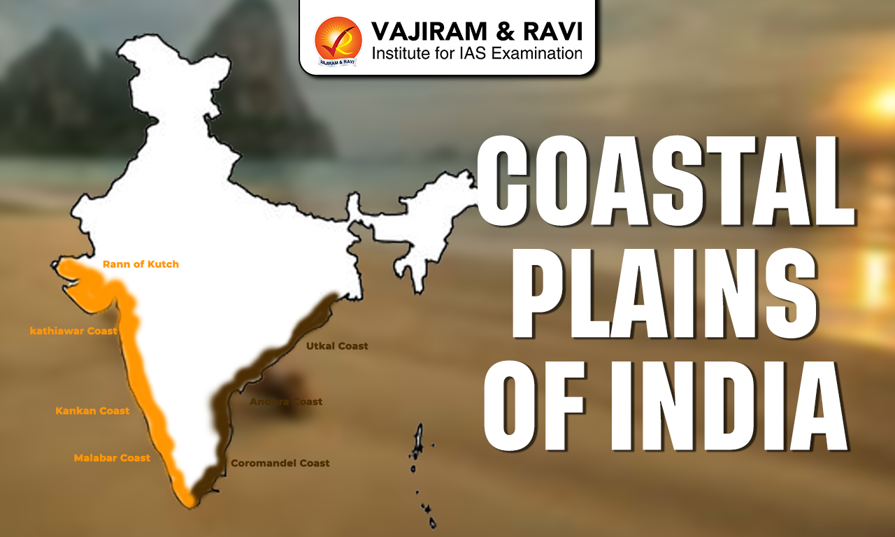
- The Coastal Plains of India are divided into two main parts: the Western Coastal Plains and the Eastern Coastal Plains.
- The Western Coastal Plains lie along the Arabian Sea, while the Eastern Coastal Plains are along the Bay of Bengal.
- Both coastal plains meet at the southernmost tip of India, Kanyakumari.
- These plains are located on either side of the Deccan Plateau and form a long stretch of low-lying land
- They extend for about 6,150 km, from the Rann of Kutch in the west to West Bengal in the east
- India’s total coastline is about 7,516 km, including the mainland and island groups like Lakshadweep and Andaman and Nicobar Islands
- These coastal plains are flat and low-lying areas formed due to ancient geological changes, including the breaking of the Gondwana land.
- The coastline of India is mostly straight and regular in shape.
- The coastal plains touch around 13 states and Union Territories of India.
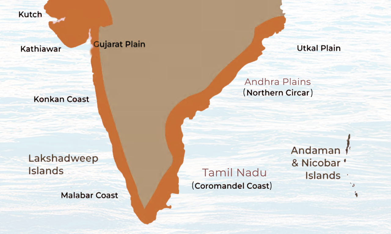
- Both the Western and Eastern Coastal Plains are further divided into smaller regions based on their physical features. The Coastal Plain of India Map has been attached below:
Western and Eastern Coastal Plains
Comparison of Western and Eastern Coastal Plains has been discussed below:
| Western and Eastern Coastal Plains | ||
|
Feature |
Western Coastal Plains |
Eastern Coastal Plains |
|
Width |
Narrower |
Wider |
|
Location |
Between Western Ghats & Arabian Sea |
Between Eastern Ghats & Bay of Bengal |
|
Continuity |
Broken by hills and mountains |
More continuous from north to south |
|
River Features |
Short rivers form estuaries |
Large rivers form wide deltas |
|
Harbours |
Good natural harbours present |
Fewer natural harbours |
|
Rainfall |
Mainly from Southwest Monsoon |
From both Southwest & Northeast Monsoon |
|
Coast Nature |
Mostly rocky with backwaters (Malabar coast) |
Mostly sandy with dunes & lagoons |
|
Examples |
Konkan & Malabar coasts |
Coromandel & Northern Circar coasts |


The Western Coastal Plains of India
- The Western Coastal Plains of India stretch from the Gulf of Khambhat in the north to Kanyakumari in the south.
- These plains lie between the Western Ghats and the Arabian Sea, forming a narrow strip of land along the western edge of India.
- From north to south, the coast is divided into three parts
- Konkan Coast
- Karnataka Coast (also called Kanara Coast)
- Malabar Coast
- These coastal plains pass through states like Gujarat, Maharashtra, Goa, Karnataka, and Kerala.
- The plains are relatively narrow, with an average width of about 50-65 km, though they become slightly wider in the northern and southern parts.
- Many short rivers flow down from the Western Ghats and deposit sediments (alluvium), helping in the formation of these plains.
- The coastline is irregular and dotted with coves, creeks, and estuaries, which create natural inlets and sheltered water bodies.
- Important estuaries are formed by rivers like the Narmada River and Tapi River.
- The Malabar Coast in Kerala is well known for its backwaters, lagoons, and lakes, with Vembanad Lake being the largest.
- This coast is called a submergent coastline, meaning parts of the land have sunk below sea level, creating ideal natural conditions for the development of harbours and ports.
- Major ports like Mumbai Port and Kochi Port are located along this coast.
- The region has a humid tropical climate with heavy rainfall, especially during the monsoon season, supporting rich vegetation and biodiversity. The Western Coastal Plain of India Map has been attached below:
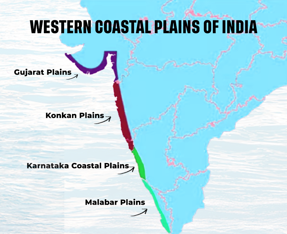
Sub-Divisions of Western Coastal Plains
Based on their physical features and geological structure, these can be further divided into the following subdivisions:
Kutch Peninsula
- The Kutch Peninsula is located in the northwestern part of Gujarat and forms an important part of India’s western coastal region
- In the past, this region was actually an island, surrounded by shallow seas and lagoons
- Over time, sediments brought by the Indus River gradually filled these water bodies, connecting the island to the mainland.
- Today, the region has a dry and semi-arid climate due to very low rainfall and strong winds.
- The landscape is mostly barren and sandy, with features like sand dunes, flat plains, and scattered rocky hills.
- The area shows clear signs of wind action, which shapes the land and creates desert-like conditions.
- The Kutch region is bordered by two unique salt marsh areas known as the Great Rann and the Little Rann.
- The Great Rann of Kutch lies to the north and is a vast, flat, salt-covered plain that remains dry for most of the year.
- During the monsoon season, rivers like the Luni River and Banas River flood this area, turning it into a shallow wetland.
- The Little Rann of Kutch is located to the southeast and is considered an extension of the Great Rann.
- This region is also ecologically important, as it supports wildlife like the Indian wild ass and several migratory birds.
Kathiawar Peninsula
- The Kathiawar Peninsula is located to the south of the Kutch Peninsula in Gujarat and forms an important part of India’s western coastal region.
- It is surrounded by the Little Rann of Kutch on the eastern side and the Nal Basin in the northeast.
- The central part of this peninsula is made up of elevated land known as the Mandav Hills, from where many small rivers and streams flow outward in different directions.
- This pattern of rivers flowing outwards from a central high point is called radial drainage, which is a key feature of this region.
- The highest point here is the Girnar Hills, which rises to about 1,117 meters and is believed to be of volcanic origin.
- The southern part of the peninsula is occupied by the Gir Range, which is covered with dense forests.
- This region is world-famous as the only natural habitat of the Asiatic lion, protected inside the Gir National Park.
- The Kathiawar Peninsula has a mix of hills, plateaus, and coastal plains, making its landscape quite diverse.
- The climate here is mostly dry to semi-arid, but the forested areas receive moderate rainfall.
Gujarat Plain
- The Gujarat Plain is located to the east of the Kutch Peninsula and Kathiawar Peninsula, covering a large part of southern Gujarat.
- It also extends along the coastal areas of the Gulf of Khambhat.
- This plain has been formed over time by the deposition of sediments brought by major rivers like the Narmada River, Tapi River, Mahi River, and Sabarmati River.
- The land here is generally low-lying, and most areas are below 150 meters above sea level.
- The slope of the plain is gentle and mostly towards the west and southwest, which helps rivers flow into the Arabian Sea.
- The Gujarat Plain can be divided into two main parts based on its features:
- The eastern part is made up of rich alluvial soil, making it fertile and suitable for agriculture
- The coastal part is covered with wind-blown sand (loess), giving it a more dry and semi-arid character
- Due to its fertile soil, crops like cotton, groundnut, and wheat are commonly grown in the eastern region.
- The coastal areas, though less fertile, are important for salt production and trade activities.
- This region also supports several towns and ports due to its proximity to the sea.
Konkan Plain
- The Konkan Plain is a part of the western coastal plains of India and lies to the south of the Gujarat Plain.
- It stretches from Daman in the north to Goa in the south, covering a distance of about 500 km.
- The plain is relatively narrow, with its width ranging between 50 to 80 km.
- It lies between the Western Ghats on the east and the Arabian Sea on the west.
- The coastline here shows clear signs of marine erosion, which has shaped features like cliffs, rocky shores, reefs, and small offshore islands.
- The Konkan coast is known for its beautiful beaches, small bays, and natural inlets, making it an important tourist region.
- Mumbai, one of India’s major cities, is located in this region and was originally a group of islands that were later joined together through land reclamation.
- The Thane Creek near Mumbai forms a natural harbour, which has supported the growth of ports and trade.
- Several short and fast-flowing rivers descend from the Western Ghats and drain into the Arabian Sea along this coast.
- The region experiences heavy rainfall during the monsoon, leading to lush green landscapes, especially in the ghats.
Karnataka Coastal Plain
- The Karnataka Coastal Plain is a part of the western coastal plains of India and lies to the south of the Konkan Plain.
- It stretches from Goa to Mangaluru (Mangalore) and is about 225 km long.
- This plain is very narrow, with an average width of around 30-50 km, though it becomes slightly wider (up to about 70 km) near Mangaluru.
- It lies between the Western Ghats on the east and the Arabian Sea on the west.
- In the central part, many spurs (small ridges) extend from the Western Ghats towards the sea, making the plain even narrower in some areas.
- Several short rivers and streams originate in the Western Ghats and flow rapidly towards the sea due to steep slopes.
- These rivers often form beautiful waterfalls while descending from the hills.
- A famous example is Jog Falls, formed by the Sharavati River, where water drops from a height of about 253 meters, making it one of the highest waterfalls in India.
- The coastal area shows features shaped by the sea, such as beaches, cliffs, and marine landforms.
- The region receives heavy rainfall during the monsoon, especially because of the Western Ghats, leading to dense vegetation and rich biodiversity.
- Important towns and ports like Mangaluru have developed here due to access to the sea and natural harbours.
Kerala Coastal Plain
- The Kerala Coastal Plain, also called the Malabar Plain, is an important part of the western coastal plains of India.
- It extends from Mangaluru in the north to Kanyakumari in the south, covering a distance of about 500 km.
- Compared to the Karnataka coastal plain, this region is wider and more extensive.
- It is a low-lying area, often close to sea level, which makes it rich in water bodies.
- One of the most unique features of this plain is the presence of backwaters, lagoons, lakes, and sandbars (spits).
- The backwaters of Kerala are locally known as “kayals”, which are shallow water channels running parallel to the coast.
- These backwaters are formed due to the action of waves and rivers, creating a network of calm waterways.
- The most important and largest backwater is Vembanad Lake, which is about 75 km long and 5-10 km wide.
- Vembanad Lake is also a Ramsar site, highlighting its importance for biodiversity and wetland conservation.
- These backwaters are widely used for transport, fishing, and tourism, especially houseboat tourism in Kerala.
- The region receives heavy rainfall during the monsoon, making it green, fertile, and rich in vegetation.
- Coconut trees, paddy fields, and spices are commonly found here, supporting local agriculture.
The Eastern Coastal Plains of India
- The Eastern Coastal Plains of India lie between the Eastern Ghats and the Bay of Bengal.
- These plains extend from the region near the Subarnarekha River in the north (around the West Bengal-Odisha border) to Kanyakumari in the south.
- Unlike the Western Ghats, the Eastern Ghats are not continuous, which allows rivers to flow easily and form wide plains.
- The Eastern Coastal Plains are generally wider than the Western Coastal Plains, with an average width of about 100-120 km.
- In delta regions, they can become very wide (up to 200 km), while in some places they narrow down to around 30-35 km.
- These plains have been formed mainly by the deposition of sediments (alluvium) brought by major rivers like the Mahanadi River, Godavari River, Krishna River, and Cauvery River.
- Due to heavy deposition, these rivers form large and fertile deltas, making the region very suitable for agriculture.
- The coast is known as an emergent coastline, which means it has fewer natural harbours and is less suitable for port development compared to the western coast.
- Important features of this coast include lagoons and lakes like Chilika Lake and Pulicat Lake.
- The climate is generally hot and humid, with temperatures often rising above 30°C.
- This region receives rainfall from both the southwest monsoon and the northeast monsoon, making it well-watered.
- The plains are often divided into different sections such as the Mahanadi delta region, Godavari-Krishna delta region, Coromandel Coast, and the southern coastal plains.
- Due to fertile soil and good water supply, crops like rice, sugarcane, and coconut are widely grown here.
Sub-Divisons of Eastern Coastal Plains
Based on their physical features and landforms, the Eastern Coastal Plains can be further divided into the following subdivisions.
Utkal Plain
- The Utkal Plain is a part of the Eastern Coastal Plains and lies along the coast of Odisha.
- It mainly includes the coastal areas of Odisha, especially the region formed by the Mahanadi River delta.
- This plain has been formed by the deposition of sediments brought by rivers, making the soil very fertile and suitable for agriculture.
- One of the most important features of this region is Chilika Lake, which is the largest brackish water lagoon in India.
- The size of Chilika Lake changes with seasons, becoming larger during the monsoon and smaller in winter.
- This lake is also a Ramsar site and is famous for its rich biodiversity, especially migratory birds.
- The plain is mostly flat and low-lying, but in some areas, especially to the south of Chilika Lake, small low hills can be seen.
- The region receives good rainfall and supports crops like rice, making it an important agricultural area.
Andhra Plain
- The Andhra Plain is a part of the Eastern Coastal Plains and lies to the south of the Utkal Plain, extending up to Pulicat Lake.
- It mainly covers the coastal region of Andhra Pradesh.
- The most important feature of this plain is the formation of large deltas by the Godavari River and Krishna River.
- Over time, these two river deltas have merged together, forming a broad and fertile plain.
- Due to continuous deposition of sediments, the coastline in this region is gradually moving forward into the sea.
- This change can be seen in the case of Kolleru Lake, which was once near the coast but is now located further inland.
- The coastline here is mostly straight and smooth, with very few natural inlets or bays.
- Because of this, the region lacks natural harbours, making port development more difficult compared to the western coast.
- However, some important ports like Visakhapatnam Port and Machilipatnam Port have developed here.
- Pulicat Lake is partly separated from the sea by a long sandy strip called Sriharikota Island, which is also known for hosting a major space launch centre.
- The plain is very fertile and agriculturally important, especially for crops like rice due to rich alluvial soil and water availability.
Tamil Nadu Plain
- The Tamil Nadu Plain is a part of the Eastern Coastal Plains and lies along the coast of Tamil Nadu.
- It extends from Pulicat Lake in the north to Kanyakumari in the south, covering a distance of about 675 km.
- The plain has an average width of around 100 km, though it becomes wider in some areas.
- The most important feature of this region is the Cauvery Delta, formed by the Cauvery River.
- In the delta region, the plain becomes quite wide (around 130 km) and is extremely fertile due to rich alluvial soil.
- Because of fertile land and well-developed irrigation systems, this region is known as the “Granary of South India”.
- Crops like rice, sugarcane, and pulses are widely grown here, making it an important agricultural zone.
- The coastline here is mostly straight and smooth, with fewer natural harbours.
- The region receives rainfall mainly from the northeast monsoon, which is important for agriculture.
- Important cities like Chennai are located along this coastal plain.
- Fishing and coastal trade are also important economic activities in this region.
Coastal Plains of India Significance
- The Coastal Plains of India have fertile soil, making them ideal for agriculture, with rice as the main crop and coconut trees widely grown along the coast.
- These regions have many ports and harbours, which support trade and connect India with other countries, making them important for transportation and the economy.
- Coastal areas are rich in natural resources, including mineral oil and natural gas in the Krishna-Godavari Basin, and monazite sands in Kerala used for nuclear energy.
- Fishing and salt production are major occupations, especially in coastal regions like Gujarat.
- Coastal plains are also important for tourism, with attractions like the backwaters of Kerala and the beaches of Goa drawing many visitors.
![]() Last updated on June, 2026
Last updated on June, 2026
→ UPSC Prelims Result 2026 is now out.
→ UPSC IFoS Prelims Result 2026 is now out.
→ Enroll in Vajiram & Ravi’s UPSC Mains Test Series 2026 for structured answer writing practice, expert evaluation, and exam-oriented feedback.
→ Join Vajiram & Ravi’s UPSC Mentorship Program 2026 for personalized guidance, strategy planning, and one-to-one support from experienced mentors.
→ Join Vajiram & Ravi’s UPSC Mentorship Program 2027 for personalized guidance, strategy planning, and one-to-one support from experienced mentors.
→ UPSC Prelims Provisional Answer Key 2026 out for GS Paper 1 and CSAT.
→ UPSC Prelims Question Paper 2026 Out, Download GS Paper 1 PDF conducted on 24th May 2026.
→ UPSC Mains 2026 will be conducted from 21st August 2026 onwards, and UPSC Prelims 2027 will be held on 23rd May 2027.
→ UPSC Final Result 2025 is now out.
→ UPSC has released UPSC Toppers List 2025 with the Civil Services final result on its official website.
→ Anuj Agnihotri secured AIR 1 in the UPSC Civil Services Examination 2025.
→ UPSC Notification 2026 & UPSC IFoS Notification 2026 is now out on the official website at upsconline.nic.in.
→ UPSC Calendar 2027 has been released.
→ Check out the latest UPSC Syllabus 2026 here.
→ The UPSC Selection Process is of 3 stages-Prelims, Mains and Interview.
→ Shakti Dubey secures AIR 1 in UPSC CSE Exam 2024.
→ Also check Best UPSC Coaching in India
Coastal Plains of India FAQs
Q1. What are the Coastal Plains of India?+
Q2. How are the Coastal Plains of India divided?+
Q3. What is the main difference between Western and Eastern Coastal Plains?+
Q4. What are the major rivers forming deltas in the Eastern Coastal Plains?+
Q5. What are backwaters and where are they found?+
Tags: coastal plains of india geography geography notes