Saser Kangri, Location, Geographical Features, Flora, Fauna, Importance

Saser Kangri

Saser Kangri  is the highest peak of the Saser Muztagh range, an eastern sub-range of the Karakoram Mountain System. Rising to an elevation of 7,672 metres, it is among the highest peaks of India and the highest summit of the Saser Muztagh range. Located in the eastern Karakoram region of the Union Territory of Ladakh, it represents the extreme high-altitude cold desert environment of the Trans-Himalayas. The peak is important due to its glaciers, contribution to the Indus river system, fragile biodiversity and strategic geographical location.

Saser Kangri Location

Saser Kangri is located in the Saser Muztagh range of the Karakoram Mountains in Ladakh.

  • It lies in the northeastern part of Ladakh, near the Karakoram Pass, an important mountain pass connecting Ladakh with Central Asia.
  • The peak is situated in the eastern Karakoram region, close to the Siachen Glacier, one of the world’s longest non-polar glaciers.
  • It forms part of the Trans-Himalayan region, characterised by high-altitude cold deserts, low precipitation and extreme climatic conditions.
  • Its location near important mountain routes and sensitive border regions gives it strategic significance.

Saser Kangri Geographical Features

Saser Kangri reflects the rugged physical characteristics of the Karakoram mountain system.

  • It is part of a young fold mountain system formed due to the collision of the Indian Plate with the Eurasian Plate.
  • The region is characterised by steep slopes, sharp ridges, deep valleys and rocky peaks shaped by tectonic activity and glacial erosion.
  • The summit remains snow-covered for most of the year due to its extreme elevation and harsh climatic conditions.
  • The surrounding landscape contains glaciers, permanent snowfields and moraines, which indicate the dominance of glacial processes.
  • Unlike the wetter Himalayan regions, the eastern Karakoram has a dry landscape due to its location in the rain-shadow zone of the Himalayas.

Saser Kangri Drainage System

Saser Kangri forms part of the Indus River Basin.

  • Meltwater from glaciers and snowfields around the peak feeds mountain streams of eastern Karakoram.
  • These streams contribute to the Nubra River, which flows into the Shyok River. The Shyok River is an important tributary of the Indus River.
  • Seasonal glaciers and snowmelt play an important role in maintaining river discharge during summer months.
  • The glacier-fed drainage system supports ecosystems and limited human settlements in the otherwise arid Ladakh region.

Saser Kangri Climate

Saser Kangri  experiences a severe high-altitude cold desert climate.

  • Winters are extremely cold, with prolonged freezing conditions and heavy snowfall at higher elevations.
  • The region receives limited precipitation due to its location in the rain-shadow zone of the Himalayas.
  • Most precipitation occurs in the form of snowfall rather than rainfall.
  • Strong winds, low atmospheric pressure and reduced oxygen availability make the environment highly challenging.
  • Large variations between daytime and nighttime temperatures occur due to the dry continental conditions.

Saser Kangri Flora and Fauna

The extreme environment supports a specialised Trans-Himalayan ecosystem.

  • Vegetation is sparse and mainly consists of alpine grasses, shrubs and cold-resistant plants adapted to low moisture availability.
  • Plant growth is mainly found in valleys and areas near streams where water availability is higher.
  • The region supports wildlife species such as snow leopard, Himalayan ibex, bharal (blue sheep), marmot and red fox.
  • These species possess adaptations that allow survival in extreme cold, low oxygen levels and limited food availability.

Saser Kangri Environmental Importance 

Saser Kangri represents a fragile high-altitude ecosystem of the Karakoram with importance for water security, biodiversity and climate studies.

  • Glaciers and snowfields act as natural freshwater reservoirs and contribute to the Nubra-Shyok-Indus river system.
  • Changes in glacier extent and snowfall patterns provide evidence of climatic changes occurring in the Himalayan region.
  • The region provides habitat for rare cold-adapted species of the Trans-Himalayan ecosystem.
  • Its glaciers and landforms help scientists study glacial processes, mountain evolution and climate variability.
  • Its location in the eastern Karakoram near important passes makes it significant from India’s geographical and security perspective.

Saser Kangri Climate Change Concerns

Climate change is affecting the fragile environment of the Saser Kangri  region.

  • Rising temperatures may accelerate glacier retreat and reduce long-term freshwater storage.
  • Changes in glacier melt patterns can influence seasonal river flows in the Indus basin.
  • Increasing instability of glaciers may enhance risks of avalanches and other high-altitude hazards.
  • Warming conditions may disturb habitats of species adapted to extreme cold environments.

Saser Kangri FAQs

Q1: Where is Saser Kangri located?

Ans: Saser Kangri is located in the Saser Muztagh range of the Karakoram Mountain System in the Union Territory of Ladakh, India.

Q2: What is the elevation of Saser Kangri ?

Ans: Saser Kangri has an elevation of 7,672 metres.

Q3: Which mountain system does Saser Kangri belong to?

Ans: Saser Kangri belongs to the Karakoram Mountain System.

Q4: Which river basin is associated with Saser Kangri?

Ans: Its glacier melt contributes to the Nubra-Shyok river system, which forms part of the Indus River Basin.

Q5: Why is Saser Kangri geographically significant?

Ans: Saser Kangri is significant because it represents the extreme high-altitude environment of the Karakoram region, contributes to the Indus River Basin through glacier-fed streams and highlights the ecological sensitivity of the Trans-Himalayan cold desert ecosystem.

Gobi Desert, Location, Formation, Climate, Flora, Fauna

Gobi Desert

The Gobi Desert is one of the largest deserts in Asia and the largest cold desert in Asia. Covering about 1.3 million sq. km, it extends across southern Mongolia and northern China. Unlike typical hot deserts, the Gobi is dominated by rocky plains, gravel-covered surfaces and barren landscapes rather than vast sand dunes. It was formed mainly due to the combined effects of continentality and the rain-shadow effect of the Himalayas and the Tibetan Plateau. The desert is globally important for its unique biodiversity, rich dinosaur fossil deposits, mineral resources and its role as a major source of dust storms in East Asia.

Gobi Desert Location

The Gobi Desert is located in East Asia and extends across southern Mongolia and northern China.

  • It lies in the interior of the Asian continent and forms part of the temperate desert biome.
  • It stretches from the Tien Shan Mountains in the west to the Greater Khingan Mountains in the east.
  • The Altai Mountains and the Mongolian Plateau lie to its north, while the Tibetan Plateau forms its southern boundary.

Gobi Desert Formation

The Gobi Desert was formed due to a combination of its continental location and the rain-shadow effect created by surrounding mountain ranges. These factors prevent adequate moisture from reaching the region, resulting in an extremely dry climate.

  • Rain-shadow Effect: The Himalayas and the Tibetan Plateau block moisture-laden monsoon winds from the Indian Ocean. As the winds lose most of their moisture on the southern slopes of these mountains, very little rainfall reaches the Gobi Desert.
  • Continental Location: The Gobi lies deep inside the Asian continent, far from major oceans. By the time air masses reach the region, they have already lost much of their moisture, resulting in very low precipitation.
  • High Evaporation: Although the region receives limited rainfall, low humidity, strong winds and dry air increase moisture loss, making the landscape even more arid.

Due to these combined factors, the Gobi receives less than 200 mm of annual rainfall, preventing the growth of dense vegetation and maintaining its cold desert environment.

Gobi Desert Geographical Features

The Gobi Desert exhibits several distinctive physical features that reflect its unique cold desert environment and geological history.

  • Predominantly Rocky Landscape: Unlike many deserts, the Gobi is mainly covered by rocky plains, gravel-covered surfaces and barren plateaus, while sand dunes occupy only a small part of the desert.
  • Varied Relief: The landscape includes mountain ranges, broad basins, dry valleys, escarpments and isolated hills, giving the region a diverse topography.
  • Cold Desert Environment: The desert remains largely barren because of low rainfall, extreme temperatures and sparse vegetation.
  • Rich Fossil Deposits: The Gobi is internationally renowned for its dinosaur fossils and fossilised eggs. The Flaming Cliffs (Bayanzag) are among the world’s most important palaeontological sites.
  • Active Geomorphological Processes: Strong winds continuously shape the landscape through weathering, erosion and the movement of sand and dust, creating unique desert landforms.
  • Harsh Physical Conditions: Low humidity, strong winds, frequent dust storms and large differences between day and night temperatures make it one of the most challenging environments for life.

Gobi Desert Climate

The Gobi Desert experiences an extreme continental climate with large seasonal and daily variations in temperature.

  • Winters are long and extremely cold, while summers are short and warm.
  • Winter temperatures may fall below –40°C, whereas summer temperatures can exceed 40°C.
  • Annual rainfall is generally less than 200 mm, with most of it occurring during summer.
  • Strong winds frequently produce dust storms, especially during spring.
  • Low humidity and high evaporation make the region highly arid.

Gobi Desert Drainage System

The Gobi Desert has a poorly developed drainage system because of its dry climate.

  • Most rivers are seasonal and flow only after rainfall or snowmelt.
  • Water is mainly available through springs, oases and temporary lakes.
  • Many streams end in inland (endorheic) basins without reaching the sea.
  • Groundwater is an important source of water for local communities and wildlife.

Gobi Desert Flora

The vegetation of the Gobi Desert is sparse and well adapted to its cold and arid environment.

  • It is dominated by drought-resistant shrubs, hardy grasses and low-growing bushes that can survive with very little rainfall.
  • Saxaul is the most characteristic plant of the Gobi Desert and plays an important role in stabilising soil and preventing desertification.
  • Many plants have deep root systems, small leaves or waxy surfaces to reduce water loss and withstand strong winds.
  • Vegetation is relatively denser around oases, river valleys and seasonal water sources.
  • During occasional rainfall, short-lived grasses and wildflowers bloom briefly, providing food for grazing animals.

Gobi Desert Fauna

Despite its harsh environment, the Gobi Desert supports several rare and endangered animal species.

  • Mammals include the Wild Bactrian Camel, Gobi Bear, Snow Leopard, Mongolian Wild Ass (Khulan) and Goitered Gazelle.
  • Reptiles such as lizards and snakes are commonly found.
  • Birds include vultures, eagles, falcons and bustards.
  • Many species have developed special adaptations to survive extreme temperatures and limited water availability.

Gobi Desert Importance

Beyond its distinctive physical features, the Gobi Desert holds immense ecological, scientific and economic importance.

  • It contains some of the world’s richest dinosaur fossil deposits, providing valuable insights into prehistoric life and the evolution of reptiles.
  • The desert is rich in coal, copper, gold and rare earth elements, making it an important mining region in Mongolia and China.
  • Its vast open landscapes and high solar radiation provide significant potential for solar and wind energy development.
  • Dust storms originating from the Gobi transport fine mineral particles over long distances, influencing air quality, weather patterns and nutrient cycles across East Asia and the North Pacific.
  • It supports the traditional nomadic pastoral lifestyle, with camel, sheep and goat rearing forming an important source of livelihood.
  • The Gobi also serves as an important natural laboratory for studying desertification, climate change, arid-land ecology and the adaptation of plants and animals to extreme environments.

Gobi Desert Climate Change Concerns

Climate change and human activities are increasing environmental pressure on the Gobi Desert.

  • Rising temperatures are accelerating the expansion of desert areas into neighbouring grasslands.
  • Overgrazing has reduced vegetation cover, leading to greater soil erosion and land degradation.
  • Dust storms are becoming more frequent and are affecting air quality in China, Mongolia, the Korean Peninsula and Japan.
  • Increasing evaporation and changing rainfall patterns are worsening water scarcity.
  • Mining and infrastructure development are putting additional pressure on the fragile desert ecosystem.

Gobi Desert FAQs

Q1: Where is the Gobi Desert located?

Ans: The Gobi Desert extends across southern Mongolia and northern China in East Asia.

Q2: Why is the Gobi Desert called a cold desert?

Ans: The Gobi Desert is called a cold desert because it experiences extremely cold winters, low rainfall and occasional snowfall.

Q3: Why does the Gobi Desert receive very little rainfall?

Ans: The Himalayas and the Tibetan Plateau block moisture-laden winds, while the desert’s inland location limits the supply of moisture from the oceans.

Q4: Which endangered animals are found in the Gobi Desert?

Ans: The Wild Bactrian Camel, Gobi Bear, Snow Leopard, Mongolian Wild Ass (Khulan) and Goitered Gazelle are among the important animals found in the Gobi Desert.

Q5: Why is the Gobi Desert important?

Ans: The Gobi Desert is important for it’s unique desert ecosystem, rich dinosaur fossil deposits, rare wildlife, valuable mineral resources and it’s influence on the dust storms across East Asia.

Nanda Devi Biosphere Reserve, Location, Flora, Fauna, Significance

Nanda Devi Biosphere Reserve

The Nanda Devi Biosphere Reserve is one of India’s most important protected mountain ecosystems. Located in the Western Himalayas, it is known for its spectacular landscapes, rich biodiversity, glaciers, alpine meadows and endemic Himalayan flora and fauna. The reserve is recognised under UNESCO’s Man and the Biosphere (MAB) Programme and includes the Nanda Devi National Park and the Valley of Flowers National Park, both of which are designated as UNESCO World Heritage Sites.

Nanda Devi Biosphere Reserve Location

The Nanda Devi Biosphere Reserve is situated in the Western Himalayas of Uttarakhand.

  • It extends across the Chamoli, Bageshwar and Pithoragarh districts.
  • The reserve surrounds Nanda Devi, India’s second-highest mountain.
  • It lies within the upper catchments of the Alaknanda River.
  • The reserve comprises a Core Zone, Buffer Zone and Transition Zone, following the UNESCO Biosphere Reserve model.

Nanda Devi Biosphere Reserve Geographical Features

The Nanda Devi Biosphere Reserve exhibits the characteristic features of a high-altitude Himalayan ecosystem.

  • It consists of rugged mountain ranges, deep gorges, glaciers and snow-covered peaks.
  • Elevation ranges from about 1,800 metres to over 7,800 metres, resulting in diverse climatic and ecological conditions.
  • The Nanda Devi Sanctuary, enclosed by high mountain peaks, forms a unique natural basin.
  • Numerous glaciers, including the Uttari Rishi, Dakshini Rishi, Trisul and Ramani glaciers, occur within the reserve.
  • Alpine meadows (Bugyals), temperate forests and sub-alpine vegetation dominate the landscape.

Nanda Devi Biosphere Reserve Drainage System

The Nanda Devi Biosphere Reserve plays an important role in the Himalayan river system.

  • The Rishi Ganga River originates from the glaciers within the Nanda Devi Sanctuary. It joins the Dhauliganga River, which is a tributary of the Alaknanda River.
  • The Alaknanda later joins the Bhagirathi at Devprayag to form the Ganga River.
  • Snow and glacier melt help sustain river flows, especially during the dry season.

Nanda Devi Biosphere Reserve Climate

The Nanda Devi Biosphere Reserve experiences a typical high-altitude Himalayan climate.

  • Winters are long and extremely cold, with heavy snowfall at higher elevations.
  • Summers are short and cool.
  • Most precipitation is received during the southwest monsoon, while higher elevations also receive snowfall from western disturbances.
  • Climate varies significantly with altitude, creating distinct ecological zones.

Nanda Devi Biosphere Reserve Flora

The Nanda Devi Biosphere Reserve supports exceptional floral diversity because of its wide altitudinal range.

  • Temperate forests contain oak, deodar, blue pine, fir, spruce and rhododendron.
  • Sub-alpine and alpine zones support birch forests and extensive alpine meadows.
  • The Valley of Flowers is famous for its seasonal bloom of wildflowers.
  • Important medicinal plants include Aconitum, Picrorhiza kurroa (Kutki), Nardostachys jatamansi (Jatamansi) and Atis.

Nanda Devi Biosphere Reserve Fauna

The Nanda Devi Biosphere Reserve is home to many rare and threatened Himalayan species. Several species are protected under the Wild Life (Protection) Act, 1972 and the IUCN Red List.

  • Mammals include the Snow Leopard, Himalayan Musk Deer, Himalayan Tahr, Bharal (Blue Sheep), Asiatic Black Bear and Common Leopard.
  • Important birds include the Himalayan Monal, Snow Partridge, Golden Eagle and various pheasants.

Nanda Devi Biosphere Reserve Significance

The Nanda Devi Biosphere Reserve is one of India’s most important protected mountain ecosystems because of its ecological, hydrological and conservation value.

  • It is recognised as a UNESCO Biosphere Reserve under the Man and the Biosphere (MAB) Programme.
  • It includes the Nanda Devi National Park and the Valley of Flowers National Park, both designated as UNESCO World Heritage Sites.
  • It conserves a rich diversity of Himalayan flora and fauna, including several rare, endemic and threatened species.
  • Its glaciers and snowfields support the upper catchments of the Ganga river system, contributing to long-term water security.
  • It protects fragile Himalayan ecosystems, including temperate forests, alpine meadows and glacial landscapes.
  • It serves as an important site for scientific research on biodiversity conservation, glacier dynamics and the impacts of climate change.

Nanda Devi Biosphere Reserve Climate Change Concerns

Climate change poses significant challenges to the Nanda Devi Biosphere Reserve.

  • Rising temperatures are accelerating glacier retreat.
  • Changes in snowfall patterns are affecting water availability and ecosystem stability.
  • Increasing frequency of Glacial Lake Outburst Floods (GLOFs) threatens downstream communities.
  • Alpine species are shifting to higher elevations due to warming temperatures.
  • Extreme weather events are increasing ecological vulnerability.

Nanda Devi Biosphere Reserve FAQs

Q1: Where is the Nanda Devi Biosphere Reserve located?

Ans: Nanda Devi Biosphere Reserve is located in the Western Himalayas of Uttarakhand and extends across the Chamoli, Bageshwar and Pithoragarh districts.

Q2: Which protected areas are included in the Nanda Devi Biosphere Reserve?

Ans: Nanda Devi Biosphere Reserve includes the Nanda Devi National Park and the Valley of Flowers National Park, both of which are UNESCO World Heritage Sites.

Q3: Which river system is associated with the Nanda Devi Biosphere Reserve?

Ans: The Rishi Ganga originates within the reserve and joins the Dhauliganga, which flows into the Alaknanda River, a major tributary of the Ganga.

Q4: Why is the Nanda Devi Biosphere Reserve environmentally important?

Ans: It conserves a fragile Himalayan ecosystem, protects rare and endemic species, supports the upper catchments of the Ganga river system and serves as an important site for biodiversity and climate change research.

Q5: Under which UNESCO programme is the Nanda Devi Biosphere Reserve recognised?

Ans: Nanda Devi Biosphere Reserve is recognised under UNESCO’s Man and the Biosphere (MAB) Programme as a Biosphere Reserve.

Battle of Bedara 1759, Background, Causes, Outcome, Significance

Battle of Bedara

The Battle of Bedara (also known as the Battle of Chinsurah) was fought on 25 November 1759 in Bengal between the British East India Company and the Dutch East India Company. The British, led by Colonel Francis Forde, defeated the Dutch forces, ending Dutch ambitions of establishing political dominance in India. The victory further strengthened British control over Bengal after the Battle of Plassey (1757) and marked another milestone in the expansion of British rule in India.

Battle of Bedara Background

The Battle of Bedara took place in the aftermath of the Battle of Plassey (1757), which established the British East India Company as the dominant political power in Bengal. Although the Dutch East India Company had trading settlements at Chinsurah (Hooghly), they were concerned about the rapidly increasing influence of the British.

Nawab Mir Jafar, who had been placed on the throne by the British, grew dissatisfied with their growing interference in Bengal's administration. Hoping to reduce British dominance, he secretly sought support from the Dutch. Encouraged by this opportunity, the Dutch sent troops and warships from Batavia (present-day Jakarta) to Bengal.

The arrival of Dutch forces alarmed the British East India Company, which decided to confront them before they could strengthen their position in Bengal.

Battle of Bedara 1759 Causes

The Battle of Bedara (1759) was fought due to the growing rivalry between the British East India Company and the Dutch East India Company over political influence and commercial dominance in Bengal.

  • British dominance after Plassey (1757): The British became the most powerful European force in Bengal.
  • Dutch trade interests: The Dutch sought to protect and expand their commercial interests in Bengal.
  • Mir Jafar's dissatisfaction: The Nawab secretly encouraged the Dutch to counter growing British influence.
  • Arrival of Dutch reinforcements: The Dutch sent troops and warships from Batavia to strengthen their position.
  • British suspicion: The British viewed the Dutch military buildup as a direct threat.
  • Control over Bengal's trade: Both companies wanted dominance over Bengal's lucrative trade routes and resources.
  • Political rivalry: Increasing competition among European powers intensified tensions in eastern India.
  • British preventive action: Colonel Francis Forde launched military operations to stop the Dutch advance, leading to the Battle of Bedara.

Battle of Bedara Events and Outcome

The Battle of Bedara was fought on 25 November 1759 near Chinsurah in Bengal, where the British East India Company decisively defeated the Dutch East India Company, ending Dutch military ambitions in India.

Key Events

  • The Dutch East India Company sent warships, European soldiers, and Indian sepoys from Batavia (present-day Jakarta) to Bengal.
  • The British East India Company, under Colonel Francis Forde, prepared to stop the Dutch advance.
  • British naval forces intercepted and engaged several Dutch ships on the Hooghly River.
  • On 25 November 1759, British and Dutch forces clashed at Bedara, near Chinsurah.
  • The disciplined British infantry and artillery outperformed the Dutch forces during the battle.
  • The Dutch suffered heavy casualties, and many of their soldiers were captured or forced to surrender.

Outcome

  • The British East India Company secured a decisive victory.
  • The defeat ended the Dutch East India Company's political and military ambitions in India.
  • The Dutch were allowed to retain only their trading settlements without political influence.
  • British supremacy in Bengal became firmly established after the victory.
  • The battle further strengthened the British position following the Battle of Plassey (1757) and paved the way for future territorial expansion in India.

Battle of Bedara Significance

The Battle of Bedara (1759) was a landmark event that consolidated the British East India Company's dominance in Bengal and eliminated the Dutch East India Company as a political rival in India.

  • Ended Dutch ambitions: The defeat permanently ended the Dutch East India Company's political and military aspirations in India.
  • Strengthened British supremacy: The victory established the British East India Company as the dominant European power in Bengal.
  • Consolidated post-Plassey gains: It reinforced British control gained after the Battle of Plassey (1757).
  • Reduced European rivalry: The battle weakened competition from other European trading companies in eastern India.
  • Increased British political influence: The British gained greater control over the Nawab of Bengal and regional administration.
  • Secured British trade interests: It ensured British dominance over Bengal's lucrative trade and strategic river routes.
  • Boosted Company confidence: The victory enhanced the military reputation of the British East India Company among Indian rulers.
  • Paved the way for expansion: It laid the foundation for the British to expand their territorial and political control across India.

Battle of Bedara FAQs

Q1: What was the Battle of Bedara?

Ans: The Battle of Bedara (also known as the Battle of Chinsurah) was fought on 25 November 1759 between the British East India Company and the Dutch East India Company in Bengal. The British won a decisive victory.

Q2: When and where was the Battle of Bedara fought?

Ans: The battle was fought on 25 November 1759 at Bedara, near Chinsurah (Hooghly) in Bengal.

Q3: Who fought the Battle of Bedara?

Ans: The battle was fought between the British East India Company, led by Colonel Francis Forde, and the Dutch East India Company.

Q4: What were the main causes of the Battle of Bedara?

Ans: The battle was caused by the growing rivalry between the British and the Dutch for political influence and commercial dominance in Bengal, along with Mir Jafar's support for the Dutch.

Q5: Who won the Battle of Bedara?

Ans: The British East India Company won the Battle of Bedara, defeating the Dutch forces decisively.

Volga River, Location, Origin, Length, Tributaries, Importance

Volga River

The Volga River is the longest river in Europe, stretching for about 3,530 km (2,194 miles) across western Russia. It originates in the Valdai Hills, northwest of Moscow, and flows southeast before emptying into the Caspian Sea near Astrakhan. Often called the "Mother Volga," the river has played a crucial role in Russia's history, economy, culture, transportation, and environmental heritage.

Volga River Origin

The Volga River originates in the Valdai Hills, located northwest of Moscow in western Russia. It begins as a small stream at an elevation of about 228 metres (748 feet) above sea level and flows southeast across European Russia. From its source, the river travels over 3,530 km before emptying into the Caspian Sea.

Volga River Drainage Basin

The Volga River Basin is one of the largest drainage basins in Europe, covering nearly 1.35 million square kilometres. Major tributaries are:

  • Kama River – The largest and longest tributary of the Volga.
  • Oka River – Joins the Volga at Nizhny Novgorod.
  • Vetluga River – An important northern tributary.
  • Sura River – Supports agriculture and settlements in central Russia.
  • Sheksna River – Connects the Volga with northern waterways.
  • Unzha River – Contributes to the upper Volga basin.

Major Cities Along the Volga River

The Volga River flows through several of Russia's largest and most important cities, making it a major centre for trade, industry, transportation, and culture. These cities have developed along the river because of its abundant water resources and navigable waterways. Together, they form the industrial and agricultural heartland of Russia while contributing significantly to the country's economy and history.

  • Tver – Located in the upper course of the Volga and known for its historical importance.
  • Nizhny Novgorod – A major industrial, commercial, and transportation hub.
  • Kazan – Capital of Tatarstan and an important cultural and educational centre.
  • Ulyanovsk – Known for manufacturing industries and historical significance.
  • Samara – One of Russia's largest industrial cities, especially for aerospace and engineering.
  • Saratov – An important agricultural, educational, and industrial city.
  • Volgograd – Famous for the Battle of Stalingrad during World War II.
  • Astrakhan – Located near the Caspian Sea, known for fishing, shipping, and the Volga Delta.

Volga River Importance

The Volga River is the lifeline of Russia and the longest river in Europe, playing a vital role in the country's economy, transportation, agriculture, history, and culture. It supports millions of people and connects major industrial and agricultural regions across western Russia.

  • Supports nearly one-fourth of Russia's agricultural production through irrigation and fertile plains.
  • Generates significant hydroelectric power from several dams and reservoirs.
  • Serves as Russia's main inland waterway, linking the Baltic Sea, Black Sea, and Caspian Sea through canals.
  • Supports major industries such as oil refining, shipbuilding, manufacturing, and fisheries.
  • Flows through important cities including Kazan, Samara, Nizhny Novgorod, Volgograd, and Astrakhan.
  • Played a crucial role during the Battle of Stalingrad in World War II, making it historically significant.
  • Known as "Mother Volga," symbolising Russian unity, resilience, and national identity.
  • Provides habitat for 260 bird species and 70 fish species, making it an important biodiversity hotspot.
  • Promotes trade, tourism, inland navigation, and regional economic development across European Russia.

Volga River FAQs

Q1: Where does the Volga River originate?

Ans: The Volga River originates in the Valdai Hills, northwest of Moscow in western Russia.

Q2: Into which sea does the Volga River flow?

Ans: The Volga River flows into the Caspian Sea through a large delta near Astrakhan.

Q3: How long is the Volga River?

Ans: The Volga River is approximately 3,530 km (2,194 miles) long, making it the longest river in Europe.

Q4: Why is the Volga River called the "Mother Volga"?

Ans: It is called "Mother Volga" because it symbolizes Russian unity, culture, resilience, and national identity, and has supported communities for centuries.

Q5: Which are the major tributaries of the Volga River?

Ans: The major tributaries are the Kama, Oka, Vetluga, and Sura Rivers.

Saltoro Kangri, Location, Geographical Features, Drainage, Environment

Saltoro Kangri

Saltoro Kangri is the highest peak of the Saltoro Range and one of the highest mountains in the Karakoram Mountain System. It rises to an elevation of 7,742 metres (25,400 feet), making it the 31st highest peak in the world. The mountain is surrounded by glaciers and remains snow-covered throughout the year. It is an important geographical feature of the Trans-Himalayan region and plays a significant role in sustaining glaciers, river systems and the fragile high-altitude ecosystem.

Saltoro Kangri Location 

Saltoro Kangri is located in the Saltoro Range, a western sub-range of the Karakoram Mountain System. Its location makes it an important geographical feature of the north-western Himalayas.

  • It is the highest peak of the Saltoro Range, which forms part of the Karakoram Mountain System.
  • It lies west of the Siachen Glacier, one of the world’s longest non-polar glaciers.
  • The peak is situated in the Ladakh region.
  • It forms part of the Trans-Himalayan region, which is characterised by high-altitude cold desert conditions.
  • The area lies close to the Actual Ground Position Line (AGPL), adding to its geographical significance.

Saltoro Kangri Geographical Features

Saltoro Kangri possesses several distinctive physical features that reflect the unique nature of high-altitude mountain environments.

  • Rising to 7,742 metres, the peak remains snow-covered throughout the year due to its extreme altitude.
  • It is part of a geologically young mountain system formed by the collision of the Indian and Eurasian tectonic plates, making the region tectonically active.
  • Permanent snowfields and glaciers dominate the landscape, supporting one of the largest concentrations of ice outside the polar regions.
  • The region is characterised by steep slopes, sharp ridges, deep valleys and rocky cliffs, making access and mountaineering extremely difficult.
  • Very low temperatures, strong winds, low oxygen levels and frequent avalanches create one of the harshest mountain environments in the world.
  • Snow and glacier melt from the region feed streams that ultimately contribute to the Indus River system.

Saltoro Kangri Drainage System

The glaciers and permanent snowfields of Saltoro Kangri play an important role in maintaining the drainage network of the north-western Himalayas.

  • Glacial meltwater forms the primary source of surface water in the region.
  • Meltwater drains into the Nubra River, which flows through the glaciated valleys of the Karakoram.
  • The Nubra River later joins the Shyok River, an important tributary of the Indus River.
  • The drainage system ultimately becomes part of the Indus River Basin, one of South Asia’s major river systems.
  • Continuous glacier melt helps sustain river flow during the summer months, supporting downstream ecosystems and water availability.

Saltoro Kangri Environmental Importance 

Saltoro Kangri is an ecologically sensitive region because of its glaciers, unique climate and fragile mountain ecosystem.

  • Freshwater Storage: The glaciers act as natural reservoirs, storing freshwater and releasing it gradually to sustain downstream river flows.
  • Climate Regulation: The extensive snow and ice cover reflects solar radiation, helping regulate the regional climate.
  • Indicator of Climate Change: Changes in glacier size and snow cover provide valuable evidence of global warming and changing climatic conditions.
  • Fragile Mountain Ecosystem: The harsh climate supports specialised cold-adapted plants and animals that are highly sensitive to environmental disturbances.
  • Water Security: The region plays an important role in maintaining water availability for areas dependent on the Indus river system.

Saltoro Kangri Climate Change Concerns 

Climate change is increasingly affecting the glaciers and ecosystems of the Saltoro Kangri region.

  • Accelerated Glacier Retreat: Rising temperatures are increasing the rate of glacier melting.
  • Changing River Flows: Variations in glacier melt may alter the seasonal discharge of rivers in the Indus basin.
  • Increase in Natural Hazards: Glacier retreat raises the risk of avalanches, landslides and the formation of glacial lakes.
  • Threat to Biodiversity: Warming temperatures can disrupt fragile high-altitude ecosystems and affect cold-adapted species.
  • Long-term Water Stress: Continued glacier loss may reduce freshwater availability in the future.

Saltoro Kangri FAQs

Q1: What is Saltoro Kangri?

Ans: Saltoro Kangri is the highest peak of the Saltoro Range in the Karakoram Mountain System. At 7,742 metres, it is the 31st highest mountain in the world.Where is Saltoro Kangri located? It is located in the Saltoro Range of the Ladakh region, west of the Siachen Glacier, in the Trans-Himalayan region.

Q2: Which river system is associated with Saltoro Kangri?

Ans: Glacier melt from Saltoro Kangri drains into the Nubra River, which joins the Shyok River, a tributary of the Indus River.

Q3: Why is Saltoro Kangri environmentally important?

Ans: Its glaciers store freshwater, support downstream river systems, regulate the regional climate and sustain a fragile high-altitude ecosystem.

Q4: How is climate change affecting Saltoro Kangri?

Ans: Rising temperatures are causing glacier retreat, altering river flows, increasing natural hazards and threatening biodiversity and long-term water security.

UPSC Daily Quiz 15 July 2026

UPSC Daily Quiz

[WpProQuiz 210]

UPSC Daily Quiz FAQs

Q1: What is the Daily UPSC Quiz?

Ans: The Daily UPSC Quiz is a set of practice questions based on current affairs, static subjects, and PYQs that help aspirants enhance retention and test conceptual clarity regularly.

Q2: How is the Daily Quiz useful for UPSC preparation?

Ans: Daily quizzes support learning, help in revision, improve time management, and boost accuracy for both UPSC Prelims and Mains through consistent practice.

Q3: Are the quiz questions based on the UPSC syllabus?

Ans: Yes, all questions are aligned with the UPSC Syllabus 2025, covering key areas like Polity, Economy, Environment, History, Geography, and Current Affairs.

Q4: Are solutions and explanations provided with the quiz?

Ans: Yes, each quiz includes detailed explanations and source references to enhance conceptual understanding and enable self-assessment.

Q5: Is the Daily UPSC Quiz suitable for both Prelims and Mains?

Ans: Primarily focused on Prelims (MCQ format), but it also indirectly helps in Mains by strengthening subject knowledge and factual clarity.

New Species of Bees

New Species of Bees

New Species of Bees Latest News

Researchers recently discovered two new species of solitary bees named Elaphropoda Triangulata and Habropoda Adi in Arunachal Pradesh.

About Elaphropoda Triangulata and Habropoda Adi

  • They are two new species of solitary bees.
  • They were discovered in Arunachal Pradesh.
  • Elaphropoda triangulata is named after the triangle-shaped markings on its abdomen.
  • Habropoda adi is named after the Adi indigenous community of Arunachal Pradesh, which inhabits the region where the bees were collected. 
  • They belong to the bee subfamily Anthophorinae, which consists largely of ground-nesting solitary bees.
    • Solitary bees are important pollinators that help maintain healthy ecosystems and support agriculture. 
    • Unlike honeybees, they do not live in colonies and usually nest alone.   
  • These bees were collected using Malaise traps, a passive sampling method that captures flying insects over extended periods and is particularly effective in detecting elusive or low-density species that conventional netting often misses.

News: TH

New Species of Bees FAQs

Q1: What are Elaphropoda triangulata and Habropoda adi?

Ans: They are two newly discovered species of solitary bees.

Q2: Where were Elaphropoda triangulata and Habropoda adi discovered?

Ans: Arunachal Pradesh.

Q3: Why is Elaphropoda triangulata named so?

Ans: It is named after the triangle-shaped markings on its abdomen.

Q4: Why is Habropoda adi named so?

Ans: It is named after the Adi indigenous community of Arunachal Pradesh.

Periyar Tiger Reserve

Periyar Tiger Reserve

Periyar Tiger Reserve Latest News

A conservation initiative in Periyar Tiger Reserve (PTR) seeks to demonstrate how the management of invasive species can protect biodiversity while simultaneously improving livelihoods of local populations.

About Periyar Tiger Reserve 

  • It is located in the Idukki district of Kerala.
  • It is set high at Cardamom Hills and Pandalam Hills of the Western Ghats, adjacent to the border with Tamil Nadu.
  • It surrounds the Periyar Lake, which was created in 1895 by building a dam across the Periyar River.
  • Terrain
    • The terrain is hilly and undulating with a maximum altitude of 2016 m. 
    • The highest peak is Kottamala (2016 m).
  • Rivers: Two major rivers, namely Periyar and Pamba, drain the area.
  • Dams: Mullaperiyar Dam is located within the PTR. 
  • Tribes: It is home to many tribal communities, including the Mannans and the Palians.
  • Vegetation: It mainly comprises tropical evergreen forests, semi- evergreen forests, moist deciduous forests, transitional fringe evergreen forests, grasslands, and eucalyptus plantations.
  • Flora: It includes Banyan, Sacred Fig, Teak, Royal Poinciana, Kino, Sandalwood, Rosewood, Mangoes, Bamboos, Jacarandas, Jamun, Tamarind, Gloriosa lily, and many more. 
  • Fauna: 
    • Several species of mammals are found here like Tiger, Gaur, Elephant, Sambar, Barking Deer, Indian Wild Dog, Mouse Deer, Wild Pig, Indian giant squirrel, Jungle cat, sloth bear, Nilgiri Tahr, ETC.
    • The major four species of primates are also found at Periyar – the rare lion-tailed macaque, the Nilgiri Langur, Gee’s Golden Langur, Common Langur, and Bonnet Macaque.
    • It is also being considered as the habitat of the elusive Nilgiri Tahr.

News: TH

Periyar Tiger Reserve FAQs

Q1: Where is the Periyar Tiger Reserve located?

Ans: Idukki district of Kerala.

Q2: In which mountain ranges is the Periyar Tiger Reserve situated?

Ans: The Cardamom Hills and Pandalam Hills of the Western Ghats.

Q3: Which two major rivers drain the Periyar Tiger Reserve?

Ans: The Periyar and Pamba rivers.

Q4: Which dam is located within the Periyar Tiger Reserve?

Ans: Mullaperiyar Dam.

Q5: Which type of forests dominate the vegetation of the Periyar Tiger Reserve?

Ans: Tropical evergreen, semi-evergreen, and moist deciduous forests.

Intron

Intron

Intron Latest News

Scientists visually tracked an RNA intron jumping from a predator to its prey, revealing insights into gene transfer across species.

About Intron

  • In some genes, not all of the DNA sequence is used to make protein.
  • Introns are noncoding sections of an RNA transcript, or the DNA encoding it, that are spliced out before the RNA molecule is translated into a protein. 
  • The sections of DNA (or RNA) that code for proteins are called exons
  • Following transcription, new, immature strands of messenger RNA, called pre-mRNA, may contain both introns and exons. 
  • The pre-mRNA molecule thus goes through a modification process in the nucleus called splicing during which the noncoding introns are cut out and only the coding exons remain. 
  • Splicing produces a mature messenger RNA molecule that is then translated into a protein. 
  • Introns are also referred to as intervening sequences. 
  • The length of introns differs among species and genes in the same species; mammals and flowering plants have multiple introns and are longer than exons. 
  • Introns may contain sequences that regulate how genes are expressed or transcribed and how mRNA is processed.

News: TH

Intron FAQs

Q1: What are introns?

Ans: Introns are noncoding sections of an RNA transcript or the DNA encoding it that are removed before protein synthesis.

Q2: Do introns code for proteins?

Ans: No, introns are noncoding sequences.

Q3: What are the protein-coding regions of a gene called?

Ans: Exons

Q4: What happens to pre-mRNA before it is translated into a protein?

Ans: Introns are removed and exons are joined together through splicing.

Intelligence Agencies of Different Countries, List, Headquarters

Intelligence Agencies of Different Countries

Intelligence Agencies of Different Countries play a crucial role in supporting national decision-making by providing policymakers and government authorities with accurate, timely, and credible information. These agencies typically operate within specialized domains, focusing on specific areas of security such as foreign threats, internal security risks, military intelligence, criminal networks, and financial crimes.

Intelligence Agencies of Different Countries

The Intelligence Agencies of Different Countries are in charge of gathering, analyzing, and using information to help with law enforcement, national security, military operations, and foreign policy goals. They gather intelligence through both direct and indirect means, including espionage, signal interception, cryptanalysis, collaboration with domestic or international institutions, and the evaluation of open-source information. The process of interpreting and assessing this collected data to address concerns or forecast future developments is known as intelligence analysis.

List of Intelligence Agencies of Different Countries

Below is a List of Intelligence Agencies of Different Countries in the form of a table which will be discussed briefly further in the article.

List of Important Intelligence Agencies of Different Countries

Name of the Intelligence Agency

Country 

R&AW (Research and Analysis Wing)

India

CIA (Central Intelligence Agency)

United States of America

Mossad

Israel

ISI (Inter-Services Intelligence)

Pakistan

MI6 (Military Intelligence Section 6 or Secret Intelligence Service (SIS))

United Kingdom

GRU (Main Intelligence Agency)

Russia

MSS (Ministry of State Security)

China

Key Intelligence Agencies Around the World

Understanding the role of major Intelligence Agencies Around the World helps provide insight how countries manage national security, foreign policy, and global threats. Below is a brief overview of some of the most prominent intelligence agencies globally, including India’s own R&AW.

R&AW (Research and Analysis Wing) - India

  • Established: 21 September 1968
  • Headquarters: New Delhi
  • Origin: Formed in response to intelligence failures during the 1962 Sino-Indian War. Previously, the Intelligence Bureau (IB) handled both internal and external intelligence.
  • Function: Foreign intelligence gathering with a focus on Pakistan and China. Also aimed at limiting arms supply to Pakistan from the West.
  • Oversight: Operates under the Prime Minister’s Office (PMO).

CIA (Central Intelligence Agency) - United States

  • Established: 1947, under the National Security Act
  • Headquarters: Virginia
  • Mission: To collect, evaluate, and disseminate foreign intelligence to assist U.S. policymakers.
  • Scope: Includes covert operations, counterterrorism, cyber intelligence, and global surveillance.

Mossad - Israel

  • Established: 13 December 1949
  • Headquarters: Tel Aviv
  • Role: Israel’s foreign intelligence agency, focused on counterterrorism, intelligence collection, and covert operations abroad.
  • Reputation: Known for high-profile missions and precision in threat elimination.

ISI (Inter-Services Intelligence) - Pakistan

  • Established: 1948
  • Headquarters: Islamabad
  • Structure: Under the control of the Pakistan Army
  • Activities: Handles regional intelligence, supports insurgent movements, and is involved in counterterrorism operations domestically and abroad.

MI6 (Secret Intelligence Service) - United Kingdom

  • Established: 1909
  • Headquarters: Vauxhall Cross, London
  • Function: Collects foreign intelligence to safeguard British interests in areas such as security, defence, and foreign policy.
  • Legal Basis: Operates under the Intelligence Services Act, 1994. Reports to the Foreign Secretary.

GRU (Main Intelligence Directorate) - Russia

  • Full Form: Glavnoe Razvedyvatelnoe Upravlenie
  • Affiliation: Ministry of Defence
  • Role: Russia’s military intelligence agency responsible for strategic, technical, and political espionage.
  • Notable Operations: Includes cyber warfare, assassinations, disinformation military operations globally.

MSS (Ministry of State Security) - China

  • Established: 1983
  • Headquarters: Beijing
  • Scope: China’s primary civilian intelligence and counterintelligence agency.
  • Mandate: Protects national security, enforces state secrecy, investigates threats to political and social stability, and handles both foreign and domestic intelligence threats.

Intelligence Agencies of Different Countries FAQs

Q1: What is the intelligence agency of the USA?

Ans: The Central Intelligence Agency (CIA) is the primary foreign intelligence service of the United States.

Q2: What is India’s main intelligence agency?

Ans: India’s external intelligence agency is the Research and Analysis Wing (RAW); internal intelligence is handled by the Intelligence Bureau (IB).

Q3: Which is the intelligence agency of Russia?

Ans: The Foreign Intelligence Service (SVR) and the Federal Security Service (FSB) are Russia’s key intelligence agencies.

Q4: What is the intelligence agency of the UK?

Ans: The United Kingdom's external intelligence is managed by MI6 (Secret Intelligence Service), and internal by MI5.

Q5: What is China’s main intelligence agency?

Ans: The Ministry of State Security (MSS) is China’s principal intelligence and security agency.

Codex Alimentarius Commission

Codex Alimentarius Commission

Codex Alimentarius Commission Latest News

India achieved significant milestones at the 49th Session of the Codex Alimentarius Commission (CAC49) held in Geneva, Switzerland. 

About Codex Alimentarius Commission

  • It is the international food standards-setting body.
  • It was established jointly by the Food and Agriculture Organization (FAO) and the World Health Organization (WHO) in May 1963.
  • Objective: Protecting consumer’s health and ensuring fair practices in the food trade.
  • Headquarters: It has its headquarters in Rome.
  • Membership
    • Membership of the Commission is open to all Member Nations and Associate Members of FAO and WHO which are interested in international food standards.
    • Currently the CAC has 189 Codex Members made up of 188 Member Countries and 1 Member Organization (The European Union). 
    • India became a member of CAC in 1964.
  • Governance: The CAC consists of the following main organizational elements:Commission; Executive Committee;Codex Secretariat and Codex subsidiary bodies.
  • The Commission meets in regular session once a year, alternating between Geneva and Rome.
  • Funding: The programme of work of the Commission is funded through the regular budgets of WHO and FAO, with all work subject to approval of the two governing bodies of the parent organisations.

Source: PIB

Codex Alimentarius Commission FAQs

Q1: Codex Alimentarius Commission was established in which year?

Ans: 1963

Q2: CAC is jointly established by which two UN agencies?

Ans: Food and Agriculture Organization (FAO) and the World Health Organization (WHO)

Maldives

Maldives

Maldives Latest News

Recently, the first round of negotiations for the India-Maldives Free Trade Agreement (FTA) concluded successfully.  

About Maldives

  • Location: It is an island country of South Asia located in the Arabian Sea region of the Indian Ocean.
  • It is located about 700 km (430 mi) off the coast of mainland Asia and to the southwest of India.
  • It has over 1,110 islands grouped into a double chain of 26 atolls. 
  • Capital City: Male

Geographical Features of Maldives

  • Topography: The topography of each of the islands vary from mostly sand to marshy wetlands.
  • It is separated from Lakshadweep by the Eight Degree Channel, a crucial sea route for India’s maritime movement.
  • Coral Reefs: It is home to the 7th largest coral reef system in the world, contributing 3.14% of global reef area.
  • The average height of the islands does not exceed 1.7 m above mean sea level.
  • Gan is the country's largest island and is located in the Laamu Atoll. 

Source: News On Air

Maldives FAQs

Q1: Maldives is located in which ocean?

Ans: Indian Ocean

Q2: What is the Capital of Maldives?

Ans: Male

Greater Sand-Plover

Greater Sand-Plover

Greater Sand Plover Latest News

A Greater Sand Plover (Anarhynchus leschenaultii), a migratory shorebird typically found along coastal mudflats and estuaries, was recently spotted at Chandu village, marking the fifth documented record of the species in the region.

About Greater Sand Plover

  • It is a small wader in the plover family of birds.  
  • Scientific Name: Charadrius leschenaultii 

Greater Sand Plover Habitat and Distribution

  • Found from Turkey to Jordon, Central Asia, Siberia, Mongolia, and northern China, wintering along the coasts of Africa, the Middle East, the Indian subcontinent, southern China, Japan, Southeast Asia, and Australasia
  • It breeds in high-elevation areas, where it favors arid, open habitats, sometimes near water. 
  • Winters on coastal mudflats and estuaries.

Greater Sand Plover Features

  • It is a medium-sized plover with a long, hefty bill.
  • Breeding adults have a dark mask and orangish chest, neck, and forehead; females are duller than males.
  • Non-breeding birds and immatures are sandy brown above and white below, with a white throat and “eyebrows.”
  • Additionally, unlike some Lesser Sand-Plovers, Greater never has a black boundary around the throat.
  • There is a thin band over the white of the forehead.  

Greater Sand Plover Conservation Status

It is classified as 'Least Concern' under the IUCN Red List.

News: TOI

Greater Sand Plove FAQs

Q1: What type of bird is the Greater Sand Plover?

Ans: It is a small wader.

Q2: Where does the Greater Sand Plover breed?

Ans: In high-elevation areas from Turkey to Jordan, Central Asia, Siberia, Mongolia, and northern China.

Q3: Where does the Greater Sand Plover spend the winter?

Ans: Along the coasts of Africa, the Middle East, the Indian subcontinent, southern China, Japan, Southeast Asia, and Australasia.

Q4: What type of habitat does the Greater Sand Plover prefer during the breeding season?

Ans: Arid, open habitats, sometimes near water.

Q5: What is the IUCN Red List status of the Greater Sand Plover?

Ans: Least Concern.

Krishna River

Krishna River

Krishna River Latest News

A week-long dry spell in the Western Ghats of Karnataka and Maharashtra has significantly reduced water inflows into the Krishna river and its tributaries.

About Krishna River

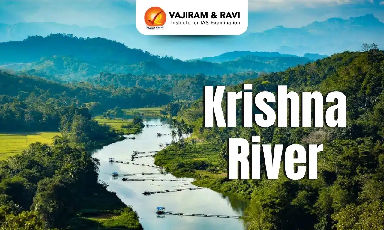
  • The Krishna River, also known as Krishnaveni, is a river of south-central India. 
  • It is India’s fourth-largest river by water inflows and basin area after the Ganga, Godavari, and Brahmaputra
  • It stretches approximately 1400 km. 
  • Course: 
    • The river rises in western Maharashtra state in the Western Ghats range near the town of Mahabaleshwar, not far from the coast of the Arabian Sea. 
    • It passes through the Indian states of Maharashtra, Karnataka, Telangana, and Andhra Pradesh and meets the Bay of Bengal at Hamasaladeevi in Andhra Pradesh on the east coast.
  • The Krishna River Basin extends over an area of about 258,948 sq.km., which is nearly 8 percent of the total geographical area of the country. 
  • It is bounded by the Balaghat range on the north, by the Eastern Ghats on the south and the east, and by the Western Ghats on the west.
  • The principal tributaries joining Krishna are the Ghataprabha, the Malaprabha, the Bhima, the Tungabhadra, and the Musi.
  • The Krishna River and its tributaries create many beautiful waterfalls, such as:
    • Gokak Falls
    • Kalhati Falls
    • Theertham Falls
    • Manikyadhara Falls
    • Hampi Waterfall (formed by the Tungabhadra River)
    • Magod Falls (in the Yellapur taluk of North Canara district)
  • The major dams on the Krishna are the Lal Bahadur Shastri Dam (also known as Almatti Dam), the Nagarjuna Sagar, the Srisailam Dam, the Dhom Dam, the Narayanpur Dam, and the Jurala Dam. 
  • Historically, the Krishna River has been the lifeline for ancient kingdoms such as the Satavahanas and the Vijayanagara Empire. 

News: DH

Krishna River FAQs

Q1: Where does the Krishna River originate?

Ans: Near Mahabaleshwar in the Western Ghats of Maharashtra.

Q2: Into which sea does the Krishna River drain?

Ans: The Bay of Bengal.

Q3: Approximately how long is the Krishna River?

Ans: About 1,400 km.

Q4: Through which four Indian States does the Krishna River flow?

Ans: Maharashtra, Karnataka, Telangana, and Andhra Pradesh.

Sulphur Dioxide

Sulphur Dioxide

Sulphur Dioxide Latest News

Recently, a new analysis showed that most sulphur dioxide around Delhi comes from coal plants which were exempted from pollution rules. 

About Sulphur Dioxide

  • It is an inorganic compound, a heavy, colorless, gas.
  • It is produced in huge quantities in intermediate steps of sulfuric acid manufacture.
  • Properties of Sulphur Dioxide
    • It is a colorless gas with a pungent odor.
    • It is a liquid when under pressure, and it dissolves in water very easily.
  • Applications: It is used to manufacture chemicals, in paper pulping, in metal and food processing.
  • Impacts of Sulphur Dioxide: It is harmful for human health, environment and climate.

Sources of Sulphur Dioxide

  • Burning of Coal: Sulfur dioxide in the air comes mainly from activities such as the burning of coal and oil at power plants or from copper smelting.
  • Industries: It is usually prepared industrially by the burning in air or oxygen of sulfur or such compounds of sulfur as iron pyrite or copper pyrite.
  • Natural Occurrence: In nature, sulfur dioxide can be released to the air from volcanic eruptions.
  • From Fossil Fuel burning: The largest source of SO2 in the atmosphere is the burning of fossil fuels by power plants and other industrial facilities.

Source: DTE 

Sulphur Dioxide FAQs

Q1: What is the chemical formula of Sulphur Dioxide ?

Ans: SO2​

Q2: SO2​ reacts with water to form which acid?

Ans: Sulphurous Acid

Trial in Absentia: Understanding India’s New Legal Mechanism for Absconding Offenders

Trial in Absentia

Trial in Absentia Latest News

  • A Special NIA Court in Jammu has issued a non-bailable warrant against Hafiz Saeed, the Pakistan-based chief of the proscribed terror outfit Lashkar-e-Taiba (LeT), in connection with the investigation into the Pahalgam terror attack. 
  • The warrant was issued at the request of the National Investigation Agency (NIA), two days after it filed a supplementary chargesheet against Saeed. 
  • Since Saeed is unlikely to appear before an Indian court, the NIA is expected to seek a trial in absentia under Section 356 of the Bharatiya Nagarik Suraksha Sanhita (BNSS).

Background of the Case

  • The NIA's supplementary chargesheet has charged Hafiz Saeed both in his individual capacity and as chief of LeT and its proxy outfit, The Resistance Front (TRF). 
  • He has been charged under various provisions of the Bharatiya Nyaya Sanhita (BNS), 2023, and the Unlawful Activities (Prevention) Act, 1967, including provisions relating to waging war against India and conspiracy hatched from across the border.

What is Trial in Absentia?

  • A trial in absentia refers to a criminal trial conducted in the absence of the accused. 
  • Under Section 356 of the BNSS, if a person declared a proclaimed offender has absconded to evade trial and there is no immediate prospect of arrest, the court may treat the accused's absence as a waiver of their right to be present
  • After recording reasons in writing, the court can proceed with the inquiry, trial, and pronouncement of judgment as though the accused were present.

Comparison with the Earlier CrPC Framework

  • Under the Code of Criminal Procedure, 1973 (CrPC), which BNSS has replaced:
    • Section 82(4) CrPC allowed proclamation and attachment of property of an absconding accused.
    • Section 317 CrPC allowed trial in the accused's absence only in specific cases.
    • Section 299 CrPC allowed recording of evidence in the accused's absence if there was no prospect of arrest.
  • These provisions gave presiding officers discretion to proceed in-absentia only if the accused's personal attendance was not necessary for justice, or if the accused persistently disrupted proceedings. 
  • Crucially, none of these provisions allowed a full-fledged trial in absentia, causing many trials to remain pending for years until the accused was apprehended. 
  • BNSS's Section 356 addresses this gap by enabling complete trials, not just partial proceedings, in the accused's absence

Who Does This Apply To?

  • Trial in absentia does not apply to every accused person; it is available only for a "proclaimed offender," as defined under Section 84 of the BNSS
  • Under Section 84(4), if a proclamation has been issued against a person accused of an offence punishable with imprisonment of 10 years or more, life imprisonment, or death, and the person fails to appear before the court, the court may declare them a proclaimed offender after due inquiry.
  • Thus, trial in absentia is restricted to serious offences carrying at least 10 years' imprisonment, life imprisonment, or death, where the accused has already been declared a proclaimed offender.

Procedural Safeguards Under Section 356

  • To protect the accused's right to a fair trial, several safeguards must be met before proceedings can begin:
    • Two consecutive arrest warrants must be issued at an interval of at least 30 days.
    • A public notice must be published in a local or national newspaper, giving the accused 30 days to appear.
    • The notice must be displayed at the accused's last known residence, and a relative or friend must be informed.
    • The trial cannot commence until 90 days have elapsed from the framing of charges, ensuring adequate opportunity for the accused to appear.
    • If the accused has no legal representation, the court must appoint a defence lawyer at State expense.
    • Statements of prosecution witnesses recorded before the trial may be used as evidence; however, if the accused is later apprehended, the court may permit cross-examination of witnesses in the interest of justice.
    • Depositions and witness examinations may be recorded through audiovisual electronic means, preserved to ensure transparency, accuracy, and integrity, and to enable review if the accused is later apprehended.

Conclusion

  • Trial in absentia under BNSS marks a significant shift from the CrPC's fragmented approach, enabling complete trials of proclaimed offenders in serious cases while embedding robust safeguards. 
  • It balances the need for timely justice against absconding offenders like Hafiz Saeed with the constitutional guarantee of a fair trial.

Source: TH | OHRH

Trial in Absentia FAQs

Q1: What is Trial in Absentia under the BNSS?

Ans: Trial in Absentia allows courts to conduct criminal proceedings against proclaimed offenders who deliberately evade arrest, subject to strict procedural safeguards and judicial oversight.

Q2: Who can be subjected to Trial in Absentia?

Ans: Trial in Absentia applies only to proclaimed offenders accused of serious offences punishable with at least ten years' imprisonment, life imprisonment or death.

Q3: What safeguards are provided before commencing a Trial in Absentia?

Ans: Trial in Absentia requires arrest warrants, public notice, adequate opportunity to appear, legal representation and judicial satisfaction before proceedings can begin.

Q4: How does Trial in Absentia differ from the earlier CrPC framework?

Ans: Unlike the CrPC, Trial in Absentia under the BNSS permits a complete criminal trial against absconding proclaimed offenders instead of only limited proceedings.

Q5: Why is Trial in Absentia significant for India's criminal justice system?

Ans: Trial in Absentia balances speedy justice with fair trial guarantees, preventing proclaimed offenders from indefinitely delaying criminal proceedings through deliberate absconding.

Strait of Hormuz Transit Fee: Why Trump’s 20% Proposal Was Never Workable

Strait of Hormuz Transit Fee

Strait of Hormuz Transit Fee Latest News

  • US President Donald Trump has reversed his plan to charge a 20% fee on commercial vessels transiting the Strait of Hormuz, just a day after announcing it. 
  • He announced to replace the 20% United States Reimbursement Fee with Trade and Investment Deals. The abrupt reversal came amid widespread scepticism from experts over the plan's legality and feasibility.

The Original Proposal and Its Flaws

  • Trump had announced that the US would become "THE GUARDIAN OF THE HORMUZ STRAIT" and, as a matter of fairness, be reimbursed at 20% on all cargo shipped to cover the costs of providing security in the region. 
  • However, the proposal left several critical questions unanswered:
    • Calculation ambiguity: It was unclear whether the fee would apply to the total value of cargo, the cost incurred by American forces, or some other formula.
    • Cost impact: If based on total cargo value, shipping costs through the strait would have risen sharply, significantly increasing the landed price of commodities.
    • Implementation and legality: Questions arose over how the fee would be enforced and its legality under international law.
    • Security guarantee: The US's ability to guarantee safety of commercial vessels was doubtful, given its response to Iranian strikes had so far been only retaliatory, without pre-emptive protective measures.

International Opposition

  • The International Maritime Organization (IMO) firmly opposed the plan, stating there is no legal basis to impose mandatory tolls for transiting straits used for international navigation. 
  • Notably, the US has traditionally championed freedom of navigation and had strongly opposed Iran's attempts to charge tolls for the same strait, making Trump's proposal a reversal of Washington's own long-held position.
  • Also, this could have inadvertently strengthened Iran's case for imposing its own tolls.

The Underlying Battle for Control of Hormuz


  • The fee flip-flop reflects a deeper contest between the US and Iran over control of the strategically vital waterway:
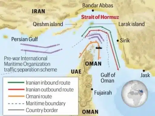
    • An interim US-Iran pact signed on June 17, 2026 had promised to reopen the Strait of Hormuz, and vessel transits rose meaningfully thereafter, though still below pre-war levels of up to 140 daily transits.
    • Renewed tensions caused vessel transits to crash to their lowest levels in nearly a month.
    • Iran's Foreign Minister asserted that Iran, not the US, has "always been the GUARDIAN of the Strait," while also calling Trump's 20% figure excessive.
  • Since the war began in February 2026, Iran has claimed sovereignty over parts of the strait and targeted vessels sailing outside its authorised shipping lanes, while the US has struck Iranian military targets in response.
  • Iran closed the strait to commercial vessels over the preceding weekend, prompting the US to reinstate a naval blockade in the region.
  • Under UNCLOS, straits are natural waterways with no general transit charge, though neither the US nor Iran has ratified this convention; it is nonetheless widely accepted as customary international law.

Why This Mattered for India

  • Had the fee been implemented, it would have significantly impacted India as a major energy importer:
    • India sources around 40% of its crude oil, 60% of its LNG, and 90% of its LPG imports from West Asia via the Strait of Hormuz.
      • India's import dependence stands at over 88% for oil, 60% for LPG, and about 50% for natural gas.
    • A 20% fee on a $75/barrel crude oil price would have pushed the landed cost to over $90/barrel.
    • Assuming 30% of India's oil imports continued via Hormuz, the fee alone could have added $9 billion annually to India's oil import bill, excluding additional costs for LNG, LPG, fertilisers, and industrial inputs.
    • Every $1/barrel rise in oil prices increases India's annual oil import bill by up to $2 billion, given India imports 1.8-2 billion barrels of crude annually.

India's Broader Response to the Crisis

  • India has consistently advocated that navigation through international waterways like the Strait of Hormuz should remain free and accessible to all.
  • Diversified crude sourcing helped maintain adequate oil supplies, but the government had to ration gas supplies to certain industries and take emergency measures to prevent panic fuel buying; some of these were rolled back after the June MoU improved the situation.
  • India's oil imports surged 47% year-on-year to $48.88 billion in March-May 2026, as the country prioritised supply security over cost, as per Ministry of Petroleum and Natural Gas data.
  • Elevated energy import costs have wider ramifications for India's trade balance, current account, inflation, and the rupee's exchange rate.

Conclusion

  • Trump's rapid U-turn exposed the impracticality of unilaterally taxing a strategic international waterway, legally, diplomatically, and economically. 
  • For India, it underscores continued vulnerability to West Asian energy disruptions, reinforcing the need for diversified sourcing and sustained advocacy for free global navigation.

Source: IE

Strait of Hormuz Transit Fee FAQs

Q1: Why was the proposed Strait of Hormuz Transit Fee considered unworkable?

Ans: The Strait of Hormuz Transit Fee lacked legal backing, faced implementation challenges and contradicted internationally accepted principles governing navigation through strategic international waterways.

Q2: How would the Strait of Hormuz Transit Fee have affected India?

Ans: The Strait of Hormuz Transit Fee would have increased India's energy import costs, fuel inflation and trade deficit due to the country's heavy dependence on West Asian energy supplies.

Q3: Why did the International Maritime Organization oppose the Strait of Hormuz Transit Fee?

Ans: The International Maritime Organization argued that the Strait of Hormuz Transit Fee had no legal basis because international straits generally cannot be subjected to mandatory transit charges.

Q4: What broader geopolitical issue does the Strait of Hormuz Transit Fee debate reflect?

Ans: The Strait of Hormuz Transit Fee controversy reflects the strategic rivalry between the United States and Iran over security, navigation and influence in a critical global energy chokepoint.

Q5: What lessons does the Strait of Hormuz Transit Fee episode offer for India?

Ans: The Strait of Hormuz Transit Fee episode underscores the need for diversified energy imports, strategic reserves, resilient supply chains and continued support for freedom of navigation.

Valmiki Tiger Reserve

Valmiki Tiger Reserve (VTR)

Valmiki Tiger Reserve Latest News

The Valmiki Tiger Reserve (VTR) in West Champaran is emerging as one of the state’s richest reptile habitats with more than 45 species of snakes recorded in its forests. 

About Valmiki Tiger Reserve

  • Location: It is located at the India-Nepal border in the northern part of the West Champaran District of Bihar. 
  • It forms the easternmost limit of the Himalayan Terai forests in India and is the only tiger reserve of Bihar.
  • It comprises the Valmiki National Park and the Valmiki Wild Sanctuary.
    • It is Situated in the Gangetic Plains bio-geographic zone of the country, the forest has a combination of Bhabar and Terai tracts.
  • Bordered by: It is surrounded by the Royal Chitwan National Park of Nepal in the north and the river Gandak on the western side.
  • Rivers: The Rivers Gandak, Pandai, Manor, Harha, Masan, and Bhapsa flow through various parts of the reserve.
  • Vegetation: The reserve boasts a variety of vegetation types, including tropical wet deciduous forests, grasslands, savannas, and riverine forests. 
  • Flora: Sal trees dominate the forests, but the region also features species like teak, bamboo, semal, and khair.
  • Fauna: Tiger, leopard, fishing cat, leopard cat, sambar, hog deer, spotted deer, black buck, gaur, sloth bear, langur, rhesus monkey, etc.

Source: TOI

Valmiki Tiger Reserve FAQs

Q1: Valmiki Tiger Reserve is located in which state?

Ans: Bihar

Q2: Valmiki TR shares its border with which country?

Ans: Nepal

Draft National Health Research Policy 2026 – Explained

Health Research Policy

Health Research Policy Latest News

  • The Centre has released the Draft National Health Research Policy 2026, proposing a comprehensive overhaul of India's health research ecosystem to align research more closely with the country's disease burden and public health priorities.

About Health Research in India

  • Health research in India is a broad field encompassing biomedical science, clinical medicine, public health, epidemiology, digital health, health systems, behavioural sciences, and emerging technologies. It plays a critical role in:
    • Understanding disease patterns and burden
    • Developing vaccines, diagnostics, and medicines
    • Informing evidence-based policymaking
    • Improving healthcare delivery
    • Preparing for public health emergencies

Key Institutions

  • India has built considerable scientific capability through institutions such as:
    • Indian Council of Medical Research (ICMR)
    • Department of Health Research (DHR)
    • All India Institute of Medical Sciences (AIIMS) and other premier institutions
    • National Institute of Nutrition (NIN), Hyderabad

Existing Framework

  • The current National Health Research Policy was introduced in 2011. The new draft policy aims to update this framework to address emerging challenges and align with India's growing ambitions in health research.
  • Low Public Investment
    • India currently spends only 0.024% of GDP on health research.
    • This is significantly below the weighted average of 0.27% of GDP invested by high-income countries (as reported by WHO).
  • Uneven Research Capacity
    • Research capacity is concentrated in a handful of institutions and states.
    • Wide regional disparities exist in research infrastructure and capabilities.
    • Many medical colleges have limited research output.
  • Fragmented Research Efforts
    • Duplication of research by different agencies.
    • Lack of coordination between academia, hospitals, industry, and government.
    • Absence of a unified national framework.
  • Priorities Not Aligned with Disease Burden
    • Research priorities do not always match India's real disease burden.
    • Insufficient focus on equity concerns and health system gaps.
    • Inadequate preparation for future public health emergencies.
  • Slow Translation of Research
    • Scientific findings often do not translate into healthcare delivery.
    • Administrative and regulatory delays slow down research.
    • Weak links between research outcomes and policy implementation.
  • Limited Cross-Sector Collaboration
    • Weak collaboration between academia, hospitals, industry, and government.
    • Limited participation of the private sector in health research.
    • Insufficient community engagement in research priorities.

News Summary: Draft National Health Research Policy 2026

  • The Department of Health Research has released the Draft National Health Research Policy 2026, which represents the first attempt at a unified national framework spanning all areas of health research. 
  • The policy has been opened for public comments until 27 July, after which it will be finalised.
  • The draft policy aims to:
    • Align scientific research more closely with disease burden and public health priorities
    • Promote indigenous innovation
    • Enable evidence-based policymaking
    • Ensure measurable outcomes
    • Address fragmentation and regional disparities
    • Speed up translation of research into healthcare and policy

Key Proposals of the Draft Policy

  • Massive Increase in Research Funding
    • The draft proposes a six-fold increase in government spending on health research:
    • Current: 0.024% of GDP
    • By 2037: 0.072% of GDP
    • By 2047: 0.15% of GDP
    • While this would bring India closer to high-income countries' investment levels, it would still remain below their current weighted average of 0.27%.
  • National Health Research Agenda
    • A National Health Research Agenda will be created to identify priority research areas based on:
      • Disease burden in India
      • Emerging health threats
      • Health system needs
      • National priorities
      • Equity and pandemic preparedness
      • Strategic national interest
  • Priority Research Areas
    • The draft identifies key priority areas including: Tuberculosis, Antimicrobial resistance (AMR), Vector-borne diseases, Cancer, Non-communicable diseases (NCDs), Mental health, Anaemia, Child malnutrition, Women's health, Maternal and neonatal mortality, Primary healthcare and Emergency care
  • Three-Tier Governance Structure
    • The draft proposes a comprehensive three-tier governance structure:
    • National Health Research Stewardship Committee - for overall strategic coordination.
    • Department of Health Research - as the nodal implementing agency.
    • Indian Council of Medical Research (ICMR) - as the scientific and technical lead.
    • States will be expected to weave research more tightly into local health programmes and service delivery.
  • New Evaluation Framework for Scientists
    • A significant shift is proposed in how researchers are evaluated:
    • Moving from counting research papers and grants to assessing real-world impact.
    • Expanded use of the ICMR Impact of Research and Innovation Scale (ICMR-IRIS) introduced in 2025.
    • As the draft states: "It is not enough to count studies completed, papers published, grants awarded, or technologies developed. The deeper test is whether research strengthens scientific capability, informs policy and practice, builds institutions and people, reaches underserved populations, improves health systems, and contributes to better health for India and the world."
  • Simplified Ethics and Regulatory Framework
    • Simplified ethics approvals for multicentre studies.
    • Establishment of a National Research Integrity Office (NRIO).
    • Responsible use of artificial intelligence in health research.
    • Expanded shared access to laboratories, biobanks, and other publicly funded research facilities.
  • Bigger Role for States and Private Sector
    • The policy seeks to expand health research beyond a few leading institutions by:
    • Strengthening research capacity in medical colleges.
    • Encouraging greater participation from private hospitals, startups, and industry.
    • Improving collaboration between researchers, policymakers, and healthcare providers.
    • Requiring states to prepare their own health research agendas based on local disease patterns.
    • Calling for greater investment from industry, philanthropic organisations, and CSR initiatives.

Expert Views

  • According to experts in global health and bioethics, the draft is a step towards making health research more responsive to the country's needs:
  • The draft covers the entire research pathway from identifying priorities to generating evidence, innovation, implementation, and measuring real-world impact.
  • It places ethical and scientific integrity, community participation, and accountability at the centre.
  • The proposal to expand research beyond a few institutions and involve states in setting priorities is welcome.
  • However, the policy's goals will require sustained investment and effective implementation.
  • It should help address challenges such as inadequate research infrastructure, research misconduct, delays in fellowship payments to research scholars, and timely implementation.

Source: TH | Print

Health Research Policy FAQs

Q1: Which department released the Draft National Health Research Policy 2026?

Ans: The Department of Health Research under the Ministry of Health and Family Welfare released the draft policy.

Q2: What is India's current spending on health research as a percentage of GDP?

Ans: India currently spends 0.024% of its GDP on health research, well below the average of 0.27% in high-income countries.

Q3: What are the target spending levels proposed by the draft policy?

Ans: The draft proposes increasing health research spending to 0.072% of GDP by 2037 and 0.15% of GDP by 2047.

Q4: What is the three-tier governance structure proposed in the policy?

Ans: It comprises the National Health Research Stewardship Committee for strategic coordination, the Department of Health Research as nodal implementing agency, and ICMR as the scientific and technical lead.

Q5: What is the ICMR Impact of Research and Innovation Scale (ICMR-IRIS)?

Ans: ICMR-IRIS is a framework introduced by ICMR in 2025 to assess research impact beyond publications, including contributions to clinical guidelines, public health programmes, and health outcomes.

Indian Grey Hornbill

Indian Grey hornbill

Indian Grey Hornbill Latest News

Gujarat has added another landmark achievement to its growing conservation story with the successful return of the Indian Grey Hornbill to the Gir forests after an absence of more than 60 years. 

About Indian Grey Hornbill

  • The Indian gray hornbill (Ocyceros birostris) is a tropical bird that can be found on the Indian subcontinent.
  • It is commonly sighted in pairs.
  • These birds are known to be arboreal, i.e. spend most of their time on tall trees, but may descend for food and to collect mud pellets for nesting. 
  • Appearance
    • It has grey feathers all over the body with a light grey or dull white belly.
    • The horn is black or dark grey with a casque extending to the point of curvature of the horn.
    • Unlike a lot of other birds, the male and female look similar.
  • Habitat: It is mainly found in deciduous forests, open woodlands and thorn forest as well as rural cultivation and urban gardens and parks.
  • Distribution: Indian subcontinent; found from north-east Pakistan and south Nepal east to north-west Bangladesh and south throughout most of India except in Assam.
  • Behaviour: They have various social activities, including bill-grappling and aerial jousting. Indian grey hornbills are quite noisy producing squealing calls.
  • Diet: The food is mainly fruits, particularly figs.
  • Ecological Role: They play an essential role in the ecosystem as prime dispersers of seeds, helping regenerate forests by transporting seeds of fruit-bearing trees across large areas.
  • Conservation status: IUCN: Least Concern.

Source: TH

Indian Grey Hornbill FAQs

Q1: Indian Grey Hornbill is found in which type of habitat?

Ans: Dry deciduous forests, urban areas and gardens

Q2: Indian Grey Hornbill is native to which country?

Ans: India and Nepal

Countries and Currencies in the World, List, Importance

Countries and Currencies

The World consists of 195 countries and each country has its own currency. Having a knowledge of countries, capitals and currencies is important to get an understanding of the global world. In this article, we are going to cover the list of countries and their currencies. 

Why are Countries and Currencies Important?

The currency of a country works as a legal tender for the transactions and represents the economic structure and financial stability of a country. A country and its currencies are important because: 

  • Helps in understanding international travel and trade
  • Study global economics and travel
  • Conduct cross-border business transactions

Currency of a Country

A currency of a country consists of papers and coins that act as a medium of exchange, store of value and unit of account. While many countries use the same currency, many countries have their own unique currency. These currencies keep fluctuating on the basis of inflation, demand and economic performance.

Also Read: Countries and Capitals

Countries and their Currencies 

Countries and their currencies help in understanding the geopolitical dynamics regionally. Here is a list of countries and their currencies:  

Countries and Currencies of Africa 

Africa is the second largest continent of the world in both area and its population. The continent consists of 54 recognised nations, each having its own capital and currency and a rich diversity of culture, language and economic system. 

Countries And Currencies of Africa
Country Currency

Algeria

Algerian Dinar

Angola

Angolan Kwanza

Benin

West African CFA franc

Botswana

Botswana Pula

Burkina Faso

West African CFA franc

Burundi

Burundian Franc

Cabo Verde

Cape Verdean Escudo

Cameroon

Central African CFA franc

Central African Rep.

Central African CFA franc

Chad

Central African CFA franc

Comoros

Comorian Franc

Congo (Brazzaville)

Central African CFA franc

Congo (Kinshasa)

Congolese Franc

Côte d’Ivoire

West African CFA franc

Djibouti

Djiboutian Franc

Egypt

Egyptian Pound

Equatorial Guinea

Central African CFA franc

Eritrea

Eritrean Nakfa

Eswatini

Swazi Lilangeni

Ethiopia

Ethiopian Birr

Gabon

Central African CFA franc

Gambia

Gambian Dalasi

Ghana

Ghanaian Cedi

Guinea

Guinean Franc

Guinea-Bissau

West African CFA franc

Kenya

Kenyan Shilling

Lesotho

Lesotho Loti

Liberia

Liberian Dollar

Libya

Libyan Dinar

Madagascar

Malagasy Ariary

Malawi

Malawian Kwacha

Mali

West African CFA franc

Mauritania

Mauritanian Ouguiya

Mauritius

Mauritian Rupee

Morocco

Moroccan Dirham

Mozambique

Mozambican Metical

Namibia

Namibian Dollar

Niger

West African CFA franc

Nigeria

Nigerian Naira

Rwanda

Rwandan Franc

São Tomé & Príncipe

Dobra

Senegal

West African CFA franc

Seychelles

Seychellois Rupee

Sierra Leone

Sierra Leonean Leone

Somalia

Somali Shilling

South Africa

South African Rand

South Sudan

South Sudanese Pound

Sudan

Sudanese Pound

Tanzania

Tanzanian Shilling

Togo

West African CFA franc

Tunisia

Tunisian Dinar

Uganda

Ugandan Shilling

Zambia

Zambian Kwacha

Zimbabwe

Zimbabwean Dollar

Countries And Currencies of North America 

North America has 23 countries including the United States, Canada and Mexico. Following is the list of countries and currencies of North America: 

Countries, Capitals And Currencies of North America
Country Currency

Antigua and Barbuda

East Caribbean Dollar

Bahamas

Bahamian Dollar

Barbados

Barbadian Dollar

Belize

Belize Dollar

Canada

Canadian Dollar

Costa Rica

Costa Rican Colón

Cuba

Cuban Peso

Dominica

East Caribbean Dollar

Dominican Republic

Dominican Peso

El Salvador

United States Dollar

Grenada

East Caribbean Dollar

Guatemala

Guatemalan Quetzal

Haiti

Haitian Gourde

Honduras

Honduran Lempira

Jamaica

Jamaican Dollar

Mexico

Mexican Peso

Nicaragua

Nicaraguan Córdoba

Panama

Balboa / USD

Saint Kitts & Nevis

East Caribbean Dollar

Saint Lucia

East Caribbean Dollar

Saint Vincent & Gren.

East Caribbean Dollar

Trinidad and Tobago

Trinidadian Dollar

United States

United States Dollar

Countries, Capitals And Currencies of South America

South America has 12 countries having their unique identities. Here is a list of South American Countries and their currencies: 

Countries, Capitals And Currencies of South America
Country Currency

Argentina

Argentine Peso

Bolivia

Boliviano

Brazil

Brazilian Real

Chile

Chilean Peso

Colombia

Colombian Peso

Ecuador

United States Dollar

Guyana

Guyanese Dollar

Paraguay

Paraguayan Guaraní

Peru

Peruvian Sol

Suriname

Surinamese Dollar

Uruguay

Uruguayan Peso

Venezuela

Venezuelan Bolívar

Countries And Currencies of Asia 

Asia is the largest and the most populous continent. Here is a list of countries and currencies of Asia: 

Countries, Capitals And Currencies of Asia
Country Currency

Afghanistan

Afghani

Armenia

Armenian Dram

Azerbaijan

Azerbaijani Manat

Bahrain

Bahraini Dinar

Bangladesh

Bangladeshi Taka

Bhutan

Bhutanese Ngultrum

Brunei

Brunei Dollar

Cambodia

Cambodian Riel

China

Chinese Yuan

Cyprus

Euro

Georgia

Georgian Lari

India

Indian Rupee

Indonesia

Indonesian Rupiah

Iran

Iranian Rial

Iraq

Iraqi Dinar

Israel

Israeli Shekel

Japan

Japanese Yen

Jordan

Jordanian Dinar

Kazakhstan

Kazakhstani Tenge

Kuwait

Kuwaiti Dinar

Kyrgyzstan

Kyrgyzstani Som

Laos

Lao Kip

Lebanon

Lebanese Pound

Malaysia

Malaysian Ringgit

Maldives

Maldivian Rufiyaa

Mongolia

Mongolian Tögrög

Myanmar

Burmese Kyat

Nepal

Nepalese Rupee

North Korea

North Korean Won

Oman

Omani Rial

Pakistan

Pakistani Rupee

Palestine

Israeli Shekel

Philippines

Philippine Peso

Qatar

Qatari Riyal

Russia

Russian Ruble

Saudi Arabia

Saudi Riyal

Singapore

Singapore Dollar

South Korea

South Korean Won

Sri Lanka

Sri Lankan Rupee

Syria

Syrian Pound

Taiwan

New Taiwan Dollar

Tajikistan

Tajikistani Somoni

Thailand

Thai Baht

Timor-Leste

United States Dollar

Turkey

Turkish Lira

Turkmenistan

Turkmenistani Manat

United Arab Emirates

UAE Dirham

Uzbekistan

Uzbekistani Som

Vietnam

Vietnamese Dong

Yemen

Yemeni Rial

Countries And Currencies of Europe 

Europe has 44 countries and a maximum of them use Euro as their currency. Here is a list of countries and their currencies in Europe: 

Countries And Currencies of Europe
Country Currency

Albania

Albanian Lek

Andorra

Euro

Austria

Euro

Belarus

Belarusian Ruble

Belgium

Euro

Bosnia & Herzegovina

Convertible Mark

Bulgaria

Bulgarian Lev

Croatia

Euro

Cyprus

Euro

Czech Republic

Czech Koruna

Denmark

Danish Krone

Estonia

Euro

Finland

Euro

France

Euro

Germany

Euro

Greece

Euro

Hungary

Hungarian Forint

Iceland

Icelandic Krona

Ireland

Euro

Italy

Euro

Kosovo

Euro

Latvia

Euro

Liechtenstein

Swiss Franc

Lithuania

Euro

Luxembourg

Euro

Malta

Euro

Moldova

Moldovan Leu

Monaco

Euro

Montenegro

Euro

Netherlands

Euro

North Macedonia

Macedonian Denar

Norway

Norwegian Krone

Poland

Polish Złoty

Portugal

Euro

Romania

Romanian Leu

Russia

Russian Ruble

San Marino

Euro

Serbia

Serbian Dinar

Slovakia

Euro

Slovenia

Euro

Spain

Euro

Sweden

Swedish Krona

Switzerland

Swiss Franc

Ukraine

Ukrainian Hryvnia

United Kingdom

Pound Sterling

Vatican City

Euro

Countries And Currencies of Australia & Oceania

Oceania that also includes Australia consists of many scattered islands over the Pacific Ocean. Here is a list of countries and their currencies in Australia and Oceania: 

Countries And Currencies of Australia & Oceania
Country Currency

Australia

Australian Dollar

Fiji

Fijian Dollar

Kiribati

Australian Dollar

Marshall Islands

United States Dollar

Micronesia

United States Dollar

Nauru

Australian Dollar

New Zealand

New Zealand Dollar

Palau

United States Dollar

Papua New Guinea

Papua New Guinean Kina

Samoa

Samoan Tala

Solomon Islands

Solomon Islands Dollar

Tonga

Tongan Paʻanga

Tuvalu

Australian Dollar

Vanuatu

Vanuatu Vatu

Countries and Currencies FAQs

Q1: How many countries are there in Europe?

Ans: There are 44 countries in Europe.

Q2: Why do countries have separate currencies?

Ans: Countries have separate currencies to maintain independent monetary policies and economic control.

Q3: Which is the most powerful currency in the world?

Ans: The Kuwaiti Dinar (KWD) is considered the most powerful currency in the world.

Q4: Pound is the currency of which country?

Ans: The Pound is the official currency of the United Kingdom.

Q5: What is the currency of Japan?

Ans: The official currency of Japan is the Japanese Yen (JPY).

Daily Editorial Analysis 15 July 2026

Daily-Editorial-Analysis

India-U.S. Defence Technology Ties — Big Ambitions, Little Delivery

Context

  • India–United States defence cooperation has expanded significantly over the past two decades, reflecting growing strategic convergence in the Indo-Pacific.
  • While bilateral defence trade, military exercises, and interoperability have strengthened considerably, the industrial dimension of the partnership has lagged behind.
  • Successive initiatives have promised co-development, co-production, and technology transfer, yet most have been hindered by export controls, intellectual property disputes, and differing commercial priorities.
  • As a result, the relationship has evolved into a strong procurement partnership but has fallen short of becoming a robust defence-industrial collaboration.

Evolution of India–U.S. Defence Cooperation the Case of the GE Engine

  • Evolution of India–U.S. Defence Cooperation
    • Since 2002, India has procured over $22 billion worth of U.S. defence equipment, including Apache and Chinook helicopters, C-17 and C-130J transport aircraft, P-8I maritime patrol aircraft, and M777 howitzers.
    • These acquisitions have enhanced India's military capabilities and established the United States as a major defence supplier.
    • However, meaningful technology transfer and domestic manufacturing have remained limited, keeping the relationship largely transactional.
  • The Case of the GE Engine
    • The GE F414 fighter engine programme best illustrates the gap between political ambition and industrial reality.
    • Announced during Prime Minister Narendra Modi's 2023 visit to Washington under the Initiative on Critical and Emerging Technologies (iCET), it was projected as a landmark project for defence-industrial cooperation.
    • However, negotiations have faced significant hurdles. The estimated cost of each engine reportedly increased from ₹70–80 crore to over ₹200 crore, while General Electric sought nearly $800 million in Indian investment to establish a production line.
    • Differences over technology transfer, intellectual property, and licensed manufacturing have complicated negotiations involving Hindustan Aeronautics Limited (HAL), the Defence Research and Development Organisation (DRDO), and the Aeronautical Development Agency (ADA) for the Tejas Mk-II, Advanced Medium Combat Aircraft (AMCA), and the Navy's Twin-Engine Deck-Based Fighter.
    • The programme has consequently become a symbol of the persistent implementation gap.

Vision, Stagnation & Other Challenges in US-India Defence Ties

  • Defence Technology and Trade Initiative (DTTI)
    • Launched in 2012, the Defence Technology and Trade Initiative (DTTI) aimed to promote joint development and production of defence technologies.
    • Despite extensive consultations, it produced few tangible outcomes and gradually lost momentum.
  • Initiative on Critical and Emerging Technologies (iCET)
    • Introduced in 2022, iCET expanded cooperation to artificial intelligence, quantum technologies, semiconductors, biotechnology, telecommunications, drones, and resilient supply chains.
    • Nevertheless, several flagship defence projects, including the F414 engine programme, continue to face implementation challenges.
  • India–United States Defence Acceleration Ecosystem (INDUS-X)
    • The India–United States Defence Acceleration Ecosystem (INDUS-X), launched in 2023 to connect defence start-ups, academia, and industry, has yet to produce significant co-development outcomes.
  • Other Stalled Defence Projects
    • Several other initiatives have followed a similar trajectory. Proposed collaboration on the Javelin anti-tank guided missile and the Stryker infantry combat vehicle has remained unresolved for years.
    • Likewise, India's acquisition of 31 MQ-9B SkyGuardian and SeaGuardian remotely piloted aircraft through the Foreign Military Sales (FMS) route has largely remained a procurement deal, while promised local assembly, manufacturing, and maintenance infrastructure are yet to materialise.
  • The Technology Transfer Divide
    • The core challenge lies in the contrasting approaches of both countries.
    • India views defence partnerships as instruments for strengthening indigenous manufacturing, building domestic technological capabilities, and advancing Atmanirbhar Bharat.
    • In contrast, the United States considers advanced defence technologies strategic assets protected under the International Traffic in Arms Regulations (ITAR), which impose strict restrictions on transferring sensitive technologies and manufacturing expertise.
    • The F414 negotiations clearly reflect this divergence. India seeks access to manufacturing know-how and critical technologies to develop long-term domestic capabilities, whereas the United States prioritises security concerns and export-control obligations.
    • Consequently, cooperation has expanded in defence procurement and military interoperability but remains limited in industrial capability creation.

Future Prospects

  • The proposed Reciprocal Defence Procurement Agreement (RDPA) represents the next major opportunity to deepen industrial cooperation by granting reciprocal access to defence procurement markets.
  • However, India's developing defence industry could face intense competition from larger and technologically superior American firms.
  • Without adequate safeguards, such reciprocity may reinforce existing asymmetries instead of fostering balanced industrial collaboration.

Conclusion

  • India–United States defence cooperation has made remarkable progress in strategic partnership, defence trade, military exercises, and logistics cooperation.
  • However, initiatives such as DTTI, iCET, INDUS-X, and the GE F414 programme demonstrate that political ambition has not yet translated into meaningful industrial outcomes.
  • Bridging this gap requires greater policy alignment, mutual trust, and mechanisms that balance India's objective of self-reliance with U.S. security and export-control concerns.
  • Only then can the partnership evolve from a buyer-seller relationship into a genuine defence-industrial alliance capable of supporting long-term strategic objectives.

India-U.S. Defence Technology Ties — Big Ambitions, Little Delivery FAQs

Q1. What is the main challenge in India–U.S. defence cooperation?
Ans. The main challenge is translating political commitments into meaningful industrial cooperation.

Q2. Why is the GE F414 engine programme significant?
Ans. It highlights the difficulties in technology transfer, cost negotiations, and defence manufacturing.

Q3. What was the objective of the Defence Technology and Trade Initiative (DTTI)?
Ans. The DTTI aimed to promote defence co-development and co-production between India and the United States.

Q4. Why does technology transfer remain limited in India–U.S. defence ties?
Ans. U.S. export-control regulations and security concerns restrict the transfer of sensitive defence technologies.

Q5. What is the purpose of the proposed Reciprocal Defence Procurement Agreement (RDPA)?
Ans. The RDPA seeks to provide reciprocal access to defence procurement markets in both countries.

Source: The Hindu


Road Safety as a Constitutional Imperative - Reforming India's Fragmented Governance

Context

  • India recorded the world's highest number of road accident deaths in 2024, with official agencies reporting 1.75–1.81 lakh fatalities through different methodologies.
  • The road accidents are preventable governance failures, not unavoidable tragedies, and calls for constitutional and institutional reforms to establish clear accountability for road safety.

India's Road Safety Crisis

  • Official data presents conflicting estimates: For example,
    • The Ministry of Road Transport and Highways (MoRTH) shows that 1.77 lakh people lost their lives in road crashes.
    • National Crime Records Bureau (NCRB) – Accidental Deaths and Suicides Report: 1.75 lakh deaths.
    • NCRB – Crime in India Report: 1.81 lakh deaths.
  • The discrepancy of nearly 6,000 deaths reflects multiple reporting systems and methodologies, highlighting weaknesses in governance rather than merely statistical inconsistencies.
  • Despite having a smaller share of the world's vehicles, India records the highest number of road fatalities globally, indicating systemic deficiencies.

Supreme Court's Constitutional Perspective 

  • Rajaseekaran v. Union of India (2014):
    • The Supreme Court examined road safety through the four Es -
      • Engineering: Poor road design and inadequate highway maintenance, receiving only 35–40% of the required funding.
      • Enforcement: Weak and inconsistent implementation of traffic laws.
      • Education: Limited public awareness and poor road safety culture.
      • Emergency care: Insufficient ambulances, lack of trauma centres, and delays caused by jurisdictional disputes among authorities.
  • Road safety and Article 21:
    • The Court held that road accidents are preventable, resulting primarily from human and institutional failures rather than fate.
    • Since preventable deaths violate the Right to Life under Article 21, failure to create an effective road safety framework amounts to a constitutional failure of governance.

Constitutional Fragmentation - The Core Governance Challenge:

  • India's constitutional distribution of powers fragments responsibility across multiple levels.
  • For instance, in the Seventh Schedule of the Constitution -
    • National Highways falls in the Union List.
    • State roads and Police – State List.
    • Motor vehicles – Concurrent List.
    • Public health – State List.
  • Implications of this fragmentation:
    • Road crashes simultaneously involve several constitutional entries without an integrated authority.
    • As multiple agencies share responsibility, no institution is solely accountable for preventing future accidents.
    • Existing responses—committees, advisories and proposed boards—lack statutory authority and effective coordination.

Need for Constitutional and Institutional Reform

  • Road Safety Coordination Council:
    • Establish a constitutional body on the lines of the GST Council created through the 101st Constitutional Amendment Act.
    • The Council should facilitate cooperative federalism by enabling the Centre and States to jointly frame -
      • Road engineering standards.
      • Vehicle fitness norms.
      • Traffic enforcement protocols.
      • Emergency medical response.
      • Uniform fatality reporting systems.
  • Amend the Seventh Schedule:
    • Reallocate legislative powers to provide Parliament greater authority over road safety and traffic regulation. Reduce jurisdictional overlaps and strengthen national accountability.
  • Statutory District Road Safety Committees:
    • Parliament should enact legislation providing -
    • Clearly defined powers and responsibilities.
    • Regular monitoring and compliance mechanisms.
    • Accountability measures and consequences for States that fail to implement road safety norms effectively.

Why Existing Approaches Have Fallen Short:

  • Numerous advisory committees have been constituted over the years, but they lack constitutional backing, binding decision-making powers, and institutional accountability.
  • The judiciary has repeatedly intervened because executive and legislative responses have remained fragmented and inadequate.
  • Sustainable improvement requires structural constitutional reform, not periodic judicial intervention.

Conclusion:

  • India's road safety crisis is fundamentally a governance and constitutional challenge, not merely a transport issue.
  • Preventable road deaths represent a failure to protect the Right to Life under Article 21.
  • India needs constitutional and institutional reforms (on the lines of the GST Council) to create a coherent, nationwide road safety framework capable of significantly reducing preventable fatalities.

Road Safety as a Constitutional Imperative FAQs

Q1. How does Article 21 of the Constitution relate to road safety?

Ans. Preventable road accident deaths violate the Right to Life under Article 21.

Q2. Why is India's road safety governance considered fragmented?

Ans. Responsibility is divided among the Union, States and Concurrent List subjects, resulting in weak coordination.

Q3. What are the 'Four Es' of road safety highlighted by the Supreme Court?

Ans. Engineering, Enforcement, Education and Emergency Care (S. Rajaseekaran v. Union of India (2014)).

Q4. Why is a Road Safety Coordination Council modelled after the GST Council being proposed?

Ans. To institutionalise cooperative federalism and enable uniform policymaking, coordination and accountability.

Q5. What constitutional reforms are suggested to strengthen road safety governance in India?

Ans. Amendment of the Seventh Schedule, statutory District Road Safety Committees with defined powers and accountability, etc.

Source: IE


The Dangers of Being a Cool Teacher

Context

  • A new kind of teacher has emerged in 2026, one celebrated by parents and students for explaining lessons through trending audio, going live on Instagram at night for "real talk," and replying to student DMs.
  • While the intent behind such behaviour is often warm, being a "cool teacher" increasingly means becoming a content creator.
  • This shift from educator to influencer is quietly eroding a crucial structure in a child's life: the boundary between adult and child.
  • This article highlights the emerging challenges posed by the growing trend of teachers becoming social media influencers.

The Legal Architecture Around Teacher-Student Relationships

  • India's legal framework around teacher-student interactions is not accidental:
    • The POCSO Act, 2012 imposes specific statutory duties on teachers.
    • The doctrine of loco parentis imposes a judicially recognised duty of care on teachers.
    • The Juvenile Justice Act, 2015 imposes general duties on persons in charge of a child, which can extend to teachers in some circumstances.
  • Crucially, this duty of care does not come with a "digital off-switch."
  • When a teacher follows a student on social media, sends late-night messages, or comments on personal posts, the adult-child boundary carefully maintained offline dissolves online.

The Grooming Risk

  • Grooming doesn't usually start with obvious harm. It works slowly, by using access to a child, building trust, and gradually breaking down normal boundaries.
  • Even if a teacher messages a student with no bad intention at all, this kind of behaviour can still create the same warning signs as grooming.
  • That's why keeping clear boundaries matters, no matter how good the teacher's intentions are.
  • Also, these casual chats don't always stay private. They can be saved, shared, or shown later as evidence in a POCSO case.

Teaching as Performance

  • A subtler danger lies in how teaching, once turned into content, begins obeying the logic of social media algorithms, logic that rewards outrage, oversimplification, and para-social intimacy.
  • The teacher transforms from a symbol of institutional authority into a personal brand dependent on likeability.
  • In this environment, enforcing discipline or giving honest, critical feedback becomes a threat to one's online image.
  • Recent research distinguishes genuine relational teaching from performative, institutionally-driven approaches, though this remains a conceptual distinction without confirmed data linking it to outcomes like grade inflation.
  • Emotional "candid sessions" streamed live risk monetising student vulnerability rather than building authentic connection.

The Data Privacy Concern

  • India's Digital Personal Data Protection Act, 2023 clearly states that a child below 18 cannot give valid consent for processing their personal data.
  • Yet classroom reels featuring identifiable student voices, reactions, and context are published daily, sometimes even with faces blurred.
  • The UN Convention on the Rights of the Child (General Comment 25) affirms children's right to privacy in digital spaces.
  • Indian law is gradually catching up, but a wide ethical gap remains between what is legal and what is right.

Uneven Impact and Institutional Pressure

  • The social approval associated with being "cool" is not equally available to all teachers, discrimination based on gender, caste, and religion shapes who benefits from this dynamic.
  • Compounding this, schools increasingly and informally expect teachers to build the institution's online brand, adding further pressure.

Existing Regulatory Safeguards

  • Several frameworks already exist, though enforcement remains inconsistent:
    • CBSE Affiliation Bye-Laws require teachers to maintain professional dignity and avoid conduct unbecoming of their role.
    • Teachers collecting or publishing student data without consent may face liability under privacy, data protection, or IT laws.
    • Tamil Nadu's educational authorities have issued guidelines regulating digital communication between teachers and students.
    • The POCSO Act criminalises sexual harassment, solicitation, grooming, and other sexual communications directed at children.

The Way Forward

  • The solution is not a return to rigid, fear-based pedagogy, but a middle path with enforceable safeguards: no personal following of students, no DMs, no late-night Lives, and no classroom reels on personal accounts.
  • Teachers must understand that engagement-driven digital platforms are not neutral educational tools.
  • Equally, schools must protect teachers from being screen-recorded, misrepresented, or harassed online, recognising that vulnerability in this relationship runs both ways.

Conclusion

  • A teacher's purpose has never been to be liked, but to be trusted.
  • As classrooms increasingly meet algorithms, safeguarding the adult-child boundary must take precedence over online validation, protecting both students' dignity and the sanctity of the teaching profession itself.

The Dangers of Being a Cool Teacher FAQs

Q1. Why does the article caution against teachers becoming social media influencers?

Ans: Excessive online engagement can blur professional boundaries, increase grooming risks, compromise discipline and weaken the trust-based relationship between teachers and students.

Q2. What legal safeguards regulate teacher-student relationships in India?

Ans: The POCSO Act, Juvenile Justice Act, Digital Personal Data Protection Act and the doctrine of loco parentis collectively establish teachers' duty of care and child protection.

Q3. How can social media interactions create risks for teachers and students?

Ans: Personal messaging, late-night communication and social media interactions may erode professional boundaries, create misunderstandings and expose both teachers and students to legal and ethical risks.

Q4. Why is data privacy a concern when teachers create online educational content?

Ans: Sharing classroom content may expose children's personal data without valid consent, potentially violating privacy rights under the Digital Personal Data Protection Act, 2023.

Q5. What balanced approach does the article recommend for digital teaching?

Ans: The article advocates maintaining professional digital boundaries, avoiding personal interactions with students online and adopting institutional safeguards that protect both teachers and children.

Source: TH

Daily Editorial Analysis 2026 FAQs

Q1: What is editorial analysis?

Ans: Editorial analysis is the critical examination and interpretation of newspaper editorials to extract key insights, arguments, and perspectives relevant to UPSC preparation.

Q2: What is an editorial analyst?

Ans: An editorial analyst is someone who studies and breaks down editorials to highlight their relevance, structure, and usefulness for competitive exams like the UPSC.

Q3: What is an editorial for UPSC?

Ans: For UPSC, an editorial refers to opinion-based articles in reputed newspapers that provide analysis on current affairs, governance, policy, and socio-economic issues.

Q4: What are the sources of UPSC Editorial Analysis?

Ans: Key sources include editorials from The Hindu and Indian Express.

Q5: Can Editorial Analysis help in Mains Answer Writing?

Ans: Yes, editorial analysis enhances content quality, analytical depth, and structure in Mains answer writing.

Enquire Now