Coastal landforms are natural features shaped at the boundary where land meets sea through continuous interaction of waves, tides, currents, winds, and geological structure. These landforms evolve rapidly compared to continental features because marine processes operate daily and intensify during storms and high tides. Waves generated by wind energy act as the most powerful agent, constantly modifying coastlines through erosion, transportation, and deposition of sediments. Coastal morphology reflects rock resistance, wave energy, sea level change, and sediment supply, making coastlines among Earth’s most dynamic geomorphic environments.
Coastal Landforms
Coastal landforms include erosional and depositional features produced by wave action, marine currents, tides, and nearshore sediment movement. As waves approach shallow coastal waters, their speed decreases, wavelength shortens, and height increases, causing refraction and breaking. Swash pushes water and sediments up the beach, while backwash pulls materials seaward under gravity. Offshore undertow currents move sediments along the seabed. These processes shape cliffs, platforms, beaches, spits, and lagoons, often changing coastlines visibly within short geological timescales.
Also Read: Landforms of the Earth
Coastal Landforms Features
Coastal landforms show measurable physical characteristics linked to energy conditions, rock type, and sediment dynamics.
- Dynamic morphology: Coastlines can change annually due to storms, tides, and seasonal wave energy.
- Wave dominance: Waves generated by wind are primary agents controlling erosion and deposition.
- Rock control: Hard rocks resist erosion, forming cliffs and headlands, while soft rocks form bays.
- Refraction effect: Wave bending concentrates energy on headlands and disperses energy in bays.
- Sediment sorting: Fine sediments settle in low energy zones; coarse materials dominate high energy coasts.
- Rapid response: Coastal landforms react quickly to sea level rise, storms, and tectonic uplift.
Coastal Landforms Formation
Coastal landforms develop through mechanical erosion, sediment transport, and deposition under varying marine energy conditions.
- Wave generation: Winds sweeping water surfaces create undulating swells moving toward coastlines.
- Wave breaking: Shallow water reduces speed, causing crests to curl and break near shores.
- Swash action: Forward moving water hurls rock debris against coastal rocks.
- Backwash effect: Retreating water drags sediments seaward under gravitational pull.
- Undertow currents: Near bottom currents move sediments offshore, influencing seabed profiles.
- Repeated cycles: Continuous erosion, transport, and deposition reshape coastal profiles progressively.
Coastal Landforms Classification
The Classification of Coastal Landforms explains how coastlines are grouped based on dominant marine processes, energy levels, sediment supply, and geological structure.
- Erosional Coastal Landforms:
- Develop where wave energy is high and sediment supply is limited.
- Dominant processes include hydraulic action, abrasion, attrition, and solution.
- Common along rocky, steep, and exposed coastlines.
- Depositional Coastal Landforms:
- Form where wave energy decreases and sediments accumulate.
- Governed by longshore drift, swash backwash balance, and reduced wave velocity.
- Typical of sheltered bays, low gradient shores, and estuaries.
- Transitional Coasts:
- Show coexistence of erosion and deposition due to seasonal energy variation.
Also Read: Karst Landforms
Erosional Coastal Landforms
Erosional coastal landforms result from continuous wave attack, abrasion, hydraulic action, and solution.
- Corrasion: Rock fragments hurled by waves scrape cliff bases, accelerating mechanical erosion.
- Attrition: Sediments collide repeatedly, becoming smaller, smoother, and rounded.
- Hydraulic action: Compressed air in rock cracks expands explosively, widening joints.
- Solvent action: Sea water dissolves limestone and chalk through chemical reactions.
- High exposure: Headlands receive maximum wave energy due to refraction.
- Retreat pattern: Continuous undercutting causes cliffs to retreat landward progressively.
Depositional Coastal Landforms
Depositional coastal landforms form when marine energy reduces and sediments settle.
- Energy loss: Weaker waves deposit suspended and traction carried materials.
- Longshore drift: Oblique wave approach moves sediments parallel to coastline.
- Sheltered zones: Bays trap sediments due to reduced wave impact.
- Grain sorting: Coarse sediments settle first; finer materials travel further.
- Accumulation dominance: Deposition exceeds erosion in low energy environments.
Also Read: Fluvial Landforms
Coastal Landforms Significance
Coastal landforms hold ecological, economic, and geomorphological importance globally.
- Natural protection: Cliffs, dunes, and barriers reduce storm surge impacts.
- Sediment balance: Beaches act as buffers absorbing wave energy.
- Biodiversity zones: Lagoons and marshes support rich coastal ecosystems.
- Human settlement: Natural harbours formed by bays support trade and ports.
- Resource zones: Coastal sediments supply sand, fisheries, and tourism economies.
- Climate indicators: Coastal erosion patterns reflect sea level rise trends.
- Geomorphic records: Landforms preserve evidence of past sea level changes.
- Hazard assessment: Understanding coastal processes helps manage erosion risks.
- Navigation routes: Inlets and rias provide sheltered maritime pathways.
- Sustainable planning: Coastal landform knowledge guides shoreline management policies.
Coastal Landforms Example
Coastal landforms are visible physical features created along shorelines due to erosion, transportation, and deposition by marine processes.
- Cliff: Steep coastal slope formed by continuous wave erosion and undercutting at the base.
- Wave cut Platform: Flat rocky surface left behind after repeated cliff retreat by wave action.
- Sea Cave: Hollow formed when waves erode weak joints in coastal rock.
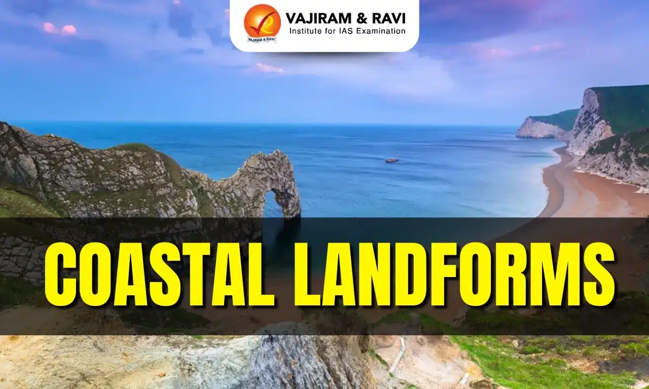
- Sea Arch: Natural bridge created when sea caves enlarge and meet through a headland.
- Stack: Isolated rock pillar formed after collapse of a sea arch.
- Beach: Accumulation of sand or pebbles deposited by low energy constructive waves.
Coastal Landforms FAQs
Q1: What are Coastal Landforms?
Ans: Coastal landforms are natural physical features formed along coastlines by marine erosion, transportation, and deposition processes.
Q2: Which processes mainly shape Coastal Landforms?
Ans: Waves, tides, currents, winds, and sediment movement collectively shape coastal landforms over time.
Q3: What are erosional Coastal Landforms?
Ans: Erosional coastal landforms develop where high energy waves remove rock material, forming cliffs, caves, arches, and stacks.
Q4: What are depositional Coastal Landforms?
Ans: Depositional coastal landforms form when wave energy decreases, allowing sediments to accumulate as beaches, spits, bars, and dunes.
Q5: Why are Coastal Landforms important?
Ans: Coastal landforms influence marine ecosystems, human settlements, coastal management, and natural hazard vulnerability.